2009 SOUTHEASTERN NATURALIST 8(2):293–304
Distribution, Habitat Characteristics, and New
County-level Records of Baccharis halimifolia L. on a
Portion of its Present US Range Boundary
Gary N. Ervin*
Abstract - Baccharis halimifolia (Eastern Baccharis, Silverling, Groundsel-bush, or
Salt-bush) (Asteraceae), a weedy shrub native to the US Gulf and Atlantic Coastal
Plains, is believed to be expanding its distribution throughout much of its native
range and in other regions of the globe to which it has been introduced (e.g., Australia
and Mediterranean Europe). The present survey represents an effort to document the
current distribution of this species across a portion of its apparent interior range limit
in the south-central United States and to record habitat associations of B. halimifolia
within this region. Data support previous research suggesting that B. halimifolia associates
with various forms of canopy-removing anthropogenic disturbance, and that
the limit of this species’ present distribution in the mid-South lies primarily along the
southern half of counties in Tennessee. However, habitat associations did not appear
to vary across the study area, suggesting potential for further expansion into humanaltered
habitats throughout Tennessee and possibly further northward.
Introduction
Baccharis halimifolia L. (Asteraceae), commonly known as Eastern
Baccharis, Silverling, Groundsel-bush, or Salt-bush, is considered native to
the Atlantic and Gulf Coast states of the US from Texas to Massachusetts
(USDA NRCS 2007, Weakley 2007), where it is recognized as a common
species in upland fringes of coastal saline marshes and back dune habitats
(Krischik and Denno 1990). Baccharis halimifolia is a dioecious, woody
perennial that can reach heights of 4 to 6 m, with heights in the range of 2 to
3 m being more typical (Gilman 1999, Nesom 2001). This species exhibits
a semi-deciduous growth habit in the northernmost portions of its North
American range, but it may retain its leaves year-round throughout most
of its global distribution (Krischik and Denno 1990, Westman et al. 1975).
Baccharis halimifolia also exhibits adaptations to a wide range of soil and
environmental conditions including a soil pH range from 3.6 to 9.0, tolerance
to a range of soil nutrient concentrations (nitrogen: 560 to 5500 ppm; phosphorus:
4 to 73 ppm), the ability to survive periodic fl ooding and drought,
and basal resprouting following fire damage (Westman et al. 1975). Despite
the apparently broad environmental tolerances of B. halimifolia, seed production
in this species has been demonstrated to decline significantly under
shaded conditions, one of many indications of this species’ adaptation to
disturbed habitats (Panetta 1977, 1979a).
*Department of Biological Sciences, Mississippi State University, MS 39762;
gervin@biology.msstate.edu.
294 Southeastern Naturalist Vol. 8, No. 2
Wind-pollinated fl owers of B. halimifolia are produced during autumn,
followed by copious production of small, plumed, wind-dispersed achenes
(Krischik and Denno 1990). Seed mass has been reported at approximately
0.1 mg seed-1 (air-dry mass), and as many as 1.5 x 10⁶ achenes may be
produced per plant, with the highest rates of seed production occurring in
the absence of shade (Panetta 1977, Westman et al. 1975). Available data
suggest that in the absence of seed burial, germination follows shortly after
the early winter fruit dispersal. Seedlings then are thought to be capable of
winter establishment, when most neighboring species lay dormant and shading
effects are minimized (Panetta 1977, 1979b).
It has been reported for some time that B. halimifolia is capable of establishing
in interior regions of the southeastern United States, particularly
in disturbed habitats such as fallow fields and hedgerows, as well as inland
saline soils (Krischik and Denno 1990). Areas where B. halimifolia has been
reported include the interior regions of the coastal plains (Duncan 1954,
Krischik and Denno 1990), as well as the Piedmont, Ridge and Valley,
Interior Low Plateau, and possibly even in the foothills of the Blue Ridge
and Cumberland Plateau (Estes 2004, 2005; Weakley 2007). Radford et al.
(1968) indicated that B. halimifolia is thought to be native, and historically
endemic, to the outer coastal plain, but they acknowledged that it had a widespread
distribution at the time of publication of their fl ora. Duncan (1954)
reported that B. halimifolia increased its distribution substantially during the
first half of the 20th century, and was considered in 1954 to be a weed “of
great importance” in Georgia (USA). Outside its native range, B. halimifolia
has become an invasive weed in Australia, France, Spain, and Abkhazia on
the eastern coast of the Black Sea in eastern Europe (Westman et al. 1975).
In its introduced range, B. halimifolia is considered especially problematic
in pasturelands because of the noxious chemistry of the plant’s foliage that
is believed to protect the plant against herbivory and may be toxic to cattle
(Boldt 1989, Kraft and Denno 1982, Nesom 2001).
In the south-central US, this species is now known from the southern
half of Arkansas, throughout Louisiana, four counties in western central Alabama,
the two coastal Alabama counties (Baldwin and Mobile), the southern
two-thirds of Mississippi, and four counties in the northern third of that state
(USDA NRCS 2007). Baccharis halimifolia recently was reported from two
counties in central Tennessee (Estes 2004, 2005), and it presently is known
to occur in only seven counties in western and middle Tennessee (Tennessee
Vascular Plants Database November 2007). However, Estes (2005) indicated
that this Baccharis species should be considered non-native in Tennessee
and ought to be expected in association with human-disturbed habitats
across the southern half of that state.
That Estes expected B. halimifolia could be encountered in disturbed
habitats of southern Tennessee, at the presumed northern extent of the species’
range, is not surprising. Many examples exist of species spreading
outside their historic range in association with human disturbance of natural
2009 G.N. Ervin 295
habitats (Christen and Matlack 2006, Harrison et al. 2002, Shuster et al.
2005). It is widely accepted that changes in the structure and/or function of
natural ecosystems can provide opportunities for invasion and human-assisted
redistribution of species across vast distances (Hobbs 2000, Vitousek et
al. 1997). Examples of such ecosystem change are increased availability of
canopy openings, increased frequency of edge habitat, and provision of dispersal
corridors, such as highways and power line and pipeline rights-of-way
that aid in the spread and establishment of invasive plants (Jules et al. 2002,
Rouget and Richardson 2003, With 2002). Given the natural-history traits
of B. halimifolia, as described above, these factors seem likely to infl uence
its distribution and spread into new habitats within and beyond its historic
native US range. Thus, the objectives of this study were to (1) document the
present distribution of B. halimifolia across a portion of its range in northern
Mississippi and western Tennessee, and (2) to evaluate the degree to which
this species is associated with human disturbance and human-altered landscapes
within the study region.
Methods
Study area
Roadside surveys were conducted for Baccharis halimifolia in 21 counties
of West Tennessee (all counties between the Tennessee and Mississippi
rivers) and in 17 counties of northeastern Mississippi from Oktibbeha
County (location of Mississippi State University) to the TN–MS border to
the north and the AL–MS border to the east (Fig. 1). This region was expected
to provide a gradient of B. halimifolia density, from the known very
high densities encountered in Oktibbeha and Webster Counties of MS (G.N.
Ervin, pers. observ.) into the northernmost counties of western Tennessee,
where B. halimifolia was expected to become absent or of very low frequency
(Estes 2005).
Survey methods
Survey routes (Fig. 1) were selected a priori by using a road atlas to determine
the most efficient routes by which all counties in the selected survey
area could be visited. These routes consisted primarily of state and federal
highways, as those routes constituted the most direct means of transecting
multiple counties in the study area and were readily available as georeferenced
data layers. Data layers for the highways were obtained from the
Mississippi Automated Resource Information System (MARIS; http://www.
maris.state.ms.us/) for Mississippi highways or the National Map Seamless
Data Server (US Geological Survey, EROS Data Center, Sioux Falls, SD)
for highways in Tennessee (Bureau of Transportation Statistics [BTS] Roads
data). For Tennessee routes, the data obtained included all BTS recognized
roads within the map server download window (including all of Tennessee
and portions of adjacent states), so Tennessee state and federal highways were
extracted from those data to make route determination more efficient. The
296 Southeastern Naturalist Vol. 8, No. 2
selected routes were digitized in ArcGIS 9.0 (Environmental Systems Research
Institute, Inc.), converted to an ArcGIS shapefile, and transferred to an
HP iPAQ HX 2110, running Windows MobileTM 2003 second edition, version
4.21.1088. Navigation along the routes was performed with the assistance of
Farm Works Site Mate version 11.40 (CTN Data Service, Inc.) geographic
Figure 1. Map of the study area. Locator map in upper left shows the study area
relative to the remainder of Tennessee and Mississippi. Survey routes are indicated
by the dark line passing through each county or by mapped Baccharis halimifolia
patches. As indicated, counties are shaded based on the frequency of observation of
B. halimifolia patches along the survey route (patches per 20 km of survey).
2009 G.N. Ervin 297
information system (GIS) software and a Holux compact fl ash-card global
positioning system (GPS) unit, model GR-271. Where new highway construction
had occurred since assembly of the transportation GIS data layer,
digitized routes were corrected after the surveys by visual inspection and
comparison with B. halimifolia locations and an independent land-cover data
layer (National Land Cover Dataset 2001 [NLCD 2001], downloaded from
the Multi-Resolution Land Characteristics Consortium: www.mrlc.gov).
The corrected routes are depicted in Figure 1. Data handling within ArcGIS
was performed in the Albers map projection (USA Contiguous Albers Equal
Area Conic, USGS version) and the 1983 North American Datum geographic
coordinate system (NAD 1983). However, data collection in the field was
performed in the 1984 World Geodetic System datum (WGS 1984), and data
were re-projected to NAD 1983 as necessary within ArcGIS.
Rate of travel along routes, including time for stops to record data and
collect voucher specimens, ranged from approximately 24 km h-1 (15 mi h-1)
to 77 km h-1 (48 mi h-1), with a mean of about 59 km h-1 (37 mi h-1). This rate
of travel was infl uenced to a large extent by the class of highway and density
of B. halimifolia along the survey route, with fastest travel in the northernmost
counties of the survey area. The total length of the survey routes was
792 km (495 mi) in Mississippi and 1190 km (744 mi) in Tennessee, with a
total of 1982 km (1239 mi) surveyed. A mean (± 1 SE) of 50 ± 3 km (31 ± 2
mi) were driven in each county.
Farms Works Site Mate also was used as the primary means of data entry
for each logged occurrence of B. halimifolia along the routes. For each patch
observed during this survey, six attributes were recorded (Table 1). Most
patches recorded (≈95%) were estimated to lie within about 30 m of the
road shoulder (i.e., within the right-of-way [ROW] proper); thus, all patches
Table 1. Attributes recorded for each Baccharis halimifolia patch observed during this study.
Attribute Possible levels
Patch size Up to: 5 individuals, 10 indiv., 5 m diameter, 10 m dia., 25 m
dia., 50 m dia., 100 m dia., 200 m dia., >200 m dia., and one
patch >2000 m
Patch density Low, medium, high
Land coverA Wetland-woody, wetland-herbaceous, mixed forest, evergreen,
grassland, shrub-scrub, pasture, cultivated, developed
Habitat type
(as a modifier of land cover) Natural, riparian, fallow (herbaceous), (fallow) shrub, managed,
forest edge, fencerow, pasture, right-of-way, other
Type of disturbance
(where evident) None, construction (included new highway construction), soil
disturbance (including vegetation), vegetation disturbance
only
Canopy presence Canopy, edge, open
ALand cover is based on the Anderson Level II land-cover classes used in the NLCD 2001 Land
Cover Data (Homer et al. 2004). The developed-open, low-, medium-, and high-intensity
classes were collapsed to a single developed class for this study.
298 Southeastern Naturalist Vol. 8, No. 2
were inherently associated with disturbance, and results must be interpreted
in that context. Land cover as recorded was based on the Anderson Level
II land-cover classes (Homer et al. 2004) for the larger area (≈30-m x 30-m
“plots”) in which each patch occurred. Habitat type, as used in this survey,
was intended as a modifier of land cover to indicate the specific location of
the patch itself.
Because of the largely descriptive nature of this study, there was little
need or opportunity for statistical analyses of the data collected. However,
chi-squared tests were conducted to determine quantitatively whether the
observed distribution of B. halimifolia patches among land-cover categories
differed from what would have been expected by chance alone. The relative
percentages of each of fifteen Anderson Level II land-cover classes was
determined within a 50-m buffer on each side of the route driven in these
surveys. Those land-cover data, used to derive expected frequencies for B.
halimifolia patch distribution, were extracted from the NLCD 2001 dataset in
ArcGIS. Expected patch frequency (number of patches per land-cover class)
was calculated as the proportional representation of each land-cover class
within the buffer multiplied by the total number of patches. The chi-square
test statistic then was calculated in the standard fashion, as Σ (O - E)2 ÷ E,
where O = observed number of patches per land-cover class, and E = expected
number of patches per land-cover class.
An additional hard copy datasheet was maintained with data on patch
size, habitat, and observational notes for each observed B. halimifolia
patch. One voucher specimen was collected for each county in which B.
halimifolia was recorded and deposited in the Mississippi State University
herbarium (MISSA; G.N. Ervin collection numbers 258 to 285), including
Lowndes County, which lies just east of Oktibbeha County, the southernmost
county in the survey (Fig. 1). One duplicate voucher was collected for each
county where B. halimifolia was recorded in Tennessee, and those have been
transferred to the University of Tennessee Herbarium (TENN) in Knoxville,
TN, along with data on each patch of B. halimifolia recorded in that state.
Results and Discussion
Six hundred thirty-five patches of Baccharis halimifolia were found during
this study. Fifty-two of these patches were observed in ten counties of
West Tennessee, providing a substantial extension of the recorded distribution
of B. halimifolia in the study area (Table 2). In addition to seven new
county records in Tennessee, nine counties in Mississippi were identified
that appear to be lacking collections of this species, based on inquiries with
state herbaria (Table 2). The nine new Mississippi counties contained 82
patches of B. halimifolia, with only 28 of these occurring in the five counties
bordering Tennessee.
Counties were grouped by patch frequency (patches per 20 km of survey
route) for evaluation of habitat characteristics across the study area (Figs. 1
and 2). Sub-regions of the study area were referred to as having low (up to
2009 G.N. Ervin 299
2.01 patches per 20 km), medium (2.02 to 7.0 patches per 20 km), or high
(more than 7.0 patches per 20 km) frequency of B. halimifolia patches. Because
of the low number of patches in the “low frequency” group, data were
calculated as percent of all patches within each of the three frequency groupings
(nine counties each) for graphical display, instead of simply numbers of
patches (Fig. 2).
With few exceptions, B. halimifolia showed strikingly similar patterns of
association with habitat characteristics across the study area (Fig. 2). Most
patches were small (a few individuals) and of low density, aside from the
“high frequency” counties, where B. halimifolia was found almost equally
in patches of five or fewer individuals (30%) and patches of 50 m to 100 m
diameter (24%). As expected, B. halimifolia tended towards disturbed habitats,
with most patches occurring in association with highway or power line
right-of-way, managed lands (largely pine plantations), and forest edges. All
these areas tended to have low degrees of canopy development, as indicated
by data on canopy development at patch locations and the high prevalence
of vegetation disturbance around observed patches. Land-cover classification
tended to support the association with disturbance as well, with a third
or more of the patches (30 to 45%) in areas of developed land-cover and
another 20 to 30% associated with scrub-shrub cover, which most frequently
was harvested timber land. Very few patches were associated with wetland
areas and natural habitats, and most of those were in the northern region of
the study area (low patch-frequency group).
Chi-squared analyses indicated that the distribution of B. halimifolia
differed from what one would expect by chance, based on the proportional
cover of land use along the survey route. Because of the low numbers of
patches in some groups, even in the cumulative data set for the entire study
area, four land-cover categories (open water, barren, grassland/herbaceous,
and emergent herbaceous wetland Anderson Level II categories) were
lumped for the chi-squared analysis. Additionally, all developed land cover
was lumped in the road surveys, so the same procedure was followed for this
Table 2. Counties believed to represent new records in the distribution of Baccharis halimifolia.
This list is based on inquiries with major herbaria in Mississippi (MISS, MISSA, MMNS,
SWSL, USM), the herbarium of the University of Tennessee (TENN; online database), and
information contained in Estes (2005).
State Counties with presumably new recordsA
Mississippi AlcornB, BentonB, ItawambaB, Lee, MarshallB, PrentissB, TippahB, TishomingoB,
UnionB
Tennessee Dyer, Fayette, Hardeman, Haywood, McNairy, Shelby, Tipton
AAlthough not in the official survey area, Baccharis halimifolia also was collected in Lowndes
County, MS, which lies immediately to the east of the southernmost county in Figure 1. A less
thorough count of patches in Lowndes County yielded 37 patches along a 45-km route (16.4
patches per 20 km), with patches ranging in size from a single plant to greater than 200 m
diameter. These were located in virtually all of the land-cover types included in the survey.
BEight of the nine new counties in MS either border TN or border a county that does. That is,
those eight are within the northernmost two tiers of MS counties.
300 Southeastern Naturalist Vol. 8, No. 2
Figure 2. Comparison of Baccharis halimifolia habitat characteristics in counties with
low, medium, and high patch frequencies. Category labels are described in Table 1.
2009 G.N. Ervin 301
quantitative analysis; all four levels of developed land cover (open and low-,
medium-, and high-intensity developed spaces) were lumped for analysis.
The results indicated that the observed distribution of B. halimifolia differed
significantly from expected in each of the three sub-regions of the study
area (χ2
LOW = 47.6; χ2
MED = 213; χ2
HIGH = 1160; df = 8 and P < 0.001 for all).
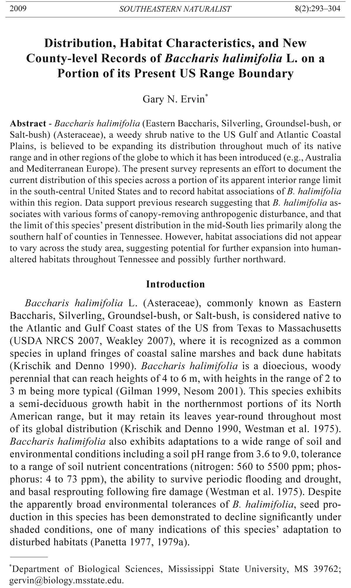
Among the nine land-cover categories used in these analyses, scrub/shrub
Figure 3. Baccharis
halimifolia
distribution
in the
United States
(upper), relative
to USDA
Plant Hardiness
Zones
( l o w e r ) .
County distribution
is based
on data collected
in the
present study,
supplemented
with county
record data
from USDA
PLANTS database
and the
U n i v e r s i t y
of Tennessee
herbarium online
database.
Plant Hardiness
Zone
map, 2001 edition,
courtesy
of the US National
Herbarium,
USDA.
Values given
for each zone
(lower map)
are the mean
annual minimum
temperatures
(ºC).
302 Southeastern Naturalist Vol. 8, No. 2
land cover consistently had more than the expected number of patches, and
developed land cover was occupied less frequently than expected. Thus,
it seems B. halimifolia was observed most frequently in areas that have been
disturbed but where some secondary succession had occurred.
That there were few qualitative differences in habitat associations of
Baccharis halimifolia across the study area suggests that this species is not
limited by habitat availability across its present range in Mississippi and
Tennessee. This distribution may be due, in large part, to its tendency of
inhabiting human disturbed habitats, exemplified by the dense cluster of
large patches in Decatur County, TN (northeastern most county occupied
by B. halimifolia in Fig. 1). All fourteen of these patches fell within an area
of relatively new four-lane divided highway construction (Tennessee State
Highway 69), with varying levels of new construction and mowing disturbance.
These results, in combination with the experimentally demonstrated
broad habitat tolerances of B. halimifolia (Panetta 1977, 1979a; Westman et
al. 1975), suggest strongly that climate may be the most infl uential variable
in determining potential range expansion within the present US distribution
of Baccharis halimifolia.
Currently, B. halimifolia is recorded from areas of Massachusetts, Rhode
Island, Connecticut, New York, New Jersey, and Pennsylvania within USDA
Plant Hardiness Zones 6a and 6b (Fig. 3; Cathey 1990, USDA NRCS 2007).
In Tennessee, B. halimifolia presently is known from at least one location
in Plant Hardiness Zone 6a, in Rutherford County (northernmost county
in the center of Tennessee; Fig. 3). A nearby county with patches of B.
halimifolia–Maury–County, lies approximately equally in zones 7b and 6a,
but all Tennessee patches identified in the present study fell within zone 7b.
If the climate throughout zone six in the US (yellow zones) were suitable for
growth and reproduction of B. halimifolia, this species could be expected
eventually to expand its range throughout Tennessee and Kentucky, and possibly
into states farther north, taking advantage of suitable habitats in areas
from the Ohio River Basin to the Gulf and Atlantic Coasts (Fig. 3).
Acknowledgments
This work was supported by funding from the US Geological Survey Biological
Resources Discipline (04HQAG0135), US Department of Agriculture (2007-55320-
17847), and the Mississippi Computational Biology Consortium (NSF EPSCoR
#EPS-0556308). Assistance in data collection was provided by T. Ervin and G.L.
Ervin. Chris Holly, Lucas Majure, and two anonymous reviewers provided helpful
critique of an earlier version of this paper. Christopher Brooks provided statistical
advice. Special thanks are due to Ramon Jordan, Research Plant Pathologist with
the USDA-ARS, US National Arboretum Floral and Nursery Plants Research, for
providing a high-resolution version of the plant hardiness zone map.
Literature Cited
Boldt, P.E. 1989. Biology and host specificity of Trirhabda bacharidis (Coleoptera:
Chrysomelidae) on Baccharis (Asteraceae: Asterae). Environmental Entomology
18:78–84.
2009 G.N. Ervin 303
Cathey, H.M. 1990. USDA Plant Hardiness Zones Map. USDA Miscellaneous Publication
No. 1475, US National Arboretum. Available online at http://www.usna.
usda.gov/Hardzone/ushzmap.html. Accessed 11 November 2007.
Christen, D., and G. Matlack. 2006. The role of roadsides in plant invasions: A demographic
approach. Conservation Biology 20:385–391.
Duncan, W.H. 1954. More and more weeds in Georgia. Bulletin of the Georgia Academy
of Science 12:99–103.
Estes, D. 2004. Noteworthy collections: Middle Tennessee. Castanea 69:69–74.
Estes, D. 2005. The vascular fl ora of Giles County, Tennessee. Sida 21:2343–2388.
Gilman, E.F. 1999. Baccharis halimifolia. Environmental Horticulture Department
Fact Sheet FPS-58, Florida Cooperative Extension Service, Institute of Food and
Agricultural Sciences, University of Florida, Gainesville, FL.
Harrison, S., C. Hohn, and S. Ratay. 2002. Distribution of exotic plants along roads
in a peninsular nature reserve. Biological Invasions 4:425–430.
Hobbs, R.J. 2000. Land-use changes and invasions.Pp. 55–64, In H.A. Mooney and R.J.
Hobbs (Eds.) Invasive Species in a Changing World. Island Press, Washington, DC.
Homer, C., C. Huang, L. Yang, B. Wylie, and M. Coan. 2004. Development of a 2001
national land-cover database for the United States. Photogrammetric Engineering
and Remote Sensing 70:829–840.
Jules, E.S., M.J. Kaufmann, W.D. Ritts, and A.L. Carroll. 2002. Spread of an invasive
pathogen over a variable landscape: A nonnative root rot on Port Orford
cedar. Ecology 83:3167–3181.
Kraft, S.K., and R.F. Denno. 1982. Feeding responses of adapted and non-adapted
insects to the defensive properties of Baccharis halimifolia L. (Compositae).
Oecologia 52:156–163.
Krischik, V.A., and R.F. Denno. 1990. Differences in environmental response between
the sexes of the dioecious shrub, Baccharis halimifolia (Compositae).
Oecologia 83:176–181.
Nesom, G. 2001. Groundsel Tree—Baccharis halimifolia L. USDA Natural Resources
Conservation Service Plant Guide. Available online at http://plants.usda.
gov/factsheet/pdf/fs_baha.pdf. Accessed 10 October 2007.
Panetta, F.D. 1977. The effects of shade upon seedling growth in Groundsel Bush (Baccharis
halimifolia L.). Australian Journal of Agricultural Research 28:681–690.
Panetta, F.D. 1979a. The effects of vegetation development upon achene production
in the woody weed, Groundsel Bush (Baccharis halimifolia L.). Australian Journal
of Agricultural Research 30:1053–1065.
Panetta, F.D. 1979b. Germination and seed survival in the woody weed, Groundsel
Bush (Baccharis halimifolia L.). Australian Journal of Agricultural Research
30:1067–1077.
Radford, A.E., H.E. Ahles, and C.R. Bell. 1968. Manual of the Vascular Flora of the
Carolinas. University of North Carolina Press, Chapel Hill, NC.
Rouget, M., and D.M. Richardson. 2003. Inferring process from pattern in plant
invasions: A semimechanistic model incorporating propagule pressure and environmental
factors. American Naturalist 162:713–724.
Shuster, W.D., C.P. Herms, M.N. Frey, D.J. Doohan, and J. Cardina. 2005. Comparison
of survey methods for an invasive plant at the sub-watershed level. Biological
Invasions 7:393–403.
US Department of Agriculture (USDA), Natural Resources Conservation Service
(NRCS). 2007. The PLANTS Database. National Plant Data Center, Baton
Rouge, LA 70874–4490 USA. Available online at http://plants.usda.gov. Accessed
20 September 2007.
304 Southeastern Naturalist Vol. 8, No. 2
Vitousek, P.M., H.A. Mooney, J. Lubchenco, and J.M. Melillo. 1997. Human domination
of Earth’s ecosystems. Science 277:494–499.
Weakley, A.S. 2007. Flora of the Carolinas, Virginia, and Georgia and surrounding
areas. UNC Herbarium, North Carolina Botanical Garden, University of North
Carolina at Chapel Hill. Available online at http://www.herbarium.unc.edu/fl ora.
htm. Accessed 20 February 2008.
Westman, W.E., F.D. Panetta, and T.D. Stanley. 1975. Ecological studies on reproduction
and establishment of the woody weed, Groundsel Bush (Baccharis halimifolia
L.: Asteraceae). Australian Journal of Agricultural Research 26:855–870.
With, K.A. 2002. The landscape ecology of invasive spread. Conservation Biology
16:1192–1203.


 The Southeastern Naturalist is a peer-reviewed journal that covers all aspects of natural history within the southeastern United States. We welcome research articles, summary review papers, and observational notes.