Site by Bennett Web & Design Co.
Journal of the North Atlantic
G. Sveinbjarnardóttir
2018 Special Volume 11
1
Introduction
“At that time Iceland was covered with woodland
between mountain and seashore” (“Í þann
tíð vas Ísland viði vaxit miðli fjalls ok fjöru”)
(Íslendingabók, 5). This sentence from the Book of
Icelanders, Íslendingabók, which is a short history
of the earliest habitation in Iceland, written in the
12th century, is often quoted to demonstrate the rapid
change that occurred in the vegetation cover of the
country at the time of settlement, now generally acknowledged
to have taken place in the second half
of the 9th century. The text, written some 250 years
after the time of settlement, suggests that the author
had some knowledge of what the environment may
have been like about two and a half centuries earlier.
Archaeological and environmental research has
proved his statement to have some substance.
A pioneer in the study of environmental change
was geologist Sigurður Þórarinsson, who laid the
foundation for the study of volcanic ash layers
(tephra) in Iceland (Þórarinsson 1944), which are
extensively used for dating changes in the environment
and also in archaeological research. In the
latter discipline volcanic ash layers are for example
found in the building turf and also sealing structures,
showing, respectively, after and before what time
they were built. The various ash layers, which are
deposited in layers to form stratigraphic markers,
have been dated on the basis of written sources,
radiocarbon dates and stratigraphy, creating what
Þórarinsson called tephrochronology (Þórarinsson
1981, Larsen 1996). In his research Þórarinsson
pointed out that there was a tremendous increase in
erosion at the point where landnám sets in, marked
by a volcanic ash layer which until recently was
conveniently dated to AD 871 ± 2 (Grönvold et al.
1995), now revised to AD 877 ± 1 (Schmid et al.
2017). Because of its date, close to when the country
is, based on written sources, assumed to have been
settled, it is generally called the landnám layer.1
Although it is not disputed that there were drastic
environmental changes at landnám, views vary as
to the temporal, spatial and social aspects of these
processes, which are increasingly being shown not
to have been as clear cut as suggested by Þórarinsson
and others, or indeed the same everywhere in
the country (e.g., Dugmore and Buckland 1991,
Gathorne-Hardy et al. 2009, Lawson et al. 2007,
Ólafsdóttir et al. 2002, Streeter and Dugmore 2014,
Vickers et al. 2011).
Estimates of vegetation cover at the time of settlement
vary depending on the methods used. Thus,
a modelling study based on estimates of dynamics
of the vegetation cover in response to temperature
change suggests that total vegetation cover of
Iceland decreased from around 52% at landnám to
28% in 1990, and that the birch (Betula) woodland
cover during the same period decreased from an
estimate of 8% to ca. 1% (Ólafsdóttir et al. 2001,
Streeter et al. 2015). The estimates based on the
present-day spatial distribution of birch, historical
sources and geographical information which suggest
in which areas birch could never have thrived gave
different results, suggesting that woodland covered
at least 25% of the country at the beginning of settlement,
with the total vegetation cover being ca. 65%
(e.g., Arnalds 1987). Today woodland coverage is
on the increase due to preservation and plantation
work. The indigenous woodland species are birch
and willow. Birch can grow to considerable heights
under favourable conditions, but much of the
woodland cover probably consisted of low-growing
bushes or brushwood.
Archaeological, Written, and Palaeoecological Evidence for Environmental
Change in the Wake of Settlement in Iceland: Two Case Studies
Guðrún Sveinbjarnardóttir*
Abstract - A 12th century source (Íslendingabók) suggests that Iceland was wooded “between mountain and seashore” when
the country was first settled in the ninth century. Today only ca. 1% of the surface of the country is wooded and large areas
have suffered heavy erosion. The results of the earliest investigations undertaken of environmental change gave a rather
uniform picture, showing an equally drastic escalation in erosion and decline in woodland right at landnám, the time when
the country is thought to have been settled. Recent research suggests a more diverse picture. This is for example evident
in the two areas, Eyjafjallasveit in the South and Borgarfjörður in the West discussed in this article, for which the historical,
archaeological and palaeoecological evidence for changes in the environment in the wake of the earliest settlement is
surveyed. It demonstrates that the effect of landnám on the environment is not a uniform event which can be applied equally
to all sites. A combination of evidence from different disciplines is more likely to provide a truer picture of developments.
Selected Papers from the North Atlantic Archaeology Group 2013 Symposium
Journal of the North Atlantic
*Department of Scandinavian Studies, University College London, London WC1 E6BT, gudrun.s@ucl.ac.uk.
2018 Special Volume 11:1–12
Journal of the North Atlantic
G. Sveinbjarnardóttir
2018 Special Volume 11
2
The favoured explanations for the reduction of
the woodland cover have been (i) clearance by the
initial settlers to make way for cultivation, for which
there is some evidence (e.g., Byock 2001:33, Smith
1995:334, Sveinbjarnardóttir et al. 2011:166, Þórarinsson
1944:192ff), (ii) coppicing for charcoal making,
which was used for the extraction of iron from
iron-ore, and (iii) sheep grazing, suggesting that the
sheep, if allowed to graze in the woodland, would
cause woodland regeneration failure (e.g., Einarsson
1962:452, Smith 2005:187).
Pollen work carried out at several sites in the
south-west of the country shows that the woodland
was on the decline already before the deposition
of the landnám tephra, and that it declined
dramatically after that time, when there is also
a dramatic increase in grasses, a consequence
of the opening up of former wooded areas for
the expanding grassland (e.g., Einarsson 1962,
Hallsdóttir 1996). This evidence for the arrival of a
human population and its effect on the environment
is certainly fairly clear cut and dramatic, and all
these early charts tell a very similar story about the
development of the birch and the grasses.
More recently, pollen work has been carried
out in other areas showing certain variations in
the development of landscape change, calling for
different explanations. One of those areas is the
Reykholtsdalur valley in the west of Iceland. Here
there was birch woodland present in the valley
bottom pre-landnám which was quickly cleared soon
after the earliest settlement, while the birch on the
slopes lingered on until about AD 1150 when it also
began to disappear (Erlendsson et al. 2012). Similar
results have been obtained from sites in the north of
Iceland (Lawson et al. 2007).
There could be different reasons for this later
clearance of the woodland in some locations. Some
researchers have interpreted it as an attempt to
manage the use of the woodland which remained
after the initial onslaught in the wake of the earliest
settlement (Vésteinsson and Simpson 2004). Others
have pointed out that this remaining woodland is
further away from the farm and was, for that reason
simply used later (Erlendsson et al. 2012).
Medieval written sources suggest that the right
of access to woodland was an important asset. The
largest holders of this right were the church farms
and it is in the church charters that the earliest
information on this is to be found. For Eyjafjallasveit
in the South, one of the areas discussed in this
article, the earliest charters date from about AD
1270 (DI 2, 84–85), and for Reykholtsdalur in the
West, the second study area, from about AD 1150
(DI 1:279–280, Gunnlaugsson 2018).
An indication of how important woodland
and its preservation was, is the fact that Grágás, a
collection of medieval laws compiled in the latter
half of the 13th century, has paragraphs in its Land-
Claims Section on how to deal with woodland when
land changes hands (Grágás 1992:289), and how to
behave in and divide co-owned woodland (Grágás
1992:326–330). Here the uses to which woodland
is put are specified as being fuel for cooking, as
building material, for making charcoal to sharpen
scythes by, and for mending domestic items. The
importance of this asset and the punishment for misbehaving
with it is made very clear.
In the following, some of the literary,
archaeological and palaeoecological evidence for
changes in the environment, particularly as concerns
the woodland cover, in the wake of the earliest
settlement is discussed in two areas in Iceland: the
western extremity of Eyjafjallasveit in the South
and the Reykholtsdalur valley, together with one of
its shieling areas, in the West. The present author
has carried out research in both areas, including as
a member of the Leverhulme Trust funded project
Landscapes circum landnám (Edwards et al. 2004)
which involved a great amount of environmental
work. The study of the archaeological remains in
Þórsmörk formed part of an earlier Leverhulme
Trust funded project (Sveinbjarnardóttir 1983). The
site of Reykholt has been the subject of extensive
excavations (Sveinbjarnardóttir 2012, 2016) and
its shieling areas were the subject of the Reykholt
shieling project (e.g., Sveinbjarnardóttir et al.
2011). This article re-visits all this research, adding
information from written sources on the ownership
of woodland, with the aim of re-assessing the
evidence and testing the findings in the light of
present knowledge in the field.
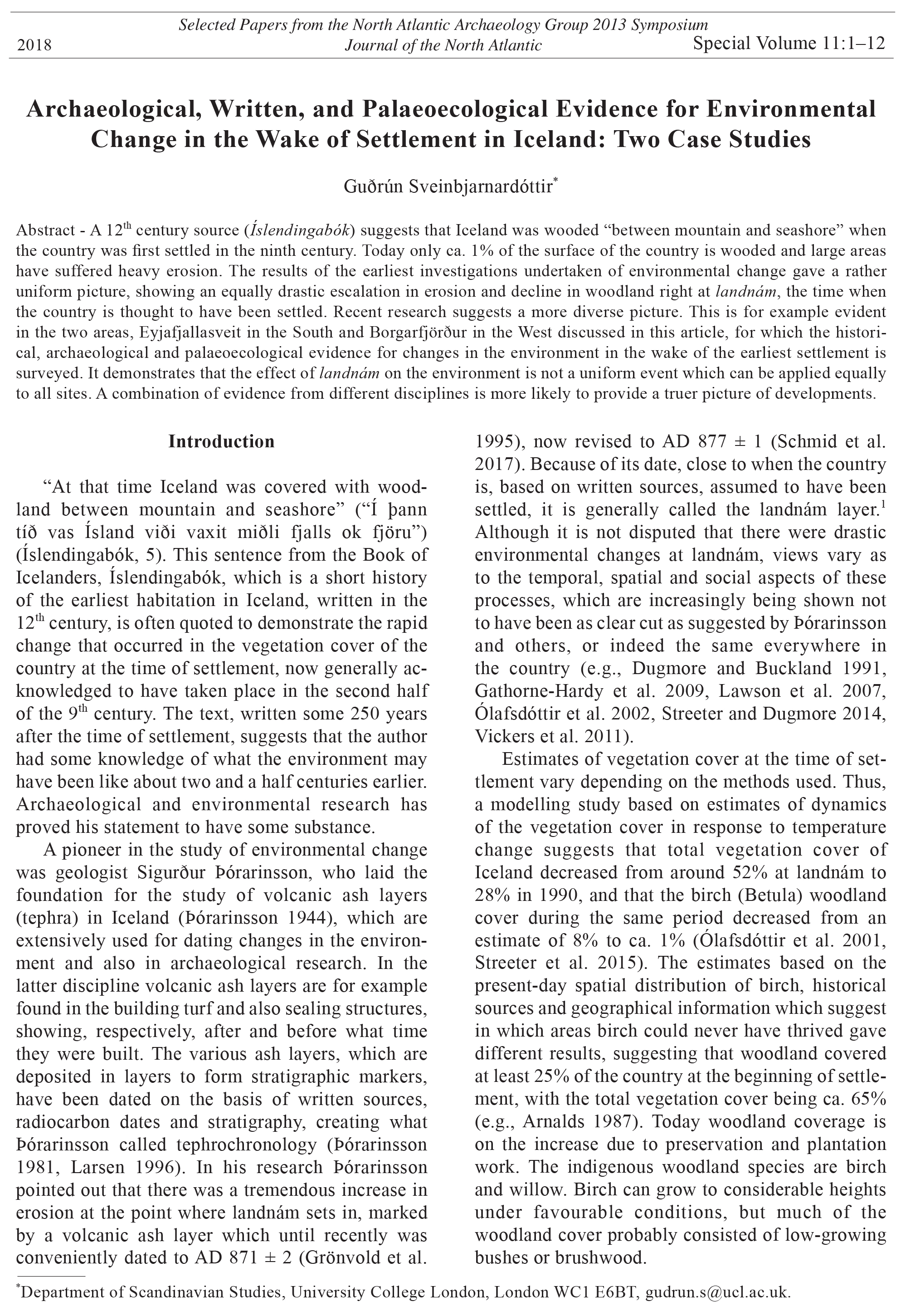
Case study I: Eyjafjallasveit
Eyjafjallasveit lies just west of the southernmost
point of Iceland (Fig. 1). It is bounded by large glacial
rivers to the east (Jökulsá á Sólheimasandi), west (Álar,
a tributary of Markarfljót) and north (Markarfljót),
and crowned by the glacier Eyjafjallajökull at its
northern boundary. The area is now virtually devoid
of trees, except for the inland area of Þórsmörk and
parts of Langanes, the stretch of land running alongside
the northern boundary towards Þórsmörk, where
there is low-growing brushwood. Þórsmörk was
formerly a pasture area for the lowland settlements
and an important source of wood, and attempts were
made to establish permanent farms there during the
earliest phase of settlement. Now parts of it have been
fenced off and turned into a National Park. Until the
recent past Langanes was also an important source of
woodland.
Journal of the North Atlantic
G. Sveinbjarnardóttir
2018 Special Volume 11
3
There are several place-names in the area which
can be translated as “woods” indicating that the
sites were covered with woodland in the past. At
the eastern boundary there is the farm Skógar, in the
middle of the area there is Holt which was a major
church seat and at the western boundary there are the
Mörk farms. At none of these sites is there woodland
today. Þórsmörk, where there is still some woodland,
means the woods of the pagan god Þór. Supporting
this place-name evidence of past woodland are treetrunks,
often of considerable size, which have been
found in pre-settlement deposits at Stóramörk (Mairs
et al. 2006) and Holt (Buckland et al. 1991).
The historical, archaeological and environmental
evidence
Several early settlement sites are known in
Þórsmörk (Sveinbjarnardóttir 1983, 1992;
Tómasson 1996). At two of them, Steinfinnsstaðir
and Þuríðarstaðir efri, slag was found on the surface
and analysed as ironworking slag, both smithing and
smelting slag (McDonnell 1983). For both activities
charcoal is needed. At a third site a quantity of
slag was also found on the surface, but it has not
been analysed (Tómasson 1996:130ff). The sites in
Þórsmörk, all of which are now heavily eroded (Fig.
2), have not been excavated, but have been dated
to the earliest period of settlement on the basis of
artefacts found, including a bead and a Borre style
buckle, both of which can be dated to the 10th century
(Fig. 3) (Callmer 1977:77, 85; Graham-Campbell
2013:70). The presence of pagan graves in the area
(Eldjárn 2000:46–49), also suggests an early date for
the settlement. The Pagan religion was the dominant
one in Iceland until Christianity was adopted in ca.
AD 1000 (see e.g., Vésteinsson 2000:50). It may
be easily assumed that Þórsmörk was an attractive
place to settle being wooded and secluded, at least
until erosion set in making parts of it uninhabitable.
The woodland is now thriving again in places after
being fenced off and protected from sheep and exploitation
by humans.
Evidence has been obtained of landscape
instability in Þórsmörk between the eleventh and
thirteenth centuries, after which there is some improvement
in the stability (Dugmore et al. 2006).
The period of instability coincides with the duration
of settlement in the area. According to contemporary
written sources the farms were already abandoned
by the 13th century (Biskupa sögur I, 291, Sturlunga
saga I, 532). Although this may have been as a result
of erosion, it has been suggested that the church
Figure 1. Map showing the study area in Eyjafjallasveit with some of the
place names mentioned in the text.
farms which owned the woodland at
that time wanted to preserve it for
their own use when woodland in the
lowland had disappeared. Ownership
of woodland in Þórsmörk is reported
in the earliest preserved charters for
the church at Stóridalur, which date
to the 14th century (DI 2, 683, DI 3,
262–263), for the church at Holt dating
to the 13th, 14th and 15th centuries
(DI 2, 84–85, 681–682, DI 6, 329–
330) and the church at Miðbæli from
the 13th century (DI 2, 678–679, DI 3,
260) (see Fig. 1). All these churches
also owned woodland in Langanes,
the stretch of land between the Mörk
farms and Þórsmörk.
Church charters, which were
mainly compiled until the Reformation,
list the most valuable assets belonging
to the church at any given time. The
comprehensive reporting in them
of woodland ownership shows how
important it was in the medieval period.
The Bishop visited once a year and
amended the charter as appropriate.
There is no information to be had from
them later than the 15th century, but by
Journal of the North Atlantic
G. Sveinbjarnardóttir
2018 Special Volume 11
4
1709, when the first land survey was carried out in
Eyjafjallasveit, the woodland belonging to all these
churches was much depleted, and only with difficulty
said to be still usable for charcoal making in places
(JÁM 1, 48, 62, 92).
No charcoal pits have been discovered in
Þórsmörk, but several have been found on the
eroded slopes of Langanes, the stretch of land
leading into Þórsmörk from the west. The use of
these pits has been dated with tephrochronology,
analysis of soil accumulation rate estimates and
radiocarbon dating to between the mid tenth and
late thirteenth centuries. The pits are consistently
cut through a tephra layer dated to AD 920 and
sealed by the AD 1341 Hekla tephra layer with a
considerable soil accumulation between the latter
and the pit, estimated to represent close to one
century (Dugmore et al. 2006).2 One of the pits
had two charcoal fills (Dugmore et al. 2006, Table
1, Church et al. 2007, Table 1), suggesting that
it was re-used at least once. It is clear that these
pits were filled with soil after the coal had been
removed, probably to avoid the hazard of domestic
animals falling into them. The back-filling of
charcoal pits is specified in the lawbook Grágás,
where charcoal makers are also required to remove
the charcoal from the pit within a specific
period of time if they are making coal in the land
of someone other than themselves, or face a fine
(Grágás 1992:329).
Environmental evidence obtained through a
stratigraphic study of macrofossil remains and
sediment-accumulation rates close to the farm of
Stóramörk, with dating based on tephrochronology,
suggests the existence of woodland cover close to the
farm during its earliest occupation; the same research
study suggests its disappearance before AD 920. Between
AD 920 and AD 1341 the site suffers heavier
erosion than any other settlement in the area, includ-
Figure 2. One of the eroded sites in Þórsmörk.
Figure 3. Viking age artefacts found in Þórsmörk.
Journal of the North Atlantic
G. Sveinbjarnardóttir
2018 Special Volume 11
5
ing those in Þórsmörk (Mairs et al. 2006). A charcoal
pit was found close to Stóramörk. A sample of charred
birch from the pit gave dating estimates that fall between
AD 865 and AD 960 (Church et al. 2007). This
is an earlier date than those on the pits found further
away in Langanes to the east of the farm, suggesting
that the latter were in use later. The evidence from
Stóramörk is from a single trench and therefore localized,
but one interpretation for these results is that
they may show how woodland exploitation moved to
areas in the interior of Iceland as the lowland woodland,
closest to the farms, disappeared (Dugmore
et al. 2006:342–343). As the woodland diminished,
it would have been important to manage what was
left of it in the interior. This may be visualized in
the later medieval woodland preservation described
above, evident in the environmental data from both
Þórsmörk and Þjórsárdalur, a valley somewhat further
to the west, where a similar study has been carried out
(Dugmore et al. 2007).
Case study 2: Reykholtsdalur
The second study area is Reykholtsdalur in
Borgarfjörður in the West (Fig. 4). It is an inland valley
which lies about 25 km from the coast, bordered
by rivers to the north (Hvítá) and south (Reykjadalsá).
The focus of this study was the Reykholt estate, a
church farm and chieftain’s centre where extensive
excavations have been carried out (Sveinbjarnardóttir
2012, 2016). The site is best known for its 13th century
occupant, the author and chieftain Snorri Sturluson.
Shieling sites (summer farms) which belonged
to Reykholt from the earliest period of its settlement
were also studied, in a parallel lying valley to the
north (1 and 2 in Fig. 4) and to the south (3). Reykholt
also had a right to resources in a third area (4), in the
interior to the east.
Today the Reykholtsdalur valley is
The historical, archaeological and environmental
evidence
In addition to Reykholt, only one other site in
the valley has been subjected to archaeological
investigations. This is the cottage farm Háls which
lies some distance up the valley. Smithing and
smelting slag was discovered at both sites, as well
as pits for charcoal making or storage. All of this
activity points to the exploitation of woodland. Some
of the evidence has been dated to the earliest period
of settlement. Tree trunks have also been found in
ditches in pre-historic layers, e.g., at Grímsstaðir,
the neighbouring farm to Reykholt down the valley,3
as well as the shieling area belonging to Reykholt in
the Kjarardalur valley which lies to the north of the
Reykholtsdalur valley (Erlendsson et al. 2018, Fig.
7C). In the earliest preserved charter, now thought
to date to about AD 1150 (Gunnlaugsson 2018),
the church at Reykholt is said to own shielings in
this valley, as well as the right to woodland in that
general area, and also in the inland area of Geitland
(no. 4 in Fig. 4) (DI 1, 279–280). Ownership of these
resources is repeated in thirteenth, fourteenth and
15th century charters (DI 1, 466–480, DI 3, 122–123,
222, DI 6, 173–174).
Like in Eyjafjallasveit, the account in the earliest
land survey carried out in the area in 1709 shows
that woodland in these areas is depleted. Instead,
Reykholt relies on woodland on one of the farms
it now owns, Hraunsás (see below), as well as
driftwood rights in the Western Fjords (JÁM 4,
230–231).
At the site Háls, charcoal remains were found
that seem to indicate burning for clearance before
the site was settled in the 10th century (Smith 1995).
The investigations have also revealed remains of
Figure 4. Map showing the study area in Reykholtsdalur with some of the
place names mentioned in the text.
completely devoid of trees, but
evidence has been retrieved which
suggests that it was wooded
before the settlement. This is not
supported by any place-names like in
Eyjafjallasveit, but by pollen evidence
and tree-trunks which have been
discovered in pre-settlement deposits
(see below). The Reykholt site and
its surrounding area has been the
subject of extensive environmental
investigations, carried out as part
of the project Landscapes circum
landnám (e.g., Sveinbjarnardóttir et
al. 2007). The Reykholt shielings
project also placed importance on
environmental investigations (e.g.,
Sveinbjarnardóttir et al. 2011).
Journal of the North Atlantic
G. Sveinbjarnardóttir
2018 Special Volume 11
6
ethnographic evidence describes charcoal making
pits as varying in size depending on how much coal
was to be made. Thus, a pit making enough coal
for 4–5 barrels was 1.9 m in diameter and 1 m deep
(Þórarinsson 1974:26). Unfortunately, the earliest
archaeological remains at Reykholt were too badly
preserved to put the charcoal pit found there into
a secure context. Its function is a mystery, but one
suggestion is that it may simply have served as a
storage pit.
The results of pollen analysis carried out by Egill
Erlendsson on samples from the Reykholtsdalur
valley close to the site of Reykholt show how, before
settlement, the valley bottom consisted of wetland
with drier patches where trees or shrubs of low
stature grew. These would have been easy to clear
for agriculture, an activity which is evident in a decline
of annual deposition of birch pollen. The trees
on the valley slopes were sturdier and lingered on
until the mid-12th century when a decline becomes
evident, and by ca. AD 1300 the woodland up there
had disappeared as well (Erlendsson et al. 2012,
2018). The pollen charts show the usual tremendous
increase in grasses right at landnám, probably a
result of the disappearance of the woodland, which
also manifests itself in a drop in soil organic matter
(Erlendsson et al. 2018). The species also indicate
drainage, a sign of the introduction of agriculture,
and there is evidence of barley growing (Hordeum),
a clear sign of the appearance of humans, until ca.
AD 1300 when it disappears (Erlendsson et al. 2012,
Fig. 9). This is in keeping with written evidence
of cereal growing at the Reykholt farm which,
according to the sources, had ceased by the 14th century
(DI 3, 122–123). Some barley grains were also
found during the excavation and dated to the earliest
period at the site (Sveinbjarnardóttir 2012, Table 2).
Further support for the decrease in the woodland
is apparent in the results of micromorphological
investigations on material from a midden (577) at
the farm site which indicate that there was a change
in the fuel use at Reykholt after ca. AD 1300 when
peat and dung became more prominent than wood
(Sveinbjarnardóttir et al. 2007, 198ff). This shift in
the type of fuel is not evident in the written sources
until 1708 when peat is said to be available for
that purpose in the land of Steindórsstaðir (JÁM 4,
230–231), a farm just to the south of Reykholt.
The Shielings of Reykholt
As part of The Shielings of Reykholt project two
sites, now known as Norðtungusel and Reykholtssel
(2 and 1 respectively in Fig. 4), and known
from written sources to have been owned by the
charcoal making and iron-ore-extraction before
the site was settled as a farm (Smith 2005). This is
interpreted as the sole purpose of the site before it
became a farm. The site lies on the boundary between
two of the original land takings (landnám) in the district,
and investigations show that the area was covered
with woodland at the time of settlement. When
enough woodland had been cleared so that farming
could begin at the site, a farm was established. It
does not seem to have been a suitable location for a
farm, however; it was abandoned in the 13th century
and never re-occupied.
The stretch of land to the north of Háls, along
the Hvítá river on the north side of the mountain
ridge, from the other large landowner and church
farm, Stóri Ás, to Reykholt, was wooded in the past.
Remnants of this still existed when the land survey
was made for this area in 1708 (JÁM 4, 241–243).
Most of this land, together with its woodland, will
have belonged to Stóri Ás as indicated by its charter
of AD 1258 (DI 1, 593–594), although by at least
ca. AD 1600 Reykholt held some land there as well
(Jarðabréf, 32, 34). In the 15th century Reykholt had
also acquired half of the farm Hraunsás, located
somewhat further inland on that side of the mountain
ridge, which had good woodland (DI 5, 399–400).
It has been suggested that it may, indeed have been
Reykholt’s main reason for acquiring the farm
(Eyþórsson 2008:67).
The excavations at Reykholt produced evidence
of ironworking in two places at the site: in the
form of slag at the farm site itself and in a smithy
to the north of the church, from where charred
birch was dated with estimates ranging from AD
1030 to AD 1260. Also found at the farm site was
a small pit filled with charcoal which, because of
its homogeneity is thought to be the product of
charcoal-making. Radiocarbon estimates date it to
the earliest period of occupation at the site, around
AD 1000 (Sveinbjarnardóttir 2012:58, 88, and
Table 2). The pit, which is square in shape, is rather
smaller (0.55 x 0.53 x 0.32 m) than known charcoal
making pits from the medieval period which are also
closer to being circular in shape. For comparison,
the charcoal pits found in Langanes ranged from ca.
0.95 x 0.5 m (Church et al. 2007, Fig. 2) to ca. 2 x 1
m (Dugmore et al. 2006, Fig. 8), whereas the largest
charcoal making pit found at Háls was 3 x 1 m in
size (Smith 2005:190), which implies that it served
to make a large quantity of coal, almost certainly
for commercial rather than domestic use. This is in
keeping with the interpretation of the earliest phase
of activity at the site being charcoal making and
iron-ore extraction (see above). Late-19th century
Journal of the North Atlantic
G. Sveinbjarnardóttir
2018 Special Volume 11
7
ore and that fuel may have been scarce when it was
produced.4 This is supported by the pollen data
which show that there was a new period of environmental
decline in the valley after ca. AD 1500
which lasted until about AD 1700, interpreted as
showing increased grazing pressure. The timing of
this event coincides with the operation of shieling
(1), according to the historical and archaeological
evidence, which is close to the sampling site
(Erlendsson et al. 2018).
Whether the piece of slag found at site (2) is
evidence of iron-ore extraction in the valley or was
carried to the site from elsewhere is not known. Its
presence at the site is of interest because iron-ore
extraction was practiced at Norwegian shielings.
Although such activity is known from Icelandic
sites, such as Háls discussed above, no such evidence
has so far been found at Icelandic shieling sites. It is
possible that the woodland in Kjarardalur was never
of good enough quality for charcoal making. In the
earliest source for the shieling activity in the valley
it is specifically mentioned that wood to be used at
the shieling is available from Þverárhlíð, an area to
the north and west of the valley (DI I, 279–280). The
name of the valley may also shed light on the nature
of the woodland. Kjarr means brushwood.
Discussion
This article begins with a quote from a 12th
century written source, suggesting that the woodland
cover at settlement in Iceland had by that time
diminished drastically. When research in the area
of environmental studies began, main emphasis
was put on interpreting the evidence as showing
the overwhelming effect the appearance of people
and their grazing animals had on the environment
(Þórarinsson 1961, Einarsson 1962). At the point
in the stratigraphy close to the earliest settlement,
landnám, now dated by a volcanic ash layer to AD
877 ± 1 (Schmid et al. 2016), drastic changes are
apparent in the earliest pollen graphs, including
a dramatic decline in birch woodland, increase in
grasses as a result of this and an escalation in erosion
(Einarsson 1962, Hallsdóttir 1987, Hallsdóttir 1996).
These pollen graphs were all from sites in a limited
area in the south-west of the country and produced
very similar results.
Although it is not disputed that there were
noticeable environmental changes right at landnám,
more recent work, carried out in different parts of the
country, has refined the picture and made it more nuanced
(e.g., Dugmore 2014; Erlendsson et al. 2012,
2018; Lawson et al. 2007; Ólafsdóttir et al. 2002;
Reykholt farm (DI I, 279–280), were investigated
in the Kjarardalur valley which lies parallel to
and ca. 12.5 km in a direct line to the north of the
Reykholtsdalur valley. As far as we know, there has
never been permanent habitation in this valley, but
several shieling sites are known. Limited excavations
were carried out at both sites where ruins are
visible on the surface. Radiocarbon dates obtained
from site (2) which is lower down in the valley suggest
that it was used already in the tenth or early
11th century, followed by site (1) which is further
inland where the earliest cultural activity is dated
to the 14th century (Sveinbjarnardóttir et al. 2011;
Eyþórsson et al. 2018, Table 1). These results are
supported by the written sources which suggest that
Reykholt moved its shieling activity further inland
at about this time (Eyþórsson 2008:142–143). Site
(2) was still being used at that time, but now rented
out.
Samples were analysed from a location to the
east of site (1). The results showed that the area
was completely covered with birch before landnám
and that it declined shortly after the deposition of
the landnám tephra. Since the sample site is some
distance from where shieling activity seems to have
been taking place at the time, a possible explanation
is that the woodland was cleared to create better
grazing land generally in the area (Erlendsson et
al. 2018). Alternatively, the grazing sheep might
themselves be responsible for the disappearance of
the woodland which seems to have been of the lower
stature and therefore easily got at by the sheep.
With the decrease of the birch pollen comes
an increase in microscopic charcoal (Erlendsson
et al. 2018). Whether this is a sign of some
human activity, such as land clearance, charcoal
production or other use of fire in the vicinity of
the sampling site, or created through natural causes
is uncertain. It is tempting to suggest the former
in view of evidence obtained from site (2) where
a layer of charcoal was found inside one of the
buildings, imbedded in the natural subsoil (13
in Fig. 5). There is considerable soil accumulation
between the charcoal layer and the first floor
layer (10 in Fig. 5) in the building which supports
the suggestion that it was created as a result of
land clearance before the structure was built. The
excavation area was, however, too small to be able
to establish this interpretation with any certainty. A
piece of clean iron smelting slag was found in the
floor (10 in Fig. 5) which was radiocarbon dated
to the fifteenth or 16th century (Sveinbjarnardóttir
and Dahle 2009; Eyþórsson et al. 2018, Table 1).
An analysis established that it derives from bog
Journal of the North Atlantic
G. Sveinbjarnardóttir
2018 Special Volume 11
8
Streeter and Vickers et al. 2011). It is clear in the pollen
graphs that deterioration in the vegetation cover
did not only take place as a result of the appearance
of people and their grazing animals at landnám. Although
the disappearance of the birch woodland was
rapid at that point, it had already begun to recede
somewhat before that time, probably because of a
change in the climate. This has also been shown to
be true for the onset of erosion (Geirsdóttir et al.
2009). Other studies (e.g., Dugmore et al. 2006,
2007) suggest that woodland management may have
played a part in the survival of woodland for longer
in some areas. As demonstrated before with reference
to medieval church charters, access to woodland
was an important asset from early on, and the
extent to which its treatment is covered in medieval
laws indicates that woodland management was regarded
as important.
The two study areas discussed in this article
provide ample evidence, written, archaeological and
environmental, of changes in the vegetation cover at
the time of settlement. In Eyjafjallasveit the woodland
cover in the lowland coastal area, indicated
both by place-name and palaeoecological evidence,
disappeared right at landnám (Buckland et al. 1991).
This is where most of the earliest farms were placed.
The demise of the birch woodland is probably largely
a result of land clearance to make room for the
farms and their agricultural activities. In the more
inland and less densely settled areas the woodland
closest to the farms seems to have disappeared first,
followed by exploitation further inland and some
distance away from the farms (Church et al. 2007,
Dugmore et al. 2006). Archaeological evidence
shows that a wooded area in the interior, Þórsmörk,
separated from the nearest settlement by almost 20
km and a ferocious river, attracted settlers during
the earliest period, but that the settlement did
not last for a long period of time. Environmental
evidence of landscape instability coincides with the
archaeologically dated duration of the settlement.
This suggests that erosion may have played a part
in the abandonment of the farms. The influence of
the church farms which were, according to written
sources, the dominant owners of woodland in the
area, at least in the later medieval period, may also
have played a part. By forcing the occupants of
the settlements to relocate, the woodland could be
preserved and managed for their own use. There
is evidence in the environmental record of some
revival of the woodland after the abandonment
which may support this suggestion, although the
disappearance of humans and their grazing animals
may by themselves be reason enough.
Recent research carried out in the north of
Iceland (Vésteinsson et al. 2014) can be used as
another example where with additional data an
alternative explanation for the abandonment of an
inland marginal area can be suggested. Several sites
were identified, with occupation dated to between
the tenth and twelfth centuries. This is an area
which was investigated by Sigurður Þórarinsson in
the 1970s (Þórarinsson 1977). His conclusion was
that the area was abandoned as a result of erosion
which was already in progress by AD 1104. A reassessment
of one of his soil profiles and further
investigations in the area gave a different result,
showing that the environmental degradation was
less severe. Taking this into account and combining
it with archaeological evidence from a neighbouring
area it was suggested that the settlement of this
marginal area was a deliberate temporary decision
Figure 5. Section through main building complex at Norðtungusel showing charcoal lens (13).
Journal of the North Atlantic
G. Sveinbjarnardóttir
2018 Special Volume 11
9
had to be placed on peat and dung for that purpose,
supporting the notion that woodland for charcoal
making was being depleted.
Conclusion
Research into environmental change has benefitted
greatly from advances in methodology, producing
results which throw a more refined and different light
on the issue. An increased number of study areas in
different parts of the country is also helping in this
respect. It is no longer a foregone conclusion that
all areas suffered drastic environmental degradation
immediately at the point of settlement. This paves
the way for different interpretations for example of
the fate of inland settlements in marginal areas, with
the aid of information obtained from other sources,
such as written sources and archaeological findings.
The central theme in the two areas discussed in
this article is the fate of the woodland, the importance
of which is so evident in the medieval written
sources and the demise of which is apparent e.g., in
the place-name, archaeological and palaeoecological
record. Trees are vulnerable to over-exploitation and
in delicate landscapes, like Iceland has, complete
disappearance is likely without the undertaking of
some measures to manage it.
The fate of the woodland in the lowland is similar
in both study areas: it disappears right at landnám,
probably the result of land clearance to make
room for agriculture. The development in the more
inland and upland areas varies, but also seems to be
conducted by human interference to various degrees.
Here, economic factors may have played a part. In
the Reykholtsdalur valley, where the high status
farm Reykholt became a big landowner from early
on and had access to woodland in its resource areas
away from the homeland, it was initially feasible to
preserve the woodland on the slopes closer to home
until also that begins to disappear in the 12th century.
In Eyjafjallasveit the evidence shows that exploitation
is also rather brutal and continuous until ca. the
13th century when preservation becomes apparent,
perhaps resulting from measures taken by the rich
landowners. The archaeological record supports this
change at that time. Iron-ore extraction which requires
a great quantity of charcoal, ceases, and peat
and dung become more prominent than wood as fuel.
The effect of humans and their grazing animals
on the environment at landnám is still a dominant
one, but by combining different strands of evidence
from a variety of disciplines a more accurate picture
is gradually emerging.
in an attempt by the settlers to improve their social
standing (Vésteinsson et al. 2014). There is no
evidence in this area of woodland cover and hence its
preservation through management being the reason
for the abandonment, but is suggested that a decision
may have been made at the point of abandonment to
use the area differently. This interpretation is purely
hypothetical, as acknowledged by the authors, which
is impossible to prove on the basis of the available
data. Further research in other parts of the country
might help in throwing more light on this issue.
In the Reykholtsdalur valley the picture is
similar to that in Eyjafjallasveit in that woodland
cover in the valley bottom close to Reykholt, which
was the main farming area, was cleared right at
landnám while the woods on the slopes lingered
on into the medieval period. This may be because
woodland on the slopes was preserved and managed
and only exploited when woodland in other areas
further away from the farm had become scarce.
Reasons for other changes in the vegetation cover
could be linked to changes in the operation of the
farm. An example is Kjarardalur, one of the shieling
areas belonging to the Reykholt farm, where there is
evidence in the environmental record, dated to the
14th century, of temporary revival of the woodland,
suggesting that there was less activity, that is less
grazing pressure in the shieling area at that time.
This change coincides with the move of the Reykholt
shieling to the site placed further inland in the
valley. Information in 14th century church charters
for the Reykholt church shows a temporary drop by
almost a half in the number of sheep owned by the
church compared with what it was in the 12th century
(Eyþórsson 2008, Tafla 8). It is possible that there is
a connection between the reduction in the number
of sheep, the move to the new site and the relief in
grazing pressure in the shieling area, but it cannot
be established. There is no available data for the
stock levels in the 13th century. It is possible that the
reduction in numbers of sheep occurred earlier than
the 14th century.
Charcoal production was one of the most
important uses of the birch wood during the earliest
period of settlement. It was used for iron-ore
extraction, evidence of which has been found at
most early sites (see e.g., Sveinbjarnardóttir 1983,
Vésteinsson et al. 2014). The importance of ironore
extraction diminished when the import of iron
became more feasible in the 15th century (Jóhannesson
1943:56), This would have eased the demand
for charcoal somewhat, although access to it continued
to be important to use as fuel for cooking
and heating, as is evident from the written sources.
These sources also indicate that increased reliance
Journal of the North Atlantic
G. Sveinbjarnardóttir
2018 Special Volume 11
10
Edwards, K.J., P.C. Buckland, A.J. Dugmore, T.M.
McGovern, I.A. Simpson, and G. Sveinbjarnardóttir.
2004. Landscapes circum landnám: Viking settlement
in the North Atlantic and its human and ecological
consequences: A major new research programme. Pp.
260–271, In R.A. Housley and G. Coles (Eds.). Atlantic
Connections and Adaptations. Symposia of the
Association for Environmental Archaeology No. 21.
Oxbow Books, Oxford, UK. 271 pp.
Einarsson, Þ. 1962. Vitnisburður frjógreiningar um gróður,
veðurfar og landnám á Íslandi. Saga 24:442–469.
Eldjárn, K. 2000. Kuml og haugfé úr heiðnum sið
á Íslandi. 2nd rev. A. Friðriksson (Ed.). Mál og
menning, Þjóðminjasafn Íslands, Fornleifastofnun
Íslands, Reykjavík, Iceland. 615 pp.
Erlendsson, E., K. Vickers, F. Gathorn-Hardy, J.
Bending, B. Gunnarsdóttir, G. Gísladóttir, and K.J.
Edwards. 2012. Late-Holocene Environmental
History of the Reykholt Area, Borgarfjörður,
Western Iceland. Pp. 17–47, In H. Þorláksson and
Þ.B. Sigurðardóttir (Eds.). From Nature to Script.
Reykholt, Environment, Centre and Manuscript
Making. Snorrastofa, Cultural and Medieval Centre,
Reykholt, Iceland. 294 pp.
Erlendsson, E., K.J. Edwards, K. Vickers, G.
Sveinbjarnardóttir, and G. Gísladóttir 2018. The
Palaeoecology and Cultural Landscapes Associated
with Reykholt. Pp. 161–203, In G. Sveinbjarnardóttir
and H. Þorláksson (Eds.). Snorri Sturluson
and Reykholt. The Author, his Life, Works and
Environment at Reykholt in Borgarfjörður, Western
Iceland. Museum Tusculanum Press, in collaboration
with Institute of History, University of Iceland and
Snorrastofa at Reykholt, Copenhagen, Denmark.
Eyþórsson, B. 2008. Búskapur og rekstur staðar í
Reykholti 1200–1900. Sagnfræðistofnun Háskóla
Íslands, Reykjavík, Iceland. 165 pp.
Eyþórsson, B., E. Erlendsson, G. Gísladóttir, and G.
Sveinbjarnardóttir 2018. Natural Resources. Access and
Exploitation. Pp. 205–234, In G. Sveinbjarnardóttir and
H. Þorláksson (Eds.). Snorri Sturluson and Reykholt.
The Author, His Life, Works and Environment at
Reykholt in Borgarfjörður, Western Iceland. Museum
Tusculanum Press, in collaboration with Institute of
History, University of Iceland and Snorrastofa at Reykholt,
Copenhagen, Denmark.
Gathorne-Hardy, F.J., E. Erlendsson, P.G. Langdon,
and K.J. Edwards. 2009. Lake sediment evidence
for late Holocene climate change and landscape
erosion in western Iceland. Journal of Paleolimnology
42:413–426.
Geirsdóttir, Á., G.H. Miller, Th. Thordarson, and K.B.
Ólafsdóttir. 2009. A 2000 year record of climate
variations reconstructed from Haukadalsvatn, West
Iceland. Journal of Paleolimnology 41:95–115.
Graham-Campbell, J. 2003. Viking Art. Thames &
Hudson, London, UK. 208 pp.
Grágás. 1992. Lagasafn íslenska þjóðveldisins. G.
Karlsson, K. Sveinsson, and M. Árnason (Eds.). Mál
& menning, Reykjavík, Iceland.
Acknowledgements
Thanks are issued to the Leverhulme Trust, the
Icelandic Centre for Research (Rannís, grant no.
080655021), Kultur - og kirkjedepartementet in Norway,
the bank Sparisjóður Mýrarsýslu, the Culture and
Medieval Centre Snorrastofa, the Ministry of Agriculture
in Iceland and the Archaeology Fund in Iceland, all of
which supported different parts of the research discussed
in the article. I also thank all my co-workers in the
different projects whose work I have used and quoted,
especially Egill Erlendsson, who provided all the pollen
data for the Reykholt study areas, and Stuart Brooks for
assistance with finalizing the maps.
Literature Cited
Arnalds, A. 1987. Ecosystem disturbance in Iceland.
Arctic and Alpine Research 19(4):508–513.
Biskupa Sögur. 1858–1878. G. Vigfússon (Ed.). 2 vols.
S.L. Möller and Hið íslenzka bókmenntafélag,
Copenhagen, Denmark and Reykjavík, Iceland.
Buckland, P.C., A.J. Dugmore, D.W Perry and G.
Sveinbjarnardóttir. 1991. Holt in Eyjafjallasveit,
Iceland. A paleoecological study of the impact of
landnám. Acta Archaeologica 61:252–271.
Byock, J. 2001. Viking Age Iceland. Penguin Books,
London, UK. 448 pp.
Callmer, J. 1977. Trade Beads and Bead Trade in
Scandinavia ca. 800–1000 A.D. Acta Archaeologica
Lundensia, Series in 4o Nr. 11. Lund, Sweden. 229 pp.
Church, M.J, A.J Dugmore, K.A Mairs, A.R Millard, G.T
Cook, G. Sveinbjarnardóttir, P.A Ascough, and K.H Roucoux.
2007. Charcoal Production during the Norse and
Early Medieval Periods in Eyjafjallahreppur, Southern
Iceland. Pp. 659–672, In C. Bronk Ramsey and T.F.G.
Higham (Eds.). Proceedings of the 19th International
14C Conference. Radiocarbon 49(2).
DI = Diplomatarium Islandicum. 1857–1952. Íslenzkt
fornbréfasafn. 16 vols. of Icelandic documents.
S.L. Möller and Hið íslenzka bókmenntafélag,
Copenhagen, Denmark and Reykjavík, Iceland.
Dugmore, A.J., and P.C. Buckland. 1991.
Tephrochronology and late Holocene soil erosion
in South Iceland. Pp. 147–159, In J. Maizels and C.
Caseldine (Eds.). Environmental Change in Iceland,
Kluwer, Dordrecht, Netherlands. 332 pp.
Dugmore, A.J., M.J. Church, K.-A. Mairs, T.H. McGovern,
A.J. Newton and G. Sveinbjarnardóttir. 2006. An overoptimistic
pioneer fringe? Environmental Perspectives
on Medieval Settlement Abandonment in Þórsmörk,
south Iceland. Pp. 335–346, In J. Arneborg and B.
Grønnow (Eds.). Dynamics of Northern Societies.
Proceedings of the SILA/NABO Conference on Arctic
Anthropology, Copenhagen May 10th–14th, 2004.
PNM, Copenhagen, Denmark. 414 pp.
Dugmore, A.J., M.J. Church, K.-A. Mairs, T.H. McGovern,
S. Perdikaris, and O. Vésteinsson. 2007. Abandoned
Farms, Volcanic Impacts, and Woodland Management:
Revisiting Þjórsárdalur, the “Pompeii Of Iceland.”
Arctic Anthropology 44(1):1–11.
Journal of the North Atlantic
G. Sveinbjarnardóttir
2018 Special Volume 11
11
Grönvold, K, N. Óskarsson, S.J. Johnsen, H.B. Clausen,
C.U. Hammer, G. Bond, and E. Bar. 1995. Ash
layers from Iceland in the Greenland GRIP ice core
correlated with oceanic and land sediments. Earth and
Planetary Science Letters 135:149–155.
Gunnlaugsson, G.M. 2018. The deed of the church of
Reykholt. Pp. 279–289, In G. Sveinbjarnardóttir and
H. Þorláksson (Eds). Snorri Sturluson and Reykholt.
The Author, his Life, Works and Environment at
Reykholt in Borgarfjörður, Western Iceland. Museum
Tusculanum Press, in collaboration with Institute
of History, University of Iceland and Snorrastofa at
Reykholt, Copenhagen, Denmark.
Hallsdóttir, M. 1987. Pollen Analytical Studies of Human
Influence on Vegetation in Relation to the Landnám
Tephra Layer in Southwest Iceland. Lundqua Thesis
18, Lund University, Lund, Sweden. 45 pp.
Hallsdóttir, M. 1996. Frjógreining. Frjókorn sem heimild
um landnám. Pp. 123–134, In G.Á. Grímsdóttir (Ed.).
Um landnám á Íslandi. Fjórtán erindi. Vísindafélag
Íslendinga. Ráðstefnurit V, Reykjavík, Iceland. 200 pp.
Íslendingabók. Landnámabók. 1968. J. Benediktsson
(Ed.). Íslenzk fornrit I. Reykjavík. Hið íslenzka
fornritafélag. 525 pp.
JÁM = Jarðabók Árna Magnússonar og Páls Vídalín.
Vol. 1 1913–1917, Vol. 4 1925–1927. S.L. Möller,
Copenhagen, Denmark.
Jarðabréf frá 16. og 17. öld: útdrættir. 1993. G.F.
Guðmundsson (Ed). Hið íslenzka fræðafélag,
Copenhagen, Denmark. 359 pp.
Jóhannesson, Þ. 1943. Járngerð. Pp. 40–58, In G. Finnbogason
(Ed.) Iðnsaga Íslands. Vol 2. Iðnaðarmannafélagið í
Reykjavík, Reykjavík, Iceland. 424 pp.
Larsen G. 1996. Gjóskutímatal og gjóskulög frá tíma
norræns landnáms á Íslandi. Pp. 81–106, In G.Á.
Grímsdóttir (Ed.). Um landnám á Íslandi. Societas
scientiarum Islandica, Ráðstefnurit V, Reykjavík,
Iceland. 200 pp.
Lawson, I.T., F.J. Gathorne-Hardy, M.J. Church, A.J.
Newton, K.J. Edwards, A.J. Dugmore, and Á.
Einarsson. 2007. Environmental impacts of the
Norse settlement: Palaeoenvironmental data from
Mývatnssveit, northern Iceland. Boreas 36:1–19.
McDonnell, J. G. 1983. Ironworking slags from
Steinfinnsstaðir and Þuríðarstaðir efri, Þórsmörk.
Appendix II. Pp. 59–61, In G. Sveinbjarnardóttir.
Byggðaleifar á Þórsmörk, Árbók Hins íslenzka
fornleifafélags 1982.
Mairs, K.-A., M.J. Church, A.J. Dugmore, and G.
Sveinbjarnardóttir. 2006. Degrees of success: Evaluating
the environmental impacts of successful longterm
settlement in south Iceland. Pp. 365–374, In
J. Arneborg and B. Grønnow (Eds.). Dynamics
of Northern Societies. SILA/NABO conference
Copenhagen May 2004. 415 pp.
Ólafsdóttir, R., P. Schlyter, H.V. Haraldsson. 2001.
Simulating Icelandic vegetation cover during the
Holocene. Implications for long-term degradation.
Geografiska Annaler 83:203–215.
Ólafsdóttir, R., and H. Guðmundsson. 2002. Holocene
land degradation and climatic change in northeastern
Iceland. The Holocene 12:159–167.
Schmid, M.M.E., A.J. Dugmore, O. Vésteinsson, and A.J.
Newton. 2017. Tephra isochrons and chronologies of
colonisation. Quaternary Geochronology 40:56–66.
Smith, K.P. 1995. Landnám: The settlement of Iceland
in archaeological and historical perspective. World
Archaeology 26(3):319–347.
Smith K. 2005. Ore, Fire, Hammer, Sickle: Iron Production
in Viking Age and Early medieval Iceland. Pp.
183–206, In R. Bork (Ed.). De Re Metallica: The Use
of Metal in the Middle Ages, AVISTA Studies in the
History of Medieval Technology, Science and Art, Vol.
4. Ashgate Publishing, Aldershot, UK.
Streeter R.T., and A.J. Dugmore. 2014. Late-Holocene
land surface change in a coupled social-ecological system,
southern Iceland: A cross-scale tephrochronology
approach. Quaternary Science Reviews 86:99–114.
Streeter, R.T., A.J. Dugmore, I.T. Lawson, E.
Erlendsson, and K.J. Edwards 2015. The onset of the
palaeoanthropocene in Iceland: Changes in complex
natural systems. The Holocene 25(10):1662–1675.
Sveinbjarnardóttir, G. 1983. Byggðaleifar á Þórsmörk.
Árbók Hins íslenzka fornleifafélags 1982:20–61.
Sveinbjarnardóttir, G. 1992. Farm Abandonment in
Medieval and Post-Medieval Iceland: An
Interdisciplinary Study. Oxbow Monograph 17. Oxbow
Books, Oxford, UK 192 pp.
Sveinbjarnardóttir, G. 2012. Reykholt. Archaeological
Investigations at a High Status farm in Western
Iceland. Snorrastofa and the National Museum of
Iceland, Reykjavík, Iceland. 367 pp.
Sveinbjarnardóttir, G. 2016. Reykholt: The Church
Excavations. The National Museum of Iceland, in
collaboration with Snorrastofa and University of
Iceland Press, Reykjavík, Iceland. 310 pp.
Sveinbjarnardóttir, G., E. Erlendsson, K. Vickers, T.H.
McGovern, K.B. Milek, K.J. Edwards, I.A. Simpson,
and G. Cook. 2007. The palaeoecology of a high
status Icelandic farm. Environmental Archaeology
12(2):197–216.
Sveinbjarnardóttir, G. and K. Dahle. 2009. The Shielings
of Reykholt. Archaeological Investigations in 2009.
Unpublished report. 25 pp.
Sveinbjarnardóttir, G., K. Dahle, E. Erlendsson, G.
Gísladóttir, and K. Vickers. 2011. The Reykholt
shieling project: Some preliminary results. Pp. 164–
177, In S. Sigmundsson (Ed.). Viking Settlements and
Viking Society. Papers from the Proceedings of the
Sixteenth Viking Congress, Iceland, 17–23 August
2009. Hið íslenzka fornleifafélag. University of
Iceland Press. Reykjavík, Iceland. 511 pp.
Sturlunga saga. 1946. J. Jóhannesson, M. Finnbogason,
and K. Eldjárn (Eds.). 2 vols. Sturlungaútgáfan,
Reykjavík, Iceland. 1110 pp.
Tómasson, Þ. 1996. Þórsmörk. Land og saga. Land og
mynd, Reykjavík, Iceland. 304 pp.
Journal of the North Atlantic
G. Sveinbjarnardóttir
2018 Special Volume 11
12
Vésteinsson, O. 2000. The Christianization of Iceland.
Priests, Power and Social Change 1000–1300. Oxford
University Press, Oxford, UK. 280 pp.
Vésteinsson, O., and I.A. Simpson. 2004. Fuel utilisation
in Pre-Industrial Iceland: A Micro-Morphological and
Historical Analysis. Pp. 181–187, In G. Guðmundsson
(Ed.). Current Issues in Nordic Archaeology.
Proceedings of the 21st Conference of Nordic
Archaeologists. Society of Icelandic Archaeologists,
Reykjavík, Iceland. 214 pp.
Vésteinsson, O., M. Church, A. Dugmore, T. McGovern,
and A. Newton. 2014. Expensive errors or rational
choices: The pioneer fringe in Late Viking Age Iceland.
European Journal of Post-Classical Archaeologies
4:39–68.
Vickers, K., E. Erlendsson, M.J. Church, K.J. Edwards,
and J. Bending. 2011. 1000 years of environmental
change and human impact at Stóra-Mörk in southern
Iceland: A multiproxy study of a dynamic and
vulnerable landscape. The Holocene 21(6):979–995.
Þórarinsson, S. 1944. Tefrokronologiska studier på Island.
Þjórsárdalur och dess förödelse. Ejnar Munksgaard,
Köbenhavn, Denmark. 217 pp.
Þórarinsson, S. 1961. Uppblástur á Íslandi í ljósi
öskulagarannsókna. Ársrit Skógræktarfélags Íslands
1961:17–54.
Þórarinsson, S. 1977. Gjóskulög og grónar rústir.
Brot út íslenskri byggðasögu. Árbók Hins íslenzka
fornleifafélags 1976:5–38.
Þórarinsson, S. 1981. The application of tephrochronology
in Iceland. Pp. 109–134, In S. Self and R.S.J.
Sparks (Eds.). Tephra Studies. Reidel, Dordrecht,
Holland. 481 pp.
Þórarinsson, Þ. 1974. Þjóðin lifði en skógurinn dó. Ársrit
Skógræktarfélags Íslands. 1974:16–29.
Endnotes
1Some evidence of human activity before the deposition
of the landnám layer has been discovered, but so far the
evidence shows that the bulk of the settlement took place
after that time.
2Since this was written, charcoal pits have been found in
eroded sections in Langanes, which are above the Hekla
1341 tephra layer, and even above the Katla 1500 tephra
layer (Richard Streeter, pers. comm. January 2018). There
are, indeed, accounts of some woodland and its exploitation
in the area as late as the 18th century (Tómasson
1996:158-161).
3Guðmundur Kristinsson, farmer at Grímsstaðir, pers.
comm. 2005.
4The piece was analysed by Professor Thilo Rehren at
University College London. Unpublished data.