Southeastern Naturalist
A.K. Steketee, P. Bohall Wood, and I.D. Gregg
2015 Vol. 14, Special Issue 7
331
Canaan Valley & Environs
2015 Southeastern Naturalist 14(Special Issue 7):331–343
American Woodcock Habitat Changes in Canaan Valley
and Environs
Ann K. Steketee1,2,*, Petra Bohall Wood3, and Ian D. Gregg4,5
Abstract - Canaan Valley contains important habitat for Scolopax minor (American
Woodcock) in the mid-Atlantic states, especially in West Virginia. Throughout the eastern
United States, however, this species has experienced significant population declines
since the US Fish and Wildlife Service began monitoring its populations in 1968. Losses
of early successional habitats through urbanization and forest-stand maturation have
been identified as probable causes for the decrease in population. During 1995–1997, we
sampled American Woodcock presence and measured microhabitat and landscape characteristics
in a variety of early successional habitats on plots located in and around Canaan
Valley. Habitat characteristics related to soil moisture differentiated sites in and outside
of Canaan Valley. Sites used by American Woodcock in Canaan Valley generally occurred
in or near shrubby wetlands. To identify long-term changes in quality and quantity of
American Woodcock habitat, we also compared current availability of appropriate habitat
to similar data collected by researchers in the 1970s. We found that almost all of the sites
in Canaan Valley that were originally classified as exceptional were still good American
Woodcock habitat. Land development and succession, however, have reduced the quality
of habitat. Active management and protection are needed, particularly because Canaan
Valley is the only place in West Virginia that consistently offers exceptional American
Woodcock habitat.
Introduction
Canaan Valley (hereafter, the Valley) is about 14.9 miles (24 km) long, 3 miles
(4.8 km) wide, and over 3100 ft (945 m ) elevation. It is the highest valley of its
size east of the Rocky Mountains. The Valley’s climate and habitats are typical
of areas much farther north, resulting in the occurrence of plants and animals that
are unusual for this latitude. Many of the Valley’s species, including Scolopax
minor Gmelin (American Woodcock, hereafter Woodcock), are at or near the
southernmost edge of their ranges. Because West Virginia is on the southern edge
of the Woodcock’s major breeding range and the rugged terrain with steep slopes
limits suitable habitat, statewide populations have always been low compared
1West Virginia Cooperative Fish and Wildlife Research Unit and West Virginia University,
Division of Forestry and Natural Resources, PO Box 6125, Morgantown, WV 26506.
2Current address - USDA Forest Service, 180 Canfield St., Morgantown, WV 26505. 3US
Geological Survey, West Virginia Cooperative Fish and Wildlife Research Unit, and West
Virginia University, PO Box 6125, Morgantown, WV 26506. 4West Virginia University,
Division of Forestry and Natural Resources, PO Box 6125, Morgantown, WV 26506.
5Current address - Pennsylvania Game Commission, Bureau of Wildlife Management,
Waterfowl and Migratory Game Bird Section, HC 1, Box 144-K, Hawley, PA 18428.
*Corresponding author - asteketee@fs.fed.us.
Southeastern Naturalist
A.K. Steketee, P. Bohall Wood, and I.D. Gregg
2015 Vol. 14, Special Issue 7
332
with those in other states within its breeding range (Kletzly 1976). The Valley,
however, supports the largest freshwater wetland (9.4 mi2 [~2438 ha]; USFWS
1979) throughout the central and southern Appalachians. With 40 distinct plant
communities (USFWS 1994) including swamp forests, Alnus incana (L.) Moench
(Gary Alder) thickets, marshes and bogs, the Valley contains habitat suitable
for Woodcock. Consequently, the Valley has been nationally recognized as an
important breeding and fall migration area for Woodcock, and protecting Woodcock
habitat was a primary objective in establishing the Canaan Valley National
Wildlife Refuge (USFWS 1979).
Before the 1970s, there were no reliable estimates of the extent of Woodcock
habitat in West Virginia, although it was thought to be limited. In the early 1970s,
the US Fish and Wildlife Service (USFWS), West Virginia Division of Natural
Resources (WVDNR), and West Virginia University inventoried and categorized
diurnal Woodcock habitat in the state (Fenwood 1976, Webb 1978). Habitat was
defined as having a dense, low, shrubby canopy often associated with a meandering
stream; alders were generally the most important shrubs present (Webb 1978,
Webb and Samuel 1982). Using aerial photographs and site visits, Fenwood
(1976) and Webb (1978) identified and categorized approximately 42,000 ac
(17,000 ha) of known and potential Woodcock habitat. The state’s most extensive
and best habitat was in the Valley, although suitable areas were found elsewhere
statewide. Ten sites comprising 7694 acres (3114 ha) were rated as exceptional
habitat and all of them were located in The Valley.
Trend analysis from the USFWS’s North American singing-ground survey
(SGS) indicated that significant declines in Woodcock populations occurred during
1968–2001 in West Virginia and throughout the entire eastern region (Kelley
2001). This widespread decline was attributed to direct habitat losses from urbanization
and industrialization, and indirect losses through natural succession to
mature forest stands that are unsuitable for Woodcock (Dwyer et al. 1983, Gutzwiller
et al. 1983). The apparent decline of suitable habitat in West Virginia may
have been due, in part, to land development (Fenwood and Webb 1981, Kletzly
1976, Webb and Samuel 1982). Along SGS routes in West Virginia, Woodcock
counts decreased as the amount of mature deciduous forest increased (Steketee
et al. 2000), suggesting that forest maturation may have been an important factor
in the population decline.
Our study had two objectives: 1) to compare the quantity and quality of
Woodcock habitat in the Valley during the mid-1970s with what was available
in the mid-1990s and 2) to describe microhabitat and landscape characteristics
for the species. We also discuss Woodcock population status and habitat in relation
to the Valley’s ecology.
Study Area
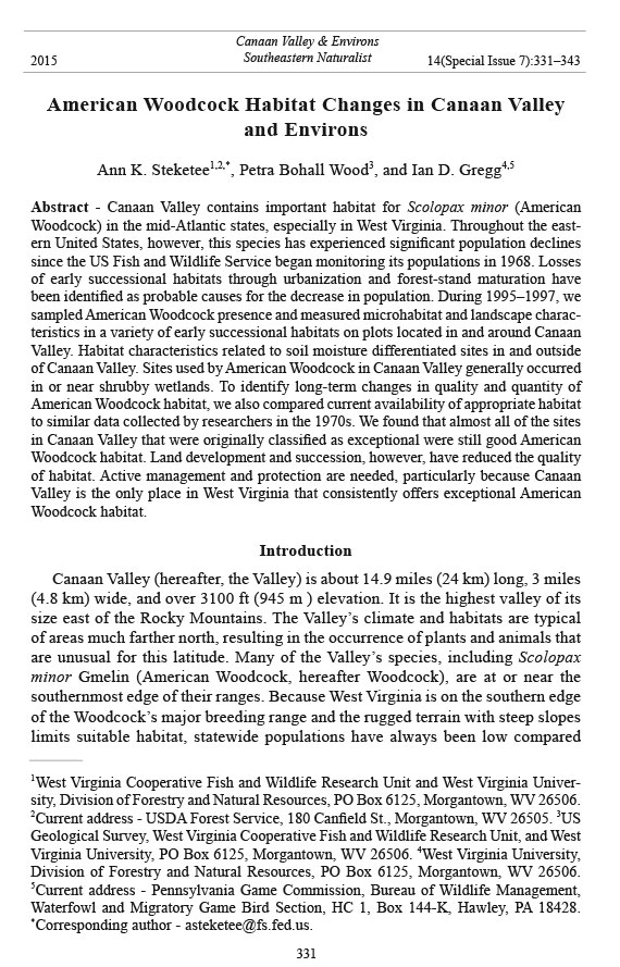
The study area included most of the Valley and selected sites in the nearby
counties of Preston, Randolph, Pendleton, Grant, and Tucker (Fig. 1). We
Southeastern Naturalist
A.K. Steketee, P. Bohall Wood, and I.D. Gregg
2015 Vol. 14, Special Issue 7
333
confined our searches to public lands and to private lands for which we obtained
written permission for access. We searched areas included in the 1970s studies,
areas that seemed to be likely Woodcock habitat, and areas suggested by local
hunters and WVDNR personnel.
Figure 1. Woodcock-flush points in and around Canaan Valley, WV. Some flush points are
close together, therefore symbols overlap.
Southeastern Naturalist
A.K. Steketee, P. Bohall Wood, and I.D. Gregg
2015 Vol. 14, Special Issue 7
334
Methods
Summary of the 1970s studies
Fenwood (1976) and Webb (1978) initially located potential habitat by examining
stereo pairs of 9.6 x 9.6-in (23 x 23-cm), black and white, 1:20,000-scale
aerial photographs to identify lowland shrubby areas and other suitable sites.
These researchers included only sites on level or near level ground because
they considered shrubby habitats on steep slopes to be too dry for Woodcock.
Fenwood (1976) and Webb (1978) determined approximate site area with a dot
grid, and they transferred the site outlines to the appropriate 7.5' or 15' US Geological
Survey (USGS) topographical map. They field-checked approximately
half of the sites for Woodcock signs, including presence of probings, splashes,
and flushed birds. Fenwood and Webb used their knowledge of the species to
place field-checked sites into one of four subjective quality categories—poor,
fair, good, exceptional—based on presence of Woodcock or their sign, site size,
percent ground cover, percent shrub density, soil moisture, land use, and reported
use. Using Fenwood’s (1976) and Webb’s (1978) data, we gave all sites not fieldchecked
a qualitative rating of questionable, possible, or probable Woodcock
habitat based on our interpretation of the aerial photographs. These categories
roughly corresponded to the poor, fair, and good ratings assigned to field-checked
sites (Fenwood 1976).
We identified 1261 potential woodcock habitat sites (~42,000 ac [~17,000
ha]) statewide. Of the 659 sites (30,394 ac [12,300 ha]) that were field-checked,
we rated only 124 (14,688 ac [5944 ha]) as good or exceptional. This represented
19% of the total number of sites and 48% of the area surveyed. All exceptional
sites (10 sites, 7695 ac [3114 ha]) were located in the Valley. We identified the
remaining 602 sites (11,438 ac [4629 ha]) on aerial photographs but we did not
field-check them. We classified only 160 sites (27%), containing 3207 ac (1298
ha) or 28% of the total acreage, as possible or probable Woodcock habitat.
1990s data collection
We initially located potential habitat in and around the Valley by using a
combination of expert opinion, resurveying sites from the 1970s survey, and by
examining aerial photographs. We field-checked sites identified as potential habitat
for the presence of Woodcock and their sign. We used a variety of methods
to determine Woodcock use, including searches with trained pointing or flushing
dogs. We used a global positioning system (GPS) to record the exact locations of
the Woodcock when dogs discovered them, and we entered the coordinates into
an Arc/Info geographic information system (ESRI 1996).
When we found a Woodcock, we collected non-scale-dependent habitat data,
including vegetation type, percent canopy closure, land use, and soil characteristics,
at the flush point and in the area immediately surrounding it (Steketee 2000).
We recorded characteristics considered to be important for Woodcock: height of
herbaceous vegetation; percent of herbaceous ground cover and litter cover; canopy
and shrub cover; shrub-stem density; and soil moisture, texture, and compaction
Southeastern Naturalist
A.K. Steketee, P. Bohall Wood, and I.D. Gregg
2015 Vol. 14, Special Issue 7
335
(Gutzwiller et al. 1983, McCoy 1987). In general, we used the methods described
by James and Shugart (1970) with slight modifications (Steketee 2000).
GIS analysis
Using ArcGIS software, we established two circular buffers with radii of 492
and 3937 ft (150 and 1200 m) around each flush point. Because of the 98 x 98-
ft (30 x 30-m) resolution of Landsat TM data, we chose 492 ft (150 m) as the
smallest practical buffer distance. We chose the greater distance because research
suggests that Woodcock make daily movements of up to 0.6 mi (1 km; Sepik and
Derleth 1993), and therefore, may be affected by and respond to habitat composition
at this scale.
We used the Multi-Resolution Land Characteristic (MRLC) database (Vogelmann
et al. 1996) and FRAGSTATS spatial analysis program (McGarigal and
Marks 1995) to quantify habitat variables within each point’s circular buffer. The
MRLC is a land-cover database for the entire mid-Atlantic region derived primarily
from the Land Remote Sensing Satellite (Landsat) Thematic Mapper data.
Because of its 98 x 98-ft (30 x 30-m) pixel resolution, the MRLC cannot be used
to identify long, narrow tracts like utility rights-of-way, secondary roads, lowerorder
rivers and streams, and all features smaller than 98 x 98 ft (30 x 30 m).
We calculated four landscape-level FRAGSTATS metrics: Shannon’s
diversity index (SDI), patch richness (PR), area-weighted mean patch fractaldimension
(AWMPFD), and mean shape index (MSI). We defined landscape as
the area within the circular buffer around each flush point, and the landscape
was composed of patches of the 12 MRLC land-cover categories. FRAGSTATS
landscape metrics quantify landscape composition or configuration. Landscape
configuration refers to the physical distribution of patches within the landscape.
Composition, which refers to the presence and amount of each patch type, is not
spatially explicit.
Landscape composition was quantified with two landscape-level metrics:
SDI and PR. SDI represents the probability that any two patches picked at random
will be different types. Thus, higher SDI values indicate greater diversity.
Because it is a probability, SDI places more weight on common patch types;
a single patch of a rare type contributes relatively little to the diversity index.
PR, which is sensitive to rare patch types, is simply the number of different
land-cover types present within a buffer. It provides no information on the
number or size of patches.
Landscape configuration was quantified with MSI and AWMPFD. MSI is a
measure of patch-shape complexity. When a patch is square, i.e., the simplest
patch shape, the MSI equals 1. MSI becomes larger with increasing patch-shape
complexity. AWMPFD, another measure of patch-shape complexity, approaches
a value of 1 for shapes with simple perimeters and approaches 2 as shapes become
more complex (McGarigal and Marks 1995). Because larger patches tend
to have more complex shapes than smaller patches, AWMPFD adjusts for patch
area and determines patch-shape complexity independent of size.
Southeastern Naturalist
A.K. Steketee, P. Bohall Wood, and I.D. Gregg
2015 Vol. 14, Special Issue 7
336
Results
During May–August 1995–1997, we identified 40 Woodcock-use points in the
Valley and 32 in surrounding areas (Fig. 1). Most of the Valley’s Woodcock-use
points (27 of 40) occurred in alder thickets, but outsidethe Valley only eight of
32 use points were in alder thickets.
1970s vs. 1990s habitat suitability
We rated the 1970s sites as a whole based on current conditions, although the
quality of each site may not have been uniform throughout. Some of the larger
sites had portions unsuitable for Woodcock but we still rated them as useable
habitat if the majority of the site was suitable or if Woodcock were found on part
of the site.
Fenwood (1976) and Webb (1978) identified 14,688 ac (5944 ha) of good and
exceptional habitat statewide. Most of the area (7692 ac [3113 ha]) was located
in the Valley, all of which was rated as exceptional. We identified an additional
1235 ac (500 ha) in the Valley as suitable for Woodcock. Our 1990s resurveys
indicated that almost all of the Valley sites (90.0% of sites, 95.1% of area) originally
classified as exceptional were still good Woodcock habitat. We classified
them as probable or definite habitat in the 1990s. We did not reclassify any previously
suitable sites as unlikely Woodcock habitat. Because we evaluated sites as a
whole and at least part of every 1970s site was still considered suitable Woodcock
habitat, it is difficult to quantify the amount of habitat that has been lost in the
Valley since the 1970s surveys.
Statewide, of the area originally rated as good or exceptional habitat in the
1970s, we rated 93.0% of it as definite Woodcock habitat. We confirmed that
sites classified as poor habitat in the 1970s were still unsuitable. We reclassified
only two sites as probable (8.0% of total site number, 49 ac [20 ha], 6.3%
of total area) that were originally classified as poor. We did not reclassify any
sites as definite. These two sites represented a small gain in suitable Woodcock
habitat, but this did not balance the loss in habitat statewide. Forty-four percent
of resurveyed sites and 19.4% of resurveyed area had become unsuitable for
Woodcock since the mid-1970s. Reasons for statewide habitat loss included
suburban and industrial development (6.6% of sites resurveyed); flooding due
to dams (1.1%); conversion to agricultural use (22%), e.g., open fields, pastures,
or row crops; and seral advancement of forest vegetation beyond what is
suitable for Woodcock (14.3%).
Microhabitat variables
Microhabitat characteristics of Woodcock-flush points in the Valley differed
from those in surrounding areas (Table 1). The Valley’s flush points featured
higher soil pH, moister soils, a greater percent of hydric soils, and closer proximity
to wetlands than flush points in surrounding areas. The Valley points also
supported greater shrub-stem density and a lower density of large trees. Flush
points in the Valley and surrounding areas did not differ in amount of herbaceous
Southeastern Naturalist
A.K. Steketee, P. Bohall Wood, and I.D. Gregg
2015 Vol. 14, Special Issue 7
337
plant cover or leaf-litter cover, although herbaceous plants at flush sites in the
Valley were not as tall as herbaceous plants at flush sites outside the Valley. Soil
texture and soil compaction did not differ between flush points inside and outside
of the Valley.
Landscape variables
In comparisons of flush points within and outside of the Valley at both buffer
scales (Table 2), all landscape variables except Shannon’s diversity index
differed. Flush sites in the Valley at both buffers had fewer (patch richness) and
larger patches than flush sites outside The Valley. Patch complexity (AWMPFD)
Table 1. Means of microhabitat variables measured at American Woodcock-flush sites in Canaan
Valley (n = 40) and surrounding areas (n = 32). Soil moisture is based on a scale of 1–3 where
1 = moist, 2 = medium, and 3 = dry. Soil texture is based on a scale of 1–3 where 1 = coarse, 2 =
medium, and 3 = fine. Soil compaction is based on a scale of 1–3 where 1 = difficult, 2 = medium,
and 3 = easy.
Canaan Valley Outside Canaan Valley
flushes flushes P > t
Soil pH 4.91 4.58 P < 0.001
Soil moisture 1.95 1.44 P < 0.003
Soil texture 2.05 2.07 P < 0.847
Soil compaction 1.95 2.26 P < 0.208
Hydric soil (%) 34.1 8.9 P < 0.001
Distance to wetland area (m) 38 311 P < 0.028
Elevation (m) 973 1009 P < 0.043
Shrub-stem density (#/ha) 1508 320 P < 0.053
Trees > 9m tall (#/ha) 18 210 P < 0.002
Leaf-litter cover (%) 73 61 P < 0.287
Herbaceous cover (%) 71 66 P < 0.554
Herbaceous height (cm) 25 37 P < 0.039
Table 2. Mean of landscape variables measured within a 150-m and a 1200-m buffer around American
Woodcock-flush sites in Canaan Valley (n = 40) and surrounding areas (n = 32).
Canaan Valley Outside Canaan Valley
flushes flushes P > t
150-m buffer
Patch richness 4.3 4.9 P < 0.022
Mean patch size (ha) 0.78 0.36 P < 0.026
Mean shape index 1.42 1.46 P < 0.066
Shannon’s diversity index 0.84 1.65 P < 0.218
Area weighted mean patch fractal dimension 1.35 1.37 P < 0.024
1200-m buffer
Patch richness 8.8 9.4 P < 0.043
Mean patch size (ha) 0.60 0.39 P < 0.001
Mean shape index 1.35 1.36 P < 0.040
Shannon’s diversity index 1.65 1.65 P < 0.495
Area weighted mean patch fractal dimension 1.40 1.43 P < 0.001
Southeastern Naturalist
A.K. Steketee, P. Bohall Wood, and I.D. Gregg
2015 Vol. 14, Special Issue 7
338
was lower for the Valley’s flush sites within both the 492- and 3937-ft (150- and
1200-m) buffers.
Discussion
Woodcock require wet woodlands with young forest embedded with scattered
openings (Sheldon 1967). Good habitat is generally defined as a dense, low,
shrubby canopy often associated with a meandering stream. Alder is generally
the most important shrub species present (Webb 1978, Webb and Samuel 1982).
Webb (1978) described a good quality habitat site in West Virginia as:
“… found in a gently sloping bottomland somewhere in the mountain
region and was 45 ac (18.2 ha) in size. It had been used as pastureland
sometime in the past but was now abandoned and shrubs were taking over;
alder had come in along a small stream and hawthorn was present on the
higher ground. The height of the shrub cover was variable, but was generally
9.8–20 ft (3–6 m); canopy closure also was variable but averaged
60%. Ground-cover density was intermediate and moisture content of the
soil was damp.”
This description is still applicable to Woodcock habitat in West Virginia (Steketee
2000), particularly in the Valley. Additionally, good but atypical habitat was
found in the vicinity of the Valley. For example, we found good habitat on the
Monongahela National Forest in young Acer pensylvanicum L. (Striped Maple)
and Crataegus spp. (hawthorn) stands sited on flat benches and ridge tops (Gregg
1997, Gregg et al. 2000, Steketee 2000,).
Our comparison of Woodcock sites within and outside the Valley suggests
that characteristics related to soil moisture are the primary differences between
them. Additionally, the Valley’s flush points were close to shrubby wetlands; 68%
of flush points, vs. only 25% of flush points outside the Valley, occurred directly
in shrubby wetlands, although this habitat type comprised less than 2% of the total land
area in the study area. This result indicates that Woodcock preferentially choose
shrubby wetlands. Distance to shrubby wetlands is a good predictor of Woodcock
presence in West Virginia (Steketee 2000). Woodcock are known to make heavy
use of wooded wetland areas, particularly those with alder (Sepik et al. 1989, Sheldon
1967), probably because they contain the moist, rich soils that harbor high
densities of earthworms (Parris 1986), the Woodcock’s primary food (Sheldon
1967). In heavily forested, mountainous areas, like West Virginia, these soil types
are largely limited to wetlands, riparian areas, and small, scattered seeps. Most
stream banks and riparian areas in the study area were, however, covered with forest
vegetation rather than shrubs, and thus may not have been used by Woodcock
(Webb and Samuel 1982). Woodcock in West Virginia are occasionally associated
with seeps or other damp areas too small to map with aerial photographs (Webb
1978) or satellite imagery (Steketee 2000).
Shrub-stem densities were higher in the Valley than in surrounding areas.
However, the 3770 stems/ac (1508 stems/ha) value we calculated for our study
Southeastern Naturalist
A.K. Steketee, P. Bohall Wood, and I.D. Gregg
2015 Vol. 14, Special Issue 7
339
area was well below the 25,000–125,000 stems/ac (10,000–50,000 stems/ha)
that Straw et al. (1994) indicated was typical and the 18,833–289,163 stems/ac
(7533–115,665 stems/ha) reported by Sepik et al. (1989). Because of these large
differences among the studies, Sepik et al. (1989) concluded that it is difficult to
recommend an optimal stem density for Woodcock. Many sites in West Virginia,
particularly those outside of the Valley, probably contain suboptimal shrubstem-
densities. High shrub-stem density moderates soil temperature, maintains
moisture for earthworms (Parris 1986, Reynolds et al. 1977), minimizes herbaceous
growth that would inhibit Woodcock access to worms (Sepik et al. 1989),
and provides cover to protect the birds from predators.
Although all of West Virginia is usually included in its breeding range, in-state
Woodcock habitat is limited in both its total acreage and distribution (Fenwood
1976, Steketee 2000, Webb 1978). Because of the state’s mountainous terrain,
there are virtually no large expanses of Woodcock habitat. Rather, large patches
of the shrubby lowland areas preferred by Woodcock are uncommon. Woodcock
habitat areas tends to be small, scattered, patchy, and often irregularly shaped
(Fenwood 1976, Steketee 2000, Webb 1978). The exception to this pattern is
in the Valley. Our landscape analysis indicated that sites used by The Valley’s
Woodcock contained fewer patch types and larger patch sizes than occurrences
outside the Valley. We expected this result because Woodcock prefer shrubby
wetlands, a habitat type found in large patches only in the Valley.
The Valley is the only place in West Virginia that contains large patches
of wetlands with the high shrub-stem densities and moist soils that Woodcock
require; these features appear to be relatively constant over time. Areas used
by Woodcock outside the Valley are highly variable and include some shrub
wetlands, but also regenerating timber cuts, reverting old fields, and reclaimed
surface mines. Some of these areas, although used by Woodcock, seem to be suboptimal.
For example, Gregg et al. (2003) found that although Woodcock used
reclaimed surface mines in West Virginia, many of these sites did not provide
ideal habitat due to inferior soils and/or insufficient stem densities. Moreover,
many areas of Woodcock habitat outside the Valley rapidly become unsuitable
due to forest succession. Ongoing management is necessary to create and maintain
habitat if net habitat losses are to be avoided.
Woodcock habitat is declining range-wide. Several researchers have associated
this loss with increasing amounts of urban/developed land and mature
forest stands, and with limited availability of regenerating stands dominated by
seedlings and saplings (Coulter and Baird 1982, Dwyer et al. 1983, Gutzwiller
et al. 1983, USFWS 1990). In our statewide habitat re-inventory, Steketee
(2000) reported that 35.9% of resurveyed sites and 19.4% of resurveyed area
became unsuitable for Woodcock from the mid-1970s to the 1990s because of
forest-stand succession and/or human causes including land development, agriculture,
and flooding.
Conversion to agricultural uses, like crops, open fields, and animal pasture,
accounted for the majority of sites and area lost during our statewide resurvey
Southeastern Naturalist
A.K. Steketee, P. Bohall Wood, and I.D. Gregg
2015 Vol. 14, Special Issue 7
340
(Steketee 2000). Lowlands and floodplains provide not only prime Woodcock
cover, but also an inviting location for urban or agricultural development. This
is especially true in West Virginia, where, because such lands are at a premium
(Kletzly 1976), humans have diverted much of this flat land for their own uses
(Webb 1978).
Statewide, forest-stand maturation and urban development were responsible
for 20.9% of the sites and 10.9% of the area lost as Woodcock habitat between the
1970s and our resurveys (Steketee 2000). Others have also connected forest-stand
succession and urbanization with a loss of Woodcock habitat. In Pennsylvania,
Gutzwiller et al. (1983) determined that increases in the amount of mature forest
(e.g., sawtimber with ≥1/2 trees of DBH > 11.7 in [27.9 cm]) and urban area were
consistent with an apparent decline of Woodcock populations. Dwyer et al. (1983)
analyzed habitats along SGS routes in the northeastern US and concluded that
declines in Woodcock numbers were related to increases in urban development.
Earlier researchers in West Virginia (Fenwood and Webb 1981, Kletzly 1976) noticed
and commented on a pattern of human encroachment into Woodcock habitat,
a trend that appears to be continuing. Forest-stand succession is also a factor in
Woodcock habitat loss. West Virginia’s forests have become increasingly mature
since the last major cutting cycle at the turn of the 19th–20th centuries (DiGiovanni
1990). Along SGS routes in West Virginia, Steketee et al. (2000) found that the
amount of mature deciduous forest increased as Woodcock counts decreased.
The Valley has historically contained the best habitat and largest Woodcock
populations in West Virginia (Goudy et al. 1970, Webb 1978, Webb and Samuel
1982). It is also an important migration staging area for the species (USFWS
1990). Within the Valley, Goudy et al. (1970) estimated that about 7900 ac (3200
ha) were suitable for Woodcock in the 1960s. In the 1970s, Fenwood (1976) and
Webb (1978) identified 7692 ac (3113 ha) of exceptional Woodcock habitat in
the Valley, and scored an additional 1235 ac (500 ha) as suitable. Our resurveys
in the 1990s indicated that almost all of the Valley’s sites (90.0% of sites, 95.1%
of area) originally classified as exceptional were still good Woodcock habitat.
However, Michael (1993) stated, “Woodcock habitat is rapidly disappearing
throughout the Valley as development and ecological succession affect many areas
that once supported large numbers of breeding and migrating Woodcock. It is
estimated that as many as 1300 Woodcock nested in the Valley during the 1960s
and 1970s. Although no recent estimates have been made, the resident population
has declined significantly, probably to fewer than 450 birds.” Michael (1993)
further stated that “prime Woodcock [breeding] habitat in the alder and aspen
stands … is presently somewhat overgrown at ground level [due to removal of
cattle grazing], while old-field and wet-meadow habitats used for courtship are
abundant in the Valley.”
Management Opportunities and Ecological Implications
Before extensive logging, the Valley’s plant communities were dominated by
large Picea rubens Sarg. (Red Spruce) with a dense understory of Rhododendron
Southeastern Naturalist
A.K. Steketee, P. Bohall Wood, and I.D. Gregg
2015 Vol. 14, Special Issue 7
341
maximum L. (Great Laurel). Natural openings or glades in this forest consisted
of dry grass balds or bogs that were too wet to support most tree species. Early
successional habitats likely occurred in small patches throughout the Valley
as a result of small-scale disturbances such as windthrows. Pre-settlement-era
Woodcock populations likely occurred in these small early-successional habitats.
Consequently, we speculate that Woodcock populations in the pre-logging
era were low. However, the generally moist, humus-rich acidic soil would have
provided ideal conditions for earthworms, the primary food of Woodcock.
Provision of adequate Woodcock habitat is imperative if the current negative
trend in the species’ populations is to be reversed. Given the relatively ephemeral
nature and sometimes suboptimal quality of some types of Woodcock habitat,
there is a particular need to identify, protect, and in many cases actively manage
areas that currently provide or are capable of providing stable, high-quality
Woodcock habitat. Sites used by Woodcock outside the Valley tend to be in earlysuccessional
habitat associated with regenerating clearcuts or reverting old fields,
and thus were suitable for a relatively short period. Alder thickets, however, such
as those found within the Valley, tend to persist for longer periods and provide a
more consistent habitat.
Currently, the Valley includes 40 different wetland and upland plant communities
(USFWS 1994) that provide a mix of habitat types. Although habitat
conditions may differ from those that were historically present, we believe that
protection and active management of Woodcock habitat in the Valley are high
priorities. The Valley is critically important to breeding and migrating Woodcock
and several of the currently available habitat types can be managed for
this declining species. The Canaan Valley National Wildlife Refuge now has
over 15,000 acres (6070 ha), which includes most of the Woodcock’s available
habitat (Ken Sturm, USFWS, pers. comm.). Refuge lands are protected from development
and provide numerous opportunities for managing early successional
habitats, which will benefit not only Woodcock but also many other plant and
animal species (Denmon 1998).
Literature Cited
Coulter, M.W., and J.C. Baird. 1982. Changing forest land-uses and opportunities for
Woodcock management in New England and the Maritime Provinces. Pp. 75–85, In
T.J. Dwyer and G.L. Storm (Technical Coordinators). Proceedings of the Seventh
Woodcock Symposium. US Fish and Wildlife Research Report 14. Washington, DC.
Denmon, P. 1998. Early-successional habitat use by nongame wildlife species in American
Woodcock breeding habitat in West Virginia. M.Sc. Thesis. West Virginia University,
Morgantown, WV. 120 pp.
DiGiovanni, D.M. 1990. Forest statistics for West Virginia 1975 and 1989. US Department
of Agriculture, Forest Service Resource Bulletin NE114, Radnor, PA. 28 pp.
Dwyer, T.J., D.G. McAuley, and E.L. Derleth. 1983. Woodcock singing-ground counts
and habitat changes in the northeastern United States. Journal of Wildlife Management
47:772–779.
ESRI. 1996. The Arc/Info Geographic Information System, Version 7.1. Redlands, CA.
Southeastern Naturalist
A.K. Steketee, P. Bohall Wood, and I.D. Gregg
2015 Vol. 14, Special Issue 7
342
Fenwood, J.D. 1976. An inventory of Woodcock habitat in southern West Virginia. M.Sc.
Thesis. West Virginia University, Morgantown, WV. 110 pp.
Fenwood, J.D., and L.O. Webb. 1981. An aerial photo inventory of Woodcock habitat in
West Virginia. Wildlife Society Bulletin 9:306–307.
Goudy, W.H., R.C. Kletzly, and J.C. Rieffenberger. 1970. Characteristics of a heavily
hunted Woodcock population in West Virginia. Transactions of the North American
Wildlife and Natural Resources Conference 35:183–195.
Gregg, I.D. 1997. American Woodcock use of reclaimed surface mines in West Virginia.
M.Sc. Thesis. West Virginia University, Morgantown, WV. 112 pp.
Gregg, I.D., P.B. Wood, and D.E. Samuel. 2000. American Woodcock use of reclaimed
surface mines in West Virginia. Pp. 9–22, In D.G. McAuley, J.G. Bruggink, and G.F.
Sepik (Eds.). Proceedings of the Ninth American Woodcock Symposium. US Geological
Survey, Biological Resources Division Information and Technology Report
USGS/BRD/ITR-2000-0009, Patuxent Wildlife Research Center, Laurel, MD.
Gregg, I.D., P.B. Wood, and A K. Steketee. 2003. Comparison of reclaimed and unmined
Woodcock diurnal habitat in West Virginia. Proceedings of the Annual Conference of
the Southeast Association of Fish and Wildlife Agencies 55: 488–497.
Gutzwiller, K.J., and J.S. Wakeley. 1982. Differential use of Woodcock singing-grounds
in relation to habitat characteristics. Pp. 51–54, In T.J. Dwyer and G.L. Storm (Technical
Coordinators). Woodcock ecology and management. US Fish and Wildlife Service
Wildlife Research Report 14, Washington, DC.
Gutzwiller, K.J., K.R. Kinsley, G.L. Storm, W.M. Tzilkowski, and J.S. Wakeley. 1983.
Relative value of vegetation structure and species composition for identifying American
Woodcock breeding habitat. Journal of Wildlife Management 47:535–540.
James, F.C., and H.H. Shugart, Jr. 1970. A quantitative method of habitat description.
Audubon Field Notes 24:727–736.
Kelley, J.R., Jr. 2001. American Woodcock population status, 2001. US Fish and Wildlife
Service, Laurel, MD. 20 pp
Kletzly, R.C. 1976. American Woodcock in West Virginia. West Virginia Division of
Natural Resources Bulletin No. 8, Charleston, WV.
McCoy, R.W. 1987. PAM HEP habitat suitability index model for Woodcock. US Fish
and Wildlife Service, State College, PA. 4 pp.
McGarigal, K., and B.J. Marks. 1995. FRAGSTATS: Spatial pattern analysis program
for quantifying landscape structure. General Technical Report PNWGTR351. USDA
Forest Service, Pacific Northwest Research Station, Portland, OR . 122 pp.
Michael, E. 1993. An evaluation including southern Canaan Valley in the proposed
Canaan Valley National Wildlife Refuge. Report submitted to US Fish and Wildlife
Service and US Environmental Protection Agency.
Parris, R.W. 1986. Forest vegetation, earthworm, and Woodcock relationships. Ph.D.
Dissertation. State University of New York, Syracuse, NY. 240 pp.
Reynolds, J.W., W.B. Krohn, and G.A. Jordan. 1977. Earthworm populations as related
to Woodcock habitat usage in central Maine. Proceedings of the Sixth Woodcock
Symposium 6:13–146.
Sepik, G.F., and E.L. Derleth. 1993. Habitat use, home-range size, and patterns of moves
of the American Woodcock in Maine. Pp. 41–49, In J.R. Longcore and G.F. Sepik
(Eds.). Proceedings of the Eighth Woodcock Symposium. US Fish and Wildlife Service
Biological Report 16. Washington, DC.
Southeastern Naturalist
A.K. Steketee, P. Bohall Wood, and I.D. Gregg
2015 Vol. 14, Special Issue 7
343
Sepik, G F., R.B. Owen, Jr., T.J. Dwyer, and E.L. Derleth. 1989. Habitat requirements
and management of Woodcock in the Northeast: Assessment of knowledge and needs.
Pp. 97–109, In J.C. Finley and M.C. Brittingham (Eds.). Timber management and its
effects on wildlife. Proceedings of the 1989 Pennsylvania state forest resources issues
conference, University Park, PA.
Sheldon, W.G. 1967. Book of the American Woodcock. University of Massachusetts
Press, Amherst, MA. 250 pp.
Steketee, A.K. 2000. Predicting habitat suitability for American Woodcock and landscape-
level assessment of habitat in West Virginia. Ph.D. Dissertation. West Virginia
University, Morgantown, WV. 132 pp.
Steketee, A.K., P.B. Wood, J.G. Bruggink, D.E. Samuel, and J.I. Cromer. 2000. Land-use/
land-cover changes along Woodcock singing-ground survey routes in West Virginia.
Pp. 107–116, In D.G. McAuley, J.G. Bruggink, and G.F. Sepik (Eds.). Proceedings
of the Ninth American Woodcock Symposium. US Geological Survey, Biological
Resources Division Information and Technology Report USGS/BRD/ITR-2000-0009,
Patuxent Wildlife Research Center, Laurel, MD.
Straw, J.A., D.G. Krementz, M.W. Olinde, and G.F. Sepik. 1994. American Woodcock.
Pp. 97–114, In T.C. Tacha and C.E. Braun (Eds.). Migratory shore and upland gamebird
management in North America. International Association of Fish and Wildlife
Agencies, Washington, DC.
United States Fish and Wildlife Service (USFWS). 1979. Final environmental impact
statement: Acquisition of lands for the Canaan Valley National Wildlife Refuge West
Virginia. US Department of the Interior, Washington, DC. 20 pp.
USFWS. 1990. American Woodcock management plan. US Fish and Wildlife Service,
Washington, DC. 11 pp.
USFWS. 1994. Canaan Valley National Wildlife Refuge Station management plan. US
Fish and Wildlife Service, Region 5. Hadley, MA.
Vogelmann, J.E., S.M. Howard, and T. Sohl. 1996. Regional landcover characterization
using multiple sources of intermediate-scale data. Proceedings 1996 International
Geoscience and Remote Sensing Symposium 1:246–247.
Webb, L.O. 1978. Woodcock habitat inventory of northern West Virginia using aerial
photographs. M.Sc. Thesis. West Virginia University, Morgantown, WV. 61 pp.
Webb, L.O., and D.E. Samuel. 1982. Woodcock habitat inventory and wetlands in northern
West Virginia. In B. McDonald (Ed.). Proceedings of a Symposium on Wetlands
of the Unglaciated Appalachian Region, Morgantown, WV.


 The Southeastern Naturalist is a peer-reviewed journal that covers all aspects of natural history within the southeastern United States. We welcome research articles, summary review papers, and observational notes.