D.J. Eisenhour and M.A. Floyd
2013 Southeastern Naturalist
82
Vol. 12, Special Issue 4
A Culvert Acts as a Barrier for Blackside Dace (Chrosomus
cumberlandensis) Movements in Lick Fork, Kentucky
David J. Eisenhour1,* and Michael A. Floyd2
Abstract - From 2003 to 2012, we surveyed the fishes of Lick Fork, a Blackside Dace
(Chrosomus cumberlandensis) stream in Bell County, KY. The downstream half of
Lick Fork flows through a subdivision, where it is interrupted by a perched culvert that
restricts the movement of fishes within Lick Fork. The fish faunas and abundance of
Blackside Dace upstream and downstream of the culvert were strikingly different. Downstream
of the culvert, the fish fauna was species-rich (9–13 species), KIBI scores were
high (48–56, considered “Good” to “Excellent”), and Blackside Dace were common. In
contrast, upstream of the culvert Blackside Dace were rare, only two species—Semotilus
atromaculatus (Creek Chub) and Rhinichthys atratulus (Blacknose Dace)—were
found in abundance, and KIBI scores were lower (33–48, considered “Fair” to “Good”).
Comparison with historical collections (1994) revealed declines or extirpations of some
fishes (Chrosomus and Etheostoma) upstream of the culvert. The striking difference in
the upstream and downstream faunas and the decline of some fish species, including
Blackside Dace, is likely due to upstream extirpations from droughts or other stochastic
events, coupled with the inability to recolonize from downstream populations because of
the culvert barrier. This conclusion suggests that bridge and culvert design and placement
are important considerations in management of Blackside Dace streams, as they can have
a significant effect on community composition and fish movement.
Introduction
Chrosomus cumberlandensis (Blackside Dace) is a small minnow (family
Cyprinidae) restricted to headwater streams in the upper Cumberland River
drainage in Kentucky and Tennessee. Typically, Blackside Dace occur in streams
that are cool, silt-free, and shaded by dense canopy cover. Coal mining, logging,
urbanization, and other watershed disturbances have resulted in the decline or extirpation
of several populations of Blackside Dace (Eisenhour and Strange 1998).
The species has been designated as threatened in Kentucky (KSNPC 2010) and
Tennessee (Withers 2009) and has also been federally listed as threatened (USFWS
1987). Although numerous populations of Blackside Dace are known (Black
et al. 2013 [this issue], Laudermilk and Cicerello 1998, O’Bara 1990), most populations
are small and restricted to short (1–6 km) reaches of headwater streams
(Starnes and Starnes 1978). These headwater habitats are particularly affected
by natural stochastic events (e.g., drought and floods) and anthropogenic events
(e.g., siltation, warming, or acidification following watershed disturbances) that
can lead to local population extirpations. Barriers that eliminate connectivity
among populations represent a threat because they do not allow recolonization
1Department of Biology and Chemistry, Morehead State University, Morehead, KY
40351, 2US Fish and Wildlife Service, Frankfort, KY 40601 *Corresponding author -
d.eisenhour@morehead-st.edu.
Ecology and Conservation of the Threatened Blackside Dace, Chrosomus cumberlandensis
2013 Southeastern Naturalist 12(Special Issue 4):82–91
83
D.J. Eisenhour and M.A. Floyd
2013 Southeastern Naturalist Vol. 12, Special Issue 4
of depopulated areas and can contribute to the isolation of populations. Road
crossings of streams (often associated with culverts) are potential barriers to fish
migrations and can increase predation, particularly when the downstream end of
a culvert is perched above the streambed (Benton et al. 2008, Schaefer et al. 2003,
Warren and Pardew 1998, Winston 2002).
The fish community of Lick Fork was first surveyed in 1994 by Laudermilk and
Cicerello (1998), who documented a total of 15 species, including Blackside Dace
and 2 darter species, Etheostoma kennicotti (Stripetail Darter) and Etheostoma sagitta
(Cumberland Arrow Darter), a Candidate for Federal listing (USFWS 2012)
(Fig. 1). We surveyed the fishes of Lick Fork from 2003–2012 as part of baseline
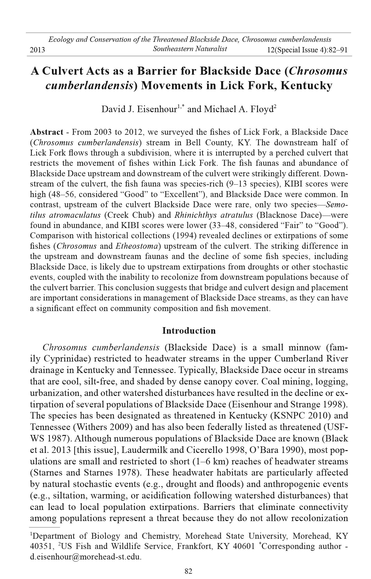
Figure 1. Map of Lick Fork, Bell County, KY. Arrows identify locations, dates, and numbers
of individuals of Blackside Dace captured in Lick Fork from 2003–2012. The 1994
records are from Laudermilk and Cicerello (1998).
D.J. Eisenhour and M.A. Floyd
2013 Southeastern Naturalist
84
Vol. 12, Special Issue 4
surveys associated with a surface coal-mine permit. Through completion of these
surveys, we have been able to document changes in fish diversity and community
composition in Lick Fork. This study examines the effect of a perched culvert on
fish community composition in Lick Fork, and evaluates the culvert’s effect on the
conservation status of Blackside Dace.
Field-site Description
Lick Fork is a first-order, high-gradient tributary of Yellow Creek Bypass, a
modified and constructed extension of Bennetts Fork (Fig. 1). Lick Fork is approximately
4.6 km long and drains an area of 7.8 km2. Channel widths range
from 1–4 m, and substrates are composed primarily of boulder and cobble, with
lesser amounts of bedrock and gravel. Large woody debris is common throughout
the system. The upper half of the Lick Fork watershed is densely forested, with
extensive canopy cover (90–100%) and wide riparian zones (Fig. 2A). Although
surface coal mining has occurred in the headwaters of Lick Fork, siltation is low,
and stream conductivity values are at baseline levels (less than 100 uS/ cm).
The downstream 1.8 km of Lick Fork flows through a subdivision (Ambleside)
at the northern edge of Middlesboro, in Bell County, KY. Within this
reach, riparian vegetation is limited to narrow bands of trees or lawn grasses.
Figure 2. Lick Creek, Bell County. A. About 400 m above culvert (stream was dry during
severe drought, 4 November 2007); B. About 100 m below culvert, 22 October 201 1; C.
Culvert at Windermere Road crossing, 25 October 2008; D. Recently channelized area
just above culvert, 22 October 2011.
85
D.J. Eisenhour and M.A. Floyd
2013 Southeastern Naturalist Vol. 12, Special Issue 4
Bottom substrates are finer, with greater amounts of gravel, although cobble
and boulder remain as the dominant substrates in most of this reach (Fig. 2B).
Within the subdivision, Lick Fork has been relocated, channelized, and is
interrupted by two road crossings. The most upstream road crossing (Windermere
Road) was constructed in 1988 and is located about 1.6 km upstream of
the mouth. This crossing consists of two large pipes (culverts), each about 1.5
m in diameter (Fig. 2C). At the downstream end of the pipes, Lick Fork drops
about 0.8 m into a large pool. Within the subdivision, Lick Fork is generally
entrenched, with eroded and unstable banks; however, these conditions are less
severe immediately downstream of the perched culvert and have not greatly
affected the streambed (Fig. 2B). The 200-m reach upstream of the culvert
is degraded, consisting mostly of a homogenous gravel-cobble run that lacks
pools (Fig. 2D). This condition was created by the culvert acting as a gradecontrolling
structure and reducing the upstream gradient, and subsequently,
channelization and gravel removal.
During our surveys, Lick Fork had perennial flow from its mouth to a point
300 m upstream of the culvert. Upstream of this point, flow ceased during periods
of severe drought (Fall 2006–2008) (Fig. 2A). In 2007, the driest year, some
water remained in isolated pools, but the streambed was completely dry upstream
of a point 450 m above the culvert.
Methods
Lick Creek was sampled each autumn from 2003–2012. Surveys were
completed upstream of the culvert during all sampling years, and were completed
downstream of the culvert in 2003 and from 2008–2012. We sampled
a 300-m reach downstream of the culvert (36.63909°N, 83.73691°W at the
downstream end) and a 1700-m reach upstream of the culvert (36.65276°N,
83.74770°W at the upstream end) (Fig. 1). In general, collection methods and
data analyses followed Kentucky Division of Water guidelines (Compton et al.
2003; KDOW 2008, 2010). Fishes were sampled with a backpack electrofisher
(Smith-Root LR-24), moving in an upstream direction. For the years when effort
was quantified, total shocking seconds ranged from 1533 to 9760 (mean
= 6003). Fewer shocking seconds were recorded in drought years, when long
stretches of upper Lick Fork were dry. Stunned fishes were captured, retained
live in buckets, identified, counted, and released. Fish community health was
evaluated using the Kentucky Index of Integrity (KIBI; Compton et al. 2003).
Scientific and common names follow Nelson et al. (2004), except for cases
where elevation of subspecies is not based on published systematic studies
(i.e., we use Rhinichthys atratulus [Blacknose Dace]).
Results
The fish communities of Lick Fork upstream and downstream of the culvert
were strikingly different. Upstream of the culvert, only two fish species,
Semotilus atromaculatus (Creek Chub) and Blacknose Dace, were common
D.J. Eisenhour and M.A. Floyd
2013 Southeastern Naturalist
86
Vol. 12, Special Issue 4
(Table 1). The two remaining species observed upstream of the culvert, Blackside
Dace and Stripetail Darter, were common in early samples, but subsequently
were captured infrequently. Downstream of the culvert, we observed a total of
16 species (range = 9–13), and Stripetail Darters and Blackside Dace were fairly
common throughout the sampling period.
Recent (2007–2012) collections upstream of the culvert had relatively low
KIBI scores (range = 33–40, mean = 36.5), corresponding to a rank of “Fair”.
Earlier collections (2003–2006) from the same area had higher KIBI scores
(range = 43–48, mean = 45.3), ranked as “Fair” to “Good”. Lower scores in
recent years primarily reflect an increased percentage of Blacknose Dace (considered
a “tolerant” and “facultative headwater” species by the KIBI; Compton et al.
2003), and, secondarily, reduced numbers of Blackside Dace and Stripetail Darters.
In contrast, KIBI scores from collections downstream of the culvert (range =
48–56, mean = 51.2) ranked the fish community as “Good” or “Excellent”.
Upstream of the culvert, Blackside Dace were common in 2003, but only
three individuals have been collected since that time—one juvenile in 2004, and
one adult each in 2008 and in 2011 (Table 1). Blackside Dace remained common
below the culvert, and multiple age classes were present during most years,
indicating ongoing, successful reproduction and recruitment. As documented by
the 1994 and 2003 collections, the most downstream segment of Lick Fork (near
the mouth) had few Blackside Dace and instead was dominated by tolerant and
non-native fishes (Table 1). This finding suggests the Blackside Dace population
in Lick Fork is generally confined to a 300–1000 m stream segment located
just downstream of the culvert. The few individuals of Blackside Dace captured
above the culvert may represent a small, remnant population or waifs that have
migrated upstream through the culvert. At present, we favor the former explanation
because no other species confined to areas downstream of the culvert have
been able to colonize the upstream portion, even after recent fl ood events.
Discussion
The culvert as a barrier
The fish community upstream of the culvert has declined, as evidenced by the
loss of one Federal Candidate species, Cumberland Arrow Darter, and decline of
two other species, Blackside Dace and Stripetail Darter (Table 1). Strikingly different
faunas occur upstream and downstream of the culvert. Although the first 200-m
section upstream of the culvert has been channelized, Lick Fork had little apparent
anthropogenic disturbance upstream of this area (Fig. 2A). Because Blackside
Dace were common within this reach in 1994 (Laudermilk and Cicerello 1998) and
in 2003, habitat degradation does not appear to be the primary reason for long-term
decline of Blackside Dace. Rather, we assert that recent poor KIBI scores and lower
abundance of Blackside Dace observed in the upstream reach are likely a result
of the road culvert at Windermere Drive acting as a fish passage barrier, preventing
recolonization following stochastic extirpation events.
It seems probable that populations of Blackside Dace and some other fishes
87
D.J. Eisenhour and M.A. Floyd
2013 Southeastern Naturalist Vol. 12, Special Issue 4
Table 1. Summary of fishes collected in Lick Fork, Bell County , KY 1994–2012.
Fish family or species 1994A 2003B 2004 2005 2006 2007 2008 2009 2010 2011 2012
Upstream of culvert
Chrosomus cumberlandensis (Starnes and Starnes) 11 8 1 1 1
Blackside Dace
Rhinichthys atratulus (Hermann) Many 95 92 169 164 174 234 147 310 887 316
Blacknose Dace
Semotilus atromaculatus (Mitchill) Many 118 346 581 375 164 212 158 730 375 304
Creek Chub
Lepomis auritus (L.) 1
Redbreast Sunfish
Etheostoma sagitta (Jordan and Swain) 3
Cumberland Arrow Darter
Etheostoma kennicotti (Putnam) 6 7 5 6 2 2 1
Stripetail Darter
Total individuals - 228 444 757 539 339 449 308 1040 953 620
Total species 5 4 4 2 2 3 3 2 2 4 2
KIBI score - 43 47 48 43 33 40 36 37 40 33
KIBI rating - Fair Good Good Fair Fair Fair Fair Fair Fair Fair
Downstream of culvert
Campostoma anomalum (Rafinesque) 5 20 36 66 32 185 140 265
Central Stoneroller
Chrosomus cumberlandensis 1 5 4 4 12 4 11
Luxilus chrysocephalus Rafinesque 52 2 12 3 60 26 41
Striped Shiner
Notropis buccatus (Cope) 2 8 6 6
Silverjaw Minnow
Pimephales notatus (Rafinesque) Many 409 2 1 1 9
Bluntnose Minnow
Pimephales promelas Rafinesque 2
Fathead Minnow
Rhinichthys atratulus 5 1 91 138 65 111 213 289
D.J. Eisenhour and M.A. Floyd
2013 Southeastern Naturalist
88
Vol. 12, Special Issue 4
Table 1, continued.
Fish family or species 1994A 2003B 2004 2005 2006 2007 2008 2009 2010 2011 2012
Semotilus atromaculatus Many 30 42 40 36 103 79 144
Catostomus commersonii (Lacepède) Many 10 1 1 18 7 1
White Sucker
Hypentelium nigricans (Lesueur) 3 1 4 3 1
Northern Hog Sucker
Ameiurus melas (Rafinesque) 2
Black Bullhead
Gambusia affinis (Baird and Girard) 1
Western Mosquitofish
Ambloplites rupestris (Rafinesque) 2
Rock Bass
Lepomis auritus 2 28 1 2 2 6 7 3
Lepomis cyanellus Rafinesque 1 2
Green Sunfish
Lepomis gulosus (Cuvier) 2 1
Warmouth
Lepomis macrochirus Rafinesque 9
Bluegill
Lepomis megalotis (Rafinesque) Many
Longear Sunfish
Micropterus punctulatus (Rafinesque) 2
Spotted Bass
Etheostoma caeruleum Storer 5 2 13
Rainbow Darter
Etheostoma kennicotti 1 9 9 19 45 52 30
Total individuals - 561 190 273 161 558 538 906
Total species 15 10 10 9 9 13 10 13
KIBI score - 33 49 48 49 56 54 53
KIBI rating - Fair Good Good Good Excel Good Good
ADownstream collection was about 1.5 km below culvert, 36.63000° N, 83.73556°W (Laudermilk and Cicerello 1998).
BDownstream collection was about 1 km below culvert, 36.63402°N, 83.73557°W.
89
D.J. Eisenhour and M.A. Floyd
2013 Southeastern Naturalist Vol. 12, Special Issue 4
exhibited metapopulation dynamics (Matthews 1998) in Lick Fork prior to culvert
construction. Historically, upstream reaches depopulated during natural
stochastic events (e.g., droughts) could have been recolonized from populations
in downstream reaches of Lick Fork or neighboring tributaries once favorable
flow conditions returned. Detar and Mattingly (2013 [this issue]) documented
impressive dispersal abilities of Blackside Dace in other streams—some marked
individuals moved up to 4 km, and one individual moved between two tributaries
separated by impounded waters of Lake Cumberland.
At low flows, the culvert is an impassible barrier because of its “perched”
position. During high flows (e.g., June 2011), the culvert is probably impassible
because of high water velocities in the pipes. Historically, the stream segment
upstream of the culvert likely served as a refugium for Blackside Dace and other
fishes during droughts, but it is now the most heavily damaged segment. Three
hundred meters of Lick Fork upstream of the culvert have perman ent flow, but a
200-m section of it is highly degraded (due to recent channelization activity) and
lacks pools. Thus, habitat degradation likely intensified the effects of droughts
and other natural events that caused upstream fish extirpations or population declines.
These events often are infrequent, apparently explaining the 15-year span
between construction of the Lick Fork culvert and the decline of the upstream
Blackside Dace population.
Recolonization of streams by fishes is most strongly influenced by the mobility
and size of the source population (Albanese et al. 2009). The number of potential
colonizers within the Yellow Creek basin has been reduced by water-quality
degradation (e.g., impacts from surface coal mining and logging) and physical
alterations such as channelization of streams surrounding Middlesboro. The Lick
Fork culverts decrease dace mobility to nearly zero, and recent extirpation of
Blackside Dace in an adjacent tributary, Stevenson Branch, also reduces the number
of potential colonizers. Extirpation in Stevenson Branch (to the west) appears
to be due to channelization of the lower reaches, coupled with untreated sewage
inputs and sedimentation impacts from logging in the headwaters. Benton et al.
(2008), Schaefer et al. (2003), Warren and Pardew (1998), and Winston (2002)
documented reduced or no upstream movement of fishes through culverts or local
extirpations in small streams. Fishes easily navigated natural barriers such
as small waterfalls and high-gradient riffles in these streams. Upstream extirpations
have been reported for small-stream fishes following construction of dams
and culverts (Winston 2002, Winston et al. 1991). Morita and Yamamoto (2002)
found that populations of Salvelinus leucomaensis (Palla) (White-spotted Char)
upstream of dams were more prone to extinction if the drainage area inhabited
was small, as is true for all Blackside Dace populations.
Conservation implications
Blackside Dace typically occupy short reaches of headwater streams, making
them especially vulnerable to events that reduce or eliminate local populations.
Loss of connectivity, either within a Blackside Dace stream or between Blackside
Dace streams, increases the risk of local extirpations. We suggest that free
D.J. Eisenhour and M.A. Floyd
2013 Southeastern Naturalist
90
Vol. 12, Special Issue 4
passage of Blackside Dace should be incorporated into any design when crossings
are placed in Blackside Dace streams. Fish community richness in Mill
Branch, a Blackside Dace stream in Knox County, KY, increased following replacment
of a perched culvert (Floyd et al. 2013 [this issue]). Replacement of the
Windermere Drive culvert with a “fish-friendly” crossing, coupled with habitat
restoration just upstream of the bridge, should be considered as a means of producing
a more stabile, larger population of Blackside Dace in Lick Fork.
Acknowledgments
Field assistance was provided by B. Boggs, S. Emeterio, T. Evans, S. Fryman, A.
Hunley, B. Huron, E. McCubbins, V. Middleton, C. Richardson, A. Richter, J. Schiering,
M. Seebold, R. Umbstead, and R. Wilder. Ed Hartowicz provided background
information on Ambleside Subdivision. Field surveys were completed for Appolo Fuels,
Inc. while the authors worked for Third Rock Consultants, LLC (2003, M. Floyd)
or Technical Water Labs (2004–2012, D. Eisenhour). Permits to collect fishes and
work with live vertebrates were provided by the US Fish and Wildlife Service (Southeast
Region, Atlanta, GA), the Kentucky Department of Fish and Wildlife Resources,
Frankfort, KY, and Morehead State University Institutional Animal Care and Use
Committee, Morehead, KY.
Disclaimer
The findings and conclusions in this article are those of the authors and do not necessarily
represent the views of the US Fish and Wildlife Service.
Literature Cited
Albanese, B., P.L. Angermeir, and J.P. Peterson. 2009. Does mobility explain variation
in colonisation and population recovery among stream fishes? Freshwater Biology
54:1444–1460.
Benton, P.D., W.E. Ensign, and B.J. Freeman. 2008. The effect of road crossings on fish
movements in small Etowah Basin streams. Southeastern Naturalis t 7:301–310.
Black, T.R., J.E. Detar, and H.T. Mattingly. 2013. Population densities of the threatened
Blackside Dace, Chrosomus cumberlandensis, in Kentucky and Tennessee. Southeastern
Naturalist 12(Special Issue 4):6–26.
Compton, M.C., G.J. Pond, and J.F. Brumley. 2003. Development and application of the
Kentucky Index of Biotic Integrity (KIBI). Kentucky Department of Environmental
Protection, Division of Water, Frankfort, KY. 45 pp.
Detar, J.E., and H.T. Mattingly. 2013. Movement patterns of the threatened Blackside
Dace, Chrosomus cumberlandensis, in two Southeastern Kentucky watersheds.
Southeastern Naturalist 12(Special Issue 4):64–81.
Eisenhour, D.J., and R.M. Strange. 1998. Threatened fishes of the world: Phoxinus cumberlandensis
Starnes & Starnes, 1978 (Cyprinidae). Environmental Biology of Fishes
51:140.
Floyd, M.A., S.L. Harrel, A.C. Parola, C. Hansen, J.B. Harrel, and D.K. Merrill.
2013. Restoration of stream habitat for Blackside Dace, Chrosomus cumberlandensis,
in Mill Branch, Knox County, Kentucky. Southeastern Naturalist 12(Special
Issue 4):129–142.
91
D.J. Eisenhour and M.A. Floyd
2013 Southeastern Naturalist Vol. 12, Special Issue 4
Kentucky Division of Water (KDOW). 2008. Methods for assessing biological integrity
of surface waters. Kentucky Department of Environmental Protection, Division of
Water, Frankfort, KY. 237 pp.
KDOW. 2010. Collection methods for fishes in wadeable streams, version 2.1. Kentucky
Department for Environmental Protection, Division of Water, Frankfort, KY. 13 pp.
Kentucky State Nature Preserves Commission (KSNPC). 2010. Rare and extirpated biota
of Kentucky. Journal of the Kentucky Academy of Science 71:67–81.
Laudermilk, E.L., and R.R. Cicerello. 1998. Upper Cumberland River drainage, Kentucky
fish collection catalog (1982–1994). KSNPC, Frankfort, Ken tucky. 469 pp.
Matthews, W.J. 1998. Patterns in Freshwater Fish Ecology. Chapman and Hall, New
York, NY. 756 pp.
Morita, K., and S. Yamamoto. 2002. Effects of habitat fragmentation by damming
on the persistence of stream-dwelling char populations. Conservation Biology
16:1318–1323.
Nelson, J.S., E.J. Crossman, J. Espinosa-Pérez, L.T. Findley, C.R. Gilbert, R.N. Lea, and
J.D. Williams. 2004. Common and scientific names of fishes from the United States,
Canada, and Mexico, 6th Ed. American Fisheries Society Special Publication 29,
Bethesda, MD. 386 pp.
O’Bara, C.J. 1990. Distribution and ecology of the Blackside Dace, Phoxinus cumberlandensis
(Osteichthyes: Cyprinidae). Brimleyana 16:9–15.
Schaeffer, J.F., E. Marsh-Matthews, and D.E. Spooner. 2003. Effects of barriers and thermal
refugia on local movement of the threatened Leopard Darter, Percina pantherina.
Environmental Biology of Fishes 66:391–400.
Starnes, W.C., and L.B. Starnes. 1978. A new cyprinid of the genus Phoxinus endemic to
the Upper Cumberland River drainage. Copeia 1978:50–516.
US Fish and Wildlife Service (USFWS). 1987. Endangered and threatened wildlife and
plants; determination of threatened species status for the Blackside Dace. Federal
Register 52:22,580–22,585.
USFWS. 2012. Endangered and threatened wildlife and plants; review of native species
that are candidates for listing as endangered or threatened: annual notice of findings
on resubmitted petitions: annual description of progress on listing actions; notice of
review. Federal Register 77:69,994-70,064.
Warren, M.L. Jr., and M.G. Pardew. 1998. Road crossings as barriers to small-stream fish
movement. Transactions of the American Fisheries Society 127:637–644.
Winston, M.R. 2002. Distribution and abundance of the Goldstripe Darter (Etheostoma
parvipinne) in Missouri. Southwestern Naturalist 47:187–194.
Winston, M.R., C.M. Taylor, and J. Pigg. 1991. Upstream extirpation of four minnow
species due to damming of a prairie stream. Transactions of the American Fisheries
Society 120:98–105.
Withers, D.I. 2009. A guide to the rare animals of Tennessee. Tennessee Department of
Environment and Conservation, Nashville, TN. 61 pp.


 The Southeastern Naturalist is a peer-reviewed journal that covers all aspects of natural history within the southeastern United States. We welcome research articles, summary review papers, and observational notes.