Distribution of the Armored Snail (Marstonia pachyta) and
Slender Campeloma (Campeloma decampi) in Limestone,
Piney, and Round Island Creeks, Alabama
Thomas M. Haggerty and Jeffrey T. Garner
Southeastern Naturalist, Volume 7, Number 4 (2008): 729–736
Full-text pdf (Accessible only to subscribers.To subscribe click here.)
2008 SOUTHEASTERN NATURALIST 7(4):729–736
Distribution of the Armored Snail (Marstonia pachyta) and
Slender Campeloma (Campeloma decampi) in Limestone,
Piney, and Round Island Creeks, Alabama
Thomas M. Haggerty1,* and Jeffrey T. Garner2
Abstract - Qualitative sampling for Marstonia pachyta (Armored Snail) and
Campeloma decampi (Slender Campeloma), two federally endangered species, was
conducted at road crossings on Limestone (n = 13), Piney (n = 10), and Round Island
(n = 7) creeks, AL, to determine their distribution. Marstonia pachyta was observed
at 9 sites on Limestone Creek and 3 sites on Piney Creek. The species extended upstream
to river mile 31 on Limestone Creek and river mile 15 on Piney Creek. Haphazard
sampling also yielded a greater overall number of individuals from Limestone
Creek than Piney Creek. Marstonia pachyta was not found in Round Island Creek,
where it is replaced by M. arga (Ghost Marstonia). Live C. decampi were observed
at 12 of the sampled sites (n = 30) in the three streams. Round Island Creek had the
greatest percentage of sites with the species (4 of 7) and the highest catch per unit
effort. Campeloma decampi extended up to river mile 14.5, 19.3, and 7.8 on Limestone,
Piney, and Round Island creeks, respectively. Results extended the known occurrence
of M. pachyta and C. decampi upstream of their previously known ranges.
However, careful monitoring and more in-depth studies seem warranted considering
the rapid urban and industrial growth within the watersheds of the three streams that
they inhabit.
Introduction
Freshwater snails are some of the most imperiled animals in the world, and
the rivers of the southeastern United States are species-rich with many threatened
forms (Bogan 2001, 2006; Lydeard and Mayden 1995; Neves et al. 1997;
Strong et al. 2008). Despite this fact, the status of most species is poorly known
(Bogan 2001, 2006). If sound management and conservation decisions concerning
freshwater gastropods are to be made, an important first step includes
determining the size and extent of a species’ population (Bogan 2006). This
information provides important baseline data to help determine population
trends and is especially important for species that have limited distributions.
Marstonia pachyta Thompson (Armored Snail, Hydrobiidae) and
Campeloma decampi (Binney) (Slender Campeloma, Viviparidae) are freshwater
snails endemic to a small portion of northern Alabama (Fig. 1A, B).
Marstonia pachyta is only known from the Limestone Creek drainage,
including its largest tributary, Piney Creek (Fig. 2; Garner 1993, Hershler
1994, Thompson 1977). The impounded waters of Wheeler Reservoir now
1Department of Biology, University of North Alabama, Florence, AL 35632. 2Division
of Wildlife and Freshwater Fisheries, Alabama Department of Conservation
and Natural Resources 350, County Road 275, Florence, AL 35633. *Corresponding
author - tmhaggerty@una.edu.
730 Southeastern Naturalist Vol. 7, No. 4
isolate the free-fl owing portions of the two creeks. Campeloma decampi is
historically known from Bass and Swan lakes (located in Limestone County
across the Tennessee River from Decatur, AL, now inundated by Wheeler
Reservoir) east to Jackson County, AL (Clench and Turner 1955). However,
the current known distribution of C. decampi is restricted to Limestone,
Piney, and Round Island creeks, all in Limestone County (Fig. 2; Aquatic
Resources Center 1997).
In 2000, both M. pachyta and C. decampi were listed as endangered
under the Federal Endangered Species Act of 1973 (Federal Register 2000).
However, their status has not been assessed since the mid-1990s, and the
initial survey work was limited to just a few sites on Limestone, Piney, and
Round Island creeks (Aquatic Resources Center 1997, Garner 1993). Rapid
urban and industrial growth around Huntsville, including the portion of
Limestone and Madison counties that encompasses Limestone, Piney, and
Round Island creek drainages, threatens the environmental quality of these
watersheds, but no critical habitat has yet been designated. Therefore, monitoring
and understanding the geographical extent of the populations of these
endangered snail species is important and was the focus of this study.
Study Area and Methods
Limestone, Piney, and Round Island creeks are third-order streams that
lie entirely within the Tennessee Valley District of the Interior Low Plateau
Physiographic Province (Sapp and Emplaincourt 1975). The bedrock of the
creeks is Fort Payne Chert and Tuscumbia Limestone, with the exception of
some upper reaches of the Limestone Creek drainage in which rocks of the
Ordovician System are exposed (Osborne et al. 1988, Szabo et al. 1988).
Limestone, Piney, and Round Island creeks have similar habitats. These
streams have riffl es, runs, and pools, and the substrate of the runs and riffl es
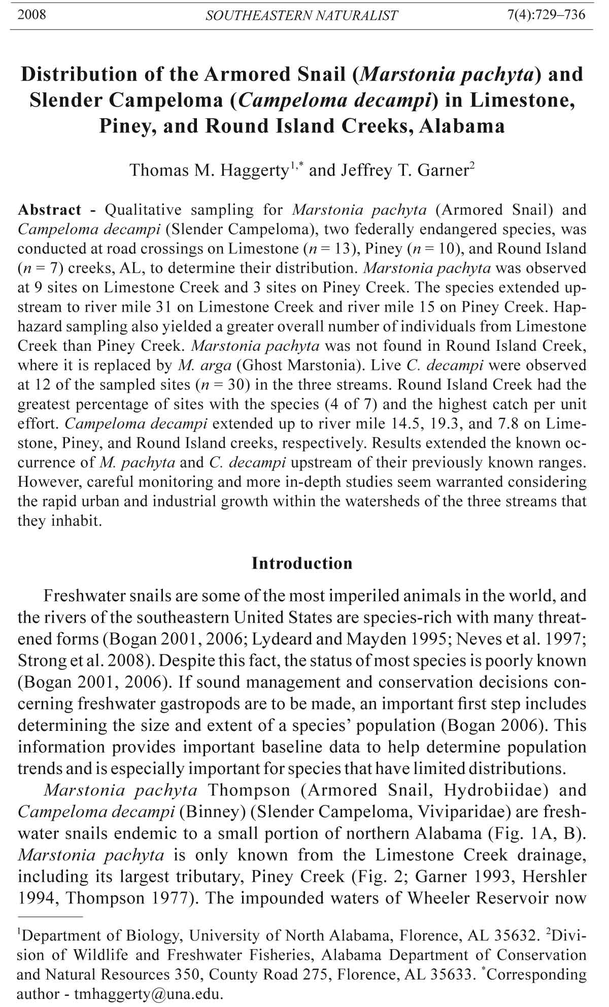
Figure 1. Campeloma decampi (A); Marstonia pachyta showing two apical glands
(arrows) on verge (B); and Marstonia arga showing single apical gland (arrow)
on verge and distinct angle of penis (C). The Campeloma decampi and Marstonia
pachyta specimens pictured are from Limestone Creek, Limestone County, AL, and
the Marstonia arga specimen is from Round Island Creek, Limestone County, AL.
2008 T.M. Haggerty and J.T. Garner 731
is mostly gravel with interstitial silt. The pools and marginal areas often have
deposits of mud, frequently associated with beds of Justicia americana (Linnaeus)
Vahl (Waterwillow). Accumulations of detritus are often encountered
in pools. Exposed bedrock occurs at some sites, but outcrops are generally
not extensive. Terrain surrounding the three streams is primarily agricultural
or forested, but encroachment of residential areas has increased considerably
in the last decade, especially in the Piney Creek drainage. Riparian zones
are generally intact and banks are stable, with breaks in riparian vegetation
localized. Canopy cover in most reaches is extensive, spanning the stream
in many areas. Limestone Creek is approximately 72 km (44.7 mi) long and
has a drainage area of 290 km2 (112 mi2), Piney Creek is approximately 62
km (38.5 mi) long and has a drainage area of 246 km2 (95 mi2), and Round
Island Creek is approximately 25 km (15.5 mi) long and has a drainage area
of 135 km2 (52 mi2).
Limestone and Piney Creeks fl ow into the Limestone Creek embayment,
which enters Wheeler Reservoir at Tennessee River mile (TRM) 311. Round
Island Creek lies west of the Limestone/Piney Creek system and fl ows into
Wheeler Reservoir at TRM 298. Swan Creek and several smaller tributaries
of the Tennessee River lie between Round Island and the Limestone/Piney
Creek systems, but M. pachyta and C. decampi are not known to occur there
(Aquatic Resources Center 1997, Garner 1993). The snail fauna of Swan
Figure 2. Study
area showing survey
sites on Round
Island, Piney, and
Limestone creeks,
Limestone and
Madison counties,
AL. Survey site
identification symbols
correspond to
those used in Table
1.
732 Southeastern Naturalist Vol. 7, No. 4
Table 1. Location information and results of surveys from 30 sites on Limestone, Piney and
Round Island creeks, Limestone and Madison counties, AL, 2006–2007. Individual counts are
from live individuals collected from haphazard sampling by a single observer per hour.
Campeloma Marstonia
Sample Latitude Longitude decampi/ pachyta/
ID Date Creek (°N) (°W) hr/observer hr/observer
LC1 7-Aug-2006 Limestone 34.63159 86.86696 4 30
LC2 14-Aug-2006 Limestone 34.61924 86.86133 1 0
LC3 14-Aug-2006 Limestone 34.67538 86.87849 2 7
LC4 14-Aug-2006 Limestone 34.67159 86.86472 1 24
LC5 14-Aug-2006 Limestone 34.72955 86.84373 1 29
LC6 18-Aug-2006 Limestone 34.77287 86.79949 8 30
LC7 18-Aug-2006 Limestone 34.80289 86.81602 0 36
LC8 18-Aug-2006 Limestone 34.83510 86.80869 0 51
LC9 25-Aug-2006 Limestone 34.85185 86.81519 0 46
LC10 25-Aug-2006 Limestone 34.88425 86.78394 0 33
LC11 1-Sep-2006 Limestone 34.91610 86.74838 0 0
LC12 1-Sep-2006 Limestone 34.91439 86.73061 0 0
LC13 1-Sep-2006 Limestone 34.93302 86.71972 0 0
PC1 14-Aug-2006 Piney 34.73085 86.90857 0 0
PC2 15-Aug-2006 Piney 34.64296 86.89172 0 33
PC3 15-Aug-2006 Piney 34.65752 86.90029 4 0
PC4 15-Aug-2006 Piney 34.70695 86.90777 0 40
PC5 1-Sep-2006 Piney 34.88704 86.89311 0 0
PC6 1-Sep-2006 Piney 34.86156 86.90630 0 0
PC7 17-Jan-2007 Piney 34.76334 86.90956 0 50
PC8 26-Jan-2007 Piney 34.78825 86.88976 4 0
PC9 26-Jan-2007 Piney 34.80291 86.88394 0 0
PC10 27-Mar-2007 Piney 34.82961 86.89474 0 0
RIC1 15-Aug-2006 Round Island 34.73233 87.07191 7 0
RIC2 16-Aug-2006 Round Island 34.71412 87.05223 3 0
RIC3 16-Aug-2006 Round Island 34.75293 87.08434 18 0
RIC4 16-Aug-2006 Round Island 34.78312 87.04561 0 0
RIC5 16-Aug-2006 Round Island 34.78165 87.05461 0 0
RIC6 16-Aug-2006 Round Island 34.77747 87.07181 16 0
RIC7 18-Aug-2006 Round Island 34.78886 87.03632 0 0
Creek appears to have closer affinities to Elk River, which lies west of Round
Island Creek, than to the faunas of Limestone, Piney, and Round Island
creeks, so it was not included in this survey (J.T. Garner, pers. observ.).
Qualitative sampling for M. pachyta and C. decampi was conducted at road
crossings on Limestone Creek (n = 13) in Limestone and Madison counties, on
Piney Creek (n = 10) in Limestone County, and on Round Island Creek (n = 7)
in Limestone County (Fig. 2, Table 1). Presumably, reaches between bridge
crossings hold significant populations. However, low water levels during the
drought of 2006 made fl oat surveys of these streams impractical. Sampling
was carried out between river miles 4.5 and 38 on Limestone Creek, between
river miles 3 and 29 on Piney Creek, and between river miles 0.5 and 10 on
Round Island Creek. Sites were sampled in August (n = 21) and September (n
= 5) of 2006, and in January (n = 3) and March (n = 1) of 2007. Haphazard sampling
on approximately 100-m reaches was carried out by two or three observ2008
T.M. Haggerty and J.T. Garner 733
ers for an average of 61 minutes (range = 25–105, n = 30) per site. Although
our primary focus was to determine the occurrence of the two focal species
at each site, catch per unit effort (i.e., number of individuals encountered per
hour per observer) was also recorded. Tributaries of Limestone, Piney and
Round Island creeks are few and generally located in the headwaters of their
respective drainage. These were not included in this study.
To find M. pachyta, a 1-mm mesh dip net was used to collect samples
from submerged tree roots growing along creek edges and from macrophytes
growing in the creek. Submerged tree roots were sampled by vigorously shaking
them within the dip net. Macrophytes were sampled by placing the dip
net just downstream and dislodging gastropods by hand. Dip-net samples
were then washed and sorted in a white pan. To find C. decampi, samples of
substrate were collected with a dip net, metal scoop, or by hand, placed into a
4-mm sieve and washed. Substrates sampled for C. decampi included gravel,
sand, mud, and detritus.
Campeloma decampi was identified in the field by its large size, ovately
conic shell, and tapered, pointed spire, usually with fine, spiral striations
(Fig. 1A; Burch 1989, Garner 2004). No other species of Campeloma
were encountered during this survey. However, Campeloma decisum (Say)
(Pointed Campeloma) is known to occur in Limestone Creek embayment.
Specimens were photographed and returned to the habitat from which they
were collected. Identification of species within Marstonia involves relaxing
and examining reproductive organs (Fig. 1B, C; Hershler 1994). Because
M. pachyta is federally endangered, routine relaxation of individuals encountered
was not feasible. Fortunately, M. pachyta is easily distinguished from
sympatric M. scalariformis Wolf (Moss Pyrg), because the shell of the latter
has a more tapered spire and a angular body whorl and is usually adorned
with a distinct carina. All Marstonia from Limestone and Piney creeks that
were not identified as M. scalariformis were presumed to be M. pachyta
since no additional Marstonia species were encountered during the most recent
survey (Garner 1993). Most Marstonia were released back into the habitat
from which they were collected, but to verify the presence of M. pachyta
in Limestone and Piney creeks and confirm that our field identifications to
genus were valid, two individuals from each creek were collected under
federal permit number TE 130300-00. The specimens of M. pachyta and
other hydrobiids were relaxed with menthol, fixed with formalin, preserved
in 95% ethanol, examined with a 7-45x dissecting microscope, and identified
using Hershler (1994) and Thompson (1977). Specimens will be deposited at
the North Carolina Museum of Natural Sciences.
Results
Marstonia pachyta was found at 12 of the 23 sites sampled on Limestone
and Piney creeks (Table 1). A greater number of sites on Limestone Creek
had M. pachyta (9 of 13 sites) than on Piney Creek (3 of 10 sites) (Table 1).
In Piney Creek, M. pachyta was not found at any of the five sites above river
734 Southeastern Naturalist Vol. 7, No. 4
mile 15 (PC7; Fig. 2, Table 1). On Limestone Creek, all the sites but one
below river mile 30.7 (LC10; Fig. 2, Table 1) had the species, but none were
found at the three sampling sites upstream of that point. Catch-per-uniteffort
data indicate that M. pachyta was in good numbers if suitable habitat
was present (Table 1). Variation in size of individuals was observed at most
sites where this species was found, including juveniles and adults. Marstonia
pachyta was not encountered in Round Island Creek, where the species is
replaced by M. arga Thompson (Ghost Marstonia) (Fig. 1C).
Live C. decampi were located at 12 of 30 of the sampling sites on Limestone,
Piney, and Round Island creeks (Table 1) and an additional two sites
(PC2 and PC9) had only single fresh-dead individuals. Variation in size of
individuals was observed at most sites where the species was encountered.
Round Island Creek had the greatest percentage of sites with the species
(4 of 7; Table 1) and had the highest individual count (44; Table 1), with
the population extending upstream to river mile 7.8 (RIC6). In Limestone
Creek, C. decampi were collected from all six sites downstream of approximately
river mile 14.5 (i.e., LC6), but none were found at the remaining
seven sites upstream of that point. Piney Creek had the lowest percentage
of sites with live C. decampi (2 of 10) and the most upstream site with the
species was at approximately river mile 19.3 (PC8). Piney Creek also had
the greatest distance between location sites and lowest catch per unit effort
(Table 1).
Discussion
Marstonia pachyta was well dispersed in Piney and Limestone creeks
(Table 1). In Limestone Creek, the species was found at two sites (LC8,
LC10) where Garner (1993) did not find it. Further, it was found at six
Limestone Creek localities (LC1, LC4, LC5, LC6, LC7, and LC9) not visited
by Garner (1993). In Piney Creek, M. pachyta was present at two sites
(PC2 and PC4) where Garner (1993) found them and at one additional site
(PC7). The species was again not located in Piney Creek at the Limestone
County Road 44 site (PC9; Garner 1993) or from seven other sites that were
sampled for the first time (Table 1). In both creeks, individuals appeared to
be most common on submerged root masses and bryophytes along stream
edges, submerged bryophytes growing on rocks in moderate current, and
on Waterwillow plants, especially their exposed roots. These dense, finely
branched mats of vegetation may offer excellent sites for feeding, as well as
refuge from predators.
Marstonia pachyta was not found in Round Island Creek. There the species
was replaced by M. arga, which was collected from similar habitats as
those in which M. pachyta was found in Limestone and Piney creeks. Identifications were confirmed by examination of the verges of adult males, and
the two species were easily distinguished. Marstonia pachyta has two small
glands along the left margin of the apical lobe (Fig. 1B), whereas M. arga
(Fig. 1C) has a single gland on an apical lobe that is somewhat expanded
2008 T.M. Haggerty and J.T. Garner 735
compared to that of M. pachyta (Burch 1989, Hershler 1994, Thompson
1977). Marstonia pachyta has never been reported outside of the Limestone/
Piney Creek drainage and is believed to be endemic to the system. Marstonia
arga is widespread in the southern bend of the Tennessee River and in many
tributaries of that reach (Hershler 1994). Periodic sampling of Limestone
and Piney creeks is needed to monitor for the possible colonization by M.
arga, to the potential detriment of M. pachyta.
Marstonia pachyta was more widely dispersed in Limestone Creek than
in Piney Creek. In Limestone Creek, individuals were found upstream to
river mile 31, but only about half that distance on Piney Creek. Piney Creek
seemed less suitable for the species due to anthropogenic factors, including
those associated with sod farming and residential development. More
research is needed to quantify the density and habitat needs of M. pachyta
in these two streams. More detailed anatomical and genetic comparisons are
required to establish differences that may or may not be present between the
Limestone and Piney Creek populations. Also, a population of Marstonia
in Beaverdam Creek (S. Clark, Chicago Academy of Sciences, Notebaert
Nature Museum, Chicago, IL, pers. comm.) was unknown to the authors at
the time of this survey. This population should be examined, as Beaverdam
Creek is part of the Limestone Creek drainage.
Although C. decampi was found in all three creeks, it was most easily
found in Round Island Creek. Round Island Creek appeared to have more
suitable habitat, such as substrates composed of clay along creek margins,
and relatively large patches of Waterwillow growing in clay and mud (see
Garner 2004). Campeloma decampi was most often found burrowing at shallow
depths in these types of substrates. The density of this species in these
types of habitats needs to be quantified and the substrate in which it prefers
to burrow should be thoroughly studied. Also, anatomical and genetic studies
are required to establish differences among the Limestone, Piney, and
Round Island Creek populations. Such work is in progress (D. Campbell,
University of Alabama, Tuscaloosa, AL, pers. comm.).
In summary, this research indicates that M. pachyta remains present in
Limestone and Piney creeks. Although both creeks offer suitable habitat, it
appears to be more widely dispersed in Limestone Creek. Campeloma decampi
was found in all three creeks, but its habitat seems very patchy. This
may restrict its dispersal and abundance within the streams.
Acknowledgments
Thanks to Jeff Powell, Lucas Gilbert, Arthur Bogan, Paul Johnson, Courtney
Graydon, Paul Kittle, and Priscilla Holland for their help with this study.
The manuscript was greatly improved by comments from David Campbell, Paul
Johnson, and an anonymous reviewer. This research was funded by a cooperative
agreement between the US Department of the Interior, Fish and Wildlife Service,
the Alabama Department of Conservation and Natural Resources, and the University
of North Alabama.
736 Southeastern Naturalist Vol. 7, No. 4
Literature Cited
Aquatic Resources Center. 1997. Survey for selected species of gastropods in the
Tennessee River drainage of northern Alabama. Report prepared for US Fish and
Wildlife Service, Asheville, NC. 65 pp.
Binney, W.G. 1865. Descriptions of new species of North American land and freshwater
shells. American Journal of Conchology 1:49–51.
Bogan, A.E. 2001. Extinction wave in the making. Pp. 138–139, In A. Bräutigam and
M.D. Jenkins (Eds.). The Red Book: The Extinction Crisis Face to Face. International
Union for Conservation of Nature and Natural Resources and CEMEX,
S.A., Mexico City, Mexico. 312 pp.
Bogan, A.E. 2006. Conservation and extinction of the freshwater molluscan fauna of
North America. Pp. 373–383, In C.F. Sturm, T.A. Pearce, and A. Valdes (Eds.).
The Mollusks: A Guide to their Study, Collection, and Preservation. American
Malacological Society, Pittsburgh, PA. Universal Publishers, Boca Raton, FL.
460 pp.
Burch, J.B. 1989. North American Freshwater Snails. Malacological Publications,
Hamburg, MI. 365 pp.
Clench, W.J., and R.D. Turner. 1955. The North American genus Lioplax in the family
Viviparidae. Occasional Papers on Mollusks, 2(19):1–20.
Garner, J.T. 1993. A survey for Pyrgulopsis pachyta (Thompson, 1977) in north Alabama.
Report for US Fish and Wildlife Service, Asheville, NC. 15 pp.
Garner, J.T. 2004. Slender Campeloma, Campeloma decampi, P. 118, In R.E.
Mirarchi, J.T. Garner, M.F. Mettee, and P.E. O’Neil (Eds.). Alabama Wildlife.
Volume 2. Imperiled Aquatic Mollusks and Fishes. The University of Alabama
Press, Tuscaloosa, AL. 255 pp.
Federal Register. 2000. Endangered and threatened wildlife and plants: Endangered
status for the armored snail and slender campeloma. 65:10033–10039.
Hershler, R. 1994. A Review of the North American Freshwater Snail Genus Pyrgulopsis
(Hydrobiidae). Smithsonian Contributions to Zoology No. 554. Smithsonian
Institution Press, Washington, DC. 115 pp.
Lydeard, C., and R.L. Mayden. 1995. A diverse and endangered aquatic ecosystem of
the southeast United States. Conservation Biology 9:800–805.
Neves, R.J., A.E. Bogan, J.D. Williams, S.A. Ahlstedt, and P.W. Hartfield. 1997.
Status of aquatic molluscs in the southeastern United States: A downward spiral
of diversity, Pp. 43–85, In G.W. Benz and D.E. Collins (Eds.). Aquatic Fauna
in Peril: the Southeastern Perspective. Special Publication 1, Southeast Aquatic
Research Institute, Lenz Design and Communications, Decatur, GA. 554 pp.
Osborne, W.E., M.W. Szabo, T.L. Neathery, and C.W. Copeland, Jr. 1988. Geologic
map of Alabama, northeast sheet. Special Map no. 220, Geological Survey of
Alabama, Tuscaloosa, AL.
Sapp, C.D., and J. Emplaincourt. 1975. Physiographic regions of Alabama. Map no.
168, Geological Survey of Alabama, Tuscaloosa, AL.
Strong, E.E., O. Gargominy, W.F. Ponder, and P. Bouchet. 2008. Global diversity of
gastropods (Gastropoda; Mollusca) in freshwater. Hydrobiologia 595:149–166.
Szabo, M.W., W.E. Osborne, and C.W. Copeland, Jr. 1988. Geologic map of Alabama,
northwest sheet. Special Map no. 220, Geological Survey of Alabama,
Tuscaloosa, AL.
Thompson, F.G. 1977. The hydrobiid snail genus Marstonia. Bulletin of the Florida
State Museum. Biological Sciences 21:113–158.


 The Southeastern Naturalist is a peer-reviewed journal that covers all aspects of natural history within the southeastern United States. We welcome research articles, summary review papers, and observational notes.