2008 SOUTHEASTERN NATURALIST 7(1):27–48
Current and Historical Composition and Size Structure of
Upland Forests Across a Soil Gradient in North Mississippi
Sherry B. Surrette1,2, Steven M. Aquilani3, and J. Stephen Brewer4,*
Abstract - Comparisons of current and historical tree species composition and
size structure along natural productivity gradients are useful for inferring effects of
disturbance regimes and productivity on patterns of succession. We tabulated occurrences
and estimated diameters of 3483 General Land Office bearing trees across 19
survey townships along an upland soil texture and organic matter gradient in north
Mississippi. We then contrasted this presettlement composition and structure with that
of 2998 trees in sampling plots within present-day mature (>100 years old) upland
forests contained within the survey townships. Presettlement upland communities appeared
to consist of non-successional communities, in which the most abundant trees
were shade-intolerant, fire-tolerant trees (e.g., Quercus marilandica [blackjack oak])
in both large and small size classes across the entire soil gradient. These fire-prone presettlement
assemblages differed greatly from present-day mature uplands, which were
transitional assemblages of upland and fl oodplain trees, with mesophytic fl oodplain
species (both early and late-successional) dominating the smaller size classes.
Introduction
Comparisons of current and historical tree species composition and size
structure are useful for inferring effects of disturbance regimes on patterns
of succession. The differences between pre-colonial (i.e., pre-Europeansettlement;
hereafter presettlement) and current mature forests in North
America can be dramatic, and many are related, at least in part, to modern
fire suppression and exclusion (Abrams 1992, Beilmann and Brenner 1951,
Gilliam and Platt 1999). Accordingly, the current tree species composition
of early and late-successional forests that have experienced a long history of
fire suppression and exclusion may not be the most desirable reference point
for conservation or restoration activities or for testing theories of succession
(Brewer 2001, Gilliam and Platt 1999).
Despite increasing knowledge of the composition of presettlement communities
in North America, we do not fully understand how succession or
patterns of species replacement differed between modern and presettlement
forests. Most would agree that fire and other disturbances played a major role in
shaping presettlement upland forest communities in North America (Beilmann
and Brenner 1951, Braun 1950, Brewer 2001, Dale and Ware 1999, Skeen et
1USDA Natural Resources Conservation Service, 100 West Capitol Street, Jackson,
MS 39269. 2Current address - Natural Heritage Program, Mississippi Museum of
Natural Science, 2148 Riverside Drive, Jackson, MS 39202. 3Delaware County
Community College, Department of Biology, 901 South Media Line Road, Media,
PA 19063. 4Department of Biology, PO Box 1848, University, MS 38677-1848. *Corresponding
author - jbrewer@olemiss.edu.
28 Southeastern Naturalist Vol.7, No. 1
al. 1993, Van Lear and Waldrop 1989). There is some disagreement, however,
about whether these communities represented early successional stages or firemaintained,
non-successional communities (Chapman 1932, Quarterman and
Keever 1962). The prevalence of disturbance-dependent species in presettlement
landscapes does not imply that plant communities were transitional or
comparable to early or mid-successional communities seen today (Brewer
2001). A size- or age-structured forest at middle stages of succession should
show evidence of potential replacement of early successional species by midor
late-successional species (Horn 1975). To our knowledge, however, there
have been no attempts to reconstruct size structure of presettlement tree communities
and thus interpret potential transitions in species composition.
Historical reconstruction of tree species composition along soil gradients
can provide an indirect test of plant life-history theories that focus on soil productivity
and disturbances as selection pressures. Traditional theories predict
that in the absence of disturbances high, soil productivity should produce latesuccessional
forests of shade-tolerant tree species (Grime 1979, Tilman 1988).
In addition, these theories predict that species adapted for surviving and/or
competing well in unproductive soils (i.e., stress-tolerators of Grime [1979];
belowground competitors of Tilman [1988]) are at a competitive disadvantage
in productive soils. Alternatively, these theories predict that the combination
of high productivity and frequent disturbances favors rapidly growing, early
successional species. Species adapted to nutrient-poor soils grow slowly and
reproduce infrequently and therefore are presumed to be incapable of recovering
quickly from disturbances (Grime 1979, Huston 1979). Traditional views
of disturbance, however, assume that frequent disturbance is more or less
equivalent to frequent density-independent mortality of all species (Huston
1979), as opposed to a selective filter that favors those species adapted for
surviving the disturbance (Williamson and Black 1981). The predictions of
general theories are complicated further by the fact that some species adapted
to nutrient-poor soils are more resistant to disturbance than other species
(Grime 1979) and the possibility that variation in soil conditions can indirectly
infl uence disturbance regimes (Brewer et al. 1998, Kellman 1984,).
In this study, we examined variation in tree species composition and
size structure along an upland soil texture and organic matter gradient in
north-central Mississippi. Our specific objectives were 1) to compare the
composition and size structure of tree species in presettlement uplands with
those of mature upland forests today and to elucidate differences in patterns
of succession, and 2) to examine composition and distributions of xerophytic
and mesophytic tree species along an upland soil gradient in presettlement
north Mississippi.
Study Area
We quantified presettlement and current upland tree species composition
in portions of central Marshall County and central and northeast Lafayette
County, which are located along a southeast to northwest gradient of loess
2008 S.B. Surrette, S.M. Aquilani, and J.S. Brewer 29
in north-central Mississippi (Fig. 1). The region is characterized by rolling
hills in the uplands, typically ranging from 10 to 50 m from ridge to hollow,
with slightly greater topographic relief in northeast Lafayette County than
farther west. The areas we sampled appeared to encompass a clear upland soil
productivity gradient in the middle 1800s, as determined by detailed, quantitative
soil analyses of soil organic matter (between 1 and 2% higher in central
Marshall County than in eastern Lafayette County), along with qualitative
assessments of soil texture (Hilgard 1860). Upland areas (including ridges)
throughout central Marshall County and in scattered localities in central Lafayette
County occurred on deep, loess-based silt-loam organic soils, whereas
upland areas in northeast Lafayette County occurred on loamy sand, sandy
loam, or sandy clay-loam soils with Eocene parent material, relatively little
organic matter, and little or no loess (Harper 1913, Hilgard 1860). The uplands
of central Marshall County and parts of central and western Lafayette County
supported relatively large cotton plantations from the mid-1800s to the early
to mid-1900s; most uplands in northeastern Lafayette County, by contrast,
were primarily settled by poor subsistence farmers during this time, and large
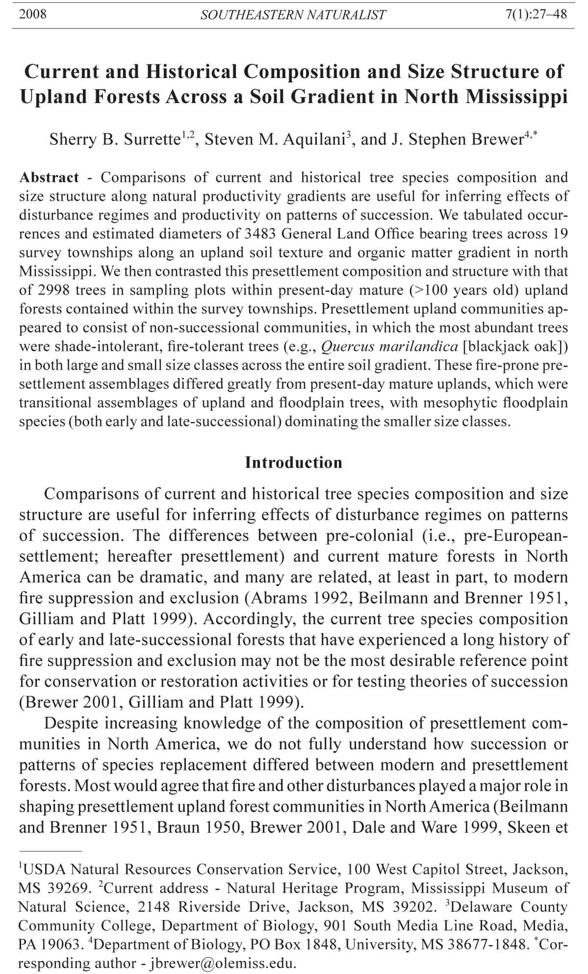
Figure 1. Location of each research site (each containing 1 to 4 plots) in Marshall
and Lafayette counties in northern Mississippi. Shaded squares indicate the location
of townships used to tabulate bearing-tree species composition.
30 Southeastern Naturalist Vol.7, No. 1
plantations were rare (Doyle 2001). Today, this soil gradient is undoubtedly
not as great as it was historically, due in large part to the massive loss of topsoil
following cultivation of the loess-based silt loam soils (Hilgard 1860,
Morris 1981, Tyer et al. 1972). Nevertheless, the presettlement signature of
this soil gradient is still apparent in the current east–west gradient in soil texture,
parent material, and percent organic matter, based on data from county
soil surveys (Morris 1981, Tyer et al. 1972) and direct measurements of soil
texture at the sites (Surrette 2006; Surrette and Brewer, in press).
All research plots were located in upland, closed-canopy forests and were
chosen to meet the following criteria: 1) located on upland soils (i.e., not
fl oodplains or fl oodplain terraces); 2) contained second-growth stands dominated
by mature (100+ years old) trees; 3) burned no more than 3 times since
1978, preceded by a prolonged period (30+ years) of active fire suppression;
and 4) contained a ridge and a lower slope or hollow.
The majority of these sites were located in the Little Tallahatchie Experimental
Forest (LTEF) and the adjacent ranger district of Holly Springs National
Forest (HSNF) in northeastern Lafayette County. Holly Springs National Forest
occupies approximately 62,835 ha (155,270 acres) of Forest Service land,
which is mostly dominated by second-growth stands of hardwoods and pines
(primarily Pinus echinata Miller [shortleaf pine], and to a lesser extent Pinus
taeda L. [loblolly pine]), which grew back after extensive logging in the early
1900s (US Forest Service, Oxford, MS, unpubl. memorandum).
Other sites were located on property managed by the University of Mississippi
in central Lafayette County, and at the Strawberry Plains Audubon
Center (SPAC) in central Marshall County. Three of our research plots were
located on forested land owned by the University of Mississippi since its
charter in 1844 (Brewer 2001, Sansing 1999). Strawberry Plains Audubon
Center is a 1052-ha (2600-acre) wildlife sanctuary that was bequeathed to
the National Audubon Society in 1988 by two private donors. Two of our
plots are located in a mature second-growth oak-hickory-gum forest at
SPAC, which grew back after cotton farming was abandoned on this portion
of the property in the early 20th century (C. Pope, stewardship ecologist at
SPAC, pers. comm.).
Methods
Comparing current and presettlement tree species composition
We established between one and four 75- x 70-m research plots at each site
(giving a total of 13 plots) and quantified current tree species composition within
each research plot by counting stems of each species. All trees ≥1.5 m tall and
10 cm diameter at breast height (dbh; measured at 1.5 m above the ground) were
identified to species and permanently marked at 1.5 m above the ground using
an aluminum tag with a designated identification number secured by an aluminum
nail. Tree species, dbh, and topographical location were then recorded, and
the frequency of current trees by species along ridges and slopes within central
Lafayette, northeastern Lafayette and Marshall counties was then tallied.
2008 S.B. Surrette, S.M. Aquilani, and J.S. Brewer 31
Presettlement tree species composition of upland areas and fl oodplains was
estimated in Marshall and Lafayette counties from tallies of bearing trees obtained
from survey notes from the Marshall and Lafayette county courthouses.
Bearing trees were trees identified by the original land surveyors (in the 1830s
and 1840s) associated with the intersection of section lines and at midpoints
between section lines. All the records we examined showed that the surveyors
marked, identified to common name, estimated the diameter in inches of nearly
all bearing trees, and measured the distance to bearing trees when identifying
sections and quarter-section corners (one section = 2.59 km2 or 1 mile2). In
Marshall and Lafayette counties, two trees were generally identified at quartersection
corners and four trees at section corners.
Although biases associated with bearing-tree selection certainly existed,
original survey records provided the best quantitative sample of trees representative
of old-growth upland forests in the vicinity of our current study sites
before settlement by US citizens (1830–1840s), but during and following sparse
subsistence settlement (primarily near rivers) by Chickasaw livestock ranchers
(Brewer 2001, Johnson 2000). Supporting evidence comes from the qualitative
assessments of the most common trees made by Nutt (1805 in Jennings 1947),
the surveyors themselves, and Hilgard (1860). The earliest quantitative surveys
by scientists were not conducted in this region until the late 1800s and early
1900s, well after much of the region had been cleared for agriculture. By this
time, species composition began to show the signs of the widespread clearing of
forests for agriculture and fire suppression, as exemplified by an increase in the
frequency of Liquidambar styracifl ua L. (sweetgum) in upland areas (Brewer
2001, Dunston 1913, Harper 1913, Lowe 1921). Previous comparisons of bearing-
tree composition with quantitative surveys by experts (e.g., R.M. Harper,
a botanist) before logging and fire suppression have proven that bearing-tree
data can be remarkably reliable indicators of presettlement composition in the
southeastern United States (Schwartz 1994).
We corroborated to the extent possible the accuracy and precision of the
bearing-tree identification in our region by comparing trees identified by surveyors
to those described by Hilgard (1860), whose identification was more
precise (see Brewer 2001). Hilgard consulted with botanists and translated
common names of trees used by locals in the early to mid-1800s to common and
scientific names more widely used at the time (Table 1). A renowned professor
of soil science at the University of Mississippi in the mid-1800s, Hilgard
was commissioned by the state legislature to conduct a statewide soil and vegetation
survey in the 1850s. He was chiefl y interested in identifying the most
abundant species of forests that had not yet been cleared to use as indicators of
soil fertility and fl ooding frequency and therefore the suitability of these sites
for cultivation. He devoted numerous pages to describing the vegetation and
soils of Marshall County and Lafayette County (where he resided). Hence, the
timing of his survey and its relevance to the current study is ideal.
We tallied bearing trees from nineteen townships in Marshall and Lafayette
counties. The location of these townships coincided with the location of each
of our sites. This sampling approach provided an accurate, albeit imprecise,
32 Southeastern Naturalist Vol.7, No. 1
comparison of current and presettlement tree species composition (Wang and
Larsen 2006). In addition, we tallied bearing trees for several townships that
occurred within several major watersheds in Lafayette and Marshall counties.
We did this to ensure an accurate estimate of the distribution of presettlement
mesophytic and fl oodplain tree species, some of which are common in upland
areas today.
Table 1. List of common names as used by surveyors (spelling is as observed in the survey
notes) of trees and their translations to modern common and scientific names (Brewer 2001).
Translation of
modern common
Names used by surveyors names (Hilgard 1860) Scientific names
Ash (including ash and Ash Fraxinus americana L.,
black ash) F. pennsylvanica Marsh.
Beech American beech Fagus grandifolia Ehrhart
Black gum Black gum Nyssa sylvatica Marsh. (possibly
including var. bifl ora (Walter)
Sargent)
Birch River birch Betula nigra L.
Black jack Blackjack oak Quercus marilandica Muenchh.
Black oak Black oak and Quercus velutina Lam., Q. rubra L.
northern red oak
Chestnut American chestnut and Castanea dentata Marsh., Castanea
possibly chinquapin pumila (L.) Miller
Dogwood Flowering dogwood Cornus fl orida L. (possibly other spp.)
Elm (including winged Elm Ulmus alata Michaux, U. americana
elm, American elm, red L., U. rubra. Muhl.
elm, and slippery elm)
Hickory Hickory Carya L. spp.
Holly American holly Ilex opaca Aiton
Ironwood Hop hornbeam, Ostrya virginiana (Miller) K. Koch
ironwood (possibly (possibly Carpinus caroliniana
blue beech, Walter
musclewood)
Maple Maple Acer spp.
Mulberry Red mulberry Morus rubra L.
Persimmon Eastern persimmon Diospyros virginiana L.
Pine Shortleaf pine, bottom Pinus echinata Miller Pinus taeda L.
(loblolly) pine
Poplar Yellow poplar, tulip poplar Liriodendron tulipifera L.
Post oak Post oak Quercus stellata (Wang.)
Red oak (possibly Spanish oak, Quercus falcata Michaux
including cherrybark southern red oak (possibly including Q. pagoda Raf.)
oak)
Sassafras Sassafras Sassafras albidum (Nutall) Nees
Spanish oak Scarlet oak (possibly Quercus coccinea Muenchh.
including shumard oak) (possibly Q. shumardii Buckley)
Sweetgum Sweetgum Liquidambar styracifl ua L.
Sycamore Sycamore Platanus occidentalis L.
Walnut (including black Black walnut, Juglans nigra L., J. cinerea L.
walnut, white walnut, white walnut
butternut)
Water oak Water oak Quercus nigra L.
White oak White oak Quercus alba L.
2008 S.B. Surrette, S.M. Aquilani, and J.S. Brewer 33
We mapped survey points on soil survey maps for Marshall and Lafayette
counties (Morris 1981, Tyer et al. 1972) to determine associations between
presettlement forest composition and landscape position (i.e., occurrence in
uplands vs. fl oodplains). These data were then recorded and pooled according
to all possible combinations of bearing-tree species, survey points, and
landscape position. To determine tree associations with landscape position,
soil types were pooled and grouped into the following categories: lower sandy
slopes of uplands, all other uplands, and fl oodplains and alluvial terraces
(hereafter, fl oodplains). Lower sandy slopes of uplands were distinguished
from other uplands, because the former currently have the greatest plant diversity
of all the types examined (Surrette 2006) and thus are of significant
conservation and management concern.
Comparing current and presettlement size structure of co-occurring trees
We compared diameter variation of bearing trees and current trees in areas
that today occur in Holly Springs National Forest (where shortleaf pine
was and is common) to infer changes in patterns of canopy tree replacement
in presettlement and current oak-pine forests. We used a weighted averaging
approach to test the hypothesis that presettlement upland forests containing
multiple size classes were non-successional communities numerically dominated
by fire-tolerant upland pines and oaks in both the large and the small size
classes. Using the same approach, we also tested the hypothesis that current
upland forests were transitional (i.e., successional) communities, in which
larger trees tended to be upland species and smaller trees tend to be fl oodplain
species. We placed all bearing trees with an estimated diameter of 25 cm or
greater in the large category and all remaining trees in the small category.
Likewise, we placed all current trees with a measured diameter of 25 cm at 1.5
m height in the large category and all current trees 15 to 24.99 cm dbh in the
small category. Using a lower bound of 10 cm did not qualitatively change the
results; only the results using the 15 to 24.00 cm dbh category are presented
here to represent the small category. Sample points were survey points in the
case of bearing trees and sampling plots in the case of the current trees. We
excluded from consideration all survey points that contained trees from only
one diameter category. In the majority of these cases, all trees at the point were
small individuals of Quercus marilandica Muenchh. (blackjack oak), which
even as an older adult tends to be a relatively small tree. Hence, out of a total of
251 survey points with multiple trees in upland soils in northeastern Lafayette
County, 72 points contained trees in both diameter categories. For this reason,
our analysis can only be used to infer compositional differences at points
where multiple size classes existed. It cannot address how common unevensized
stands were in the presettlement landscape.
Associations of upland pines and hardwoods with soil texture, aspect,
and slope position in the presettlement landscape
To determine whether upland areas with organic silt-loam soils supported
a greater fraction of mesophytic species than did regions with sandy
34 Southeastern Naturalist Vol.7, No. 1
or sandy-clay soils with less organic matter, we used a weighted averaging
approach comparable to that used to differentiate upland and fl oodplain species.
Since nearly all fl oodplains in Marshall and Lafayette counties were
known to contain productive soils (Hilgard 1860), if upland soil type had
a significant effect on tree composition, then we might expect a greater
fl oodplain component to tree composition in fertile uplands than in infertile
uplands. To infer which soil and/or topographic characteristics favored pines
in the presettlement landscape in Lafayette County, we examined current soil
types, topography, and bearing-tree records in the following Lafayette County
townships: T7R1, T7R2, T8R2, T8R3, and T9R3. According to Hilgard
(1860), these townships spanned a clear west-to-east gradient in soil texture
and the occurrence of shortleaf pine from central to northeastern Lafayette
County. There was only one record of pine in central Marshall County and so
these townships, which were disjunct from those in Lafayette County, were
excluded from this analysis. Although current soils obviously differed from
presettlement soils due to severe erosion and loss of topsoil following cotton
agriculture in the mid-to late 1800s, in a relative sense, current variation in
soil texture across the region paralleled that of presettlement soils (Hilgard
1860). Exceptions were the severely gullied soil types, which we excluded
from our analysis. To test the hypothesis that pine occurrence in northeastern
Lafayette County depended on soil texture, we tabulated the presence and
absence of pines in different upland soil types using soil survey data as previously
described. Silt loam, soils comprised a “silty” soil category, whereas
sandy, sandy loam and sandy clay-loam soils were grouped into a “not silty”
soil category.
The slope position and aspect at each survey point were determined using
Maptech Terrain Navigator 2004® topographical software. To obtain an objective
estimate of each bearing tree’s position along the slope, the “halfway”
point between the nearest ridge and hollow was used to partition the slope into
upper and lower halves. Any tree located above that point was placed in the
upper slope category; any tree located below that point was placed in the lower
slope category. The aspect of the slope on which each bearing tree occurred
was determined by rotating Terrain Navigator’s 3-dimensional topographic
map to the direction the slope was facing and then recording the compass output.
We grouped all aspects broadly into either north- or south-facing slopes.
We then tabulated the presence and absence of pine and hardwoods at each
slope position and aspect.
Data analysis
Relationships between presettlement tree species composition and landscape
position (i.e., fl oodplains, uplands) were quantified statistically using
indicator-species analysis (DuFrêne and Legendre 1997). Before doing
the analysis, we pooled survey points from central and northeast Lafayette
County. We then calculated indicator values for each species in each landscape
position category by taking the product of each species’ relative abundance
and relative frequency in each landscape position. This product was then
2008 S.B. Surrette, S.M. Aquilani, and J.S. Brewer 35
converted to a percentage by multiplying by 100. The unit of observation for
calculating average relative abundance of each species in each landscape position
category was each landscape-position by survey-point combination. In
most instances, only one landscape position category (e.g., fl oodplain, upland)
occurred at each survey point. However, because more than one tree occurred
at each survey point, in a few cases, particularly those in which survey points
were located at the upland edge of alluvial terraces, two landscape positions
occurred at the same survey point. For this reason, we had more units of observation
than survey points. The relative frequency of each species in each
landscape position was calculated using survey points as the unit of observation.
The statistical significance of the observed maximum indicator value of
each species was calculated using a Monte Carlo test with 1000 permutations.
A P-value < 0.05 was considered statistically significant.
Size structure and composition of current and presettlement upland trees
within the range in which pines occurred were analyzed using a weighted
averaging approach. The weighted averages we used to infer patterns of
replacement in presettlement and current forests were derived from species’
weights produced by an ordination of upland and fl oodplain samples of bearing
trees. Specifically, we used non-metric multidimensional scaling (NMS;
Kruskal 1964) of 6 samples of bearing trees (4 upland and 2 fl oodplain
samples) to obtain scores for each tree species. We sorted upland bearing
trees within the three townships containing the field sites in Holly Springs
National Forest with respect to soil type and topographic position as deduced
from the Lafayette County Soil Survey (Morris 1981). One sample included
all upland trees that were located within 20 m of a small or intermittent creek
or fl oodplain (as determined from aerial photographs). The other three upland
bearing tree samples contained trees that were located farther than 20 m
from a creek or fl oodplain. We classified these three samples with respect to
soil type: sandy-loam soils, silt-loam soils, and sandy-clay-loam soils, and
grouped trees that occurred on silty-clay-loam soils with the sample of trees
on clay-loam soils. We pooled all bearing trees located in fl oodplains associated
with a given watershed into one sample, resulting in two fl oodplain
bearing-tree samples, one for the Tallahatchie River watershed and one for
the Yocona River watershed.
The species scores (i.e., soil type/landscape position weights) derived
from NMS of bearing trees were used to indicate a species’ affinity for upland
or fl oodplain habitat types. We then calculated the average weight for
large and small bearing trees at each survey point and examined differences
between the size classes with a paired-samples t-test. The null hypothesized
difference was zero. To examine differences between bearing and current
trees, we calculated averages of species weights for large and small trees for
the present-day samples of trees. We then compared differences in average
weights of large and small bearing trees in upland areas to an overall average
difference in species scores between size classes in present-day forests
using a paired-samples t-test. Hence, in this analysis, the null hypothesized
36 Southeastern Naturalist Vol.7, No. 1
difference was the overall average difference in species scores between size
classes in present-day forests.
The species scores derived from NMS of bearing trees were also used to calculate
weighted averages of upland tree species composition in each of the three
major areas known to differ in soil texture and possibly productivity (central
Marshall County [silt-loam organic], central Lafayette County [mix of sandy
loam and silt loam], and northeastern Lafayette County [loamy sand and sandyclay
loam, with little organic matter]). Here, we calculated weighted averages
and weighted standard errors of the percentages of all tree species for each region
and examined statistical differences among the three areas using one-way
analysis of variance. If fl oodplain (and thus mesophytic) species represented
a greater fraction of all trees present in upland soils with more silt and organic
matter (e.g., central Marshall County) than in other soils, then the weighted average
percentage should be greater in the organic silt-loam soils.
The NMS of samples of bearing trees was based on Sorensen distances
between samples using arcsine-square-root transformed proportions for each
sample. We used PC-Ord, version 4 for Windows software (McCune and
Mefford 1999) to run NMS, and the “slow and thorough autopilot” routine
in PC-Ord assisted us in making multiple randomized runs to assess dimensionality
and obtain significant ordination axes. We quantified the proportion
of variation in species composition explained by each axis using coefficients
of determination (r2) for the relationships between Sorensen distances and
axis scores.
We used log linear models to determine whether the relative occurrence of
upland pines and hardwoods was independent of soil texture, slope position,
or aspect in Lafayette County. Chi-square tests were performed using Statistix,
version 8, for Windows. To determine whether pine occurrence changed
with soil fertility, we tested the interaction between pine occurrence and
soil-type group (i.e., fertile vs. infertile soil types, the pine presence x soil
fertility interaction). We examined the association between pine occurrence
and slope position by testing the pine presence x slope position interaction.
We examined the association between pine occurrence and aspect (i.e., northvs.
south-facing slopes) by testing the pine presence x aspect interaction. We
then tested the three-way interactions between pine presence, soil fertility, and
slope position and pine presence, slope position, and aspect.
Results
Presettlement versus current tree species composition
We identified a total of 2998 trees in our current, upland tree sampling
plots and tallied a total of 3483 bearing trees across Lafayette and Marshall
counties. We found that current upland forests were composed of a mixture
of historically upland and mesophytic fl oodplain species. Quercus alba L.
(white oak) was the single most common tree species encountered in our
upland study plots (Table 2). Shortleaf pine was the second most common
species (Table 2). Other common species in uplands were Carya tomentosa
2008 S.B. Surrette, S.M. Aquilani, and J.S. Brewer 37
(Poiret) Nutall (mockernut hickory), Carya glabra (Miller) Sweet (pignut
hickory), sweetgum, Quercus stellata Wang. (post oak), Quercus falcata Michaux
(southern red oak), Cornus fl orida L. (fl owering dogwood), and Nyssa
sylvatica Marsh. (blackgum) (Table 2). Blackjack oak, Quercus coccinea
Muenchh. (scarlet oak), and loblolly pine were not common (Table 2).
With some exceptions, current tree species composition was not that different
between upper and lower slopes. Shortleaf pine was the most common
species along upper slopes. Other common species along upper slopes were
post oak, hickory, white oak, and sweetgum (Table 2). All species commonly
found along upper slopes were also common along lower slopes, with the
exception of post oak, which was replaced by southern red oak (Table 2).
In contrast to what we encountered in mature upland forests today,
“black oak,” “blackjack,” “post oak,” and in some areas, “pine” were the
most common bearing trees in upland areas (Table 3). Indicator species
analysis revealed that all were significant indicators of uplands (Fig. 2).
Table 2. Average percent abundance of current trees (≥10 cm diameter at breast height) tallied
within sixteen forest sites across Lafayette and Marshall counties, MS.
Upper slope Lower slope Total
% abundance % abundance % abundance
Species (# stems = 1024) (# stems = 1974) (# of stems = 2998)
Acer rubrum L. 1.17 2.84 2.27
Acer saccharinum L. 0.00 0.05 0.03
Acer sp. 0.58 2.69 1.97
Carpinus caroliniana 0.00 0.05 0.03
Carya sp. 12.31 10.34 11.01
Cornus fl orida 4.98 6.64 6.07
Diospyros virginiana 0.20 0.15 0.17
Fagus grandifolia 0.00 0.86 0.57
Fraxinus sp. 0.33
Juniperus virginiana L. 1.95 2.94 2.60
Liquidambar styracifl ua 7.32 11.65 10.17
Lirodendron tulipifera 0.00 0.25 0.17
Magnolia grandifl ora L. 0.00 0.05 0.03
Morus rubra 0.00 0.15 0.10
Nyssa sylvatica 6.44 4.71 5.30
Pinus echinata 18.16 10.89 13.38
Pinus taeda 6.25 2.58 3.84
Platanus occidentalis 0.00 0.05 0.03
Prunus serotina Ehrhart 1.56 0.96 1.17
Quercus alba 7.42 17.02 13.74
Q. coccinea 1.37 2.08 1.83
Q. falcata 6.09 8.36 7.57
Q. marilandica 1.47 0.96 1.13
Q. nigra 0.10 0.10 0.10
Q. rubra 0.49 0.46 0.47
Q. stellata 13.18 6.03 8.47
Q. velutina 3.81 4.86 4.50
Sassafras albidum 0.20 0.20 0.20
Ulmus alata 4.88 1.57 2.70
Unknown 0.10 0.00 0.03
38 Southeastern Naturalist Vol.7, No. 1
Pines were primarily found in upland areas of northeastern Lafayette County
and were not common as bearing trees in either uplands or fl oodplains or
terraces in southwestern Lafayette or Marshall counties (Table 4). “White
oak,” “hickory,” “sweetgum,” “black gum,” and “beech” (Fagus grandifolia
Ehrhart [American beech]) were common bearing trees in fl oodplains. Accordingly,
indicator species analysis revealed that these species, along with
“sassafras,” “ironwood,” “poplar,” “dogwood,” “ash,” “maple,” “holly,”
and “elm” were significant indicators of fl oodplains (Fig. 2; see Table 1 for
modern translations and scientific nomenclature and authorities). Results
associated with red oak should be viewed with caution, since surveyors used
“red oak” to refer to both southern red oak and Q. pagoda Raf. (cherrybark
oak; Hilgard 1860), which today are considered indicative of uplands and
fl oodplains, respectively.
Table 3. Average percent abundance of presettlement trees associated with fl oodplains and uplands
found in eighteen townships across Lafayette and Marshall counties.
Floodplains (# of stems = 929) Uplands (# of stems = 2554)
Species % abundance % abundance
Ash 2.66 0.04
Bay 0.22 0.00
Beech 7.91 0.04
Birch 0.54 0.04
Black Locust 0.22 0.00
Black oak 7.51 24.16
Blackgum 5.81 0.90
Blackjack oak 1.44 23.25
Cherry 0.47 0.00
Chestnut 0.32 0.47
Chestnut oak 0.11 0.00
Cypress 0.54 0.00
Dogwood 2.27 0.32
Elm 4.20 0.08
Hickory 13.38 8.65
Holly 4.20 0.04
Hornbeam 0.97 0.04
Ironwood 1.11 0.00
Laurel 0.11 0.00
Maple 3.78 0.19
Mulberry 0.00 0.00
Persimmon 0.11 0.00
Pine 0.11 3.92
Poplar 2.60 0.08
Post oak 5.60 23.92
Red oak 8.80 11.23
Sassafras 1.73 0.00
Swamp oak 0.58 0.04
Sweetgum 5.61 0.08
Sycamore 0.22 0.00
Walnut 1.88 0.00
Water oak 0.54 0.00
Willow oak 0.11 0.00
White oak 13.80 2.74
2008 S.B. Surrette, S.M. Aquilani, and J.S. Brewer 39
Shade-intolerant upland species, including “red oak,” “chestnut” (most
likely, Castanea dentata Marsh.), “pine,” and “black oak” were significant
indicators of lower slopes with sandy soils, while “blackjack oak” and
“black oak” were indicative of the remaining portions of the uplands (Fig. 3).
Bearing-tree species indicative of fl oodplains included “American beech,”
“hickory,” “sweetgum,” “elm,” “American holly,” “maple,” “ash, ” “black
gum,” “sassafras,” “ironwood,” “yellow poplar,” and “white oak” (Fig. 3).
When fl oodplain samples were excluded, “white oak” and “chestnut” were
significant indicators of sandy lower slopes, whereas “blackjack oak” was
a significant indicator of the remaining upland areas (Fig. 4). “Black oak”
(which was a significant indicator of uplands when fl oodplain samples were
included) was not a significant indicator of either upland group when the
fl oodplain samples were removed, indicating that it was a common and
abundant bearing tree throughout the upland landscape.
Presettlement versus current size structure of co-occurring trees
The most common large and small bearing trees in upland forests near
Holly Springs National Forest in northeast Lafayette County were upland,
Figure 2. Presettlement tree species that were found to be significant indicators of
uplands or fl oodplains in nine townships across central and northeastern Lafayette
County, MS. Positions along “axis” correspond to calculated indicator values (percent
of perfect indication) for uplands or fl oodplains. Statistical significance was
determined by Monte Carlo permutation tests. † Red oak values should be interpreted
with caution. Surveyors did not distinguish between southern red oak and cherrybark
oak. Red oak is likely a combination of both of these species and perhaps others.
40 Southeastern Naturalist Vol.7, No. 1
Table 4. Percent abundance of presettlement trees associated with well-drained uplands from three
areas within eighteen townships in Lafayette and Marshall counties. NEL = northeastern Lafayette
County (lowest fertility, # of stems = 671), CL = central Lafayette County (intermediate fertility, #
of stems = 392), CM = central Marshall County (highest fertility, # of stems = 1491)
NEL CL CM
Species % abundance % abundance % abundance
Ash 0.15 0.00 0.00
Beech 0.00 0.00 0.07
Birch 0.15 0.00 0.00
Black oak 32.04 13.01 23.54
Blackgum 0.60 0.77 0.54
Blackjack oak 17.44 32.65 23.40
Chestnut 0.89 1.28 0.07
Dogwood 0.15 0.77 0.27
Elm 0.15 0.00 0.07
Hickory 4.92 8.16 10.46
Holly 0.15 0.00 0.00
Hornbeam 0.00 0.26 0.00
Maple 0.15 0.51 0.13
Pine 13.11 2.81 0.07
Poplar 0.15 0.00 0.07
Post oak 19.67 19.39 27.02
Red oak 6.41 18.62 11.46
Swamp oak 0.15 0.00 0.00
Sweetgum 0.00 0.00 0.13
White oak 3.73 1.79 2.55
Willow oak 0.00 0.00 0.13
Figure 3. Presettlement tree species that were found to be significant indicators of
sandy soils found on lower slopes in uplands, all other uplands, and fl oodplains in
nine townships located in central and northeastern Lafayette County, MS. Positions
along “axes” correspond to calculated indicator values (percent of perfect indication)
for each of the three habitat types. Species in large bold type were statistically significant indicators of that habitat. Species not shown were not statistically significant
indicators of any of the three habitat types.
2008 S.B. Surrette, S.M. Aquilani, and J.S. Brewer 41
fire-tolerant, shade-intolerant species. Hence, we found no evidence of transitions
in species composition in upland areas in this region in the early 1800s.
An NMS ordination of the six presettlement samples of trees produced a single
significant axis, which sorted samples according to the relative abundance of
upland indicators such as “blackjack oak,” “black oak,” “pine,” and “post oak”
(negative axis 1 scores) and fl oodplain indicators such as “American beech,”
“American holly,” “sweetgum,” “black gum,” “maple,” “yellow poplar,” and
“white oak” (all with positive axis 1 scores; Table 5). Negative sample scores
were associated with all presettlement upland samples, regardless of soil or
proximity to small creeks. Positive sample scores were associated with fl oodplain
samples. Using these species scores as species weights, we found that
both the large and small size classes of bearing trees at those survey points
containing both size classes of trees exhibited similarly negative average (i.e.,
“upland”) scores (Table 5). The small size class did not contain a significantly
greater fl oodplain component than did the large size class (paired-samples t =
0.75; df = 71; one-tailed P = 0.228).
In contrast to presettlement upland communities, present-day samples of
upland trees in tree plots showed a very significant fl oodplain component in
Figure 4. Presettlement tree species that were significant indicators of uplands and
loamy sandy soils found on lower slopes in nine townships in Lafayette County, MS
after removing fl oodplain samples. Positions along “axes” correspond to calculated
indicator values (percent of perfect indication) for each of the two habitat types.
42 Southeastern Naturalist Vol.7, No. 1
the small size class (two-sample t = 12.83; df = 998; one-tailed P < 0.0001).
The large size class of the present-day samples had a significant upland
component (although still not as great as either the large or small size classes
of presettlement upland tree samples, due in large part to the low abundance
of large blackjack oaks and black oak and the greater abundance of white oak
in the large size class of present-day forests). The average difference between
the composition of the large and small size classes of bearing trees was much
less than compositional differences between size classes in present-day forests
(paired-samples t = 9.23; df = 1; one-tailed P < 0.0001; null hypothesized
difference = 0.39; Table 5).
Associations of upland pines and hardwoods with soil texture, aspect,
and slope position in the presettlement landscape
Fire-tolerant, shade-intolerant oaks were the most common bearing tree
species across a wide range of upland soil types (Table 4; Fig. 5). No one
region appeared to have a more mesophytic tree species composition than
any other, as determined by similar weighted averages of percent abundance
(Fig. 5; F2,39 = 0.132, P = 0.88). The only two species that showed a consistent
positive or negative association with soil texture were “pine” (negative)
and “hickory” (positive). The presettlement distribution of “pine” was associated
with an east–west soil texture gradient in Lafayette County. “Pines”
Table 5. Species composition of large and small trees weighted by their affinity for upland or
fl oodplain samples of bearing trees in the early 1800s in north-central Mississippi. Negative
weights indicate a presettlement association with upland habitats. Positive weights indicate a
greater presettlement association with fl oodplain habitats.
Species Weight (NMS axis 1 species score from analysis of bearing trees)
Eastern red cedar NA
Blackjack oak -0.63
Pine -0.50
Black oak -0.43
Post oak -0.30
Scarlet oak -0.10
Hickory -0.09
Red oak (includes southern red oak and cherrybark oak) 0.25
White oak 0.33
Blackgum 0.60
Dogwood 0.63
Maple 0.74
Ash 1.01
American beech 1.37
Sweetgum 1.38
Yellow poplar 1.41
Elm 1.45
Cherry 1.58
Water oak 1.58
Average weight overstory: presettlement upland -0.323
Average weight midstory: presettlement upland -0.288
Average weight overstory: current upland -0.120
Average weight midstory (15–24 dbh): current upland 0.279
2008 S.B. Surrette, S.M. Aquilani, and J.S. Brewer 43
occurred more often in sandy and sandy clay-loam soils in northeastern
Lafayette County than in silt loam soils in central Lafayette County (“pine
presence” x soil type interaction χ2 = 54.78, df = 1, P < 0.0001). “Pine” occurrence
was independent of both slope position (“pine” presence x slope
position interaction: χ2 = 0.01, df = 1, P = 0.974) and aspect (“pine” presence
x aspect interaction: χ2 = 1.35, df = 1, P = 0.246), or the interaction between
these factors. The position that “pines” occupied along the slope did not
depend on soil type (“pine” presence x slope position x soil type interaction
χ2 = 2.64, df = 2, P = 0.267) or aspect (“pine” presence x slope position by
aspect interaction: χ2 = 1.20, df = 2, P = 0.548).
Discussion
Current versus historical species composition and size structure of trees
in north Mississippi
The prevalence of bearing trees of “xerophytic” oaks across a wide
range of upland soil types of the presettlement upland landscape of northcentral
Mississippi (with co-occurring pines in non-silty soils), combined
with the near absence of bearing trees of several fire-sensitive species such
as “black gum,” “maples,” “ashes,” “walnuts,” and “sweetgum” in uplands
(while abundant in fl oodplains), is consistent with the hypothesis that fires
were either more frequent or were of greater intensity in the uplands than
in the fl oodplains in northern Mississippi. In southern Missouri, Batek et al.
(1999) found that areas of a presettlement landscape with the highest fire
frequencies (as determined by fire-scar analyses; Guyette and Cutter 1997)
were dominated by mosaic of “oak barrens,” consisting primarily of post
oak, blackjack oak, and black oak, and open forests of shortleaf pine and
black oak. These are precisely the same species that dominated the upland
Figure 5. Weighted averages (+ 1 standard error) of percent abundance of all tree
species in presettlement uplands in each of three regions that differed in soil productivity.
Weights are based on upland versus fl oodplain affinity in the region with
lowest upland soil productivity (northeastern Lafayette County; see Table 4).
44 Southeastern Naturalist Vol.7, No. 1
landscape in north Mississippi (although we cannot rule out the possibility
that some pines encountered in our region were loblolly pine). They also
found that a river acted as a fire barrier, which separated a fire-tolerant
community (e.g., shortleaf pine, black oak) located near a Native American
settlement from a more mesophytic community (e.g. northern red oak, black
gum, and maples) located on the opposite side of the river from the settlement.
Soil fertility and topographical conditions were not responsible for
partitioning these community types.
At those points in the presettlement upland landscape at which large
bearing trees co-occurred with small bearing trees, shade-intolerant oaks
and pines were the most abundant species in both size classes. Hence, we
found no evidence of a forest in transition (i.e., replacement by fl oodplain or
mesic forest species) in the early 1800s. This pattern strongly suggests to us
that some combination of canopy openings and fire played an important role
in maintaining tree species composition in the presettlement upland landscape
in north Mississippi. Although canopy openings can increase sapling
densities of oaks and pines (Brewer 2001), most of these do not successfully
recruit into the midstory in fire-suppressed forests, due to competition from
early successional species that grow rapidly following the formation of canopy
gaps (Brose et al. 1999). On the other hand, repeated low-intensity fires
within closed-canopy forests do not favor regeneration of light-demanding
oaks and pines (Arthur et al. 1998, Brose et al. 1999, Franklin et al. 2003,
Hutchinson et al. 2005). Some species regarded as early successional species
today (e.g., sweetgum) can grow relatively rapidly in the shade as root
sprouts and saplings and are able to respond favorably to large canopy gaps,
thereby exhibiting considerable phenotypic plasticity. They were not, however,
common bearing trees in the presettlement upland landscape in north
Mississippi. We suggest that periodic fires acted as a filter that excluded
or suppressed all fl oodplain tree species (early and late-successional) and
maintained relatively open canopies. Indeed, stand densities (as inferred
from point-to-tree distances) appear to have been lower in the presettlement
upland landscape than in present-day mature upland forests in this region
(Brewer 2001). Likewise, the significant occurrence of shade-intolerant Andropogon
L. spp. (“broomsedges”) in the groundcover of these presettlement
communities [Nutt’s 1805 observations in Jennings (1947)] also suggests an
open canopy. Such conditions would have likely favored upland oaks and
pines. If this hypothesis is correct, then ecological restoration of presettlement
disturbance regimes in mature forests may require a combination of
persistent canopy openings and variable fire frequencies to give small saplings
of oaks and pines an advantage over fire-sensitive fl oodplain species
that are shade tolerant as root sprouts and small saplings but also responsive
to canopy openings (Albrecht and McCarthy 2006, Brose et al. 1999).
The relatively high abundance of fire-dependent and light-demanding
species of bearing trees on sandy lower slopes of uplands above small creeks
during the early 1800s (e.g., shortleaf pine, black oak) suggests that these
2008 S.B. Surrette, S.M. Aquilani, and J.S. Brewer 45
areas experienced moderately frequent fires and/or had a more open canopy
than what we see today. Nevertheless, the greater occurrence of bearing trees
of white oak and chestnut and the relatively low occurrence of blackjack oak
bearing trees in these areas also suggest that the canopy was not as open, soil
moisture was higher, and the frequency or intensity of fires in these areas
might not have been as high as in other areas of the upland landscape. Such
conditions might have created a fire/light/moisture regime that favored a
mixture of open-habitat/fire-dependent species and some mesophytic species.
Hence, sandy lower slopes above creeks may have supported some of
the highest plant diversity in the upland landscape.
Presettlement tree species composition along a soil gradient
Slow-growing, shade-intolerant species were the most-abundant bearing
trees in the uplands of north-central Mississippi across a wide range of soil
texture and organic matter. To the extent that this soil gradient was correlated
with soil productivity, our results contradict predictions of general plant lifehistory
theories, at least as they relate to presettlement upland forests in this
region (Grime 1979, Tilman 1988). These theories predict that the combination
of high soil productivity and frequent stand-replacing disturbances favors
rapidly growing, early successional species. We argue that frequent fires were
not stand-replacing disturbances and acted a species-specific filter in the presettlement
landscape, which excluded or suppressed both fast-growing, early
successional species and shade-tolerant, late-successional species across the
entire upland soil productivity gradient. On the other hand, the bearing-tree
species composition we found in presettlement fl oodplain forests appears to
be at least in part consistent with general plant life-history theories, which
predict that high soil fertilities support late-successional forests dominated by
shade-tolerant tree species in the absence of frequent or intense disturbances.
Presettlement fl oodplains and terraces, which contained fertile soils and likely
experienced fires that were either less frequent or less intense than in upland
areas (Beilmann and Brenner 1951), contained large numbers of bearing trees
of shade-tolerant and fire-sensitive species such as American beech (as well as
less shade-tolerant white oak, hickories, and possibly cherrybark oak) in north
Mississippi, and thus appear to have approximated mesic late-successional
forests. However, the significant abundance of early successional species such
as sweetgum in these fl oodplain forests suggests that long-lived, phenotypically
plastic species capable of rapid growth responses to canopy gaps were
also favored in these forests.
Despite the widespread occurrence of fire-tolerant tree species in the
presettlement uplands, there was nonetheless some modest variation in tree
species composition in relation to soil texture. Bearing trees of pines occurred
along ridges and slopes (north- and south-facing) and in hollows in
infertile loamy sands and sandy clay-loam soils, but were for the most part
absent from organic, loess-based silt-loam soils in central Marshall County
and most of central Lafayette County. Also, bearing trees of hickories appeared
to occur more frequently in organic silt-loam soils. Our findings agree
46 Southeastern Naturalist Vol.7, No. 1
with Hilgard (1860), who indicated that the occurrence of both shortleaf pine
and hickories in north central Mississippi followed an east–west gradient in
soil fertility in Lafayette County. The western uplands of Lafayette County
were dominated by black oak, post oak, and blackjack oak (with hickories
being subdominant), whereas the eastern portion of the county consisted of
a mixture of pines and the same species of oaks that were the common bearing
trees in the western portion of the County, but with few bearing trees of
hickories. We do not have a satisfactory explanation for why the xerophytic
oaks occurred throughout the soil gradient, whereas the pines did not. One
possibility is that the oaks are more shade-tolerant than the pines and thus
were favored in the richer soils. Hilgard (1860) noted that individuals of
blackjack oak and post oak growing in fertile soils in Marshall County had
relatively straight trunks and few limbs (possibly due to their growing in
more dense stands in these areas), in stark contrast to the crooked trunks and
numerous lower limbs produced by these species in sandy, nutrient-poor
soils in northeast Lafayette County. Therefore, xerophytic oaks may have
exhibited enough intraspecific variation in growth patterns to adapt to a wide
range of soil fertilities and the associated modest variation in stand density
and light availability. Regardless of what limited the distribution of pines
in uplands, pines and upland oaks were more similar to one another with
respect to environmental requirements than they were to mesophytic hardwoods.
Arguments about natural distributions of pine and hardwoods that do
not distinguish between fire-tolerant upland oaks and mesophytic hardwoods
should be viewed with skepticism.
Acknowledgments
The authors thank the members of S.B. Surrette’s dissertation committee: Marjorie
M. Holland, Lucile McCook, David H. Reed, and Gregory L. Easson. Sarah
Hinman, Esther Mwangi, Heath Capello, Doug Hohman, and Amy Nicholas helped
with fieldwork. We also thank three anonymous reviewers and Andy Ezell for their
constructive comments on the manuscript. This research was funded by the National
Audubon Society and a cooperative agreement (SRS 04-CA-11330127-116) between
the University of Mississippi and the USDA Forest Service, Southern Research Station,
Center for Bottomland Hardwoods Research, Stoneville, MS, with matching
funds from the USDA Forest Service, Southern Region, National Forests in Mississippi,
Jackson, MS (USDA National Forest).
Literature Cited
Abrams, M.D. 1992. Fire and the development of oak forests. BioScience 42:
346–353.
Albrecht, M.A., and B.C. McCarthy. 2006. Effects of prescribed fire and thinning
on tree-recruitment patterns in central hardwood forests. Forest Ecology and
Management 226:88–103.
Arthur, M.A., R.D. Paratley, and B.A. Blankenship. 1998. Single and repeated fires
affect survival and regeneration of woody and herbaceous species in an oak-pine
forest. Journal of the Torrey Botanical Society 125:225–236.
2008 S.B. Surrette, S.M. Aquilani, and J.S. Brewer 47
Batek, M.J., A.J. Rebertus, W.A. Schroeder, T.L. Haithcoat, E. Compas, and R.P.
Guyette. 1999. Reconstruction of early nineteenth-century vegetation and fire
regimes in the Missouri Ozarks. Journal of Biogeography 26:397–412.
Beilmann, A.P., and L.G. Brenner. 1951. The recent intrusion of forests in the
Ozarks. Annals of the Missouri Botanical Garden 38:261–282.
Braun, E.L. 1950. Deciduous Forests of Eastern North America. Blakiston,
Philadelphia, PA. 596 pp.
Brewer, J.S. 2001. Current and presettlement tree species composition of some upland
forests in northern Mississippi. Journal of the Torrey Botanical Society 128:
332–349.
Brewer, J.S., J.M. Levine, and M.D. Bertness. 1998. Interactive effects of elevation
and burial with wrack on plant community structure in some Rhode Island salt
marshes. Journal of Ecology 86:125–136.
Brose, P., D.H. Van Lear, and C. Cooper. 1999. Using shelterwood harvests and prescribed
fire to regenerate oak stands on productive upland sites. Forest Ecology
and Management 113:125–141.
Chapman, H.H. 1932. Is the longleaf type a climax? Ecology 13:328–334.
Dale, E.E., and S. Ware. 1999. Analysis of oak-hickory-pine forests of Hot Springs
National Park in the Ouachita Mountains, Arkansas. Castanea 64:163–174.
Doyle, D.H. 2001. Faulkner’s County: The Historical Roots of Yocknapatawpha. The
University of North Carolina Press, Chapel Hill, NC.
Dufrêne, M., and P. Legendre. 1997. Species assemblages and indicator species:
The need for a fl exible asymmetrical approach. Ecological Monographs 67:
345–366.
Dunston, C.E. 1913. Preliminary examination of the forest conditions of Mississippi.
Mississippi State Geological Survey, Jackson, MS. Bulletin No. 11.
Franklin, S.B., P.A. Robertson, and J.F. Fralish. 2003. Prescribed-burning effects on
upland Quercus forest structure and function. Forest Ecology and Management
184:315–335.
Gilliam, F.S., and W.J. Platt. 1999. Effects of long-term fire exclusion on tree species
composition and stand structure in an old-growth Pinus palustris (longleaf pine)
forest. Plant Ecology 140:15–26.
Grime, J.P. 1979. Plant Strategies and Vegetation Processes. John Wiley and Sons,
London, UK.
Guyette, R.P., and B.E. Cutter. 1997. Fire history, population, and calcium cycling in
the Current River watershed. Proceedings of the Central Hardwood Conference
11:354–372.
Harper, R.M. 1913. A botanical cross-section of northern Mississippi, with notes
on the infl uence of soil on vegetation. Bulletin of the Torrey Botanical Club 40:
377–399.
Hilgard, E.W. 1860. Report on the geology and agriculture of the state of Mississippi.
State Geological Survey. Jackson, MS.
Horn, H.S. 1975. Markovian properties of forest succession. Pp. 196–211, In M.L.
Cody and J.M. Diamond (Eds.). Ecology and Evolution of Communities. Belknap
Press, Cambridge, UK.
Huston, M.A. 1979. A general hypothesis of species diversity. American Naturalist
113:81–101.
Hutchinson, T.F., E.K. Sutherland, and D.A. Yaussy. 2005. Effects of repeated fires
on the structure, composition, and regeneration of mixed-oak forest in Ohio. Forest
Ecology and Management 218:210–228.
Jennings, J.D. 1947. Nutt’s trip to the Chickasaw Country. Journal of Mississippi
History 9:35–61.
48 Southeastern Naturalist Vol.7, No. 1
Johnson, J.K. 2000. The Chickasaws. Pp. 85–121, In B.G. McEwan (Ed.). Indians of
the Greater Southeast. University of Florida Press, Gainesville, FL.
Kellman, M. 1984. Synergistic relationships between fire and low soil fertility in
neotropical savannas: A hypothesis. Biotropica 16:158–160.
Kruskal, J.B. 1964. Multidimensional scaling by optimizing goodness of fit to a
nonmetric hypothesis. Psychometrika 29:1–27.
Lowe, E.N. 1921. Plants of Mississippi: A list of fl owering plants and ferns. Mississippi
State Geological Survey, Jackson, MS. Bulletin No. 17.
Mccune, B., and M.J. Medford. 1999. PC-ORD. Multivariate analysis of ecological
data, version 4. MjM Software Design, Gleneden Beach, OR.
Morris, W.M., Jr. 1981. Soil survey of Lafayette County, Mississippi. USDA Soil
Conservation Service, Oxford, MS.
Quarterman, E., and C. Keever, 1962. Southern mixed hardwood forest: Climax in
the Southeastern coastal plain, USA. Ecological Monographs 32:167–185.
Sansing, D.G. 1999. The University of Mississippi: A sesquicentennial history. University
of Mississippi Press, Jackson, MS.
Schwartz, M.W. 1994. Natural distribution and abundance of forest species and communities
in northern Florida. Ecology 75:687–705.
Skeen, J.N, P.D. Doerr, and D.H. Van Lear. 1993. Oak-hickory-pine forests. Pp.
1–33, In W.H. Martin, S.G. Boyce, and A.C. Echternacht (Eds.). Biodiversity of
the Southeastern United States: Upland Terrestrial Communities. John Wiley and
Sons, New York, NY.
Surrette, S.B. 2006. Environmental conditions promoting plant species diversity
in upland hardwood and hardwood-shortleaf pine forests of the interior Coastal
Plain ecoregion. Ph.D. Dissertation. University of Mississippi, University, MS.
Tilman, D. 1988. Plant Strategies and the Dynamics and Structure of Plant Communities.
Princeton University Press, Princeton, NJ.
Tyer, M.C., W.E. Bright, and P.J. Barlow. 1972. Soil survey of Marshall County, Mississippi.
USDA Soil Conservation Service, Holly Springs, MS.
Van Lear, D.H., and T.A. Waldrop. 1989. History, uses, and effects of fire in the
Appalachians. USDA. Forest Service, Southeastern Forest Experiment Station,
Asheville, NC. General Technical Report SE-54.
Wang, Y.C., and C.P.S. Larsen. 2006. Do coarse resolution US presettlement land
survey records adequately represent the spatial pattern of individual tree species?
Landscape Ecology 21:1003–1017.
Williamson, G.B., and E.M. Black. 1981. High temperature of forest fires under
pines Pinus as a selective advantage over oaks Quercus, ecosystems, Florida
sandhill, plant succession. Nature 293:643–644.


 The Southeastern Naturalist is a peer-reviewed journal that covers all aspects of natural history within the southeastern United States. We welcome research articles, summary review papers, and observational notes.