2011 SOUTHEASTERN NATURALIST 10(2):303–320
Impacts of Oil and Gas Development on Wintering
Grassland Birds at Padre Island National Seashore, Texas
Ardath L. Lawson1,2, Michael L. Morrison1,*, and R. Douglas Slack1
Abstract - Padre Island National Seashore provides important habitat for declining
wintering grassland birds, yet oil and gas development is widespread in the Park. Our
objective was to evaluate the effects of resource extraction on the wintering grassland
birds of the Park. In January–March 2007 and 2008, we surveyed 5 active and 4 abandoned
well sites and 4 road sites to investigate the relationship between distance from
disturbance (well pads, access roads) and bird abundance. At road sites, bird abundance
was positively correlated with increased distance from road edge, but we found no linear
relationship at active or abandoned well sites. However, mean bird abundance in the first
(0–30 m) distance interval of active well transects was less than half that at the second
interval, and was the lowest value for all active intervals except the ninth. First-interval
abundance at active wells was lower than abundance at any abandoned well interval.
Road transects likewise showed low abundance in the initial interval, although unlike at
active wells, abundance increased steadily with distance from the center of disturbance.
This trend of lower overall numbers at the first interval of active well transects was driven
largely by Sturnella magna (Eastern Meadowlark) and S. neglecta (Western Meadowlark).
A combination of high noise levels near active well pads and lack of tall vegetation
from which to sing may have contributed to low numbers of meadowlarks, which were
the only birds to sing regularly during the study period. We recommend: (1) reducing
noise at active sites, (2) limiting vegetation disturbance near pads and roads, (3) maintaining
existing perch sites, and (4) limiting road construction.
Introduction
In the past few decades, populations of grassland birds have declined noticeably
throughout their breeding ranges across the continental US. Brennan and
Kuvlesky (2005) reviewed and evaluated the causes of the widespread declines
of grassland birds in North America. They concluded that the causes for these
declines were many and varied by geographic location, including afforestation
in the eastern United States, fragmentation and outright loss of prairie vegetation,
and large-scale degradation of western rangelands. Although most evidence
implicates habitat changes in the breeding range for this decline, this emphasis
may be due in part to the large extent to which grassland bird research has focused
on breeding season studies. This focus on breeding season ecology occurs
despite the fact that most grassland species are migratory and spend at least half
the year in migration and on separate wintering grounds (Igl and Ballard 1999).
1Department of Wildlife and Fisheries Sciences, Texas A&M University, College Station,
TX 77843-2258. 2Current address - Center for Advanced Study of Museum Science
and Heritage Management, Texas Tech University, Lubbock, TX 79409. *Corresponding
author - mlmorrison@tamu.edu.
304 Southeastern Naturalist Vol. 10, No. 2
As a result, it is still uncertain what role habitat loss or alteration on the wintering
grounds of grassland birds may play in their recent decline.
Southern Texas is known to provide important grassland habitat for wintering
birds and is a frequent stopover site for migratory birds (Igl and Ballard 1999).
However, much of the native prairie along the Texas coast has been converted to
cropland or lost to urban development, so that less than 1% of the original coastal
grassland is now considered to be in relatively pristine condition (Smeins et al.
1991). Birds inhabiting Texas grasslands have shown widespread declines in geographic
range and abundance. In south Texas, for example, Flanders et al. (2006)
found that the conversion of native grasslands to those dominated by exotic grass
species resulted in lower bird abundance, due in part to a substantially lower arthropod
abundance in exotic relative to native grasslands. Igl and Ballard (1999) studied
grassland birds wintering in south Texas. They found that grassland birds occurred
in a wider variety of habitat conditions during winter than previously described. For
example, species most characteristic of herbaceous grassland vegetation on breeding
grounds occurred at least occasionally in habitats with woody vegetation.
A substantial portion of the remaining grassland in southern Texas is located
on Padre Island National Seashore (PAIS). Fifteen of the 18 grassland bird species
shown by the North American Breeding Bird Survey to have experienced
population declines in the past 30 years have been documented at PAIS (Echols
2004), making its preservation a priority of avian conservation. Padre Island has
had an extensive history of oil and gas extraction beginning even before the Park
was founded in 1961. From 1951 to 1981, a total of 70 oil and gas development
operations occurred within the boundary of PAIS, consisting of 58 oil and gas
wells, 6 pipelines, and 6 seismic exploration operations (National Park Service
2005). Well sites and access roads abandoned within the past few decades have
been restored to some degree as a result of regulations placed on oil companies
since the 1970s. The quality of restoration varies noticeably among the old well
sites in the Park, but restoration techniques have evolved and become more rigorous
over the last few decades (D. Echols, National Park Service, Padre Island
National Seashore, TX, pers. comm.). Also, the dynamic environment of the
island contributes to the obliteration of abandoned sites by flooding, dune degradation,
and the movement of sand dunes and vegetation over time. Consequently,
greatest concern in the Park currently revolves around the impacts of ongoing
resource extraction operations at active wells.
Although the number of operations has declined overall, as of September 2006
there were still 8 active wells located within the Park and 8 more in the planning
phases (D. Echols, pers. comm.). All active wells were located in the northern
section of the Park, most likely because no park roads extend to the southern section,
making access to the south end more expensive and difficult. Because of
measures put into place to protect the shoreline and wetlands of the Park, most
drilling has taken place in the interior grasslands of the island, with unknown
impacts on the many bird species that inhabit the area during the fall and winter.
Such impacts could include not only the physical disturbance from well pads and
the effects of accidental discharges that may occur in the course of operations, but
2011 A.L. Lawson, M.L. Morrison, and R.D. Slack 305
also the effects of road construction, traffic, human activity, and noise originating
both along access roads and at well pads themselves.
To remedy this lack of basic knowledge of the problem, our goal was to evaluate
the effects of oil and gas development on the grassland birds of the Park.
Specifically, our objectives were to investigate: (1) how distance from disturbance
affects numbers of birds; (2) how distance from disturbance affects species composition
of birds; (3) whether numbers, species composition, and species richness of
birds differ among active wells, inactive wells, and road sites, and the general vegetation
conditions of each site; and (4) how noise levels change with distance and
whether this is correlated with changes in numbers or species of birds
Study Area
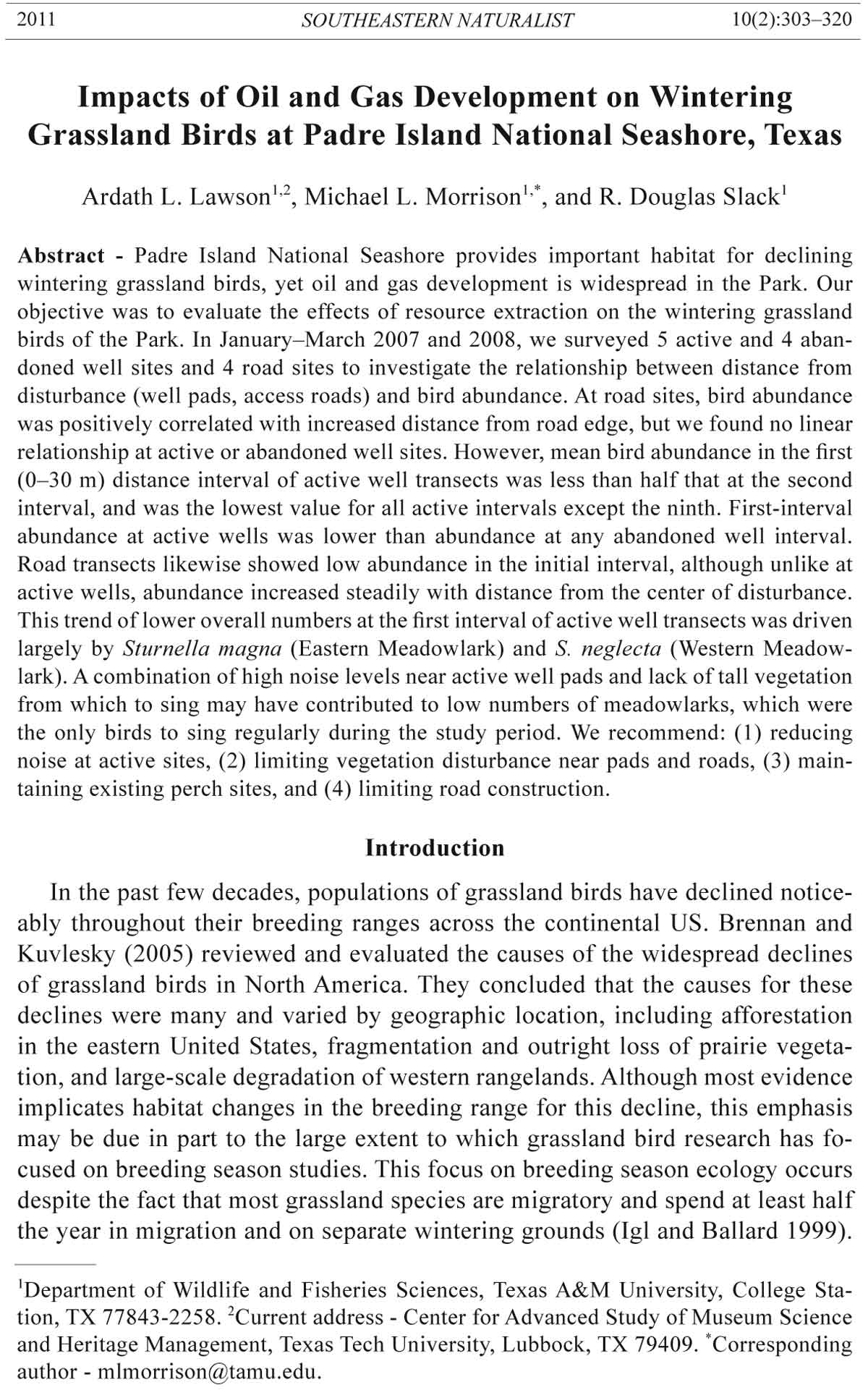
We conducted our research at Padre Island National Seashore, located
along the Texas Gulf Coast (Fig. 1). Padre Island is the southernmost in a
series of 5 barrier islands that form the Texas coast. It is also the longest barrier
island in the US, extending 182 km from Corpus Christi south to Brazos
Figure 1. Map of the southern Texas Gulf coast, with close-up of study areas on the northern
portion of Padre Island National Seashore. Shown are locations of all study sites for 2007–
2008, classified as 3 different site types: active wells, abandoned wells, and access roads.
306 Southeastern Naturalist Vol. 10, No. 2
Santiago Pass. The island is low-lying and narrow, ranging in width from 0.5
to 7.8 km, and is separated from the mainland by the shallow, hypersaline
Laguna Madre. The National Seashore occupies 106 km, or about 60% of the
total length of the island, with the remainder of the island being largely urbanized
and developed for tourism. The northern and southern sections of the
Park are ecologically distinct, the south being drier with more dunes and tidal
flats, and the north containing more wet grasslands and emergent vegetation
(Drawe and Kattner 1978).
In addition to numerous hectares of wetland, Padre Island contains a large
interior grassland component dominated by Schizachyrium scoparium littorale
(Nash) Gould (Little Bluestem), Paspalum monostachyum Vasey (Gulfdune Paspalum),
Spartina spp. (cordgrass), and Adropogon glomeratus Britton, Sterns, &
Poggenb. (Bushy Bluestem). Where backdune areas merge with interior grassland,
Uniola paniculata L. (Sea Oat) is also common and herbaceous species
such as Opuntia spp. (prickly pear) and Physalis cinerascens Hitchc. (Ground
Cherry) become more widespread. Wetter areas contain a mixture of grasses,
sedges, Scirpus spp. (bulrush), and occasionally Typha domingensis Pers. (Cattail).
Wildfires are common across the undeveloped portions of the island (Drawe
and Kattner 1978).
The climate is semi-arid and subtropical, and the island is continuously exposed
to strong, moisture-laden gulf winds (Drawe et al. 1981). Most rainfall occurs
May–October, with a peak in September. Temperatures are warm throughout the
year and rarely drop below freezing, though numerous cold fronts pass through
each winter, and some are strong enough to damage cold-sensitive plants (Carls et
al. 1995). Hurricanes and tropical storms are infrequent but strongly shape island
topography and vegetation when they occur. During our study, weather conditions
varied greatly from one field season to the next. Conditions during the 2007 field
season averaged slightly cooler than in 2008, with an average high temperature of
17.5 °C the first season and 19.4 °C the second. More significantly, the Park also
received an above average amount of rainfall in December 2006 (11.1 cm, compared
to an average of 4.3 cm), just prior to the start of the study. As a result, many
areas in the northern section of the Park that were usually dry or damp grasslands
were partially flooded, and large bodies of standing water remained throughout the
winter of 2007. In contrast, conditions during the 2008 season were much drier as
a result of lower rainfall in 2007. The Park received 33 cm less in rain in 2007 than
2006, and rainfall for December 2007 was only 0.2 cm (PAIS, unpubl. data). Consequently,
several semi-permanent water sources were drastically shrunken from
the year before or even dried up completely.
Methods
Site selection
Our study focused exclusively on the section of PAIS extending from the
northern boundary of the Park to the 15-mile marker at Yarborough Pass, because
2011 A.L. Lawson, M.L. Morrison, and R.D. Slack 307
this is where nearly all oil and gas drilling in the Park has occurred. Because several
wells were sited on tidal mudflats and other ecotypes only marginally used
by grassland birds, we confined our study to only those wells located in areas
dominated by interior grassland and dune vegetation.
We sampled 3 types of sites: active wells, abandoned wells, and roads. Active
wells consisted of those that were either being drilled or that were currently
in use for pumping and storing natural gas during the study season. Wells in the
drilling phase were the most active and were associated with the highest amount
of traffic, noise, and human activity.
We studied all five wells that were active in the Park during the 2-year study
period: Wilson, Sprint, Dunn-Peach 1 and 2, and Lemon-Lemonseed. Sprint and
Dunn-Peach 1 were completed wells in the pumping stage throughout both the
2007 and 2008 seasons of our study, while Wilson was in the drilling phase for
the entire first season and in the pumping stage during the second season. Drilling
activity took place at Dunn-Peach 2 during the first few weeks of the 2007 field
season, but was later shut down. At the start of the second field season in 2008, a
new drill rig was erected at Dunn-Peach 2, and drilling resumed for the remainder
of the season. Abandoned wells in our study were those that had been plugged
and from which all or most of the structures and machinery had been removed.
Because there were >50 abandoned well sites scattered throughout the Park and
not all had been marked with Universal Transverse Mercator (UTM) coordinates,
it was not possible to sample all abandoned wells. Using aerial photographs and
descriptions provided by a previous study (Carls et al. 1987), we determined
which old wells had likely been sited in grassland areas and attempted to find all
such wells for which approximate coordinates were available. However, it proved
impossible to locate all former wells due to incomplete records or obliteration by
natural or human-induced changes in topography and vegetation. Consequently,
we could include only 4 abandoned wells in our study.
To look at road impacts from resource extraction alone, we considered only
those roads constructed by the oil companies for well access, and did not include
roads created by the Park for visitor use or those open only to park personnel.
Only 2 major oil and gas access roads were in operation during the course of our
study. One of these roads connected the Wilson well to a park road at the north
end of the Park, while the other, known as the Pan-Am road, connected 2 well
sites farther down the island and allowed access directly from the beach. These
2 roads were similar in construction, but the newer Wilson well road had been
designed with input from the NPS and was intended to minimize impacts to
the water flow regime of the area. Both were dirt roads surfaced with a layer of
caliche, and both received traffic on a daily basis from trucks and construction
vehicles (no statistics on specific traffic volume were available).
Bird surveys
For each well site, we laid out 4 transects of 300 m each extending perpendicular
in the cardinal directions from the center of disturbance (e.g., well). Similarly,
for each access road site, we laid out two 300-m transects perpendicular to the
308 Southeastern Naturalist Vol. 10, No. 2
sides of the road. We surveyed the Pan-Am road using 3 separate sites randomly
distributed along the grassland portions of the road but no closer to each other
than 500 m. The short length of the Wilson well road allowed the placement of
only one pair of road transects. All transects at wells and roads were marked visually
at both ends and at 10-m intervals using surveyors’ tape and flags.
During 6 surveys of each transect, we assigned each bird observation to a distance
band perpendicular to the transect (0–9, 10–19, 20–29, 30–40, and >40 m).
We visually estimated this as the distance from the center line of the transect to
the spot at which the bird was first sighted. Each 300-m transect was additionally
divided along its length into 10 intervals of 30 m each, representing increasing
distance from the center of disturbance. We recorded numbers and species of
birds for each interval. Except for a few species of raptor that search for prey
aerially, we did not count birds flying overhead without landing, because it could
not be concluded that they were actually using or inhabiting the area covered by
the transect.
We conducted all surveys between sunrise and 12:00 during January–March
of 2007 and 2008. Surveys took place only on clear to overcast days with no fog
or precipitation, with wind speeds ≤29 km/h. During the 2007 field season, the
survey crew consisted of two people walking approximately 15 m apart and dragging
a rope between them to flush skulking birds (distance bands were used for
counting). A third member was added to the survey crew in 2008 to record data
and take noise readings, but the 2 primary observers remained the same for both
field seasons.
Noise measurements
During each bird survey, we used a Martel Electronics 320 sound-level meter
to take noise readings at 0, 150, and 300 m from the well or road. This soundlevel
meter was capable of measuring noise from 30–130 dB in a frequency range
of 31.5 Hz to 8 KHz, which we considered adequate for measuring most noise
associated with oil and gas extraction activities as reported by other studies (e.g.,
Bureau of Land Management 2000). Each noise reading consisted of an average
value taken over a 5-second period, rounded to the nearest decibel.
Vegetation surveys
We conducted vegetation sampling using the same line transects used for bird
surveys, taking measurements at each 10-m interval. We used a point-intercept
method to record hits of each grass species or forb touching each of every 0.25-m
interval on a 2-m high range pole. The vegetation characteristics we measured
were maximum vegetation height, litter depth, percent grass cover, percent forb
cover, and percent bare ground. Percent grass and forb cover were calculated
as the percentage of all points at which grass or forbs touched the pole. For the
purposes of measuring bare ground, we considered all points to be bare where
the base of the range pole did not come in contact with any grass or forb; this did
not necessarily preclude the presence of grass or forb cover above the ground. We
also measured water depth and percent water cover the first year, when several of
our transects were partially flooded.
2011 A.L. Lawson, M.L. Morrison, and R.D. Slack 309
Data analysis
We used 7 grassland passerines as our focal species: Passerculus sandwichensis
(Savannah Sparrow), Ammodramus savannarum (Grasshopper Sparrow),
Ammodramus leconteii (Le Conte’s Sparrow), Cistothorus platensis (Sedge
Wren), Anthus rubescens (American Pipit), Dendroica coronate (Yellow-rumped
Warbler), and meadowlarks; we combined meadowlark species (Sturnella magna
[Eastern Meadowlark] or S. neglecta [Western Meadowlark]) because they
occurred together and exhibited the same general behavior. We selected these
species because they represent the primary grassland passerine species in our
study area. Because of the extremely brief viewing time we had of most sparrows
that we flushed, we could not always assign a species (either Grasshopper or Le
Conte’s Sparrow) to all sparrows of the genus Ammodramus that we observed.
Because these unidentified sparrows constituted about half of all observed Ammodramus,
we assigned these a separate category for data analysis rather than
omitting them entirely.
For all analyses, we used an index of bird abundance calculated by taking the
mean of all bird sightings across each of our 6 transect visits. We assumed detectability
to be virtually the same across all sites because birds along the center
of the transect were equally likely to be flushed by rope dragging regardless of
site type or vegetation differences, while birds beyond the rope could only be
located when perching or flying, which were also easily observed at any location.
Although detectability of birds certainly declined with distance from the center
of the transect, there was no reason to believe that this decrease in detectability
did not affect all sites similarly. Differences in noise levels did not change detectability
of birds because all birds were located visually.
We used univariate linear regression models (Zar 1996:317–352) to test
whether bird abundances and vegetation parameters changed with increasing distance
from well pads or roads. We present all regression results but only provide
graphs for statistically significant relationships; relationships at P > 0.05 are in
Lawson (2009). We used a 95% confidence interval to detect differences in noise
levels (dB) among site types at the beginning, middle, and end of all transects. To
test for differences in avian abundance and vegetation among our three site types,
we ran analyses of variance (ANOVA) using the Tukey test to determine signifi-
cance (Zar 1996:235–276). We also computed means and standard errors for each
vegetation parameter and for noise levels. Because trends in bird abundance and
noise levels did not differ significantly (P < 0.05) across field seasons, we pooled
data from both 2007 and 2008 for our analyses. All statistical analyses were performed
using the SPSS statistical package (Version 16.0; Norusis 1994).
Results
Avian abundance
Total numbers of all grassland birds sighted (Table 1) were comparable
across years (n = 1221 in 2007, n = 1195 in 2008), as were abundances for most
species. Savannah Sparrows made up over half (≥57%) of the birds sighted in
310 Southeastern Naturalist Vol. 10, No. 2
Table 1. Total sightings (n) of all grassland birds with mean abundances (birds/transect/visit) ± standard error (SE) for 3 site types (active wells, abandoned
wells, access roads), Padre Island National Seashore, 2007–2008.
2007 2008
Abundance ± SE Abundance ± SE
Species n Active Abandoned Road n Active Abandoned Road
Turkey Vulture, Cathartes aura L. 7 0.03 ± 0.01 0.04 ± 0.02 0.00 ± 0.00 4 0.01 ± 0.01 0.03 ± 0.02 0.02 ± 0.02
Northern Harrier, Circus cyaneus L. 22 0.17 ± 0.04 0.03 ± 0.02 0.12 ± 0.06 13 0.04 ± 0.02 0.05 ± 0.02 0.06 ± 0.04
White-tailed Hawk, Buteo albicaudatus Vieillot 29 0.24 ± 0.10 0.07 ± 0.02 0.10 ± 0.40 14 0.01 ± 0.01 0.05 ± 0.02 0.10 ± 0.50
Crested Caracara, Polyborus plancus Jacquin 5 0.01 ± 0.01 0.04 ± 0.02 0.00 ± 0.00 4 0.01 ± 0.01 0.02 ± 0.01 0.00 ± 0.00
American Kestrel, Falco sparverius L. 3 0.04 ± 0.02 0.00 ± 0.00 0.00 ± 0.00 0 0.00 ± 0.00 0.00 ± 0.00 0.00 ± 0.00
Merlin, F. columbarius L. 1 0.01 ± 0.01 0.00 ± 0.00 0.00 ± 0.00 2 0.01 ± 0.01 0.01 ± 0.01 0.00 ± 0.00
Peregrine Falcon, F. peregrines Tunstall 2 0.03 ± 0.02 0.00 ± 0.00 0.00 ± 0.00 0 0.00 ± 0.00 0.00 ± 0.00 0.00 ± 0.00
Northern Bobwhite, Colinus virginianus L. 3 0.03 ± 0.02 0.00 ± 0.00 0.00 ± 0.00 2 0.00 ± 0.00 0.00 ± 0.00 0.04 ± 0.04
Wilson's Snipe, Gallinago delicata Ord 8 0.04 ± 0.02 0.05 ± 0.02 0.00 ± 0.00 1 0.00 ± 0.00 0.01 ± 0.01 0.00 ± 0.00
Mourning Dove, Zenaida macroura L. 156 1.90 ± 0.95 0.12 ± 0.05 0.00 ± 0.00 2 0.01 ± 0.01 0.00 ± 0.00 0.00 ± 0.00
Horned Lark, Eremophila alpestris L. 1 0.00 ± 0.00 0.01 ± 0.01 0.00 ± 0.00 0 0.00 ± 0.00 0.00 ± 0.00 0.00 ± 0.00
Sedge Wren, Cistothorus platensis Wilson 13 0.03 ± 0.02 0.12 ± 0.03 0.00 ± 0.00 85 0.29 ± 0.04 0.46 ± 0.05 0.17 ± 0.05
American Robin, Turdus migratorius L. 2 0.03 ± 0.02 0.00 ± 0.00 0.00 ± 0.00 0 0.00 ± 0.00 0.00 ± 0.00 0.00 ± 0.00
American Pipit, Anthus rubescens Tunstall 19 0.06 ± 0.03 0.11 ± 0.04 0.08 ± 0.04 16 0.05 ± 0.02 0.07 ± 0.03 0.06 ± 0.04
Loggerhead Shrike, Lanius ludovicianus L. 0 0.00 ± 0.00 0.00 ± 0.00 0.00 ± 0.00 3 0.01 ± 0.01 0.02 ± 0.01 0.00 ± 0.00
Yellow-rumped Warbler, Dendroica coronate L. 19 0.16 ± 0.08 0.07 ± 0.03 0.00 ± 0.00 0 0.00 ± 0.00 0.00 ± 0.00 0.00 ± 0.00
Vesper Sparrow, Pooecetes gramineus Gmelin 7 0.04 ± 0.03 0.01 ± 0.01 0.02 ± 0.02 1 0.00 ± 0.00 0.00 ± 0.00 0.02 ± 0.02
Savannah Sparrow, Passerculus sandwichensis Gmelin 579 2.59 ± 0.50 3.11 ± 0.34 1.75 ± 0.37 597 2.15 ± 0.23 2.71 ± 0.26 2.00 ± 0.34
Grasshopper Sparrow, Ammodramus savannarum Gmelin 18 0.05 ± 0.02 0.06 ± 0.02 0.17 ± 0.05 53 0.21 ± 0.04 0.16 ± 0.04 0.29 ± 0.07
Le Conte's Sparrow, A. Leconteii Latham 35 0.17 ± 0.04 0.16 ± 0.04 0.14 ± 0.05 34 0.13 ± 0.03 0.11 ± 0.03 0.29 ± 0.07
Unknown Ammodramus spp. 40 0.21 ± 0.05 0.15 ± 0.04 0.21 ± 0.06 30 0.18 ± 0.04 0.05 ± 0.02 0.08 ± 0.04
Swamp Sparrow, Melospiza georgiana Latham 1 0.01 ± 0.01 0.00 ± 0.00 0.00 ± 0.00 0 0.00 ± 0.00 0.00 ± 0.00 0.00 ± 0.00
Unknown sparrow 32 0.12 ± 0.04 0.18 ± 0.04 0.12 ± 0.05 29 0.09 ± 0.03 0.11 ± 0.04 0.19 ± 0.06
Meadowlarks, Sturnella magna L., S. neglecta Audubon 206 1.21 ± 0.22 0.83 ± 0.12 0.76 ± 0.21 244 0.88 ± 0.13 0.99 ± 0.17 0.67 ± 0.17
Great-tailed Grackle, Quiscalus mexicanus Gmelin 0 0.00 ± 0.00 0.00 ± 0.00 0.00 ± 0.00 48 0.41 ± 0.25 0.00 ± 0.00 0.00 ± 0.00
2011 A.L. Lawson, M.L. Morrison, and R.D. Slack 311
either field season (Table 2). Meadowlarks were the next most common taxa,
accounting for 22% of all sightings during either year. Each of the other focal
species accounted for ≤10% of all sightings. Savannah Sparrows were sighted
in proportionately greater numbers at abandoned (64%) than active or road sites
(each 57%). Meadowlarks constituted nearly the same proportion of total sightings
at active (23%) and abandoned well sites and a slightly smaller proportion
(17%) along road transects.
Mean bird abundance did not differ significantly among active (4.4 ± 4.1),
abandoned (4.4 ± 3.5), and road sites (3.6 ± 3.1). We further divided active
wells into 2 subcategories: actively drilling well sites and pumping station sites
where drilling was no longer taking place (Fig. 2). Again, no significant difference
among the site types was detected, but mean abundance was slightly lower
at drilling wells (3.7 ± 3.1) than at either pumping (4.9 ± 4.7) or abandoned
(4.4 ± 3.5) sites, and was comparable to road-site abundance (3.6 ± 3.1). Bird
abundance at each distance interval was also similar among the 3 site types and
did not differ significantly (Lawson 2009). In spite of this overall similarity in
abundance across sites, bird numbers did appear to be slightly lower in the distance
interval closest to active well pads. Mean abundance at the first interval of
active wells transects (1.18 ± 1.82) was less than half that at the second interval
(2.85 ± 2.51), a significant difference using a standard t-test (P = 0.001). This was
also the lowest value for all active intervals except the ninth (1.1 ± 1.66). Firstinterval
abundance at active wells was lower than abundance at any abandoned
well interval. Road transects also showed low abundance in the initial interval
(1.0 ± 1.79), although, unlike at active wells, abundance increased steadily with
distance from the center of disturbance.
When broken down by sightings of individual species, it appeared that the
trend of lower overall numbers at the first interval of active well transects was
driven largely by meadowlarks and Sedge Wrens. Meadowlark abundance at this
Table 2. Target passerine species as proportion of total sightings at active, abandoned, and road
sites, Padre Island National Seashore, 2007–08. Target species are Savannah Sparrow (SAVS),
Grasshopper Sparrow (GRSP), Le Conte’s Sparrow (LCSP), Sedge Wren (SEWR), American Pipit
(AMPI), Yellow-rumped Warbler (YRWA), and meadowlarks (MEAD), plus Ammodramus genus
sparrows (AMMO).
Year / site SAVS GRSP LCSP AMMO YRWA SEWR AMPI MEAD
2007
Active
Drilling 0.63 0.02 0.04 0.04 0.02 0.01 0.01 0.22
Pumping 0.58 0.01 0.04 0.05 0.04 0.01 0.01 0.27
Abandoned 0.68 0.01 0.03 0.03 0.02 0.03 0.01 0.19
Road 0.59 0.06 0.05 0.07 0.00 0.00 0.01 0.22
2008
Active
Drilling 0.57 0.05 0.04 0.03 0.00 0.08 0.01 0.22
Pumping 0.56 0.05 0.03 0.05 0.00 0.08 0.01 0.23
Abandoned 0.60 0.04 0.02 0.01 0.00 0.10 0.01 0.22
Road 0.55 0.08 0.11 0.02 0.00 0.04 0.02 0.17
312 Southeastern Naturalist Vol. 10, No. 2
first interval (mean = 0.31 ± 0.79) was 47% less than abundance at the second
interval (mean = 0.58 ± 1.42) and was lower than at any other active transect
distance interval. Road-transect observations of meadowlarks were uniformly
low across all intervals. The initial interval of active well transects contained no
sightings of Sedge Wrens, whereas abundance for the remaining intervals ranged
from 0.00 ± 0.00 birds per transect per visit at the ninth interval to 0.25 ± 0.73 at
the fifth (see Lawson 2009 for additional details).
Distance from disturbance and avian abundance
The relationship between distance and bird abundance at active wells differed
slightly depending on how it was analyzed (Fig. 3). On a single visit to 1
active well site in 2007, we sighted large numbers of birds (>20) in the 0–30-m
distance band, primarily Savannah Sparrows. After this visit, we never again observed
such high numbers of birds, ≤5 being sighted during any subsequent visit.
Including the >20 sparrows from the first visit, our regression model showed a
significant but weak linear relationship (R² = 0.041, P = 0.010) between distance
and abundance, with abundance highest close to the well pad and declining with
distance. Excluding this large flock from the analysis, no linear relationship appeared
(R² = 0.00, P = 0.883).
Linear regression models showed no clear linear relationship (R² = 0.004,
P = 0.204) between distance from the well pad and bird abundance at abandoned
Figure 2. 95% confidence intervals for mean bird abundance, Padre Island National
Seashore, 2007–08, at (1.1) active drilling (n = 3), (1.2) active pumping (n = 3), (2) abandoned
(n = 5), and (3) road (n = 4) sites.
2011 A.L. Lawson, M.L. Morrison, and R.D. Slack 313
sites (see Lawson 2009:Fig. 3). Bird abundance showed, however, a significant
increase (R² = 0.625, P = 0.006) with increasing distance from roads (Fig. 4).
Noise monitoring
At all sites, background noise from the ocean was generally in the range of
32–53 dB, depending on distance from the ocean and wind direction and speed.
Noise levels at the starting point of our transects ranged from values in the 30 dB
range at abandoned sites distant from the ocean to a maximum of >80 dB at active
Figure 3. Bird abundance (mean birds/transect interval/visit) with increasing distance
from edge of active well pads, Padre Island National Seashore, 2007–08. Each distance
interval corresponds to 30 m. Diagram A (R² = 0.041, P = 0.010) includes flock
of ≥20 sparrows only sighted once, during Visit 1. Diagram B (R² = 0.00, P = 0.883)
excludes this flock.
314 Southeastern Naturalist Vol. 10, No. 2
sites undergoing drilling. Noise levels at the 0-, 150-, and 300-m intervals were
significantly higher (P = 0.000) at active wells than at either abandoned wells or
roads (Fig. 5). However, noise levels at the end of active transects declined to an
average of 48 dB as compared to approximately 46 dB at the end of both abandoned
and well transects.
When active wells were broken down into pumping wells and actively drilling
sites, the active site types were both significantly different at the 0-m interval
from each other and from abandoned and road sites (Fig. 6). At both 150 and
300 m, drilling wells were still significantly louder than all other site types, none
of which differed significantly from one another.
Vegetation characteristics
Over both study years, neither litter depth nor maximum vegetation height
exhibited any linear trend with distance from the center of disturbance at active,
inactive, or road sites (see Lawson 2009:Figs. 9–14). However, maximum vegetation
height at the first measuring interval was on average 30% lower than at
the next interval.
In 2007, the average maximum vegetation height (Table 3) for each of the 3 site
types ranged between 0.49 m and 0.52 m and did not differ significantly among
types (P = 0.200). Litter depth was also similar among site types (P = 0.170),
with average litter depth among the 3 types differing by ≤1 cm. In 2008, however,
maximum vegetation height (Table 3) differed significantly among the 3 site types,
with vegetation at abandoned sites being on average 14% taller than at active sites
and 11% taller than at road sites. Active sites had the lowest maximum vegetation
Figure 4. Bird abundance (mean birds/transect interval/visit) with increasing distance
from edge of access roads, Padre Island National Seashore, 2007–08. Each distance interval
corresponds to 30 m. R² = 0.625, P = 0.006.
2011 A.L. Lawson, M.L. Morrison, and R.D. Slack 315
height (mean = 0.53 m), and abandoned sites had the highest (mean = 0.64 m). Vegetation
height at active sites was significantly different from that at abandoned sites
(P = 0.000), as was also the case for abandoned and road sites (P = 0.003). Active
Table 3. Maximum vegetation height (m) and litter depth (cm) for active, abandoned, and road
transects, Padre Island National Seashore, 2007–2008.
Active Abandoned Road
Year/ variable Mean ± SD 95% CI Mean ± SD 95% CI Mean ± SD 95% CI
2007
Max veg height (m) 0.49 ± 0.24 0.47–0.51 0.52 ± 0.24 0.50–0.54 0.49 ± 0.20 0.47–0.52
Litter depth (cm) 4.0 ± 7.4 3.3–4.6 4.8 ± 7.6 4.2–5.5 4.2 ± 7.0 3.4–5.1
2008
Max veg height (m) 0.53 ± 0.12 0.48–0.57 0.64 ± 0.07 0.61–0.66 0.56 ± 0.08 0.53–0.60
Litter depth (cm) 7.1 ± 2.1 6.3–7.8 11.5 ± 2.8 10.5–12.5 4.6 ± 2.1 3.9–5.4
Figure 5. 95% confidence intervals for mean noise at 0, 150, and 300 m from the edge
of each site type. active (n = 5),abandoned (n = 5), and road (n = 4) sites, Padre Island
National Seashore, 2007–08.
316 Southeastern Naturalist Vol. 10, No. 2
and road sites were not significantly different (P = 0.101). Litter depth (Table 3)
similarly differed among all site types in 2008 (P = 0.000 for all pairwise comparisons).
Abandoned sites had the highest litter depths of all site types, followed by
active sites and roads. Thus, litter at abandoned sites was 39% deeper than at active
sites and 60% deeper than at road sites.
Percent litter cover differed significantly between 2007 and 2008 at active and
abandoned well sites (P = 0.000 for both), as did percent bare ground (P = 0.023
for active sites and P = 0.001 for abandoned sites). At both types of well sites,
litter cover was nearly twice as great in 2008 as in 2007 (Table 4). In 2007, none
of the 5 cover variables differed significantly (based on over-lapping confidence
intervals) among site types (Table 4). In 2008, percent litter cover and percent
bare ground at road sites were significantly different from both well site types,
with road sites having 24% less litter cover than active sites and 35% less than
Figure 6. 95% confidence intervals for mean noise at 0, 150, and 300 m from the edge of
each of 4 site types, Padre Island National Seashore, 2007–08: active drilling well pad
(n = 3), active pumping well pad (n = 3), abandoned well site (n = 5), and road site (n
= 4).
2011 A.L. Lawson, M.L. Morrison, and R.D. Slack 317
abandoned sites (Table 4). Percent grass cover and percent forb cover showed no
significant differences among any of the 3 site types.
Discussion
While other studies suggest that birds are often negatively affected by
noise and human activity on their breeding grounds (e.g., Veen 1973, Reijnan
et al. 1996), we found little difference in avian abundance among three site
types in wintering habitat. In fact, active wells had slightly higher numbers
of birds than abandoned wells, and passerine diversity was highest along access
road transects. Birds seemed to occupy sites with little regard to overall
noise and activity levels, suggesting that other features of the landscape were
more important factors. Many birds that we observed close to active well sites
were perched on stakes, posts, and other artificial structures associated with
the wells, while a small Prosopis L. (Mesquite Tree) growing within 90 m of
the Dunn-Peach 2 well often contained Savannah Sparrows, Yellow-rumped
Warblers, and Zenaida macroura (Mourning Dove). In these cases, perch sites,
which were otherwise rare features across the island, appeared to be an attraction
that surpassed any possible disturbance from the wells in their vicinity.
Birds may also have frequented active well sites simply because characteristics
of the vegetation were more favorable there than at abandoned wells and road
sites. Vegetation height was significantly taller and litter significantly deeper at
abandoned sites than at active and road sites, which may have reduced the utility
of the abandoned sites to some bird species. Many grassland sparrows, including
Grasshopper and Savannah, cannot forage effectively in places where vegetation
and litter are too dense and instead tend to occupy more open grasslands (e.g.,
Whitmore 1981, Wiens 1969). This apparent preference for areas with lower litter
depths and less dense vegetation may help to account for the lack of effect
that proximity to an active well pad had on most species in our study. Maximum
vegetation height was noticeably lower at the 0-m interval of active sites than at
Table 4. Percent cover values for active, abandoned, and road transects, Padre Island National
Seashore, 2007 and 2008.
Active Abandoned Road
Year/ cover type Mean ± SD 95% CI Mean ± SD 95% CI Mean ± SD 95% CI
2007
Grass 0.88 ± 0.09 0.82–0.94 0.90 ± 0.13 0.83–0.96 0.92 ± 0.09 0.84–0.99
Forb 0.19 ± 0.17 0.08–0.30 0.19 ± 0.13 0.13–0.26 0.15 ± 0.10 0.07–0.23
Litter 0.42 ± 0.21 0.29–0.55 0.47 ± 0.31 0.32–0.62 0.44 ± 0.35 0.14–0.73
Water 0.12 ± 0.17 0.01–0.23 0.05 ± 0.09 0.00–0.09 0.09 ± 0.17 -0.06 –0.23
Bare ground 0.46 ± 0.27 0.29–0.63 0.48 ± 0.35 0.32–0.65 0.48 ± 0.39 0.15–0.80
2008
Grass 0.83 ± 0.13 0.77–0.89 0.93 ± 0.11 0.87–0.99 0.95 ± 0.11 0.85–0.93
Forb 0.15 ± 0.15 0.08–0.22 0.10 ± 0.08 0.05–0.14 0.09 ± 0.11 0.00–0.18
Litter 0.74 ± 0.18 0.65–0.83 0.86 ± 0.14 0.78–0.93 0.51 ± 0.26 0.29–0.73
Bare ground 0.26 ± 0.19 0.17–0.36 0.14 ± 0.14 0.07–0.22 0.49 ± 0.26 0.27–0.71
318 Southeastern Naturalist Vol. 10, No. 2
all other points along the transect at which measurements were taken, being on
average 30% lower than at the next interval. This reduced vegetation may have
been attractive to bird species typically inhabiting more open areas, especially
given that noise and activity did not appear to be correlated with any patterns of
either increased or decreased abundance for most birds.
Sedge Wrens and meadowlarks, however, were sighted in lower numbers at
the first (0–30 m) interval of active well sites than at any other distance interval
along active transects. One outstanding difference between meadowlarks and
the other species in our study is that the meadowlarks were the only birds that
frequently sang throughout both study seasons.
Nearly all singing birds that we sighted were perched on either tall vegetation
or on an elevated prominence such as an old grass-covered dune. The lack of tall
vegetation immediately next to active well pads could have discouraged meadowlark
presence. A previous study on Lanius ludovicianus (Loggerhead Shrike) on
nearby Matagorda Island (Chavez-Ramirez et al. 1994) indicated the importance
of nonwoody vegetation as perches. It seems likely that lack of grassy vegetation
of a sufficient height could contribute to lower numbers of certain species that
commonly use such vegetation as perch sites. Similarly, artificial features such as
stakes and poles associated with well sites might have been less suitable perches
for such species. The high noise levels (up to 84 dB) at active well pads may have
also deterred meadowlarks from occupying the interval closest to the pad. Anything
that interferes with the ability of birds to hear and differentiate among songs
and calls may have a significantly detrimental effect on behavior and survival (e.g.,
Catchpole and Slater 2008, Knight 1974, Kroodsma 2004).
Along road transects, bird abundance clearly increased with distance from the
road. It is unclear why such a trend should have existed near roads and not near
active wells, where noise and activity levels were much higher and occurred far
more constantly than along roads. This trend occurred independently of variations
in either grass height or litter depth, neither of which showed any clear distancerelated
patterns. Although this pattern seems unusual in light of the results from
active well pads, previous research has shown that this is not an unusual trend
in itself. Numerous studies (e.g., Reijnan and Foppen 1994, Reijnan et al. 1987)
have indicated that numbers of breeding birds may be depressed within moderate
distances (≤500 m) of busy highways. It seems possible that the intermittent
nature of the disturbance along the Pan-Am road (i.e., heavy but sporadic road
traffic) was enough to disturb nearby birds but was not constant enough to allow
them to habituate to the noise or activity. Birds at Padre Island may be accustomed
to a relatively high level of background noise (≤56 dB) due to the ocean
and wind, but be more disturbed by loud noises that only occur sporadically. In
addition to the sporadic activity of the roads, taller and thicker vegetation immediately
adjacent to the road edge may have been less suitable to ground-foraging
birds than more open areas farther from roads.
The number of oil and gas operations in the Park is expected to increase in
the next few years (D. Echols, pers. comm.). The impacts from the creation of
new wells are further compounded by the construction of new access roads and
2011 A.L. Lawson, M.L. Morrison, and R.D. Slack 319
the extension of existing ones. Unless wells are sited close to the dune line, their
installation will inevitably involve the construction of miles of access road, with
their potential to disrupt water flows, alter plant growth, and depress bird abundance.
Further research on road impacts in the Park is thus warranted. Based on
our findings, we recommend: (1) continued efforts to reduce noise at active well
sites (e.g., installation of mufflers on compression equipment); (2) ensuring that
disturbance to grasses and other plants does not extend beyond well pads and
road edges; (3) preservation of perch sites; and (4) limiting construction of new
roads wherever possible.
Acknowledgments
We thank D. Echols for assisting with logistics and planning our study at Padre Island
National Seashore, and the National Park Service for providing funding. We also thank
the referees and editors for substantially improving our manuscript.
Literature Cited
Brennan, L.A., and W.P. Kuvlesky, Jr. 2005. North American grassland birds: An unfolding
conservation crisis? Journal of Wildlife Management 69:1–13.
Bureau of Land Management. 2000. Draft RMPA/EIS for federal fluid minerals leasing and
development in Sierra and Otero counties. New Mexico state office, Santa Fe, NM.
Carls, E.G., D.B. Fenn, and S.A. Chaffey. 1987. Cumulative impacts of oil and gas
operations on the soil and vegetation resources of Padre Island National Seashore.
National Park Service Cooperative Park Studies Unit and Texas A&M University,
College Station, TX.
Carls, E.G., D.B. Fenn, and S.A. Chaffey. 1995. Soil contamination by oil and gas drilling
and production operations in Padre Island National Seashore, Texas, USA. Journal
of Environmental Management 45:273–286.
Catchpole, C.K., and P.J.B. Slater. 2008. Bird Song: Biological Themes and Variations.
Second edition. Cambridge University Press, Cambridge, MA.
Chavez-Ramirez, F., D.E. Gawlik, F.G. Prieto, and R.D. Slack. 1994. Effect of habitat
structure on patch use by Loggerhead Shrikes wintering in a natural grassland. Condor
96:228–231.
Drawe, D.L., and K.R. Kattner. 1978. Effect of burning and mowing on vegetation of
Padre Island. Southwestern Naturalist 23:273–278.
Drawe, D.L, K.R. Kattner, W.H. McFarland, and D.D. Neher. 1981. Vegetation and
soil properties of five habitat types on North Padre Island. Texas Journal of Science
33:145–157.
Echols, D. 2004. Assessment of impacts from oil and gas activities on grassland birds
at Padre Island National Seashore. Project Management Information System (PMIS)
No. 72344. National Park Service, Padre Island National Seashore, TX.
Flanders, A.A., W.P. Kuvlesky, Jr., D.C. Ruthven III, R.E. Zaiglin, R.L. Bingham, T.E.
Fulbright, F. Hernaindez, and L.A. Brennan. 2006. Effects of invasive exotic grasses
on south Texas rangeland breeding birds. Auk 123:171–182.
Igl, L.D., and B.M. Ballard. 1999. Habitat associations of migrating and overwintering
grassland birds in southern Texas. Condor 101:771–782.
Knight, T.A. 1974. A review of hearing and song in birds with comments on the signifi-
cance of song in display. Emu 74:5–8.
320 Southeastern Naturalist Vol. 10, No. 2
Kroodsma, D. 2004. The diversity and plasticity of birdsong. Pp. 108–130, In P. Marler
and H. Slabbekoorn (Eds.). Nature’s Music: The Science of Birdsong. Academic
Press, San Diego, CA.
Lawson, A.L. 2009. Impacts of oil and gas development on wintering grassland birds at
Padre Island National Seashore, Texas. M.Sc. Thesis. Texas A&M University, College
Station, TX.
National Park Service 2005. Adminstrative history of Padre Island. Available online at
http://www.cr.nps.gov/history/online_books/pais/adhi8.htm. Accessed 2007.
Norusis, M.J. 1994. SPSS advanced statistics 6.1. SPSS, Chicago, IL.
Reijnan, M.J.S.M., J.B.M. Thissen, and G.J. Bekker. 1987. Effects of road traffic on
woodland breeding bird populations. Acta Ecologia/Ecologia Generalis 8:312–313.
Reijnan, R., and R. Foppen. 1994. The effects of car traffic on breeding bird populations
in woodland I. Evidence of reduced habitat quality for Willow Warblers (Phylloacopus
trochilus) breeding close to a highway. Journal of Applied Ecology 31:85–95.
Reijnan, R., R. Foppen, and H. Meeuwsen. 1996. The effects of car traffic on the density
of breeding birds in Dutch agricultural grasslands. Biological Conservation
75:255–260.
Smeins, F.E., D.D. Diamond, and C.W. Hanselka. 1991. Coastal prairie. Pp. 269–290, In
R.B. Coupland (Ed.). Ecosystems of the World 8A: Natural Grasslands: Introduction
and Western Hemisphere. Elsevier, New York, NY.
Veen, J. 1973. De verstoring van weidevogelpopulaties. Stedebouw en Volkshuisvesting
53:16–26, cited in Synthesis of noise effects on wildlife populations (P. Kaseloo).
Publication No. FHWA-HEP-06-016. US Department of Transportation, Washington,
DC.
Wiens, J.A. 1969. An approach to the study of ecological relationships among grassland
birds. Ornithological Monographs 8.
Whitmore, J.C. 1981. Water base drilling mud landspreading and use as a site reclamation
and revegetation medium. American Petroleum Institute. Forsgren-Perking Engineering,
P.A., Rexburg, ID.
Zar, J.H. 1996. Biostatistical Analysis. Prentice-Hall, Inc., Upper Saddle River, NJ.


 The Southeastern Naturalist is a peer-reviewed journal that covers all aspects of natural history within the southeastern United States. We welcome research articles, summary review papers, and observational notes.