Northeastern Naturalist Vol. 23, No. 2
A.T. McGowan and A.S. Hogue
2016
259
2016 NORTHEASTERN NATURALIST 23(2):259–276
Bat Occurrence and Habitat Preference on the Delmarva
Peninsula
Andrew T. McGowan1 and Aaron S. Hogue1,*
Abstract - White-nose syndrome (WNS) and wind-turbine facilities on the Delmarva
Peninsula are emerging threats to the peninsula’s current bat fauna. However, until our
study, there had been no assessment of bat populations or their habitats in that region.
The purpose of our research was to fill this gap by using 28 road-based transects and
24 passive-monitoring sites to acoustically monitor bats across the peninsula. In total,
we recorded 4432 bat-call sequences and documented the presence of at least 6 species:
Lasiurus borealis (Eastern Red Bat), Eptesicus fuscus (Big Brown Bat), Nycticeius humeralis
(Evening Bat), L. cinereus (Hoary Bat), Perimyotis subflavus (Tri-colored Bat),
1 or more species in the genus Myotis, and potentially Lasionycteris noctivagans (Silverhaired
Bat). Given the similarity in call structure between Silver-haired and Big Brown
Bats, we cannot say with certainty the former were present. Eastern Red Bats, Evening
Bats, and Hoary Bats were relatively widespread and abundant; Tri-colored Bat and
Myotis were not. Of the species for which adequate sample sizes were available, all but
the Hoary Bat (and possibly the Silver-haired Bat) showed strong preferences for forest
edges, demonstrating the importance of these landscape features for maintaining healthy
bat populations. Point-counts along road transects and stationary-monitoring sites yielded
similar results, suggesting that road-based transects are a valuable tool for surveying bat
populations across large geographic areas.
Introduction
Bats are important yet often underappreciated animals. Across the globe, they
play valuable roles in regulating insect populations, pollinating plants, and dispersing
seeds (Galindo-González et al. 2000, Kalka et al. 2008). The critical nature of
their interaction with many ecosystems has led some to propose their use as bioindicator
taxa (Jones et al. 2009). In the mid-Atlantic region of the US, all bats are
obligate insectivores (Voigt et al. 2011, Webster et al. 1985). Although the ecological
significance of these animals extends beyond their diet, bats’ consumption of
aerial insects exerts a powerful control on insect populations, which has ripple effects
throughout ecosystems, such as reducing plant damage from insect herbivory
(Kalka et al. 2008). Bats consume a variety of agricultural pests and can do so in
large numbers (Carter et al. 2004, Whitaker 1995), saving the US agricultural industry
an estimated average of $22.9 billion per year (Boyles et al. 2011). Thus, it
is important to monitor and protect these animals in regions that have large amounts
of native habitat and/or agricultural landscapes that rely on the ecosystem services
provided by bats. One such area is the Delmarva Peninsula.
1Department of Biological Sciences, Salisbury University, Salisbury, MD 21801. *Corresponding
author - ashogue@salisbury.edu.
Manuscript Editor: Jacques Veilleux
Northeastern Naturalist
260
A.T. McGowan and A.S. Hogue
2016 Vol. 23, No. 2
Little is known about bats on Delmarva, which, as a peninsula, may a have
different community structure compared to surrounding areas. Of the handful of
studies conducted here, all were significantly restricted in geographic and ecological
scope (Fox 2007, Johnson and Gates 2008, Limpert et al. 2007, Sjollema et al.
2014, Wolcott and Vulinec 2012). The lack of data at present is particularly disconcerting
due to the recent emergence of 2 significant threats to bats on the peninsula:
White-nose syndrome (WNS) and wind turbines. WNS has killed an estimated 5.5
million bats in the eastern US (Reeder et al. 2012), and has recently spread onto
the northern portion of the peninsula (DNREC 2014). According to various models,
wind turbines in the nearby Appalachian Mountains are projected to kill 33,000
to 111,000 bats annually by 2020, particularly during fall migration (Kunz et al.
2007). In recent years, there have been several proposals for wind-turbine facilities
both on the peninsula and off its shores; however, few studies aimed at assessing
the potential impact of these proposed threats to peninsular bat populations have
been conducted. A baseline assessment of the local bat fauna was needed to help
clarify the current situation and as a basis of comparison with future studies. Given
that habitat use and availability significantly affect the abundance and distribution
of bats, it was also necessary to identify which elements of the landscape are most
often utilized. The purpose of our study was to fill these gaps by determining which
species are present on the peninsula during the summer months, as well as their
habitat preferences at the local and landscape level.
Field-Site Description
The Delmarva Peninsula lies between the Atlantic Ocean to the east and the
nation’s largest estuary, the Chesapeake Bay, to the west (Fig. 1). The peninsula
covers about 15,500 km2 and is located entirely within the Coastal Plain Physiographic
Province (Denver et al. 2004). Findings of studies conducted in the
Choptank watershed suggest that prior to European colonization, roughly 92–94%
of the peninsula was covered in forests, principally mixed hardwood–Pinus (pine)
forests (Benitez and Fisher 2004, Smith and Barbour 1986). Much of the remainder
consisted of marshes and Native American settlements in small clearings (Benitez
and Fisher 2004). Today, the landscape consists of a mosaic of agriculture (48%),
forests (37%), marshes, and various human-modified areas (Denver et al. 2004).
The forests and marshlands are extremely important because of the many ecological
services they offer, including providing valuable habitat to local and migrating
wildlife (Hogue and Hayes 2015, McCann et al. 1993).
Methods
Sampling Sites
We used ArcGIS 10.2 (ESRI 2014) and satellite imagery provided by Maryland
iMap and Delaware Geospatial Data Exchange to lay out transects. We created 28
non-overlapping 18-km transects on the peninsula. We first established 23 idealized
(perfectly straight) east–west transects spaced 10 km apart north to south. Where
Northeastern Naturalist Vol. 23, No. 2
A.T. McGowan and A.S. Hogue
2016
261
the peninsula was wide enough to prevent overlap, we organized the transects into
3 non-overlapping columns: a western column, which started on the western shore
of the peninsula and terminated inland; an eastern column, which started along the
eastern edge of the peninsula and terminated inland; and a middle column, which
was centrally positioned. In some areas, the peninsula could only accommodate
2 non-overlapping eastern and western columns or just a single centrally located
column. We selected this approach to transect design because it ensured that the full
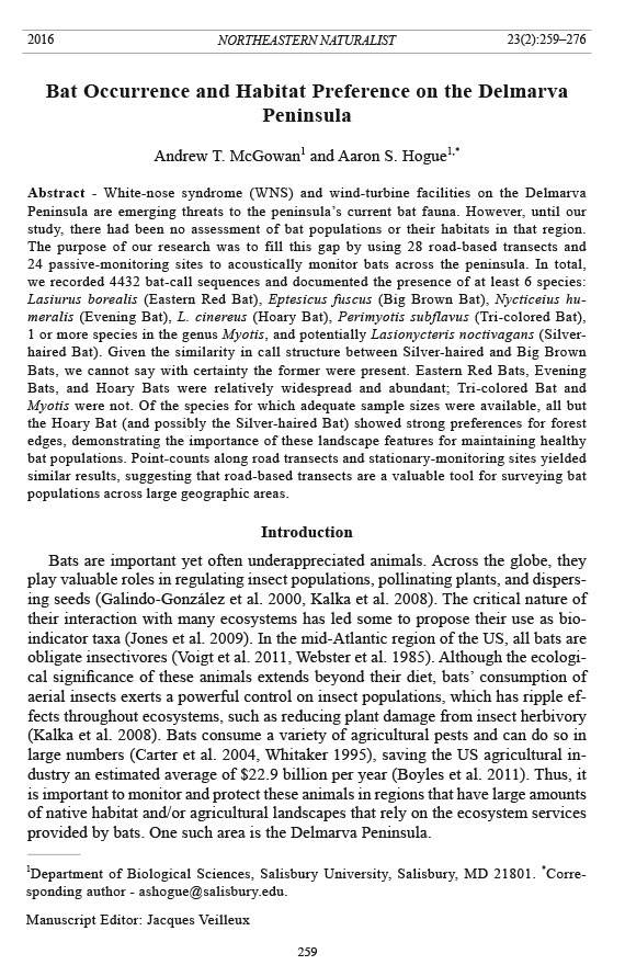
Figure 1. Map of
the Delmarva Peninsula.
Forests are
shown in grey, and
wetlands are indicated
by areas with
diagonal lines. Black
dots represent transect
sampling sites
and black triangles
indicate passivemonitoring
sites.
DE = Delaware, MD
= Maryland, NJ =
New Jersey, and VA
= Virginia.
Northeastern Naturalist
262
A.T. McGowan and A.S. Hogue
2016 Vol. 23, No. 2
range of habitats from the Chesapeake Bay to the Atlantic Ocean was represented in
a systematic and unbiased manner. When space and resources permitted additional
transects, we created an additional 5 north–south transects to fill gaps that were
present between columns, bringing the total number of transects to 28 (Fig. 1).
We planned to access sample points via automobile; thus, we used ArcGIS 10.2
(ESRI 2014) to trace modified transects along 2-lane roads located as close as possible
to the idealized transects. We placed 10 sampling points (sites) 2 km apart (in
linear distance, not driving distance) on each modified transect for a total of 280
sites (Fig. 1). We chose to space the sites 2 km apart to minimize the potential for
recording the same bats at multiple sites, and to avoid overlap in the surrounding
habitat during analyses of habitat use. We sampled at the nearest safe roadside location
to each point.
In addition to active monitoring along transects, we also conducted passive monitoring
overnight at 24 sites (Fig. 1). We selected sites by generating 24 randomly
placed points across the Maryland portion of the peninsula using ArcGIS 10.2
(ESRI 2014). If the point fell on public land, we attempted to obtain permission to
access these points through the agency responsible for the property. If access was
granted, we set up a detector as close as possible to the coordinates of that point
for our sampling site. When the point did not fall on public land, we worked with
local land trusts (Eastern Shore Land Conservancy, Easton, MD; Lower Shore Land
Trust, Berlin, MD), land conservation organizations (The Nature Conservancy,
Snow Hill, MD), and natural resource agencies (Maryland Department of Natural
Resources, Annapolis, MD; US Fish and Wildlife Service, Cambridge, MD) to gain
access to the nearest such property with similar surrounding habitat. We restricted
sampling to the Maryland portion of the peninsula because the land trusts and land
conservation organizations listed above had agreed to facilitate access to a large
number of private properties.
Sampling
We used RStudio (2014) to randomly select driving direction and transects for
sampling without replacement on a single night between June and August 2014
using. Bat-activity levels are typically bimodal in distribution—the largest peak in
activity usually occurs within the first several hours after sunset and there is often
a smaller peak just before sunrise (Hayes 1997). In order to document the abundance
and diversity of bats recorded, we began sampling 30 min after sunset and
terminated once all 10 sites on that transect were sampled ~3 hours later. In order
to limit variation in bat activity between sampling nights, and because bat activity
is significantly affected by precipitation, temperature, and wind, we restricted
sampling to nights with no rain, temperatures above 10 °C, and wind speeds less than 20
km/h (5.6 m/s; Johnson and Gates 2008, Johnson et al. 2008, Jung et al. 1999). We
assessed weather variables at the start of sampling using the National Weather Service’s
forecast for the town closest to the starting location.
To record bats, we employed a miniMIC ultrasonic microphone (Binary Acoustic
Technology, Tucson, AZ) connected by a USB cable to a Dell Venue tablet running
Northeastern Naturalist Vol. 23, No. 2
A.T. McGowan and A.S. Hogue
2016
263
SPECT’R Software (Binary Acoustic Technology). We set the miniMIC to a trigger
threshold of 20 kHz to minimize false triggers by insect noise, with a maximumtime
length of 3 sec to keep the full-spectrum file recordings small enough to easily
be processed by the call-analysis software. We set a threshold amplitude of 18 db
in order to prevent distant noises from triggering the detector. Upon arrival at each
sampling site, we extended the miniMIC 4 m into the air along a telescoping pole
and recorded for 12 min. The 12-min sampling period represented a compromise
between needing to cover a large geographic area in the 3 h of peak bat-activity, and
adequately capturing bat activity at each site. At the end of each period, we turned
the detector off, collapsed the telescoping pole, and drove to the next sampling
point to repeat the process until all 10 sites had been sampled.
For passive survey sites, we monitored bats with a D500X bat detector (Pettersson
Elektronik AB, Uppsala, Sweden) set to record from sunset to sunrise the
following morning. If the property being sampled was an agricultural field or other
open, dry-land site, we placed the detector in a weather-proof box and extended an
external microphone (Pettersson Elektronik) at the tip of a 4-m telescoping pole
held in place by strapping it to a metal stake in the ground. If the sample site was
a marsh, we followed the same procedure but secured the weather-proof box containing
the detector to a floating platform that was tethered to a metal stake. If the
property being sampled was a forest or forest edge, we placed the detector in a tree
strap (Bat Conservation and Management, Carlisle, PA) and attached it to the nearest
tree trunk at a height of 4 m and angled 45° away from the trunk to minimize
interference from the trunk. We set the detector to auto record, a sampling frequency
of 500 kHz, recording length of 3 s, low trigger-sensitivity, no pre-trigger, enabled
HP filter, input gain of 80, trigger level of 120, and an interval of 0. As with the transects,
we restricted sampling to nights with no rain, temperatures above 10 °C, and
wind speeds less than 20 km/h (Johnson and Gates 2008, Johnson et al. 2008, Jung et al.
1999). We assessed weather variables when we deployed the stationary detector, using
the National Weather Service’s forecast for the town closest to the location.
Call analysis and species identification
We attempted to identify each recorded bat pass to species with SonoBat 3.2
automated classifier (Arcada, CA; Szewczak 2015). As recommended by SonoBat,
we set a probability threshold of 90% for accurate species identification. We defined
a bat pass (henceforth referred to as a call sequence) as a series of 1 or more
echolocation pulses with less than 1 s between sequential pulses (Fenton 1970). We visually
inspected call sequences with a questionable species allocation to verify proper
species identification by comparison to the call library and call-identification sheet
provided by sonobat. We tallied the total number of call sequences per species at
each point and imported these data into RStudio (2014) for statistical analyses.
The absolute number of bats at each site cannot be measured accurately from the
call sequences recorded by acoustic detectors (Kunz et al. 2007); thus, we used the
number of bat-call sequences as an overall measure of bat activity, and compared
activity levels between habitats (Vaughan et al. 1997).
Northeastern Naturalist
264
A.T. McGowan and A.S. Hogue
2016 Vol. 23, No. 2
Predicted habitat associations
Local level. We tested habitat associations separately at the local and landscape
levels. We defined the local level as habitat variables within 30 m of the sampling
point, which is the approximate range of detection for the ultrasonic microphone.
Thus, we assumed that any recorded call sequences originated in the immediate
presence of these habitat variables.
We used data from previous ecological research on bats, as well as theoretical
work on wing morphology to predict which elements of the landscape would influence
activity for each species at the local level. Wing morphology is thought to
influence habitat use by bats because differences in wing form affect flight speed
and maneuverability, and therefore which habitat best suits each species for navigation
and foraging (Aldridge and Rautenbach 1987, Fenton 1990, Norberg and
Rayner 1987). Specifically, species with low wing-loadings typically forage in
cluttered forested environments, while species with high wing-loadings utilize open
environments (Norberg and Rayner 1987). At least 7 bat species have been documented
on Delmarva: Lasiurus borealis Müller (Eastern Red Bat), Eptesicus fuscus
(Palisot de Beauvois) (Big Brown Bat), Lasionycteris noctivagans (Le Conte)
(Silver-haired Bat), Nycticeius humeralis (Rafinesque) (Evening Bat), Perimyotis
subflavus (Cuvier) (Tri-colored Bat), Lasiurus cinereus (Palisot de Beauvois)
(Hoary Bat), Myotis lucifugus (Le Conte) (Little Brown Bat), and potentially
other Myotis species (collections of the Smithsonian Institution National Museum
of Natural History, Washington, DC, and Delaware Museum of Natural History,
Wilmington, DE; Fox 2007, Johnson and Gates 2008, Johnson et al. 2011, Limpert
et al. 2007, Paradiso 1969). Of these species, only the Hoary Bat is considered to
be an open-habitat forager (Jantzen and Fenton 2013). The remaining species have
wings more suited to foraging in closed-forest or forest-edge habitats (Farney and
Fleharty 1969, Jantzen and Fenton 2013, Norberg and Rayner 1987). Additionally,
edges provide protection from predators and shelter from wind, which reduces
the energetic costs of flight in windy conditions, and may be important to bats for
navigation (Verboom and Huitema 1997, Verboom and Spoelstra 1999). Edges also
have higher insect abundance than open fields (Gruebler et al. 2008). Based on these
factors and previous studies which have shown especially high activity along forest
edges (Frey-Ehrenbold et al. 2013, Jantzen and Fenton 2013, Morris et al. 2010,
Walsh and Harris 1996, Wolcott and Vulinec 2012), we predicted that every species
except the Hoary Bat would exhibit significantly more activity along forest edges
than in open environments. Our transect sites were at roadsides; thus, all forested
sites were at edges. In instances where forest was on both sides of the road, 2 forest
edges were present. We predicted that sites with 2 forest edges would have higheractivity
levels than those with forest on only one side, and both of these would
have higher activity than sites with only open habitat for all species except for the
Hoary Bat. We define open habitat as marsh (non-forested wetlands), agriculture,
open water (rivers, ponds, bays, etc.), and developed land (defined as any area with
buildings, cut grass, pavement, or similar landscape features maintained for human
use). We classified developed areas as open habitat because they consisted largely
of open spaces with sparsely scattered vertical structures.
Northeastern Naturalist Vol. 23, No. 2
A.T. McGowan and A.S. Hogue
2016
265
Forests in this study usually fell into 1 of 2 types: native mixed hardwood–pine
forests and pine plantations. Pine plantations have a lower diversity of tree species
than mixed hardwood–pine forests, and this feature may negatively impact
diversity and abundance of other plants and insects. If insect populations are reduced
in pine forests, these habitats should have lower bat-abundance than mixed
hardwood–pine forests. However, previous studies have found that many of the bat
species native to Delmarva utilize both logged and unmanaged pine forests (Jung
et al. 1999, Morris et al. 2010) and roost in both forest types (Limpert et al. 2007,
Menzel et al. 2001). To test whether forest-adapted bats prefer mixed forests over
pines, we conducted a secondary analysis to compare bat-habitat use and activity
levels between mixed hardwood–pine and pine-forest sites.
Previous studies have also found that natural water bodies and riparian areas are
important to foraging bats (Lookingbill et al. 2010, Menzel et al. 2005). At the local
level, none of the transects or passive sites fell into these categories. Therefore, we
were not able to assess bat use of these habitats.
To assess whether bats showed habitat preferences beyond those predicted
above, we compared habitat use between all possible habitat combinations (from
each side of the road). Specifically, we compared activity between sites in the following
10 categories: forest only, marsh only, agriculture (ag) only, developed
only, forest–marsh, forest–ag, forest–developed, marsh–ag, marsh–developed, and
ag–developed.
Landscape level. We defined the landscape level as habitat characteristics in the
1-km radius around the site for area and distance measures. We chose a 1-km radius
because a previous study on the peninsula used this scale to investigate which elements
of the landscape are important for bat-roost selection (Limpert et al. 2007).
We used ArcGIS 10.2 to measure all landscape-level habitat variables from satellite
imagery. For distance measures, we quantified the distance from the sampling
point to the edge of the nearest forest, mixed hardwood–pine forest, pine forest,
natural tree-lined water body, and water feature. We defined natural tree-lined water
bodies as streams, creeks, rivers, bays, and ponds with at least some natural, treelined
riparian areas (3 or more trees along edge). Water features included all of the
above types of natural water bodies as well as human-created ones such as drainage
ponds, provided they held water April through September. For area measures,
we drew a 1-km-radius circle around each sampling point using the buffer tool and
calculated the total area of forest and agriculture, and the total length of all forest
edge within each circle.
All species except the Hoary Bat are thought to be forest- and edge-adapted
species (Farney and Fleharty 1969, Jantzen and Fenton 2013, Norberg and Rayner
1987); thus, we predicted that activity would increase for each species, except the
Hoary Bat, as distance to the nearest forest, mixed hardwood–pine forest, and pine
forest decreased.
Based on the established relationships between bats and natural freshwater
bodies, especially riparian areas (Lookingbill et al. 2010, Menzel et al. 2005), we
predicted an increase in activity for all species as the distance to the nearest natural
Northeastern Naturalist
266
A.T. McGowan and A.S. Hogue
2016 Vol. 23, No. 2
water-feature decreased. We tested the prediction that bat activity would be greater
closer to both natural and human-made water bodies because drainage ponds and
other anthropogenic water bodies may also be used by bats.
Forest and forest edge in the surrounding landscape not only provide foraging
area for forest-adapted bats, but also potential roosting sites because many of these
animals use trees as day roosts (Limpert et al. 2007, Menzel et al. 2001). Thus, we
predicted a positive correlation between total bat activity at a site and total percent
of forest and amount of forest edge within a 1-km radius for all species except the
Hoary Bat.
To assess the impact of agriculture on bats, we looked at the correlation between
bat activity and percent area of agriculture in the surrounding 1-km radius. We
predicted a significant positive correlation between Hoary Bat activity levels and
percent area of agriculture because this species is thought to be an open-habitat
forager. For all other bat species, we predicted a negative correlation.
Passive monitoring sites. One major drawback of our roadside-sampling approach
was that we did not sample forest-interior habitats. The addition of passive
sampling allowed us to monitor forest-interior habitats to determine if our roadbased
method missed any species and to compare bat activity along forest edges to
interior-forest conditions. Given previous research suggesting that forest-adapted
bats native to the Delmarva Peninsula prefer forest edges to interior-forest conditions
(Frey-Ehrenbold et al. 2013, Jantzen and Fenton 2013, Morris et al. 2010,
Walsh and Harris 1996, Wolcott and Vulinec 2012), we predicted we would find
higher levels of bat activity at forest edges compared to forest interiors.
Statistical analyses
We employed RStudio (2014), which runs R statistical software, to perform all
analyses (R Core Team 2014). On the local level, we tested habitat predictions by
comparing differences in total bat activity (median number of bat-call sequences
per site) between habitat categories. A Shapiro-Wilk test (Gross and Ligges
2012, Meyer et al. 2014) revealed that the data were not normally distributed;
thus, we used a non-parametric Kruskal Wallis test followed by a 1-tailed Mann-
Whitney U test (α = 0.05) to test predictions that species would exhibit greater
activity in some habitats than others. We restricted our analyses to species that
had a sufficient number of call sequences recorded: Eastern Red Bat, Big Brown
Bat, Evening Bat, and Hoary Bat. Sonobat also identified a large number of call
sequences as belonging to Silver-haired Bat. This species had previously been
found on the peninsula only during periods thought to coincide with spring and
fall migrations (Johnson et al. 2011, Sturgis 2013). Given the surprising nature of
our finding (discussed further in the Discussion section), and the similarity of this
species’ call structure with the more common Big Brown Bat, we analyzed both
sets of calls separately and combined. For predictions in which we compared 3 or
more groups of sites (e.g., forest on both sides of road vs. forest on only one side
vs. no forest), we used a multiple-comparison Kruskal Wallis test with a Bonferroni
correction (Giraudoux 2014).
Northeastern Naturalist Vol. 23, No. 2
A.T. McGowan and A.S. Hogue
2016
267
At the landscape level, we tested predicted correlations between total bat activity
at each site to distance and area measurements using a Kendall’s correlation test for
the species that returned a sufficient number of passes.
Results
Species detected
In total, we recorded 3690 call sequences at transect sites during 56 h (28 nights)
of recording. Of these calls, we identified 65.5% to 1 of at least 7 species: 669 as
Big Brown Bat, 621 as Eastern Red Bat, 528 as Silver-haired Bat, 503 as Evening
Bat, 74 as Hoary Bat, 25 as Tri-colored Bat, and 7 as Myotis sp., which were not
identified to species due to challenges in discriminating among species based on
calls (Corcoran 2007). At passive monitoring sites, we recorded 742 call sequences
over 216 h. Of these, we identified 68.4% to the same 7 species: 210 as Big Brown
Bat, 194 as Eastern Red Bat, 14 as Silver-haired Bat, 83 as Evening Bat, 1 as Hoary
Bat, 6 as Tri-colored Bat, and 9 as Myotis sp. Given the strong similarity between
Silver-haired Bat and Big Brown Bat calls, and the lack of definitive evidence of
Silver-haired bats on the peninsula during summer months (suggesting calls identified
as Silver-haired Bat may be Big Brown Bat), we performed habitat analyses on
both sets of calls separately and lumped together.
Habitat analyses
Local level. As predicted, the Eastern Red Bat (W = 11,807, P < 0.001), Big
Brown Bat (W = 12,362, P < 0.001), Evening Bat (W = 12,188.5, P < 0.001), and
Big Brown/Silver-haired Bat combined (W = 11,460, P < 0.01) had significantly
higher-activity levels at sites with forest edge compared to sites without forest
edge (Table 1). Analyzed separately, calls attributed to the Silver-haired Bat did
not exhibit this preference (W = 9970, P = 0.37). As predicted, the Hoary Bat had
significantly higher-activity levels at open sites (W = 9075, P < 0.05; Table 1).
Our predicted gradient of activity levels—forest on both sides of the road > forest
only on one side > open on both sides—was partially supported. Activity levels
at sites with forest on both sides of the road were significantly greater than sites
with open habitat on both sides for the Eastern Red Bat (P < 0.05), Big Brown Bat
(P < 0.05), and Evening Bat (P less than 0.05), and activity levels at sites with forest on one
side of the road were significantly greater than open-habitat only sites for the Big
Brown Bat (P < 0.05) and Evening Bat (P < 0.05) (Table 1). However, there was no
significant difference between forest on both sides and forest on one side only for
any species (Table 1).
Our prediction that sites with only mixed hardwood–pine forest edges would have
significantly higher-activity levels than sites with only pine-forest edges was supported
by results for the Evening Bat (W = 552.5, P < 0.05) and calls attributed to the
Silver-haired Bat (W = 493, P < 0.05) (Table 1). While all other species showed greater
activity in mixed hardwood–pine forests, these differences were not significant.
Additionally, we recorded all 7 bat species in the 40 sites that only contained mixed
hardwood–pine forest; whereas, the Hoary Bat and Myotis were not recorded at the
Northeastern Naturalist
268
A.T. McGowan and A.S. Hogue
2016 Vol. 23, No. 2
Table 1. Comparison of mean (SD) number of call sequences recorded for each species at sites with the indicated habitat variable on the local level. Asterisks
represent a significant difference in median values (* = P < 0.05,** = P < 0.01, *** = P < 0.001), as assessed by either a Kruskal Wallis and 1-tailed
Mann-Whitney U test (α = 0.05) or multiple comparison Kruskal Wallis test with a Bonferroni correction.
Comparison n Eastern Red Bat Evening Bat Big Brown Bat Big Brown/Silver-haired Bat Silver-haired Bat Hoary Bat
Forest edge 148 3.32 (12.73)*** 2.62 (4.94)*** 3.14 (6.87)*** 5.01 (9.61)** 1.87 (4.06) 0.14 (0.72)
Open 132 0.97 (4.11) 0.86 (3.29) 1.54 (5.33) 3.44 (7.25) 1.90 (3.64) 0.39 (1.28)*
Forest onlyA 64 5.87 (18.93)*B 3.90 (6.30)*B 3.28 (6.58)*B 4.78 (9.03) 1.50 (3.94) 0.25 (1.02)
Forest–openA 84 1.38 (2.52) 1.65 (3.28)*C 3.03 (7.11)*C 5.19 (10.09) 2.15 (4.15) 0.07 (0.30)
Open onlyA 132 0.97 (4.11) 0.86 (3.29) 1.54 (5.33) 3.44 (7.25) 1.90 (3.64) 0.39 (1.28)
Mixed only 40 6.65 (22.63) 4.62 (6.91)* 3.70 (7.79) 6.10 (8.99) 1.32 (2.77)* 0.40 (1.27)
Pine only 19 4.21 (10.89) 2.31 (4.71) 2.89 (4.21) 3.63 (4.07) 0.94 (2.99) 0.00 (0.00)
Forest edge 8 22.5 (46.00)* 6.62 (9.60)** 35.75 (36.38)** 19.5 (30.84)** 1.50 (1.29) 0.13 (0.35)
Forest interior 9 0.22 (0.66) 0.00 (0.00) 0.22 (0.66) 0.22 (0.66) 0.00 (0.00) 0.00 (0.00)
AForest only = forest on both sides of the road, Forest–open = forest on one side of the road and open on the other, Open only = open habitat on both
sides of the road.
BForest only > open only.
CForest–open > open only.
Table 2. Mean (SD) number of call sequences for each species in each habitat category at the local level. * = forest-only sites had significantly higher bat
activity than agriculture-only sites (P < 0.05) for these species.
Habitat n Eastern Red Bat Evening Bat Big Brown Bat Big Brown/Silver-haired Bat Silver-haired Bat Hoary Bat
Forest only 64 5.87 (18.93) 3.90 (6.30)* 3.28 (6.58)* 4.78 (9.03) 1.50 (3.94) 0.25 (1.02)
Forest–marsh 1 5.00 (0.00) 3.00 (0.00) 3.00 (0.00) 3.00 (0.00) 0.00 (0.00) 0.00 (0.00)
Forest-ag 68 1.44 (2.62) 1.75 (3.49) 3.14 (7.73) 5.39 (10.97) 2.25 (4.26) 0.08 (0.33)
Forest–developed 15 0.86 (1.92) 1.13 (2.26) 2.53 (3.70) 4.40 (5.11) 1.86 (3.83) 0.00 (0.00)
Marsh only 3 1.33 (1.15) 1.00 (1.00) 0.00 (0.00) 3.33 (5.77) 3.33 (5.77) 0.00 (0.00)
Marsh–ag 3 0.33 (0.57) 0.33 (0.57) 6.00 (7.93) 8.00 (11.35) 2.00 (3.46) 0.33 (0.57)
Marsh–developed 1 0.00 (0.00) 0.00 (0.00) 0.00 (0.00) 1.00 (0.00) 1.00 (0.00) 0.00 (0.00)
Ag only 85 0.82 (4.48) 0.49 (1.50) 0.88 (2.52) 2.36 (4.40) 1.48 (3.27) 0.36 (1.32)
Ag–developed 20 1.10 (2.33) 1.15 (3.18) 1.15 (2.90) 3.20 (6.60) 2.05 (4.04) 0.30 (1.12)
Developed only 20 1.60 (4.66) 2.25 (7.18) 4.40 (11.75) 7.75 (13.71) 3.35 (4.45) 0.70 (1.45)
Northeastern Naturalist Vol. 23, No. 2
A.T. McGowan and A.S. Hogue
2016
269
19 sites which contained only pine forest, suggesting that the former habitat may be
more biodiverse. Our fine-scale analysis of more-detailed habitat classifications (i.e.,
marsh, developed, agriculture) revealed that the Big Brown Bat and Evening Bat had
significantly higher activity along 2 forest edges than in agriculture only (P < 0.05;
Table 2). We detected no other significant differences.
Landscape level. In line with our predictions, activity levels of the Eastern Red
Bat (t = -0.1690901, z = -3.4833, P < 0.001), Big Brown Bat (t = -0.205658, z =
-4.0099, P < 0.001), Evening Bat (t = -0.198889, z = -3.7046, P < 0.001), and Big
Brown/Silver-haired Bat (t = -0.1139518, z = -2.6305, P < 0.01) were significantly
negatively correlated with distance to forest as a whole and mixed forests specifically
(Table 3). Neither the Hoary Bat nor the calls attributed to the Silver-haired
Bat showed a significant correlation between activity level and distance to any forest
type (Table 3).
Our distance to water-edge predictions were weakly supported. The Big Brown/
Silver-haired Bat (t = -0.1030338, z = -2.3826, P < 0.05) had significantly higher
activity as distance to tree-lined water features decreased. No other species demonstrated
a significant relationship with proximity to either natural or human-made
water features (Table 3).
Our predictions regarding total percent forest-cover and forest-edge were largely
unsupported. We expected activity levels for all species except the Hoary Bat
to be significantly positively correlated with total percent forest-cover. However,
although Hoary Bat activity levels were significantly negatively correlated with total
forest-cover (t = -0.09602988, z = -1.9377, P < 0.05), none of the other species
showed the predicted significant positive relationship. Moreover, when analyzed
separately, calls attributed to the Silver-haired Bat actually showed a significant
negative correlation with percent forest-cover (t = -0.100843, z = -2.0914, P < 0.05,
Table 3). Similarly, total forest-edge was not significantly correlated with activity
level for any species (Table 3).
We expected that total agricultural land-cover would be positively correlated
with Hoary Bat activity levels and negatively correlated with activity of all other
bats. No species demonstrated a significant relationship (Table 3).
Table 3. Kendall’s Tau correlations between number of call sequences at each site for each species
and distance to indicated habitat variable at the landscape level or amount of habitat variable within a
1-km radius. Asterisks represent significance (* = P < 0.05, ** = P < 0.01 *** = P < 0.001).
Big Brown/
Eastern Evening Big Brown Silver-haired Silver-haired Hoary
Variable Red Bat Bat Bat Bat Bat Bat
Distance to tree edge -0.186*** -0.235*** -0.192*** -0.1240** -0.019 0.044
Distance to forest -0.169*** -0.199*** -0.206*** -0.1139** -0.006 0.072
Distance to mixed forest -0.147** -0.159*** -0.178*** -0.1370** -0.042 0.018
Distance to pine forest -0.029 -0.067 -0.038 -0.0005 0.026 0.057
Distance to natural water bodies -0.024 -0.030 -0.073 -0.1030* -0.045 0.019
Distance to water -0.012 -0.007 -0.009 -0.0429 -0.013 0.040
Percent forest-cover 0.066 0.055 0.051 -0.0329 -0.101* -0.096*
Total forest-edge 0.026 0.041 -0.028 -0.0196 -0.028 -0.006
Percent agricultural land -0.186 -0.235 -0.192 -0.0371 -0.001 -0.013
Northeastern Naturalist
270
A.T. McGowan and A.S. Hogue
2016 Vol. 23, No. 2
Passive sites. In line with our predictions, forest-edge sites had significantly
higher activity than forest-interior sites for the Eastern Red Bat (W = 56, P < 0.05),
Big Brown/Silver-haired Bat (W = 60, P < 0.01), and Evening Bat (W = 63, P less than
0.01) (Table 1). We did not analyze activity levels for the Hoary Bat and calls attributed
to the Silver-haired Bat due to small sample sizes.
Discussion
We documented all 6 of the bat species known to occur on the Delmarva Peninsula
during the summer, assuming the Myotis call sequences can be attributed to
the Little Brown Bat. A comparison of the results we obtained using the road-based
transect technique versus traditional passive monitoring revealed both techniques
obtained similar results, suggesting that survey effort beyond the first 3 hours of
nightly activity is not necessary. In fact, the passive data revealed that only 10 call
sequences were recorded in 9 nights of sampling at interior forest sites, whereas
over 500 call sequences were recorded in just 8 nights at edge sites, indicating
that, during our sampling period, little activity was missed by not being able to
sample interior forest conditions at transect sites, though this may not be true during
other seasons. Moreover, we documented 5 times as many call sequences in a
quarter of the recording time at a larger and more diverse array of sites over a larger
geographic area using driving transects compared to passive sites. These findings
suggest point-count road transects are an excellent tool for surveying summer bat
populations in the region. Caution should be used when extrapolating these results
to other seasons and areas where forest-interior species are present or where roads
are few and far between.
Of the species documented, the most surprising is the Silver-haired Bat. Few
previous local studies recorded this species. Both Sturgis (2013) and Johnson et
al. (2011) found Silver-haired Bats on the Peninsula, but only during times presumed
to coincide with migratory periods for the species. This finding prompted
Johnson et al. (2011) to speculate that Silver-haired Bats may not utilize the area
during summer months. However, most previous studies were extremely limited in
geographic scope and documented far fewer species as a result. The large number
of calls attributed to this species, as well as the greater number of species found in
our peninsula-wide study suggest at least some of these calls may be from Silverhaired
bats. This finding is consistent with data from museum records, which show
that, while these bats are largely absent from much of the southeastern US during
the summer, their warm-season range appears to extend as far south as Delmarva in
the eastern US (Cryan 2003). The failure of calls attributed to this species to follow
predicted patterns of habitat use adds to the uncertainty of their proper attribution.
Future work incorporating mist-net captures are needed to verify the presence of
this species.
Although we sampled for 248 h at 304 sites, we could confidently classify to the
genus Myotis only 16 of 4432 call sequences. Fox (2007) and Limpert et al. (2007)
only encountered a single Myotis bat in their studies. Sturgis (2013) collected
Little Brown Bats from 2 large colonies on the Delmarva Peninsula in 2010, but
Northeastern Naturalist Vol. 23, No. 2
A.T. McGowan and A.S. Hogue
2016
271
only 2 of 200 bats returned in 2011 to 1 colony, likely due to die-offs from WNS.
The structure housing the second colony was destroyed, thus its fate is unclear
(Kevina Vulinec, Delaware State University, Dover, DE, pers. comm.). However,
of the 27 bat specimens in the US National Museum of Natural History collections
from Delmarva, all but 5 are Little Brown Bats. These specimens were collected
between 1899 and 1977 at several locations in the northern part of the peninsula.
Field sites in all recent studies, including our own, were located south of where the
museum specimens were collected; thus, it remains unclear if the low number of
Myotis found lately represents a longstanding regional difference between the north
and central portions of the peninsula, a failure to adequately sample areas with
larger Myotis populations, or a recent decline in these populations. The mass die-off
of Myotis species caused by WNS (Reeder et al. 2012) has likely reduced the number
of these bats traveling from infected hibernacula to Delmarva, and may explain
why so few call sequences were recorded for this genus. However, many of these
hibernacula are located in caves, mines, and tunnels in the Appalachian Mountains,
and activity levels may be influenced by proximity to hibernacula (Furlonger et al.
1987, Gates et al. 1984). Most locations on the peninsula are located in excess of
100 km from the Appalachian Mountains, and this may help explain the low numbers
recorded. Still, the large decline of the colonies on the peninsula noted above
suggests WNS is at least partly to blame.
Our predictions about habitat selection were largely supported by both local and
landscape-level analyses. Hoary Bats generally preferred open areas, whereas the
Eastern Red Bat, Big Brown Bat, and Evening Bat all showed higher activity levels
at forested sites and as the distance to forests decreased. These findings are consistent
with previous theoretical and empirical studies (Frey-Ehrenbold et al. 2013,
Jantzen and Fenton 2013, Morris et al. 2010, Walsh and Harris 1996, Wolcott and
Vulinec 2012) and suggest that the preservation of forests, especially forest edges,
is of crucial importance to these species.
Our results indicate that bats chose mixed hardwood–pine forests over pine
plantations, possibly because of their higher floral diversity and greater structural
complexity compared to pine plantations. This preference raises concerns because
many of the large tracts of preserved forest on the peninsula are single-age pine
plantations that are regularly logged. Factors such as forest age, canopy cover, average
diameter at breast height, and other details of forest composition may influence
bat roosting and foraging behavior (Jung et al. 1999, Limpert et al. 2007, Menzel et
al. 2001). Future studies to evaluate bat activity in light of these details at the local
and landscape level are needed to determine which variables are most important to
local bats, and to what extent bats prefer mixed forest over pine forests when controlling
for these variables.
Our failure to detect a positive relationship with total forest-cover for most
forest-adapted species may indicate that the 1-km radius we selected to determine
landscape effects of forest on activity was not sufficient, or that finer-grained habitat
variables are more important for bats. While a recent study on the peninsula used a
similar scale to assess roost availability (Limpert et al. 2007), the species examined
Northeastern Naturalist
272
A.T. McGowan and A.S. Hogue
2016 Vol. 23, No. 2
in that study has a smaller foraging distance than some of the species found in our
study. Additionally, other studies examining landscape features and their effects
on bats have used larger scales (Erickson and West 2003, Medlin et al. 2010). Bats
can cover large distances when foraging; thus, it is possible that the 1-km scale was
simply not large enough to adequately assess the effects of landscape forest-cover
on activity (Gorresen et al. 2005). Future studies in the region should consider
sampling designs that permit analyzing landscape variables on larger scales than
we examined in our study.
Our prediction that bat activity would be positively correlated with the total
length of forest edge within a 1-km radius was also not supported. Given that batactivity
levels were higher at sites adjacent to forest edges (local level) and with
proximity to forest edges (landscape level) for 3 of the 4 forest-edge species, it is
clear that forest edges are important features of the landscape for these species.
The fact that amounts of edge in the landscape were not correlated with bat activity
suggests that while bats are attracted to forest edges, if the sampling site is not near
one of these edges, bats will not be detected in large numbers at that site regardless
of how much total edge is in the area.
All local bat species require access to surface water for drinking. It is unclear
why only the combined Big Brown/Silver-haired Bat calls showed significantly
higher activity levels with greater proximity to water bodies given that the importance
of water to foraging bats is well established regionally (Lookingbill
et al. 2010, Menzel et al. 2005). One possible explanation is that selection of
foraging areas may be weakly dictated by proximity to water bodies, particularly
artificial water bodies. Second, water systems in this study were not separated
based on salinity, and it is possible that some water bodies were too saline to
provide bats with viable drinking water. Both a large-scale radio-tracking study,
and a study which compares water sources of differing salinities would help answer
these questions.
In conclusion, this study showed that road-based point-count transects are a
valuable technique for sampling large geographic areas over a single season. We
documented the presence of every species previously known to inhabit the peninsula
in the summer, and recorded relatively high levels of activity for all but
the Tri-colored Bat and Myotis sp. While the reasons for the low activity levels
of these species are not clear, they likely reflect the mass die-offs associated with
WNS in other regions, as well as the considerable distance from suitable hibernacula
to the peninsula. We found that most species strongly prefer forest edges
above all other measured features of the landscape. Thus, our research showed
that in an area dominated by agriculture, it is essential to retain forest patches
and corridors in order to maintain healthy bat populations. Future research
should focus on uncovering the reasons for the low numbers of the Tri-colored
Bat and Myotis sp., confirming the presence as well as habitat preferences of the
Silver-haired Bat, and a more detailed examination of habitat use along mixed
hardwood-pine forests versus pine plantations.
Northeastern Naturalist Vol. 23, No. 2
A.T. McGowan and A.S. Hogue
2016
273
Acknowledgments
We thank Dr. P. Anderson for help with statistics and programming and Dr. K. Vulinec
for helpful editorial comments and input on the project. Thanks to M. Schofield, A. Clark,
and J. Moulis (Maryland Department of Natural Resources), M. Whitbeck (US Fish and
Wildlife Service), K. Patton (Lower Shore Land Trust), M. D’Arcy (Eastern Shore Land
Conservancy), and a host of private landowners for facilitating and granting access to
properties for the passive-monitoring sites. We thank the R users group for their helpful
feedback on our data and statistical analyses, and the Eastern Shore Regional GIS Cooperative
for their help in gathering and manipulating satellite imagery of the peninsula. Lastly,
we appreciate all the undergraduate students who helped with various aspects of this project,
particularly E. Fare, A. Hollins, A. Davis, and C. Chikwere. This work was funded in part
by the American Society of Mammalogists’ Grants-In-Aid of Research and several Salisbury
University grants (Graduate Research and Presentation Grant, Henson Undergraduate
Research Grant, and University Student Academic Research Award).
Literature Cited
Aldridge, H.D.J.N., and I.L. Rautenbach. 1987. Morphology, echolocation, and resource
partitioning in insectivorous bats. Journal of Animal Ecology 56:763–778.
Benitez, J.A., and T.R. Fisher. 2004. Historical land-cover conversion (1665–1820) in the
Choptank watershed, eastern United States. Ecosystems 7:219–232.
Boyles, J.G., P.M. Cryan, G.F. McCracken, and T.H. Kunz. 2011. Economic importance of
bats in agriculture. Science 332:41–42.
Carter, T.C., M.A. Menzel, B.R. Chapman, and K.V. Miller. 2004. Partitioning of food
resources by syntopic Eastern Red (Lasiurus borealis), Seminole (L. seminolus) and
Evening (Nycticeius humeralis) Bats. American Midland Naturalist 151:186–191.
Corcoran, A.J. 2007. Automated acoustic identification of nine bat species of the eastern
United States. M.Sc. Thesis. Humboldt State University, Arcata, CA. 51 pp.
Cryan, P.M. 2003. Seasonal distribution of migratory tree bats (Lasiurus and Lasionycteris)
in North America. Journal of Mammalogy 84:579–593.
Denver, J.M., S.W. Ator, L.M. Debrewer, M.J. Ferrari, J.R. Barbaro, T.C. Hancock, M.J.
Brayton, and M.R. Nardi. 2004. Water quality in the Delmarva Peninsula, Delaware,
Maryland, and Virginia, 1999–2001. US Department of the Interior, US Geological Survey,
Circular 1228, Dover, DE. 30 pp.
Department of Natural Resources and Environmental Control (DNREC). 2014. Whitenose
syndrome. Delaware Department of Natural Resources and Environmental
Control, Division of Fish and Wildlife. Available online at http://www.dnrec.delaware.
gov/fw/bats/Documents/WNS%20Fact%20Sheet%20-April%202014.pdf. Accessed 15
January 2015.
Environmental Systems Research Institute (ESRI). 2014. ArcGIS. Version 10.2., Inc. Redlands,
CA.
Erickson, J.L., and S.D. West. 2003. Associations of bats with local structure and landscape
features of forested stands in western Oregon and Washington. Biological Conservation
109:95–102.
Farney, J., and E.D. Fleharty. 1969. Aspect ratio, loading, wing span, and membrane areas
of bats. Journal of Mammalogy 50:362–367.
Fenton, M.B. 1970. A technique for monitoring bat activity with results obtained from
different environments in southern Ontario. Canadian Journal of Zoology 48:847–851.
Northeastern Naturalist
274
A.T. McGowan and A.S. Hogue
2016 Vol. 23, No. 2
Fenton, M.B. 1990. The foraging behavior and ecology of animal-eating bats. Canadian
Journal of Zoology 68:411–422.
Fox, M.A. 2007. Bat species occurrence and habitat use at Bombay Hook National Wildlife
Refuge. M.Sc. Thesis. Delaware State University, Dover, DE. 117 pp.
Frey-Ehrenbold, A., F. Botandina, R. Arlettaz, and M.K. Obrist. 2013. Landscape connectivity,
habitat structure, and activity of bat guilds in farmland-dominated matrices.
Journal of Applied Ecology 50:252–261.
Furlonger, C.L., H.J. Dewar, and M.B. Fenton. 1987. Habitat use by foraging insectivorous
bats. Canadian Journal of Zoology 65:284–288.
Galindo-González, J., S. Guevara, and V.J. Sosa. 2000. Bat- and bird-generated seed rains at
isolated trees in pastures in a tropical rainforest. Conservation Biology 14:1693–1703.
Gates, J.E., G.A. Feldhamer, L.A. Griffith, and R.L. Raesly. 1984. Status of cave-dwelling
bats in Maryland: Importance of marginal habitats. Wildlife Society Bulletin 12:162–
169.
Giraudoux, P. 2014. pgirmess: Data analysis in ecology. R package, Version 1.5.9. Available
online at http://CRAN.R-project.org/package=pgirmess. Accessed 10 March 2015.
Gorresen P.M., M.R. Willig, and R.E. Strauss. 2005. Multivariate analysis of scaledependent
associations between bats and landscape structure. Ecological Applications
15:2126–2136.
Gross J., and U. Ligges. 2012. nortest: Tests for normality. R package, Version 1.0-2. Available
online at http://CRAN.R-project.org/package=nortest. Accessed 20 October 2014.
Gruebler, M.U., M. Morand, and B. Naef-Daenzer. 2008. A predictive model of the density
of airborne insects in agricultural environments. Agriculture, Ecosystems, and Environment
123:75–80.
Hayes, J.P. 1997. Temporal variation in activity of bats and the design of echolocationmonitoring
studies. Journal of Mammalogy 78:514–524.
Hogue, A.S., and J.A. Hayes. 2015. Mammalian carnivore declines on the Delmarva Peninsula.
Maryland Naturalist 53:2–3.
Jantzen, M.K., and M.B. Fenton. 2013. The depth of edge influence among insectivorous
bats at forest–field interfaces. Canadian Journal of Zoology 91: 287–292.
Johnson, J.B., and J.E. Gates. 2008. Bats of Assateague Island National Seashore, Maryland.
American Midland Naturalist 160:160–170.
Johnson, J.B., J.E. Gates, and W.M. Ford. 2008. Distribution and activity of bats at local
and landscape scales within a rural–urban gradient. Urban Ecosystems 11:227–242.
Johnson, J.B., J.E. Gates, and N.P. Zegre. 2011. Monitoring seasonal bat activity on a
coastal barrier island in Maryland, USA. Environmental Monitoring and Assessment
173:685–699.
Jones, G., D.S. Jacobs, T.H. Kunz, M.R. Willig, and P.A. Racey. 2009. Carpe noctem: The
importance of bats as bioindicators. Endangered Species Research 8:93–115.
Jung, T.S., I.D. Thompson, R.D. Titman, and A.P. Applejohn. 1999. Habitat selection by
forest bats in relation to mixed-wood stand types and structure in central Ontario. Journal
of Wildlife Management 63:1306–1319.
Kalka, M.B., A.R. Smith, and E.K.V. Kalko. 2008. Bats limit arthropods and herbivory in
a tropical forest. Science 320:71.
Kunz, T.H., E.B. Arnett, W.P. Erickson, A.R. Hoar, G.D. Johnson, R.P. Larkin, M.D.
Strickland, R.W. Thresher, and M.D. Tuttle. 2007. Ecological impacts of wind-energy
development on bats: Questions, research needs, and hypotheses. Frontiers in Ecology
and the Environment 5:315–324.
Northeastern Naturalist Vol. 23, No. 2
A.T. McGowan and A.S. Hogue
2016
275
Limpert, D.L., D.L. Birch, M.S. Scott, M. Andre, and E. Gillam. 2007. Tree selection and
landscape analysis of Eastern Red Bat day roosts. Journal of Wildlife Management
71:478–486.
Lookingbill, T.R., A.J. Elmore, K.A.M. Engelhardt, J.B. Churchill, J.E. Gates, and J.B.
Johnson. 2010. Influence of wetland networks on bat activity in mixed-use landscapes.
Biological Conservation 143:974–983.
McCann, J.M., S.E. Mabey, L.J. Niles, C. Bartlett, and P. Kerlinger. 1993. A regional study
of coastal migratory-stopover habitat for Neotropical migrant songbirds: Land management
implications. Transactions of the 58th North American Wildlife and Natural
Resources Conference 58:398–407.
Medlin, R.E., Jr., M.B. Connior, K.F. Gaines, and T.S. Risch. 2010. Responses of bats to
forest fragmentation in the Mississippi River Alluvial Valley, Arkansas, USA. Diversity
2:1146–1157.
Menzel, J.M., M.A. Menzel, J.C. Kilgo, W.M. Ford, and J.W. Edwards. 2005. Bat response
to Carolina bays and wetland restoration in the Southeastern US Coastal Plain. Wetlands
25:542–550.
Menzel, M.A., T.C. Carter, W.M. Ford, and B.R. Chapman. 2001. Tree-roost characteristics
of subadult and female Adult Evening Bats (Nycticeius humeralis) in the upper Coastal
Plain of South Carolina. American Midland Naturalist 145:112–119.
Meyer, D., E. Dimitriadou, K. Hornik, A. Weingessel, and F. Leisch. 2014. e1071: Misc
functions of the Department of Statistics (e1071), TU Wien. R package, Version
1.6-4. Available online at http://CRAN.R-project.org/package=e1071. Accessed 10
March 2015.
Morris, A.D., D.A. Miller, and M.C. Kalcounis-Rueppell. 2010. Use of forest edges by bats
in a managed pine-forest landscape. Journal of Wildlife Management 74:26–34.
Norberg, U.M., and J.M.V. Rayner. 1987. Ecological morphology and flight in bats (Mammalia;
Chiroptera): Wing adaptations, flight performance, foraging strategy, and echolocation.
Philosophical Transactions of the Royal Society of London. Series B, Biological
Sciences 316:335–427.
Paradiso, J.L. 1969. Mammals of Maryland. US Department of the Interior, Bureau of Sport
Fisheries and Wildlife, North American Fauna Number 66. 193 pp.
R Core Team. 2014. R: A language and environment for statistical computing. R Foundation
for Statistical Computing. Vienna, Austria. Available online at www.R-project.org/.
Accessed 20 October 2014.
Reeder, D.M., C.L. Frank, G.G. Turner, C.U. Meteyer, A. Kurta, E.R. Britzke, M.E. Vodzak,
S.R. Darling, C.W. Stihler, A.C. Hicks, R. Jacob, L.E. Grieneisen, S.A. Brownlee, L.K.
Muller, and D.S. Blehert. 2012. Frequent arousal from hibernation linked to severity of
infection and mortality in bats with white-nose syndrome. PLoS One 7:e38920.
RStudio. 2014. RStudio, Version 0.98.1018. Boston, MA. Available online at https://www.
rstudio.com/. Accessed 20 October 2014.
Sjollema, A.L., J.E. Gates, R.H. Hilderbrand, and J. Sherwell. 2014. Offshore activity of
bats along the Mid-Atlantic coast. Northeastern Naturalist 21:154–163.
Smith, J., and P.L. Barbour (Eds.). 1986. The complete works of Captain John Smith,
1580–1631, Volume I. University of North Carolina Press, Chapel Hill, NC. 520 pp.
Sturgis, B. 2013. Stable isotope analysis of mid-Atlantic bats during spring and summer
months. M.Sc. Thesis, Delaware State University, Dover, DE. 101 pp.
Szewczak, J. 2015. SonoBat, software for bat-call analysis, Version 3.2. SonoBat. Arcata,
CA.
Northeastern Naturalist
276
A.T. McGowan and A.S. Hogue
2016 Vol. 23, No. 2
Vaughan, N., G. Jones, and S. Harris. 1997. Habitat use by bats (Chiroptera) assessed by
means of a broad-band acoustic method. Journal of Applied Ecology 34:716–730.
Verboom, B., and H. Huitema. 1997. The importance of linear landscape-elements for the
Pipistrelle, Pipistrellus pipistrellus and the Serotine Bat, Eptesicus serotinus. Landscape
Ecology 12:117–125.
Verboom, B., and K. Spoelstra. 1999. Effects of food abundance and wind on the use of
tree lines by an insectivorous bat, Pipistrellus pipistrellus. Canadian Journal of Zoology
77:1393–1401.
Voigt, C.C., A. Zubals, T.H. Kunz, and T. Kingston. 2011. Sources of assimilated proteins
in Old and New World phytophagous bats. Biotropica 43:106–113.
Walsh, A.L., and S. Harris. 1996. Foraging-habitat preferences of Vespertilionid bats in
Britain. Journal of Applied Ecology 33:508–518.
Webster, D., J.F. Parnell, and W.C. Biggs Jr. 1985. Mammals of the Carolinas, Virginia, and
Maryland. The University of North Carolina Press. Chapel Hill, NC. 255 pp.
Whitaker, J.O., Jr. 1995. Food of the Big Brown Bat, Eptesicus fuscus, from maternity colonies
in Indiana and Illinois. American Midland Naturalist 134:346–360.
Wolcott, K.A., and K. Vulinec. 2012. Bat activity at woodland/farmland interfaces in central
Delaware. Northeastern Naturalist 19:87–98.