Northeastern Naturalist Vol. 21, No. 1
N. Cavender, S. Byrd, J.M. Bauman, and C.L. Bechtoldt
2014
31
2014 NORTHEASTERN NATURALIST 21(1):31–46
Vegetation Communities of a Coal Reclamation Site in
Southeastern Ohio
Nicole Cavender1,2,*, Shana Byrd1, Catherine L. Bechtoldt2,
and Jenise M. Bauman1,3
Abstract - Laws regulating mine reclamation following coal extraction mandate the establishment
of vegetative cover, which often includes the introduction of non-native plant
species. We evaluated the vegetative community composition of a recovering, reclaimed
surface mine at The Wilds, a conservation center in southeastern Ohio. In 2007 and 2009,
we identified a total of 109 species within a 1885-ha grassland area. After >30 years postreclamation,
invasive species were the predominant plants at the site, with no evidence of
succession towards a mixed mesophytic forest typical of the region. Our study illustrates
how non-native plantings followed by passive management can result in the development
and stability of non-native communities even decades after reclamation. Strategic and longterm
management efforts, such as careful preparation of the rooting zone for trees, or the
establishment of deep-rooted native plants, along with frequent monitoring, are needed to
recover native vegetation and associated wildlife.
Introduction
The historical land cover of the coal-mining region of the Appalachian Plateau
is a diverse matrix of trees, shrubs, and hundreds of species of perennial
and annual herbaceous plants (Braun 1950). The eastern deciduous forests of the
Appalachian region are part of one of the most diverse non-tropical ecosystems
in the world (Ricketts et al. 1999), and they provide ecological benefits including
carbon sequestration, enhanced water quality, and habitats for wildlife and essential
pollinators (Zipper et al. 2011). However, surface mining for coal has caused
substantial disturbance and habitat fragmentation in this region (Wickham et al.
2007). Over 600,000 ha of Appalachian coalfields have been mined (USOSM
2010), altering physical, chemical, and biological characteristics of affected areas
(Jacobs 2005).
Prior to the 1970s, mine reclamation was largely unregulated. Topsoil and overlying
rock strata (referred to as overburden) were removed to expose coal seams
and this overburden was often left exposed. In situations where the overburden was
loosely piled, seedling recruitment resulted in some recovery of the original forest
(Rodrigue et al. 2002). In other areas, soils were left severely polluted with exposed
coal spoils, exhibited an extremely low or high pH, became compacted, and
ultimately were unfavorable for tree-seedling establishment (Skousen et al. 1994,
Torbert and Burger 2000). Despite the success of some vegetation recovery, certain
1The Wilds, 14000 International Road, Cumberland, OH 43732. *2The Morton Arboretum,
4100 Illinois Route 53, Lisle, IL 60532. 3Miami University, Department of Botany, Oxford,
OH, 45056. Corresponding author - ncavender@mortonarb.org.
Manuscript Editor: John Litvaitis
Northeastern Naturalist
32
N. Cavender, S. Byrd, J.M. Bauman, and C.L. Bechtoldt
2014 Vol. 21, No. 1
safety issues remained including highwalls, acid drainage, and sedimentation of
waterways (Burger 2011). In 1972, Ohio passed a comprehensive coal-mining law
that required the mine operator to grade mine spoils to approximate the pre-mining
contour of the land, replace topsoil, and establish a viable vegetation cover prior to
the state’s release of the reclamation bond (ODNR 2011). The federal Surface Mining
Control and Reclamation Act (SMCRA) of 1977 (SMCRA 2006), which brought
this requirement to the federal level, followed the 1972 Ohio law (SMCRA 2006).
These mandates achieved some environmental quality goals including erosion control,
improved water quality, buffering of extreme pH, and enhanced land stability
(Casselman et al. 2006).
Despite these improvements, other issues became apparent. Grading equipment
significantly increased compaction, resulting in lowered soil porosity, permeability,
and moisture-holding capacity (Bussler et al. 1984, Torbert and Burger 2000). Seed
mixes used as cover crops were comprised of non-native plants that often flourished
on former mine sites. The result was thousands of hectares of cool-season grasslands,
a substantial change from the original mixed-hardwood forest.
To determine the nature of the vegetation community of a former surface coal
mine subjected to mandated reclamation efforts followed by passive management,
we evaluated the vegetation community of a reclaimed surface mine that has been
recovering for more than 30 years. We determined overall species richness and community
composition to determine if the plant community resembled that of the seed
mix used in the reclamation process or if significant succession or invasions had
occurred and changed the plant community. We expected succession and invasion
to have changed the plant community composition from the species in the original
reclamation mix. We sampled the plant community in 2007 and 2009 to characterize
short-term changes in the reclaimed plant community and expected species
richness and community composition to remain the same over the short term. Soil
characteristics were measured to determine if soil microhabitat was an important
factor in determining plant community composition. We hope our study can provide
additional insight on reaching restoration goals and inform future management on
reclaimed mine sites.
Materials and Methods
Study site
Our study was conducted at The Wilds, a 3700-ha center for conservation,
research, and education located in southeastern Ohio (Fig. 1). The Wilds
is located on reclaimed mined land in Muskingum County, OH (39°49’48”N,
-81°43’53”W), which was mined over a period of approximately 40 years (Poncelet
et al. 2014). Over 90% of the land at The Wilds has been surface mined
and is in various stages of recovery . Prior to coal mining, The Wilds consisted of
farmlands interspersed with second-growth mixed mesophytic forest, characterized
by trees such as Quercus spp. (oaks), Fagus grandifolia Ehrh. (American
Beech), and Fraxinus spp. (ash) (Braun 1950). The land was donated to The
Wilds by the mining company in 1984.
Northeastern Naturalist Vol. 21, No. 1
N. Cavender, S. Byrd, J.M. Bauman, and C.L. Bechtoldt
2014
33
In the 1940s and 1950s, reclamation activities on the site consisted of tree
plantings, primarily Pinus spp. (pine). Other forest tree species that were either planted
or naturally succeeded included native oaks, Acer spp. (maples), Fraxinus pennsylvanica
Marshall (Green Ash), Carya spp. (hickories), and Platanus occidentalis
L. (Sycamore) (A. Campbell, Miami University Oxford, OH, unpubl. data). These
forested areas are currently being invaded by non-native Ailanthus altissima (Tree
of Heaven) (Peugh et al., in press). After 1968, lands were reclaimed under the Ohio
reclamation law and SMCRA (1977–1984). Stockpiled topsoil was re-graded to a
depth of approximately 15 cm. Reclamation records indicate plantings of Elaeagnus
umbellata (Autumn Olive) combined with seeding mixes of: Lotus corniculatus
(Bird’s-foot Trefoil), Festuca arundinacea (Tall Fescue), Dactylis glomerata (Orchard
Grass), Medicago sativa L. (Alfalfa), Trifolium pratense (Red Clover), Lolium
perenne L. (Rye Grass), Phleum pratense (Timothy), Poa pratensis (Kentucky Blue
Grass), and Lespedeza cuneata (Chinese Lespedeza) (ODNR 1983).
Vegetation sampling
In 2007, we randomly established twelve 200-m x 200-m study plots within
1885 ha of reclaimed grasslands (Fig. 1). In June–July of 2007 and 2009, we
Figure 1. The Wilds, located in the Appalachian Plateau region of Southeastern Ohio. Black
dots represent the 12 vegetation plots we sampled on a coal reclamation site between 2007 and
2009. The site was mined at various periods beginning in the 1940s. Most of the land was mined
during the 1970s and 1980s and reclaimed primarily under the provisions of the SMCRA.
Northeastern Naturalist
34
N. Cavender, S. Byrd, J.M. Bauman, and C.L. Bechtoldt
2014 Vol. 21, No. 1
conducted vegetation surveys following the North Carolina Vegetation Survey
(NCVS) protocol (Peet et al. 1998). Within each plot, we randomly placed two 50-m
× 20-m subplots. We further subdivided each subplot into ten 100-m2 modules in a
2 × 5 assembly. Within each 100-m2 (10-m × 10-m) module, we established a series
of nested subquadrats (0.01, 0.1, 1.0, and 10 m2) in a shared corner to determine
presence and vegetative cover at multiple scales. In accordance with the NCVS
protocol, we intensively sampled four of the 100-m2 modules for all herbaceous
and woody vegetation. Beginning with the smallest observation unit, we identified
species (using Gleason and Cronquist 1991), and assigned presence as a depth according
to the subquadrat in which we first encountered the plant. For example, we
recorded a species present within the initial subquadrat of 0.01 m2 as a depth of 5.
In instances where vegetation provided overhanging cover within the plot, but was
not rooted within the observation unit, we recorded the species as present with a
depth of zero. We used the mean cover estimates among the four 100-m2 intensive
modules to estimate overall cover for these species (Carr et al. 2010). Finally, we
surveyed the remaining 600-m2 subplot area for any plant species not encountered
within the intensive units and assigned species a cumulative cover estimate for the
entire 1000-m2 plot. We determined cover values for each species based on a 10-m2
scale using the following estimations: 1 = trace, 2 = 0–1%, 3 =1–2%, 4 = 2–5%, 5
= 5–10%, 6 = 10–25%, 7 = 25–50%, 8 = 50–75%, 9 = 75–95%, and 10 = >95% and
improved our accuracy by further differentiating the cover range into thirds (Fig. 2).
Values are reported as occurrence weighted cover (OWC) and represent the percent
of occupancy per 1000-m2 subplot.
We placed plants in one of three categories: native, naturalized, or invasive
(USDA NRCS 2011). We defined native plants as those with a pre-industrial
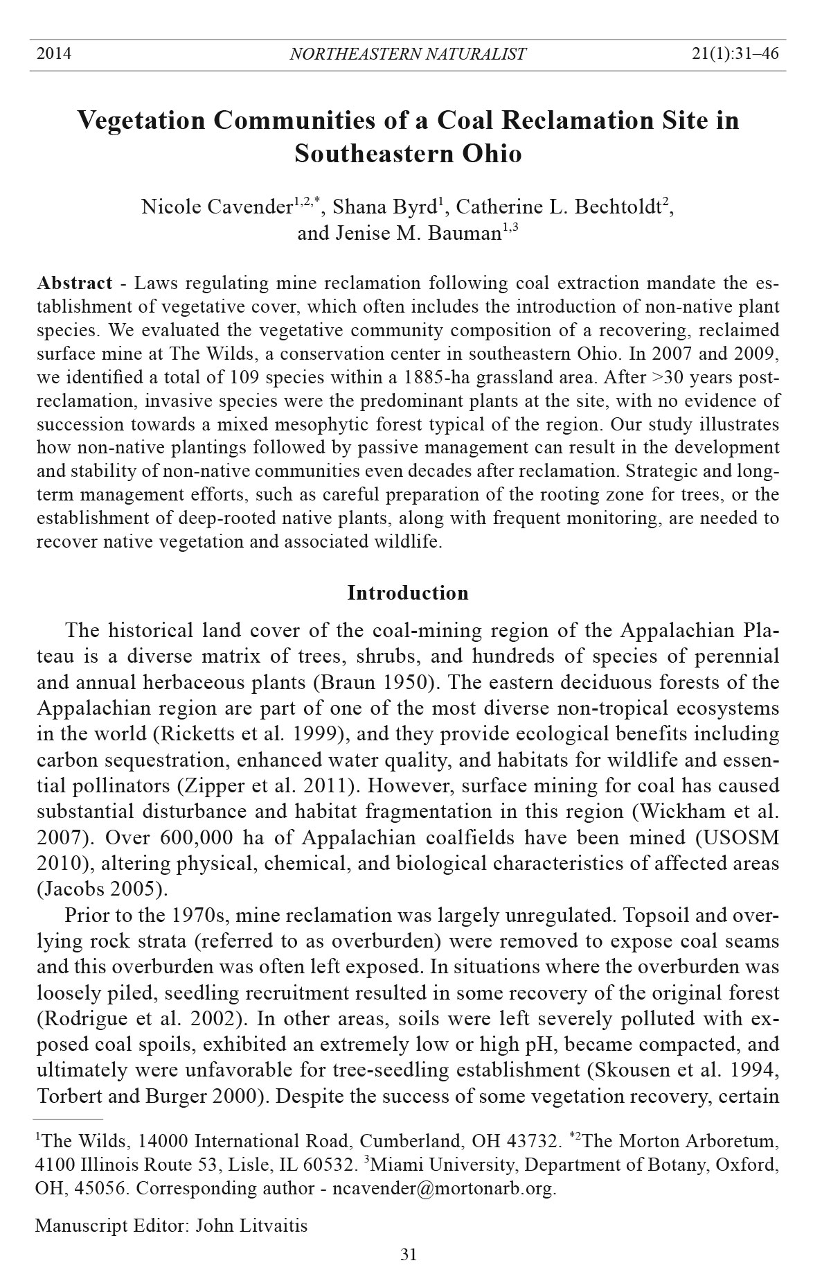
Figure 2. Organizational
diagram outlining the
breakdown of cover class
7, as an example, (25–
50% cover) into the occurrence
weighted cover
(OWC) scale. The geometric
mean of the first
third (25–33.3%) of the
original cover range was
28.7%, and was assigned
to species with a mean
spatial score of 1 or 2.
The geometric mean of
the second third (33.3–
41.7%) was 37.3%, and
was assigned to species
with a mean spatial score
of 3 or 4, and the geometric mean of the final third of the original cover range was 45.6%
(41.7–50%), assigned to species with a mean spatial score of 5.
Northeastern Naturalist Vol. 21, No. 1
N. Cavender, S. Byrd, J.M. Bauman, and C.L. Bechtoldt
2014
35
historical record of occurrence within the Appalachian Plateau (Schwartz 1997).
We defined naturalized plants as species that were not considered to be native but
which have adapted to the Ohio region, do not require human intervention to persist,
and do not pose a threat of being invasive (USDA NRCS 2011). We defined
invasive plants as those that were considered to be non-native to the region and to
have the propensity to invade native ecosystems and displace native plant communities
(Cooperrider et al. 2001).
We evaluated soil characteristics to determine their influence on plant-community
composition. We collected soil samples in 2007 using a soil probe at a 10-cm
depth, and took two samples per 1000-m2 subplot. We dried samples at room temperature,
mixed them, and sent them to Penn State Agricultural Analytical Services
Laboratory for analysis. Soil measurements included: pH; cation exchange capacity
(CEC); concentration (ppm) of phosphorus (P), potassium (K), magnesium (Mg),
calcium (Ca), sulfur (S), zinc (Zn), and copper (Cu); bulk density (g/cm³); and soil
texture (percent sand, silt, and clay).
Statistical analysis
We estimated overall species richness on our study site and used two common, incidence-
based richness estimators, Chao II and Jackknife II, to evaluate the efficacy
of our sampling protocol. We calculated both estimators using the vegan package of
the R statistical program (Oksanen et al. 2005, R Development Core Team 2009). We
used relative OWC values to calculate species abundance using the rank abundance
function (R biodiversity package; Kindt and Coe 2005). We analyzed differences
between relative percent OWC of the most abundant species between 2007 and 2009
using a one-way analysis of variance (ANOVA), followed by a Tukey’s post hoc
test, and determined differences in abundance by plant status (i.e., invasive, native,
and naturalized) by using a one-way ANOVA followed by a Tukey’s post hoc test on
percent OWC. Data were transformed using a log+1 transformation to control for
unequal variances. We considered differences as significant when P ≤ 0.05; we performed
all ANOVAs using R (R Development Core Team 2009).
We used a non-metric multidimensional scaling (NMDS) ordination and a
Bray-Curtis dissimilarity matrix to describe species composition between sampling
years, and to look for associations between the overall plant community
and soil characteristics. We ran the analysis for 100 random starts until the best
solution (lowest stress) was reached. To improve the NMDS ordinations, we
removed rare species that scored less than 0.05% OWC, and the data were square-root
transformed and standardized using Wisconsin double standardization. We used
a permutational multivariate analysis of variance to test for significant differences
between sampling years. We examined how soil characteristics, including
cations (P, K, Mg, Ca, Zn, Cu, S), pH, overall cation exchange capacity (CEC),
bulk density (g/cm³), and soil texture (percentage sand, silt, and clay), influenced
plant-community composition across both years. We standardized soil variables
and fit them onto the NMDS using the envfit function in R. We analyzed the correlation
of soil data with NMDS axes using Mantel tests, and completed both the
Northeastern Naturalist
36
N. Cavender, S. Byrd, J.M. Bauman, and C.L. Bechtoldt
2014 Vol. 21, No. 1
dissimilarity matrices and Mantel tests using the vegan package in R (Oksanen et
al. 2005, R Development Core Team 2009).
Results
Community composition
We encountered a total of 109 species on our study plots (Append ix 1), with 71
species detected in 2007 and 82 in 2009. The Chao II and Jackknife II estimators
both indicated that a slightly greater number of species was likely to exist in the
study location than was detected by our sampling methods (Chao II = 139 ± 13 SE,
Jackknife II = 154 [no SE available]). Species richness averaged 26 ± 2.09 per plot,
with a Shannon diversity index (H') of 1.49 ± 0.07.
Overall, naturalized and invasive species dominated the plant community in
our study plots. Percent cover of naturalized, invasive, and native species varied
between 2007 and 2009 (ANOVA: F = 17.86, df = 5, P < 0.0001). In 2007, naturalized
species dominated (55%), followed by invasive species (41%), and then native
species (4%) (ANOVA: F = 5.77, df = 2, P = 0.004). In 2009, invasive plants had
increased to 75%, followed by naturalized (20%) and native plant species (5%)
(ANOVA: F = 10.88, df = 2, P < 0.0001).
During the 2007 season, Kentucky Blue Grass (32%), Tall Fescue (22%), Bromus
inermis (Smooth Brome; 20%), and Chinese Lespedeza (7.8%) were the most
abundant species, accounting for 75% of the OWC of our study plots (Appendix 1).
Eight additional species were marginally abundant: Bird’s-foot Trefoil (4.2%), Cirsium
arvense (Canada Thistle; 2.8%), Autumn-olive (2.5%), Solidago canadensis
(Canada Goldenrod; 1.4%), Asclepias syriaca (Common Milkweed; 1.1%), Dipsacus
fullonum (Common Teasel; 1%), Melilotus albus (White Sweet Clover; 1%),
and Melilotus officinalis (Yellow Sweet Clover; 1%; Appendix 1). We detected
changes in the four most abundant species between 2007 and 2009 (ANOVA: F =
4.79, df = 7, P < 0.0001; Fig. 3). Specifically, we found increases in the abundance
of Smooth Brome (20.7 to 40.2%) and Chinese Lespedeza from (7.8 to 16.5%) and
decreases in abundance of Kentucky Blue Grass (32 to 13.9%) and Tall Fescue
(21.7 to 4.7%) between the two sampling periods (Fig. 3). Some of the moderately
abundant species increased in OWC between 2007 and 2009: Bird’s-foot Trefoil
(5%), Canada Thistle (3.8%), Canada Goldenrod (2.5%), Yellow Sweet Clover
(2.5%), and Rubus allegheniensis (Common Blackberry, 1.9%) (Appendix 1).
NMDS ordination: Plant community composition and soil associations
NMDS ordination and permutational multivariate analysis of variance revealed
that plant community composition varied between years (F = 2.28, df = 1, P =
0.004; Fig. 4). Kentucky Blue Grass, Canada Goldenrod, and Canada Thistle were
the most common species detected in 2007, whereas Chinese Lespedeza was the
most abundant species when the same plots were sampled in 2009. Soil characteristics
(Table 1) influenced overall plant community composition (2007 and 2009
data combined). The first dimension of the ordination was marginally significant
with regard to sandy soils (r2 = 0.22, P = 0.08) and marginally negatively associated
Northeastern Naturalist Vol. 21, No. 1
N. Cavender, S. Byrd, J.M. Bauman, and C.L. Bechtoldt
2014
37
with silty soils (r2 = 0.25, P = 0.06). The second axis of the ordination was significantly
associated with greater soil Ca concentration (r2 = 0.35, P = 0.01) and greater
soil Cu concentration (r2 = 0.25, P = 0.05; Fig. 4, Table 1). The ordination showed
that Chinese Lespedeza was found most frequently in plots with higher levels of
both Ca and Cu, and silty rather than sandy soil. Canada Goldenrod and Canada
Thistle were found most frequently in plots with sandy soils, where Ca and Cu
concentrations were lower.
Figure 3. The mean relative OWC (%) of the 4 most abundant herbaceous plants (Bromus
inermis, Lespedeza cuneata, Poa pratensis, and Festuca arundinacea) detected in 2007
(dark grey bars) and 2009 (light grey bars). Bars with different letters represent significant
differences at α = 0.05 determined by Tukey’s HSD.
Table 1. Range and mean of soil pH, concentration of micro and macronutrients (ppm),
and texture for 12 vegetation plots located on a coal reclamation site in southeastern Ohio, sampled
30 years after mining activities ceased.
Variable Range Mean
pH 7.3–8.35 8.01
P 2.0–11.0 5
K 78.5–150 105.59
Mg 243.0–589.0 449.73
Ca 4373.5–10,033.0 7544.14
CEC 17.3–22.15 19.2
Zn 0.95–2.15 1.44
Cu 1.9–2.7 2.44
S 9.5–36.5 16.39
Bulk density 1.18–1.30 1.25
Sand 43–72% 57%
Silt 17–47% 32%
Clay 7–23% 11%
Northeastern Naturalist
38
N. Cavender, S. Byrd, J.M. Bauman, and C.L. Bechtoldt
2014 Vol. 21, No. 1
Discussion
After three decades following coal extraction and reclamation, our study showed
that pioneer seedlings were virtually absent and little native recruitment had taken
place. Native plant species from the southeastern Appalachian Plateau region represented
less than 2% of the OWC, so that 98% of the plant cover on the reclaimed
mine area consisted of introduced and naturalized plant species. The most abundant
plants were those used in the original reclamation seed mix (Kentucky Blue Grass,
Tall Fescue, Chinese Lespedeza, Autumn Olive, Yellow Sweet-clover, and Bird’sfoot
Trefoil), species selected for their ability to establish on nutrient-deficient and
compacted soils (Bussler et al. 1984, Torbert and Burger 2000). While our richness
Figure 4. Non-metric multidimensional scaling (NMDS) ordination of vegetation cover
(based on OWC). Larger circles (○) symbolize plots sampled in 2007, and triangles (Δ)
symbolize the same plots sampled in 2009. The pattern reveals that plant communities
differed between the 2 years (permutational multivariate analysis of variance: P = 0.004).
Small circles ( ͦ ) represent OWC values for plant species detected during the entire study
period, with the most abundant species’ names appearing on the ordination. Plot vectors
indicate strength and direction of the strongest correlations between soil variables and plant
species detected. Soil texture (silt versus sand) as well as soil calcium (Ca) and soil copper
(Cu) concentrations significantly influenced plant community comp osition.
Northeastern Naturalist Vol. 21, No. 1
N. Cavender, S. Byrd, J.M. Bauman, and C.L. Bechtoldt
2014
39
estimators showed that species richness is likely slightly higher than our estimates,
we are confident our vegetation surveys reflected the characteristics of the plant
community on our study plots. Dominant herbaceous cover is likely inhibiting
the recruitment of native species, resulting in grasslands in arrested succession
(Pritekel et al. 2006, Vaness and Wilson 2007). These invasive and naturalized species
further create barriers for native recruitment by altering nutrient cycles, water
tables, and soil microbial communities from their natural condition (Vitousek 1990,
Wedin and Tilman 1996).
Although previous studies have reported arrested succession in reclaimed mine
areas (Holl 2002), it is remarkable how little the plant community composition has
changed since introduction of the species included in the reclamation seed mix,
given the time that has passed. Reasons for lack of succession to a native mixed-mesophytic
forest community include: (1) the lack of a native seed bank on the study
area due to mining activities, (2) limited tree recruitment because of the distance to
the nearest remnant forest edge, (3) soil compaction inhibiting seedling establishment,
and (4) dense herbaceous canopies that hinder seedling and plant survival.
Another factor may be that the soil characteristics we documented at our study site
match those of a weathering, younger soil, which may not yet be conducive to tree
and shrub establishment (Skousen et al. 2009). Others have also reported a lack
of re-invasion by native tree species at similar SMCRA sites characterized by soil
compaction and invasive ground cover (reviewed in Burger 2011). Even when sites
are purposefully replanted with native trees, establishment and recolonization by
native species can remain low (Simmons et al. 2008, Zipper et a l. 2011).
We expected the vegetation community to change over the long term, yet anticipated
it would remain relatively constant over the short term (between sampling in
2007 and 2009). However, our data showed a shift in community composition and
species dominance in the short term. The relative abundances of the four dominant
species increased or decreased significantly (Fig. 3), and community composition
showed different patterns between sampling years (Fig. 4). These results show that
despite the long-term trend of seed-mix species persisting, the plant community
experienced short-term changes in community composition at least to some extent.
These changes may have been due to shifts in the weather that allowed one species
to outcompete another in the short term. Further study could show what influence
this kind of short-term change has on the overall trajectory of the community.
Soil microhabitat variation influenced plant community composition. Distributions
of some dominant species (native, naturalized, and invasive) on our study
plots were influenced by soil characteristics, specifically calcium and copper concentration,
and levels of silt and sand. In reclaimed mine areas, soil is generally nutrient-
poor and heterogeneous, due to mining and reclamation activities (Boruvka
and Kozak 2001, Jacinthe and Lal 2006). Reclaimed mine soils can exhibit zones of
pH extremes and nutrient, metal, and organic matter concentrations can be patchy
(Boruvka and Kozak, 2001, Mummey et al. 2002). Despite the community being
overwhelmingly influenced by the reclamation species used, it is interesting to note
that soil properties play a significant role in determining local species’ distributions.
Northeastern Naturalist
40
N. Cavender, S. Byrd, J.M. Bauman, and C.L. Bechtoldt
2014 Vol. 21, No. 1
Further study to examine how local soil conditions affect reclamation plant communities
may provide insight on how local soil characteristics can be exploited to
reach restoration goals.
Our study area was dominated by invasive and naturalized species even after a
relatively long period of recovery, illustrating how replanting based on reclamation
regulations followed by passive management may not result in the re-establishment
of the native plant community. Other approaches to reclamation have had better results.
For example, the Forestry Reclamation Approach incorporates proper substrate
selection, and soil preparation to a depth of >1 m to create a suitable rooting zone
at the time of reclamation. In addition, this approach includes selection of valuable
tree species and appropriate herbaceous vegetation (Zipper et al. 2011), and use of
the protocol has resulted in healthy tree establishment on SMCRA landscapes (Casselman
et al. 2006, Groninger et al. 2007, McCarthy et al. 2008, Skousen et al 2009).
Another approach is to establish a diverse prairie plant community comprised of
herbaceous species that form extensive root systems. This approach is currently being
explored at The Wilds. As soil productivity, fertility, and organic matter increase
(Fornara and Tilman 2009, Tilman et al. 2006), diversity at many trophic levels also
increases, including the addition of pollinators and seed dispersers that will lead to
the succession of native forest (Cavender-Bares and Cavender 2010).
Coal mining has impacted over 600,000 ha of land in the Appalachian region
of the United States and continues at a rate of an additional >10,000 ha per year
(Zipper et al. 2011). Our study at The Wilds, in Muskingum County, OH, shows
that following current reclamation guidelines and passive management protocols
does not result in a native plant community—even after 30 years. We suggest that
more active management and proven restoration initiatives are required to promote
natural recovery that more closely resembles historic vegetation communities and
provide the ecosystem services and support the diversity and trophic levels of the
native ecosystem.
Acknowledgments
This project was supported by a partnership with Conservation Centers for Species Survival
and funded in part by the National Fish and Wildlife Foundation. The authors would
like to thank Corine Peugh for her assistance with the manuscript, Jeff Lombardo for his
field assistance as well as his contribution to developing OWC, Kristen Smock for her contribution,
Robert Ford for his field assistance, Al Parker for his help with mining history, and
David Brandenburg, Bill McShea, Nina Sengupta, and the anonymous reviewers for their
helpful suggestions on the manuscript. We would also like to thank Evan Blumer for his
leadership at The Wilds during this project.
Literature Cited
Boruvka, L., and J. Kozak. 2001. Geostatistical investigation of a reclaimed dumpsite soil,
with emphasis on aluminum. Soil and Tillage Research 59:115–126.
Braun, E.L. 1950. Deciduous Forests of Eastern North America. McGraw-Hill Book Company,
Inc., New York, NY. 596 pp.
Northeastern Naturalist Vol. 21, No. 1
N. Cavender, S. Byrd, J.M. Bauman, and C.L. Bechtoldt
2014
41
Burger, J.A. 2011. Sustainable mined land reclamation in the eastern US coalfields: A
case for an ecosystem reclamation approach. Pp. 113–141, In R.I. Barnhisel (Ed.). The
American Society of Mining and Reclamation Proceedings: Sciences Leading to Success.
Lexington, KY.
Bussler, B.H., W.R. Byrnes, P.E. Pope, and W.R. Caney. 1984. Properties of minesoil reclaimed
for forestland use. Soil Science Society of America Journal 48:178–184.
Carr, S.C., K.M. Robertson, and R.K. Peet. 2010. A vegetation classification of fire-dependent
pinelands of Florida. Castanea 75:153–189.
Casselman, C.N., T.R Fox, J.A. Burger, A.T. Jones, and J.M. Galbraith. 2006. Effects of
silvicultural treatments on survival and growth of trees planted on reclaimed mine lands
in the Appalachians. Forest Ecology and Management 223:403–414.
Cavender-Bares, J., and N. Cavender 2010. Phylogenetic structure of plant communities
provides guidelines for restoration. Pp.119–129, In S. Greipsson (Ed.). Restoration
Ecology. Jones and Bartlett Publishers, Inc., Boston, MA. 408 pp.
Cooperrider, T.S., A.W. Cusick, and J.T. Kartesz. 2001. Seventh Catalog of the Vascular
Plants of Ohio. Ohio State University Press, Columbus, OH. 195 pp.
Fornara, D.A., and D. Tilman. 2009. Ecological mechanisms associated with the positive
diversity-productivity relationship in N-limited grassland. Ecology 90:408–418.
Gleason, H., and A. Cronquist. 1991. Manual of Vascular Plants of Northeastern United
States and Adjacent Canada, 2nd Edition. The New York Botanical Garden, Bronx, NY.
910 pp.
Groninger, J., J. Skousen, P. Angel, C. Barton, J. Burger, and C. Zipper. 2007. Mine reclamation
practices to enhance forest development through natural succession. USOSM.
Forest Reclamation Advisory No. 5. Available online at http://arri.osmre.gov/fra.htm.
Accessed 18 March 2012.
Holl, K. 2002. Long-term vegetation recovery on reclaimed coal surface-mines in the eastern
USA. Journal of Applied Ecology 39:960–970.
Jacinthe, P.A., and R. Lal. 2006. Spatial variability of soil properties and trace gas fluxes in
reclaimed mine land of southeastern Ohio. Geoderma 136:598–608.
Jacobs, D. 2005. American Chestnut as a future resource to enhance reclamation productivity.
Pp. 512–522, In R.I. Barnhisel (Ed.). Proceedings of the American Society of Mining
and Reclamation 22nd Annual National Conference. Morgantown, WV.
Kindt, R., and R. Coe. 2005. Tree diversity analysis. A manual and software for common
statistical methods for ecological and biodiversity studies. World Agroforestry Centre
(ICRAF), Nairobi. Available online at http://www.worldagroforestry.org/downloads/
publications/PDFs/B13695.pdf. Last accessed February 2014.
McCarthy, B.C., J.M. Bauman, and C.H. Keiffer. 2008. Mine-land reclamation strategies
for the restoration of American Chestnut. Ecological Restoration 26:292–294.
Mummey, D.L., P.D. Stahl, and J.S. Buyer. 2002. Soil microbiological properties 20 years
after surface mine reclamation: Spatial analysis of reclaimed and undisturbed sites. Soil
Biology and Biochemistry 34:1717–1725.
Ohio Department of Natural Resources (ODNR). 2011. A citizens guide to mining and
reclamation in Ohio. Available online at http://ohiodnr.com/Portals/11/publications/pdf/
citizens_guide.pdf. Accessed 18 March 2012.
Ohio Department of Natural Resources Division of Reclamation (ODNR-DR). 1983. Coal
mining and reclamation permit application. Central Ohio Coal Company, Columbus, OH.
Oksanen, J., R. Kindt, and R.B. O’Hara. 2005. Vegan: Community ecology package, version
1.6.9. Available online at http://cc.oulu.fi/~jarioksa/. Accessed 18 March 2012.
Northeastern Naturalist
42
N. Cavender, S. Byrd, J.M. Bauman, and C.L. Bechtoldt
2014 Vol. 21, No. 1
Peet, R.K, T.R Wentworth, R. Thomas, and P.S. White. 1998. A flexible, multipurpose
method for recording vegetation composition and structure. Castanea 63:262–274
Peugh, C.M., J.M. Bauman, and S.M. Byrd. 2013. Restoring remnant hardwood forest
impacted by surface mining for coal through removal of the invasive Tree-of-Heaven
(Ailanthus altissima). Pp. 208–222, In R.I. Barnhisel (Ed.). The 30th Annual Meeting of
the American Society of Mining and Reclamation, 1–7 June 2013, Lara mie, WY.
Poncelet, D.M., N. Cavender, T.J. Cutright, and J.M. Senko. 2014. Environmental Monitoring
and Assessment 186:1917–1929.
Pritekel, C., A. Wittemore-Olson, N. Snow, and J.C. Moore. 2006. Impacts from invasive
plant species and their control on the plant community and belowground ecosystem at
Rocky Mountain National Park, USA. Applied Soil Ecology 32:132–141.
R Development Core Team 2009. R: A language and environment for statistical computing.
R Foundation for Statistical Computing, Vienna, Austria. Available online at http://
www.R-project.org. Accessed 18 March 2012.
Ricketts, T.H., E. Dinerstein, D.M. Olson, C.J. Loucks, W. Eichbaum, D. DellaSalla, K.
Kavanaugh, P. Hedao, P. Hurley, K. Carney, R. Abell, and S. Walters. 1999. Terrestrial
Ecoregions of North America: A Conservation Assessment. Island Press, Washington,
DC. 508 pp.
Rodrigue, J.A., J.A. Burger, and R.G. Oderwald. 2002. Forest productivity and commercial
value of pre-law reclaimed mined land in the eastern United States. Northern Journal of
Applied Forestry 19:106–114.
Schwartz, M. 1997. Defining native plants. Pp. 8–11, In J. Luken and J. Theiret (Eds.). Assessment
and Management of Plant Invasions. Springer, New York, NY. 324 pp.
Simmons, J., W. Currie, K.N. Eshleman, K. Kuers, S. Monteleone, T.L. Negley, B. Pohlad,
and C. Thomas. 2008. Forest to reclaimed land-use change leads to altered ecosystem
structure and function. Ecological Applications 18:104–118.
Skousen, J.G., C.D. Johnson, and K. Garbutt. 1994. Natural revegetation of 15 abandoned
mine land sites in West Virginia. Journal of Environmental Quality 23:1224–1230.
Skousen, J., J. Gorman, E. Pena-Yewtukhiw, J. King, J. Stewart, P. Emerson, and C. De-
Long. 2009. Hardwood tree survival in heavy groundcover on reclaimed land in West
Virginia: Mowing and ripping effects. Journal of Environmental Quality 38:1400–1409.
Surface Mining Control and Reclamation Act (SMCRA). 2006. Public Law 95-87. Surface
Mining Control and Reclamation Act of 1977. US Code, Title 30, Chapter 25.
USOSM, Washington, DC. Available online at http:www.law.cornell.edu/uscode/30/
usc_sup_01_30_10_25_20_V.html. Accessed 18 March 2012.
Tilman, D., J. Hill, and C. Lehman. 2006. Carbon-negative biofuels from low-input highdiversity
grassland biomass. Science 314:1598–1600.
Torbert, J.L., and J.A. Burger. 2000. Forest land reclamation. Pp. 371–378, In R.I. Barnhisel,
R.G. Darmody, and W.L. Daniels (Eds.). Reclamation of Drastically Disturbed
Lands. Agronomy Monograph No. 41. Soil Science Society of America, Madison, WI.
United States Department of Agriculture Natural Resources Conservation Service (USDA
NRCS). 2011. The PLANTS database. National Plant Data Team, Greensboro, NC.
Available online at http://plants.usda.gov. Accessed 18 March 2012.
US Office of Surface Mining (USOSM). 2010. Annual evaluation reports for states and
tribes. US Department of the Interior, Washington, DC. Available online at http:www.
osmre.gov/Reports/EvalInfo/EvalInfo.shtm. Accessed 13 December 2010.
Vaness, B.M., and S.D. Wilson. 2007. Impact and management of Crested Wheatgrass
(Agropyron cristatum) in the northern Great Plains. Canada Journal of Plant Science
87:1023–1028.
Northeastern Naturalist Vol. 21, No. 1
N. Cavender, S. Byrd, J.M. Bauman, and C.L. Bechtoldt
2014
43
Vitousek, P.M. 1990. Biological invasions and ecosystem processes: Towards an integration
of population biology and ecosystem studies. Oikos 57:7–13 .
Wedin, D.A., and D. Tilman. 1996. Influence of nitrogen loading and species composition
on the carbon balance of grasslands. Science 274:1720–1723.
Wickham, J.D., K.H. Riitters, T.G. Wade, M. Coan, and C. Homer. 2007. The effect of
Appalachian mountaintop mining on interior forest. Landscape Ec ology 22:179–187.
Zipper, C.E., J.A. Burger, J.G. Skousen, P.N. Angel, D. Barton, V. Davis, and J.A. Franklin.
2011. Restoring forests and associated ecosystem services on Appalachian coal surfacemines.
Environmental Management 47:751–765.
Northeastern Naturalist
44
N. Cavender, S. Byrd, J.M. Bauman, and C.L. Bechtoldt
2014 Vol. 21, No. 1
Appendix 1. Species relative abundance, reported as occurrence-weighted cover (OWC),
for twelve 100-m2 vegetation plots established on a coal reclamation site in southeastern
Ohio, sampled in 2007 and 2009, 30 years after mining activities ceased. Species are listed
by their functional group and native status (N = native, NZ = naturalized, and I = invasive).
Native OWC (%)
Species name Common name status '07 '09
Forbs and vines
Achillea millefolium L. Yarrow N <1 <1
Ageratina altissima (L.) R.M. King White Snakeroot N 0 <1
& H Rob
Allium vineale L. Field Garlic NZ <1 0
Amaranthus hybridus L. Smooth Pigweed NZ 0 <1
Amaranthus retroflexus L. Rough Pigweed NZ <1 0
Amaranthus spinosus L. Spiny Amaranth NZ 0 <1
Ambrosia artemisiifolia L. Common Ragweed N <1 <1
Ampelamus albidus (Nutt.) BrittonA Honey-vine N 0 <1
Apocynum cannabinum L. Indian-hemp N <1 <1
Arctium lappa L. Great Burdock NZ <1 0
Arctium minus Bernh. Common Burdock NZ <1 0
Asclepias syriaca L. Common Milkweed N 1.1 <1
Asclepias tuberosa L. Butterfly-weed N <1 <1
Barbarea vulgaris R. Br. Yellow Rocket NZ <1 <1
Bidens polylepis S.F. Blake Ozark Tickseed Sunflower N 0 <1
Carduus nutans L. Nodding Thistle I 0 <1
Chrysanthemum leucanthemum L.B Ox-eye Daisy I <1 <1
Cichorium intybus L. Chicory NZ <1 0
Cirsium arvense (L.) Scop. Canada Thistle I 2.8 3.8
Cirsium discolor (Muhl. ex Willd.) Spreng. Field Thistle N <1 0
Cirsium pumilum (Nutt.) Spreng. Pasture Thistle N <1 0
Cirsium vulgare (Savi) Ten. Bull Thistle NZ <1 <1
Clinopodium vulgare (L.)C Wild Basil N <1 <1
Convolvulus arvensis L. Common Bindweed I <1 <1
Daucus carota L. Queen Anne’s Lace I <1 <1
Dianthus armeria L. Deptford Pink NZ <1 0
Dipsacus fullonum L. Common Teasel I 1 <1
Epilobium angustifolium L. Fireweed N 0 <1
Erechtites hieracifolia (L.) Raf. ex DC. Pilewort N 0 <1
Erigeron annuus (L.) Pers. Daisy Fleabane N <1 0
Eupatorium altissimum L. Tall Thoroughwort N <1 0
Euthamia graminifolia (L.) Nutt.D Flat-topped Goldenrod N <1 <1
Galium mollugo L. White Bedstraw NZ <1 <1
Glechoma hederacea L. Ground Ivy NZ <1 0
Hackelia virginiana (L.) I.M. Johnst. Common Stickseed N 0 <1
Hypericum perforatum L. Common St. Johnswort NZ < 1 <1
Lactuca serriola L. Prickly Lettuce NZ <1 0
Lepidium campestre (L.) R. Br. Field Pepper-grass NZ <1 0
Lepidium virginicum L. Virginia Pepper-grass NZ 0 <1
Northeastern Naturalist Vol. 21, No. 1
N. Cavender, S. Byrd, J.M. Bauman, and C.L. Bechtoldt
2014
45
Native OWC (%)
Species name Common name status '07 '09
Lobelia inflata L. Indian-tobacco N 0 <1
Lonicera japonica Thunb. Japanese Honeysuckle I <1 0
Oxalis stricta L. Common Wood-sorrel N <1 <1
Parthenocissus quinquefolia (L.) Planch. Virginia Creeper N <1 <1
Penstemon digitalis Nutt. ex Sims Foxglove Beardtongue N 0 <1
Physalis longifolia var. subglabrata Smooth Ground-cherry N <1 <1
(Mack. & Bush) Cronquist
Phytolacca americana L. American Pokeweed N 0 <1
Pilea pumila (L.) A. Gray Common Clearweed N 0 <1
Plantago lanceolata L. English Plantain NZ 0 <1
Polygonum convolvulus L. False Buckwheat NZ <1 0
Potentilla palustris (L.) Scop. Marsh Cinquefoil N <1 0
Potentilla recta L. Sulphur Cinquefoil NZ <1 0
Prunella vulgaris L. Self-Heal N 0 <1
Rumex crispus L. Curly Dock NZ 0 <1
Solanum carolinense L. Horsenettle N <1 <1
Solanum nigrum L. Black Nightshade N <1 <1
Solidago canadensis L. Canada Goldenrod N 1.4 2.5
Sonchus arvensis L. Field Sow-thistle NZ <1 0
Sonchus asper (L.) Hill Prickly Sow-thistle NZ < 0
Spiranthes cernua (L.) Rich. Nodding Ladies’-tresses N 0 <1
Stellaria media (L.) Vill. Common Chickweed NZ 0 <1
Symphyotrichum ericoides (L.) G.L. White Heath Aster NZ 0 <1
Nesom
Taraxacum officinale Weber ex F.H. Common Dandelion NZ <1 <1
Wigg.
Thymus pulegioides L. Creeping Thyme NZ <1 0
Toxicodendron radicans (L.) Kuntze Poison Ivy N <1 <1
Tragopogon lamottei RouyE Jack-go-to-bed-at-noon NZ <1 0
Trifolium repens L. White Clover NZ 0 <1
Verbascum blattaria L. Moth Mullein NZ 0 <1
Verbascum thapsus L. Common Mullein NZ 0 <1
Verbena urticifolia L. White Vervain N <1 <1
Vernonia fasciculata Michx. Prairie Ironweed N 0 <1
Vitis aestivalis Michx. Summer Grape N <1 <1
Graminoids
Agrostis gigantea Roth Redtop NZ 0 <1
Andropogon gerardii Vitman Big Bluestem N 0 <1
Andropogon virginicus L. Common Broom-sedge N <1 <1
Bromus inermis Leyss. Smooth Brome I 20.7 40.2
Dactylis glomerata L. Orchard Grass NZ <1 <1
Danthonia spicata (L.) P. Beauv. ex Roem. Poverty Oat Grass N <1 0
& Schult.
Elymus repens (L.) GouldF Quack Grass NZ <1 <1
Festuca arundinacea Schreb.G Tall Fescue NZ 21.7 4.7
Northeastern Naturalist
46
N. Cavender, S. Byrd, J.M. Bauman, and C.L. Bechtoldt
2014 Vol. 21, No. 1
Native OWC (%)
Species name Common name status '07 '09
Juncus spp. Rushes N <1 0
Panicum capillare L. Witch Grass N 0 <1
Phleum pratense L. Timothy NZ 0 <1
Poa pratensis L. Kentucky Blue Grass NZ 32 13.9
Setaria faberi R. A. W. Herrm. Nodding Foxtail Grass NZ 0 <1
Setaria viridis (L.) P. Beauv. Green Foxtail Grass NZ 0 <1
Sorghastrum nutans (L.) Nash Indian Grass N 0 <1
Legumes
Coronilla varia L. Crown-vetch I <1 0
Gleditsia triacanthos L. Honey-locust N <1 <1
Lespedeza cuneata (Dumont) G. Don Chinese Lespedeza I 7.8 16.5
Lotus corniculatus L. Bird’s-foot-trefoil I 4.2 5
Medicago lupulina L. Black Medick NZ <1 0
Melilotus albus Medik. White Sweet-clover I 1.16 4.6
Melilotus officinalis (L.) Pall. Yellow Sweet-clover I 1 2.5
Trifolium campestre Schreb. Low Hop Clover NZ 0 <1
Trifolium hybridum L. Alsike Clover NZ <1 <1
Trifolium pratense L. Red Clover NZ <1 <1
Woody plants
Ailanthus altissima (Mill.) Swingle Tree-of-heaven I <1 <1
Crataegus spp. Hawthorns N <1 0
Elaeagnus umbellata Thunb. Autumn-Olive I 2.5 1
Fraxinus americana L. White Ash N <1 0
Lonicera maackii (Rupr.) Maxim. Amur Honeysuckle I 0 <1
Lonicera morrowii A. Gray Morrow’s Honeysuckle I <1 <1
Prunus serotina Ehrh. Wild Black Cherry N 0 <1
Robinia pseudoacacia L. Black Locust N 0 <1
Rosa carolina L. Pasture Rose N 0 <1
Rosa multiflora Thunb. ex Murray Multiflora Rose I <1 <1
Rubus allegheniensis Porter Common Blackberry N <1 1.94
Rubus occidentalis L. Black Raspberry N <1 <1
Ulmus americana L. White Elm N 0 <1
ASyn. Cynanchum laeve (Michx.) Pers.
BSyn. Leucanthemum vulgare Lam.
CSyn. Satureja vulgaris (L.) Fritsch
DSyn. Solidago graminifolia (L.) Salish
ESyn. Tragopogon pratensis (L.)
FSyn. Agropyron repens (L.) P. Beauv., Elytrigia repens (L.) Desv. ex B.D. Jacks.
GSyn. Lolium arundinaceum (Schreb.) Darbysh., Schedonorus phoenix (Scop.) Holub.