Observations on the Expansion of a Relict Population of Eastern
Oysters (Crassostrea virginica) in a Maine Estuary: Implications
for Climate Change and Restoration
Peter Foster Larsen, Karen A. Wilson, and Dana Morse
Northeastern Naturalist, Volume 20, Issue 4 (2013): N28–N32
Full-text pdf (Accessible only to subscribers. To subscribe click here.)
Access Journal Content
Open access browsing of table of contents and abstract pages. Full text pdfs available for download for subscribers.
Current Issue: Vol. 30 (3)

Check out NENA's latest Monograph:
Monograph 22


2013 Northeastern Naturalist Notes Vol. 20, No. 4
N28
P.F. Larsen, K.A. Wilson, and D. Morse
Observations on the Expansion of a Relict Population of Eastern
Oysters (Crassostrea virginica) in a Maine Estuary: Implications
for Climate Change and Restoration
Peter Foster Larsen1,*, Karen A. Wilson2, and Dana Morse3
Abstract - The Gulf of Maine has undergone dramatic physiographic and oceanographic changes
over the last several millenia resulting in some unusual biogeographic consequences. One is that
there are pockets of Virginian species, including Crassostra virginica (Eastern Oyster), that survive
in isolated warm water pockets, usually at the heads of estuaries. These small and vulnerable populations
need documentation, protection, and restoration in order to preserve their genetic characteristics
and ecological services. In this contribution, we describe the circumstances whereby tidal restoration
made available 2.5 linear km of new habitat area to the relict oyster population of the Marsh River,
ME, the northernmost documented native oyster population in the United States. Oysters recruited
to the new habitat quickly, demonstrating the restoration potential of isolated, relict populations. The
resultant larger population size and areal extent should provide increased stability and survivability of
the oyster and its associated community. These observations have implications for both the restoration
potential of relict oyster populations and the consequences of climate change.
Eight thousand years ago, the Gulf of Maine was a very different place than it is today
(Bousfield and Thomas 1975, Larsen 2004, Shaw et al. 2002). Sea level was lower, and tides
were minimal or non-existent, resulting in a Gulf that was lagoonal in nature (Campbell
1986). This condition allowed for warm summer water temperatures that were suitable for
colonization by warm temperate (Virginian) species from the south. During this hypsothermal
period, the distribution of warm temperate species was continuous from the mid-Atlantic
to the Gulf of St. Lawrence (Bousfield and Thomas 1975). As sea level rose in succeeding
millennia and larger and larger tides developed (Grant 1970, Greenberg et al. 2012), the
surface waters of the Gulf cooled and warm temperate species were increasingly restricted
in their range within the Gulf of Maine. The populations of several species became disjunct
from the main population centers in the mid-Atlantic region, and from one another, with the
result that groupings of warm temperate species are now limited to isolated pockets, called
Virginian refugia, where summer water temperatures in most, but not all, years still reach
levels (mid-20s °C) sufficient for the reproduction of these species with southern affinities.
The Virginian refugia are usually located near the heads of estuaries and are largely confined
to mid-coast Maine, particularly to the complex Sheepscot estuary and its tributaries (Fig. 1).
Crassostrea virginica Gmelin (Eastern Oyster) is the most important and characteristic of
these species. These are ancient, natural populations of oysters that were present well before
the introduction of C. virginica to a few lower estuarine sites by the aquaculture industry in
the early 1970s. DNA analyses are anticipated to establish the genetic relationship of the
natural and aquacultural oysters.
There is a critical need for increased knowledge of the native oyster populations in
the Gulf of Maine because they are at risk for several reasons (Beck et al. 2009). Several
populations are surely as yet undiscovered and undocumented and, hence, can be destroyed
unknowingly. The population sizes are small and are located in confined habitats where
1Bigelow Laboratory for Ocean Sciences, PO Box 380, 60 Bigelow Drive, East Boothbay, ME 04544.
2Department of Environmental Science and Aquatic Systems Group, University of Southern Maine,
Gorham, ME 04038. 3Maine Sea Grant College Program and University of Maine Cooperative Extension,
Darling Marine Center, Walpole, ME 04573. *Corresponding author – plarsen@bigelow.org.
Notes of the Northeastern Naturalist, Issue 20/4, 2013
N29
2013 Northeastern Naturalist Notes Vol. 20, No. 4
P.F. Larsen, K.A. Wilson, and D. Morse
they can be extinguished by relatively minor environmental perturbations including harvesting,
chemical spills, upland erosion, hydrodynamic alterations, and disease. As these
relict populations have been isolated from the main populations for a long time, perhaps
hundreds or even thousands of years, these populations may provide a divergent genetic
resource that will be significant in the face of climate change. In addition, it is important
to realize that oysters and their associated faunal community are, or are potentially, the
characteristic community of upper estuaries in Maine. These are the same areas where we
would expect the first signals of climate change to be observed in the coastal zone because
the freshwaters entering the estuaries will warm faster than the tidally mixed seawater entering
estuarine mouths and because the hydrology of these systems is highly responsive
to change in the timing and magnitude of freshwater inputs (C. Hebson, Maine Department
of Transportation, Augusta, ME, pers. comm.). These oyster communities will provide a
sensitive sentinel of climate change. Thus, the identification, protection, restoration, and
expansion of the relict Maine oyster populations will have important implications for the
biodiversity and ecological services in Maine estuaries (Coen et al. 2007) both currently
and in response to future climate change.
The Marsh River/Deer Meadow Brook oyster population. The Marsh River/Deer Meadow
Brook oyster population is considered the northernmost native oyster population in the
United States (Cowger 1975). The existence of this site is well documented, although little is
known about the ecology of the system or the biology of the resident oysters. Other relict oyster
populations are suspected to exist and are being explored. There was a commercial oyster
harvest in the Marsh River until the 1960s (Cowger 1975). The area was declared a Maine
Department of Marine Resources Conservation Area in 1968 to protect the oyster population
from overharvesting, and much of the surrounding land is now undeveloped and protected by
public and private conservation easements. The site has been registered by the Maine Critical
Areas Program (Cowger 1975) because of the presence of native oysters. The oyster, together
with a concentration of other natural attributes in this relatively undeveloped area, led to
the site’s nomination as a NOAA estuarine sanctuary (MSPO 1981). A 2008 video survey of
the area by Larsen and Barker (unpublished) found healthy, multi-year-class populations of
oysters, many growing vertically, in high densities wherever the bottom was suitable along
a 3.25-km reach of the river. Nevertheless, we consider this population to be at risk because
of the limited bottom available for oyster settlement and due to the small areal extent of the
oyster’s distribution. The specific distribution and abundance of natural oysters in the Marsh
River system have not been documented due, in part, to lack of visibility in the turbid water.
The Formation of Sherman Marsh. In 1935, a causeway was constructed to carry US
Route 1 across the upper section of the Marsh River (Fig. 1). This barrier terminated the
flow of salt water to the upper 2.5 km of the Marsh River and converted the former intertidal
marshland into the 90-ha Sherman Lake. Over seven inches of rain fell in the vicinity
on 8–9 October 2005. This event, with a return period of about 50 years (C. Hebson, pers.
comm.), breached the causeway causing Sherman Lake to drain and allowing limited tidal
flow to return once again after a 70-year hiatus. Subsequently, other storm events, especially
the Patriots Day storm of 16 April 2007, lowered and widened the sill remaining at
the causeway and significantly increased tidal flow above the causeway. Finally, restoration
efforts opened and stabilized the breach until the natural tidal exchange was almost completely
reestablished in fall 2008. The return of tidal flow to Sherman Marsh was therefore
a three-stage process. In the fall of 2005, the breach allowed limited tidal exchange with
an approximately 1-m tide at the upper half of the normal natural tidal range. By the fall
of 2007, the additional erosion of the causeway resulted in a 1.5-m tide. Finally, in the fall of
2008, permanent stabilization of the marsh outlet created a nearly complete tidal exchange
2013 Northeastern Naturalist Notes Vol. 20, No. 4
N30
P.F. Larsen, K.A. Wilson, and D. Morse
with the exception that, due to a hard control elevation at the outlet, the water drains to only
1.23 m below mean sea level in the marsh, or approximately 0.4 m higher than the external
mean low water (NAVD) (C. Hebson, pers. comm.).
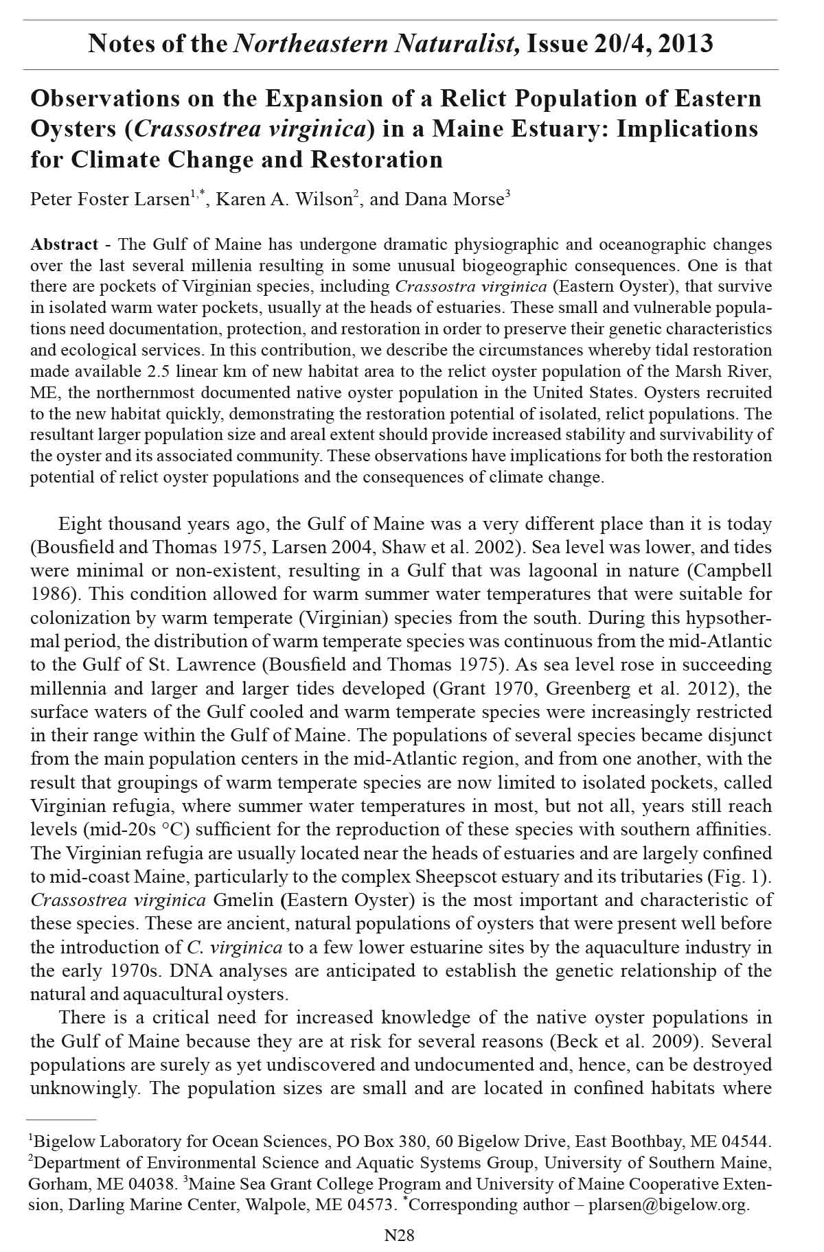
Figure 1. Location of the relict Marsh River oyster population, indicating the Marsh River, Deer
Meadow Brook, and Sherman Marsh, the former Sherman Lake. The shaded area represents the extent
of the newly restored Sherman Marsh.
N31
2013 Northeastern Naturalist Notes Vol. 20, No. 4
P.F. Larsen, K.A. Wilson, and D. Morse
Recruitment and Establishment of Oysters in Sherman Marsh. On 10 October 2008, one
of us (K.A. Wilson) noticed young oysters on a rock ledge approximately 1.5 km upstream
from the breached causeway (Fig. 2). These individuals were found dead the following
year when the increasing tidal range resulted in the site becoming intertidal. Examination
of photographs of these oysters indicated that they were two or three years old. If that age
estimation is correct, the oysters recruited from the main Marsh River population in summer
of 2007 after the Patriot’s Day storm of April 2007 or even in summer 2006 after the
initial breach in the autumn of 2005. Further sampling and measurement will be undertaken
to better fix the date of initial recruitment as well as the pat tern of continuing recruitment.
Subsequent surveys in 2010 and 2011 determined that oysters are now established on
nearly every piece of suitable substrate in Sherman Marsh, including ledges, rocks, logs,
gravel pockets, and miscellaneous debris. We are presently unable to estimate the size of
the Sherman Marsh oyster population because of the very patchy distribution of the suitable
habitat. The total amount of new habitat in Sherman Marsh, however, unquestionably
remains small, perhaps only tens of square meters. We expect that the amount of suitable
oyster habitat in Sherman Marsh will increase over time, however, as tidal action continues
to flush out soft sediment associated with 70 years of lacustrine conditions. Salinity and
temperature far up the river in Sherman Marsh are suitable for oyster survival and growth.
We have observed salinities of 24 psu and temperatures of over 23 °C in August 2010.
The opening of this 2.5 linear km of potential oyster habitat, with conducive salinities and
temperatures, has increased the available space for the Marsh River/Deer Meadow Brook
native oyster population by 75%. The limiting factor remains the restricted and irregular
Figure 2. Young Crassostrea virginica (Eastern Oyster) growing in Sherman Marsh on a subtidal rock
ledge 1.5 km above the original causeway as photographed in October 2008. (Photograph © K.A.
Wilson).
2013 Northeastern Naturalist Notes Vol. 20, No. 4
N32
P.F. Larsen, K.A. Wilson, and D. Morse
distribution of firm substrates for oyster sets, which suggests that the site may be suitable
for restoration projects to accelerate the development of favorable oyster bottom.
In summary, the breaching of the Marsh River causeway converted 2.5 km of lacustrine
environment into a marine environment. Salinities and temperature are suitable for oyster
set and survival and, indeed, oysters recruited to the new habitat a very short time after
the causeway burst. Population development is limited at present, however, by the sparse
firm substrate available. The transition is ongoing, and we observe a natural progression
towards increasing oyster habitat. The process could be greatly accelerated by restoration
efforts targeted at returning the estuary to its natural pre-1935 state, thereby conserving and
protecting this northernmost native Eastern Oyster population in the United States. This
contribution documents that the breach of the US Route 1 causeway opened new habitat for
the relict Marsh River/Deer Meadow Brook oyster population, expanded the local range,
and increased the population size. All of these factors increase the survivability of this
unique natural resource and the ecological services it provides. In addition, they demonstrate
the potential for efficacious restoration ef forts at similar sites.
Acknowledgments. This research was partially funded by the US Fish and Wildlife
Service cooperative agreement 51140-A-G030 with the Bigelow Laboratory for Ocean
Sciences. We acknowledge the contributions of Seth Barker of the Maine Department of
Marine Resources during the early reconnaissance of the study area. Extensive hydrographic
information and interpretation was expertly provided by Charles S. Hebson, PE, Ph.D.
of the Maine Department of Transportation. Land access to the upper marsh was graciously
allowed by Eric Wood. Chris Davis of the University of Maine provided estimates of the
ages of the photographed oysters. Emily Fleming of the Bigelow Laboratory helped compose
Figure 1. Comments by two anonymous reviewers strengthened the manuscript.
Literature Cited
Beck, M.B., R.D. Brumbaugh. L. Airoldi, A. Carranza, L.D. Coen, C. Crawford, O. Defeo, G.J. Edgar,
B. Hancock, M. Kay, H. Lenihan. M.W. Luckenbach. C.L. Toropova, and G. Zang. 2009. Shellfish
Reefs at Risk: A Global Analysis of Problems and Solutions. The Nature Conservancy, Arlington,
VA. 52 pp.
Bousfield, E.L., and M.L.H. Thomas. 1975. Postglacial changes in the distribution of littoral marine
invertebrates in the Canadian Atlantic region. Proceedings of the Nova Scotia Institute of Science
27:47–60.
Campbell, D.E. 1986. Process variability in the Gulf of Maine—A macroestuarine environment. Pp.
261–275, In D.A. Wolfe (Ed.). Estuarine Variability. Academic Press, Orlando, FL. 509 pp.
Coen, L.D., R.D. Brumbaugh, D. Bushek, R. Grizzle, M.W. Luckenbach, M.H. Posey, S.P. Powers,
and S.G. Tolley. 2007. Ecosystem services related to oyster restoration. Marine Ecology Progress
Series 341:303–307.
Cowger, J. 1975. Natural occurrence of the American Oyster, Crassostrea virginica, in Maine and its
relevance to the Critical Areas Program. Planning Report Number 4, Maine State Planning Office,
Augusta, ME 04333. 21pp.
Grant, D.R. 1970. Recent coastal submergence of the Maritimes Provinces, Canada. Canadian Journal
of Earth Sciences 7:676–689.
Greenberg, D.A., W. Blanchard, B. Smith, and E. Barrow. 2012. Climate change, mean sea level, and
high tides in the Bay of Fundy. Atmosphere-Ocean 50:261–276.
Larsen, P.F. 2004. Notes on the environmental setting and biodiversity of Cobscook Bay, Maine: A
boreal macrotidal estuary. Northeastern Naturalist 11(Special Issue 2):13–22.
Maine State Planning Office (MSPO). 1981. Application for Federal funds to establish the Maine
Coast Estuarine Sanctuary. Augusta, ME 04333. 32 pp.
Shaw, J., P. Gareau, and R.C. Courtney. 2002. Palaeogeography of Atlantic Canada 13-0 kyr. Quaternary
Science Review 21:1861–1878.

