Freshwater Mussel (Bivalvia: Unionidae) Distributions and Habitat Relationships in the Navigational Pools of the Allegheny River, Pennsylvania
Tamara A. Smith and Elizabeth S. Meyer
Northeastern Naturalist, Volume 17, Issue 4 (2010): 541–564
Full-text pdf (Accessible only to subscribers.To subscribe click here.)
Access Journal Content
Open access browsing of table of contents and abstract pages. Full text pdfs available for download for subscribers.
Current Issue: Vol. 30 (3)

Check out NENA's latest Monograph:
Monograph 22


2010 NORTHEASTERN NATURALIST 17(4):541–564
Freshwater Mussel (Bivalvia: Unionidae) Distributions and
Habitat Relationships in the Navigational Pools of the
Allegheny River, Pennsylvania
Tamara A. Smith1,2 and Elizabeth S. Meyer3,*
Abstract - The main-stem Allegheny River is nationally recognized for its freshwater
mussel (Unionidae: Bivalvia) diversity; however, habitat disturbance and
degradation may have triggered the decline and loss of mussel communities in the
lower river, where lock and dam structures restrict the free flow of water and sand
and gravel removal threaten limited habitat. We examined mussel diversity and
abundance across 75 transects throughout navigational pools and recorded 21 live
native mussel species, including federally endangered Pleurobema clava (Clubshell)
and Epioblasma torulosa rangiana (Northern Riffleshell) and several species with
state endangered or threatened status. Riverine species richness and counts were
significantly higher in the most-upstream portions of the upper pools, indicating that
areas with consistent flows and suitable substrate just downstream of the dams may
provide refugia for riverine freshwater mussel species. Sand, gravel, cobble, boulder,
and organic debris had significant positive effects on riverine and facultative counts,
while clay, bedrock, and woody debris had significant negative effects. Silt and
woody debris had significant negative effects on riverine species richness, and sand
and gravel had significant positive effects. These data will help identify sensitive
areas for future protection and provide baseline data for monitoring future trends.
The protection of relatively shallow areas with suitable substrates not yet impacted
by dredging operations will be important to sustain remaining freshwater mussel
populations in these pools.
Introduction
Freshwater mussels are considered the most imperiled fauna in North
America, with approximately 213 of the 297 recognized taxa considered
endangered, threatened, or of special concern (Lydeard et al. 2004, NatureServe
2009, Ricciardi and Rasmussen 1999, Williams et al. 1993).
Several species occur at their highest densities within their global range
in the Allegheny River system, including Epioblasma torulosa rangiana
(Northern Riffleshell) and Pleurobema clava (Clubshell), both federal and
state endangered species. The Allegheny River contains two candidates
for federal endangered listing status; Villosa fabalis (Rayed Bean) and
Plethobasus cyphyus Rafinesque (Sheepnose). In addition, Epioblasma
triquetra Rafinesque (Snuffbox), listed as endangered in Pennsylvania and
1Western Pennsylvania Conservancy, Northwest Field Station, 11881 Valley Road,
Union City, PA 16438. 2Current address - US Fish and Wildlife Service, Twin Cities
Ecological Services Field Office, 4101 American Boulevard East, Bloomington, MN
55425. 3Western Pennsylvania Conservancy, 800 Waterfront Drive, Pittsburgh, PA
15222. *Corresponding author - emeyer@paconserve.org.
542 Northeastern Naturalist Vol. 17, No. 4
two additional species of special concern in Pennsylvania, Amblema plicata
(Three-ridge) and Pleurobema sintoxia (Round Pigtoe), are also found in the
Allegheny River (NatureServe 2009).
The diverse mussel fauna of the Allegheny River faces threats from
habitat alteration, loss, and degradation. A series of 8 lock-and-dam structures
were constructed on the lower Allegheny River during the late 1890s
to the 1930s to create deep waters for navigation purposes. In addition, the
Kinzua Dam, located 218 river kilometers upstream of Lock and Dam 9
near Warren, PA, is managed for flood control and to maintain flows during
dry periods (US Army Corps of Engineers 2010a). Stream channel
alterations and dams are documented threats to the viability of freshwater
mussels (Watters 2000). Furthermore, active sand and gravel mining occurs
within the navigational pools, and may permanently alter mussel habitat
(Brown et al. 1998, Hubbs et al. 2003, Kondolf 1997, Meador and Layher
1998). However, areas within these channels not impacted by dredging and
with consistent flows may serve as refugia for riverine freshwater mussel
and host fish species.
Early studies documented approximately 35 species in the Allegheny
River (Ortmann 1919), and many of these species are now thought to be
extirpated in this portion of the river. The portion of the Allegheny River
downstream of the Kinzua Dam in Pennsylvania still maintains populations
of approximately 30 unionid species (Villella and Nelson 2006). French
Creek, a tributary to the Allegheny River, still holds over 26 species (Smith
and Crabtree, in press). Recent project-specific surveys have been conducted
in the navigational pools, usually as a direct response to dredging or construction
permits (US Fish and Wildlife 2004). However, no comprehensive
mussel study has been completed in the impounded navigational pools in the
Allegheny River.
The goals of this study were to initiate a comprehensive study of the
freshwater mussel populations in the lower Allegheny River navigational
pools 4 through 8 and to look for patterns in mussel distribution in relation
to environmental variables and the position within the river. Identifying
areas where rare mussels persist in these pools and environmental clues as
to where others are likely to exist would provide baseline data that could
inform decisions about protection and restoration efforts. For example, this
data could be used to help decide locations of ecological reserves or make
informed decisions on where to focus restoration efforts. Additionally, this
information could lead to protection efforts for remaining freshwater mussel
habitat, such as locations with designated limitations on commercial sand
and gravel mining operations.
Methods
Study location
The Allegheny River (610 km) flows from Potter County, PA north
through Cattaraugus County in New York State, then flows south in
2010 T.A. Smith and E.S. Meyer 543
Pennsylvania until its confluence with the Monongahela River to form the
Ohio River in Pittsburgh, PA. A series of locks and dams were constructed on
the Allegheny River between 1897 and 1938, resulting in 116 km of slackwater
navigation from Pittsburgh to just above East Brady, PA (US Army
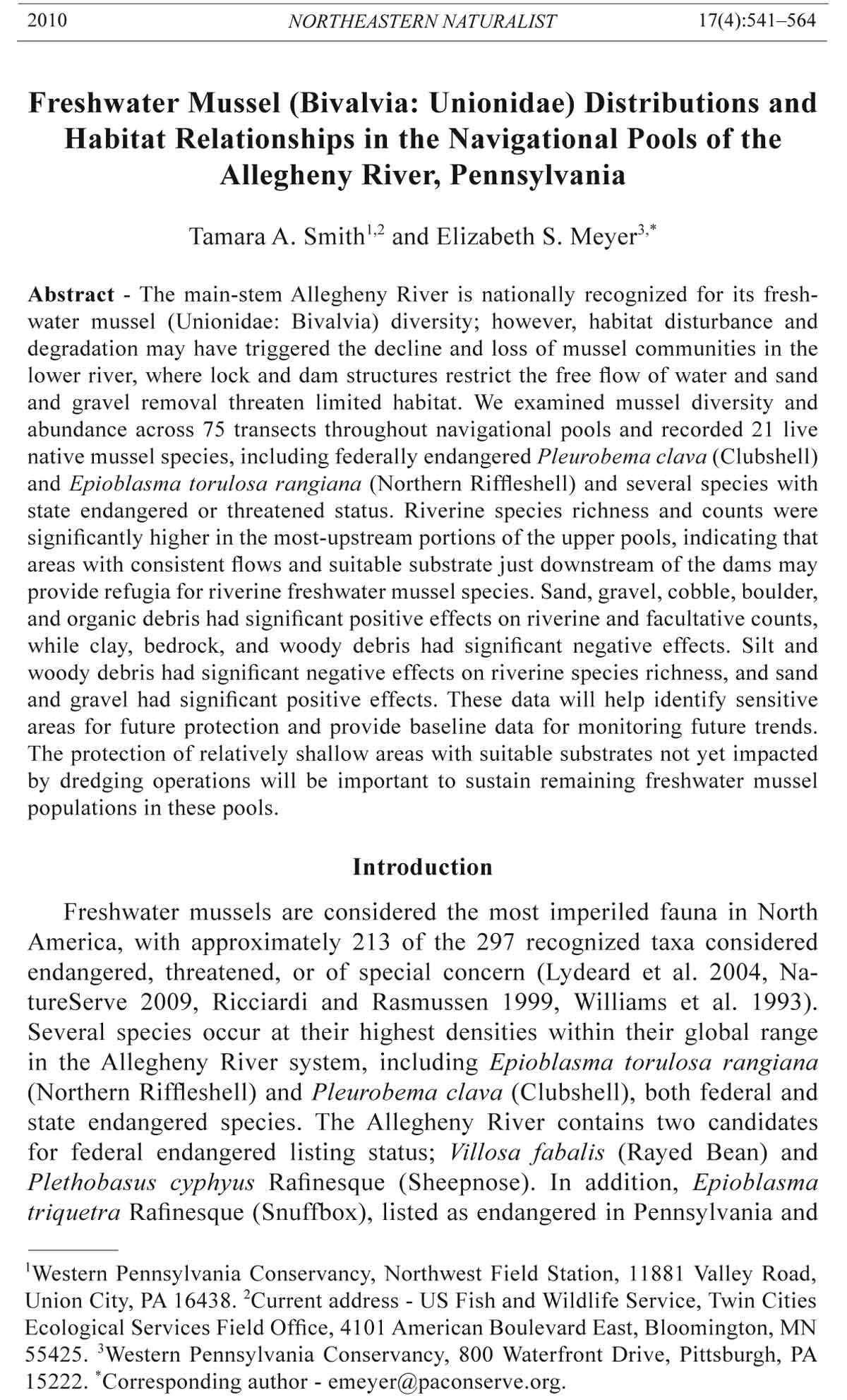
Corps of Engineers 2010b). This study took place in navigational pools 4, 5,
6, 7, and 8 (Fig.1).
Figure 1. Transect locations in the Allegheny River navigational pools 4, 5, 6, 7,
and 8. The insert magnifies a portion of pool 6, where transect locations were dense.
River kilometers are abbreviated as RKM.
544 Northeastern Naturalist Vol. 17, No. 4
Transect selection
Our surveys targeted relatively undisturbed areas believed to be suitable
habitat for mussels. We sampled relatively shallow areas (<15 m
deep). In 2005 and 2006, we determined potential habitat using an Eagle
FishMark 320 depth finder. In 2007, we used newly collected bathymetric
mapping data (Long and Chapman 2008) to determine potential habitat
throughout pools 5 through 8. We selected transects where the channel
had a gradual slope from shore out to mid-channel. Areas with abrupt
changes in depths were suspected to have been recently dredged and were
avoided if possible. Although we attempted to survey at least one transect
per river km, some areas were avoided because of extremely deep water
depths (e.g., portions of pools 5 and 7). Transects are represented by river
km (RKM) as measured upstream from the confluence with the Monongahela
River. Areas with recent surveys (i.e., RKMs 93.7 to 94.3) that used
similar protocols (US Fish and Wildlife Service 2004) were also avoided
to reduce handling disturbance, which can affect growth (Haag and Commens-
Carson 2008).
Survey methodology
We followed protocols developed for the Ohio and Allegheny Rivers
(ORVET 2004) to survey for mussels. Weighted transect lines (100 m by
1 m) were placed perpendicular to river flow. Each transect was divided
into 10-m segments, and each segment was searched for at least 5 minutes
and until all visible mussels were collected. Transect segments were generally
not searched if the substrate was 100% bedrock or had at least 25 cm of
silt deposition, although we did search some segments with thick silt substrate
using less effort (<5 minutes segment). Substrate was characterized
and maximum water depth was recorded for each 10-m segment. The percent
of substrate types, defined by particle sizes in a modified Wentworth
scale (Wentworth 1922), was visually estimated and recorded as percent
area of each substrate type (silt, sand, gravel, cobble, boulder, bedrock,
woody debris, and organic debris). In this study, woody debris was defined
as relatively large pieces of wood (≥15 cm), while organic debris typically
consisted of a mix of relatively small pieces of wood (<15 cm), leaves and
other organic materials.
Mussels within each segment were placed into mesh bags, identified,
counted, and measured to the nearest mm in total length. All mussels were
released via broadcast from the surface along the transect line immediately
following processing, with the exception of federally listed species, which
were placed back in the substrate by hand. All taxonomy followed Turgeon
et al. (1998).
We surveyed by SCUBA in pairs when conditions were safe for diving
and the discharge measured on the Allegheny River at Kittanning, PA (US
Geological Survey stream gage; www.waterdata.usgs.gov) was preferably
2010 T.A. Smith and E.S. Meyer 545
less than 8000 cubic feet per second (cfs). One dive was at 10,400 cfs and
another was at 9130 cfs. The surveys did not follow rain events, and visibility
was always >1 m.
Analyses
Each species found in this survey was assigned to a category based on
accounts of the biology and habitat preferences (Parmalee and Bogan 1998)
combined with observational experience specific to the Allegheny River.
Riverine species were defined as those that tend to live in faster flowing systems
and are less tolerant of silt. Facultative species were defined as species
that tend to live in slower areas of otherwise flowing systems. Facultative
species are silt tolerant to a degree, but tend not to occur in completely lentic
habitats such as deep silt layers. Lentic species were defined as those that
tend to live in non-flowing waters.
We used a generalized linear mixed-effects model to analyze mussel
count data and species richness as a function of environmental variables using
R version 2.10.0 (R Development Core Team 2009). Fixed effects were
maximum depth, distance from the nearest upstream dam, river km (RKM),
and each of the substrate types. We also included maximum depth as a nonlinear
factor (maximum depth squared) in the model. Transect was included
in the model as a random effect, because the variance between transects was
expected to be greater than within-transect (between segment) variance.
We examined correlation between the covariates to ensure that colinearity
would not influence the parameter estimates. To account for overdispersion
(many zeros) in the data, we used a quasi-likelihood Poisson procedure,
which allows the estimation of model parameters without fully knowing the
error distribution of the response variable (McCullagh and Nelder 1989).
Variables were considered significant at P = 0.05 level.
We used logistic regression to analyze presence or absence of the 10
most common mussels (number of individuals >35) as a function of environmental
variables using R version 2.10.0 (R Development Core Team 2009).
Transect was included in the model as a random effect, and fixed effects
were maximum depth, maximum depth squared, distance from the nearest
upstream dam, river km (RKM), and each of the substrate types. Variables
were considered significant at P = 0.05 level.
We used size criteria to examine the number of juvenile mussels
because of the ease and consistency of measuring lengths in the field.
Juveniles were defined as individuals less than or equal to 30 mm in total
length; other studies have used similar size limits (e.g., Chapman and
Smith 2008; Mohler et al. 2006; Obermeyer 1998; Smith and Crabtree, in
press). We used a cut-off of 20 mm for Rayed Bean, which is a naturally
smaller species (Cummings and Mayer 1992). Sex ratios of sexually dimorphic
species were also examined.
The probability of detecting a mussel species relates to the sampling
effort and search efficiency within the sample area, the distribution of
546 Northeastern Naturalist Vol. 17, No. 4
Table 1. Global and Pennsylvania State ranks for each species found during this study, and number of live found in each pool. Species only found as dead specimens
in a particular pool are represented by asterisks. Key to global ranks: G5 = secure, G4 = apparently secure, G3 = vulnerable, G2 = imperiled, G1 = critically
imperiled, T2 = subspecies. Key to state ranks: S5 = secure, S4 = apparently secure, S3 = vulnerable, S2 = imperiled, S1 = critically imperiled, SNR = not ranked.
Ranks according to NatureServe (2009). Northern Riffleshell and Clubshell are listed as federally endangered and the Rayed Bean is a candidate for federal listing.
Each species was categorized as primarily riverine (R), facultative (F), or lentic (L) according to Parmalee and Bogan (1998).
Number live per pool
Species Riverine, facultative, or lentic Global rank PA State rank 4 5 6 7 8
Actinonaias ligamentina (Lamarck) (Mucket) R G5 S5 1 148 611 490 1620
Alasmidonta marginata Say (Elktoe) R G4 S4 2 1 *
Amblema plicata (Say) (Three-ridge) L G5 S2 S3 * *
Elliptio dilatata (Rafinesque) (Spike) R G5 S4 * 114 1139 488 827
Epioblasma torulosa rangiana (Lea) (Northern Riffleshell) R G2 T2 S2 3
Dreissena polymorpha Pallas (Zebra Mussel) Exotic Exotic Exotic 73 2
Fusconaia flava (Rafinesque) (Wabash Pigtoe) F G5 S2 37 27 5 1
Fusconaia subrotunda (I. Lea) (Long-solid) R G3 S1 2 *
Lampsilis cardium Rafinesque (Plain Pocketbook) F G5 S4 * 14 8 13
Lampsilis fasciola Rafinesque (Wavy-rayed Lampmussel) R G5 S4 1
Lampsilis ovata (Say) (Pocketbook) R G5 S3 S4 10 * 25
Lampsilis siliquoidea (Barnes) (Fatmucket) F G5 S4 2 35 121 31 49
Lasmigona costata (Rafinesque) (Fluted-shell) F G5 S4 25 124 91 48
Leptodea fragilis (Rafinesque) (Fragile Papershell) F G5 S2 1 2 26 18 40
Ligumia recta (Lamarck) (Black Sandshell) R G5 S3 S4 1 5 18 10 24
Pleurobema clava (Lamarck) (Clubshell) R G2 S1 S2 1
Pleurobema sintoxia (Rafinesque (Round Pigtoe) R G4 S2 3 1
Potamilus alatus (Say) (Pink Heelsplitter) F G5 S2 10 53 42 7
Potamilus ohiensis (Rafinesque) (Pink Papershell) F G5 SNR *
Ptychobranchus fasciolaris (Rafinesque) (Kidneyshell) R G4 G5 S4 5
Pyganodon grandis (Say) (Giant Floater) L G5 S4 * 1
Simpsonaias ambigua (Say) (Salamander Mussel) F G3 S1 4 2
Strophitus undulatus (Say) (Creeper) F G5 S4 S5 1 3
Villosa fabalis (I. Lea) (Rayed Bean) R G1 G2 S1 S2 1 * 11
Villosa iris (I. Lea) (Rainbow) R G5 S1 *
2010 T.A. Smith and E.S. Meyer 547
sampling effort, and the abundance and spatial distribution of the species
(Smith 2006). An unbiased estimation of abundance or density is only possible
when the fraction of the survey area and the search efficiency is known
or estimated, and in general, search efficiency increases with increasing
search time (Smith 2006). We assumed equal detectability of all species for
our analyses, calculated our overall search rate and survey area as a means
of comparison to other studies, and calculated a mean overall search rate for
our study from the search times we recorded for each 10-m segment. The
fraction of the pools that was searched was calculated as the sum of the areas
of each unit (10-m2 segments) in the entire survey (75 transects) divided by
the total area of pools 4 through 8.
Results
A total of 75 transects were surveyed; six transects were sampled in pool
4, eight in pool 5, 31 in pool 6, 10 in pool 7, and 20 transects in pool 8 (Fig. 1,
Table 1). Our mean search time per 10-m2 segment was 12.5 minutes (SE =
6.32), which gives a mean search rate of 1.25 min/m2. The fraction the total
pool area surveyed was 0.08% (Table 2). Survey depths ranged from 0.5 to
13 m. No live mussels were found >10 m deep; over 95% of all live mussels
were found in <6 m deep.
Overall, we recorded 6403 live native Unionids from 21 species (Table 2).
Sixty-one fresh dead and 2905 weathered dead shells were found, adding
three species that were found only as shells. We also found the invasive exotic
Dreissena polymorpha Pallas (Zebra Mussel) in 4 transects (Table 3).
Table 2. Transect summary data for each pool. The mean, standard error of the mean (SE), minimum,
and maximum number of individuals and number of species found per 100-m transect
are given. Minimum, maximum, and mean maximum depths per 10-m segment in pool are also
given. Numbers do not include Zebra Mussels. The fraction of the survey area was calculated as
the sum of survey areas divided by the total area of pool and is given as a percentage. PL = pool
length (km), PA = pool area (km2), # = number of transects, % = percent area surveyed.
Segment maximum Count per Number of species
depth (m) transect per transect
Mean Mean Mean
Pool PL PA # % Min Max (SE) Min Max (SE) Min Max (SE)
4 9.9 3154 6 0.03 1.8 9.8 4.4 1 5 2.8 1 3 1.8
(0.25) (0.60) (0.31)
5 9.5 2663 8 0.06 1.7 9.1 4.3 2 208 62.4 1 8 5.5
(0.18) (23.91) (0.78)
6 15.1 4910 31 0.12 0.5 7.9 3.5 1 262 69.3 1 10 6.2
(0.09) (11.73) (0.44)
7 11.1 3093 10 0.05 0.6 12.5 3.8 0 463 115.0 0 10 5.1
(0.34) (174.08) (1.18)
8 15.5 3954 20 0.09 1.2 13.1 4.0 0 492 133.3 0 10 4.2
(0.14) (39.65) (0.94)
548 Northeastern Naturalist Vol. 17, No. 4
Table 3. Summary data for each species found in our surveys including total numbers (count) and number of transects in which we found the species (transects
occupied out of 75). Minimum, maximum, and mean total length with standard error (SE) mean total length is given. Sex of all individuals, number of juvenile
mussels, and number of transects with juveniles is also given (sex and size data may be biased since we assumed equal detectability for all species).
Length of all individuals (mm) Sex of all individuals Juveniles
Species Count Transects occupied Min Max Mean (SE) F M Unknown Count Transects occupied
Actinonaias ligamentina 2870 47 43.0 163.0 112.5 (0.65) 0 0 2870 0 0
Alasmidonta marginata 3 3 60.0 66.4 63.8 (1.94) 0 0 3 0 0
Elliptio dilatata 2568 53 13.0 144.0 104.0 (0.43) 0 0 2568 5 5
Epioblasma torulosa rangiana 3 2 42.0 48.0 44.7 (2.19) 2 1 0 0 0
Dreissena polymorpha 74 4 9.0 31.0 10.4 (0.36) 0 0 74 NA NA
Fusconaia flava 70 24 30.0 30.0 71.1 (2.57) 0 0 70 1 1
F. subrotunda 2 1 53.2 60.3 NA 0 0 2 0 0
Lampsilis cardium 35 20 90.0 145.0 119.0 (3.30) 7 17 11 0 0
L. fasciola 1 1 86.0 86.0 NA 0 1 0 0 0
L. ovata 35 12 82.0 151.0 117.2 (3.49) 8 25 2 0 0
L. siliquoidea 238 49 8.0 158.0 113.2 (1.40) 54 97 87 1 1
Lasmigona costata 288 50 36.0 144.0 111.5 (0.90) 0 0 288 0 0
Leptodea fragilis 87 30 34.0 119.0 73.9 (2.43) 0 0 87 0 0
Ligumia recta 58 28 93.9 185.0 135.2 (3.18) 12 34 10 0 0
Pleurobema clava 1 1 31.9 31.9 NA 0 0 1 0 0
P. sintoxia 4 4 72.0 106.0 91.8 (7.35) 0 0 4 0 0
Potamilus alatus 112 36 49.0 181.0 116.0 (2.96) 0 0 112 0 0
Ptychobranchus fasciolaris 5 4 100.0 117.0 110.3 (3.61) 0 0 5 0 0
Pyganodon grandis 1 1 103.0 103.0 NA 0 0 1 0 0
Simpsonaias ambigua 6 2 31.0 44.0 36.0 (1.77) 0 0 6 0 0
Strophitus undulatus 4 4 43.0 76.0 56.5 (7.15) 0 0 4 0 0
Villosa fabalis 12 8 14.0 30.0 20.2 (1.50) 4 7 1 7 4
2010 T.A. Smith and E.S. Meyer 549
Thirteen out of 24 species were classified as vulnerable, imperiled, or critically
imperiled at a global or state level, including the federally endangered
Northern Riffleshell and Clubshell (Table 1). Thirteen species were classified
as riverine, 9 as facultative, and 2 as primarily lentic species (Table 1). We
found 14 total juveniles from four species: Elliptio dilatata (Spike), Fusconaia
flava (Wabash Pigtoe), Lampsilis siliquoidea (Fatmucket), and Rayed
Bean (Table 3). Both sexes were represented for each sexually dimorphic
species, and in general, more males were found than females (Table 3).
Species composition varied among pools. The most ubiquitous species
were Actinonaias ligamentina (Mucket) and Spike, which were present
in every pool (Table 1) and were the dominant species in pools 5 through
8. Mucket was found at 47 transects and accounted for about 44.3% of
the total number of mussels found, while Spike was found at 53 transects
and accounted for about 39.7% of the total number of mussels found
(Table 3). Other species found at a relatively large number of transects but
at low relative abundance were Lasmigona costata (Fluted Shell) (4.5%, 50
transects), and Fatmucket (3.7%, 49 transects), Leptodea fragilis (Fragile
Papershell) (1.3%, 30 transects), Ligumia recta (Black Sandshell) (0.9%,
28 transects), and Wabash Pigtoe (1.1%, 24 transects). Potamilus alatus
(Pink Heelsplitter) (1.7%, 36 transects) was the dominant species found
in pool 4 and was the third-most abundant species in pool 5. Species
with the most limited distributions were Northern Riffleshell, Fusconaia
subrotunda (Long-solid), Lampsilis fasciola (Wavy-rayed Lampmussel),
Pyganodon grandis (Giant Floater), Clubshell, and Ptychobranchus fasciolaris
(Kidneyshell) (Table 3).
Individual pool results
Pool 4. Only six species were found, and total counts were generally low
in pool 4 (Tables 1 and 2). Pink Heelsplitter accounted for 10 of the 17 live
individuals found. Spike, Giant Floater, and Potamilus ohiensis (Pink Papershell)
were found only as dead shells. Nearly half of the surveyed segments
were comprised of over 50% silt substrate.
Pool 5. Counts were low in pool 5 (Tables 1 and 2) except at the uppermost
transects. Richness ranged from 1 to 8 per transect, with 10 species
found throughout the pool. Substrate composition was generally a mix of
cobble and gravel, with some silt.
Mucket and Spike were the dominant species in the three transects in the
upper pool (RKM 56.9, 57.3, and 57.4), where over 78% of the Unionids in
this pool were found. Wabash Pigtoe and Pink Heelsplitter were dominant
in transects surveyed in the lower portions of the pool between RKMs 50
to 54. Simpsonaias ambigua (Salamander Mussel) was found only as 4 live
individuals in the lower pool, under large flat rocks in a transect that was
dominated by gravel with a maximum depth of 2.3 m. Lampsilis cardium
(Plain Pocketbook) was found only as weathered shells. We found 73 live
Zebra Mussels; 72 were in one transect (RKM 52.9), and most were <10 mm
in total length and attached to Unionids.
550 Northeastern Naturalist Vol. 17, No. 4
Pool 6. In pool 6, counts were high, and species richness was the highest
(Tables 1 and 2). We found 17 live species throughout the pool, which
is the most species we recorded in any of the pools. Substrate composition
was generally a mix of sand, gravel, cobble, and boulder, except in a few
transects that were dominated by silt (i.e., RKM 59.5, 59.9, and 64.2).
Rayed Bean was found live in one transect in the upper pool, and Salamander
Mussel was found live under a large flat rock in another transect in
the upper half of the pool. In addition, one dead Villosa iris (Rainbow) was
encountered. We found two juvenile Spikes between RKMs 71 and 73 and
one juvenile Wabash Pigtoe near RKM 63. We found two live and two dead
Zebra Mussels in pool 6.
Pool 7. Counts were generally low in Pool 7 (Tables 1 and 2); however,
it is the only pool in which we documented Three-ridge in our study, which
was found as a weathered dead shell. No surveys occurred in the lower portions
of pool 7 due to extreme water depths.
Three transects surveyed below a railroad bridge, an area restricted from
dredging operations, were unlike the other 7 transects surveyed in pool 7. In
these transects, we documented 8 to 10 live species and 289 to 463 live individuals
per transect. The substrate was comprised mainly of sand, gravel,
cobble, and boulder substrates, and maximum depths ranged from 0.6 to
4.0 m. In this section of intact habitat below the railroad bridge, we found
live Clubshell and the only juvenile mussel (Spike) in this pool. Outside
of those areas, total abundances ranged from 0 to 29 live individuals per
transect (mean total abundance = 10.4, SE = 4.15), with 0 to 7 live species
per transect (mean species richness = 3.3, SE = 1.04). Substrate in these
transects was dominated by silt and boulders, and maximum depths per segment
ranged from 2.4 to 12.5 m. Mean maximum depth per 10-m segment in
the three transects below the railroad bridge was 2.06 m (SE = 0.156), and
mean maximum depth in all other transects was 5.33 m (SE = 0.482).
Pool 8. Maximum depths per 10-m segment in pool 8 ranged from 1.2
to 13.1 m, with a mean maximum depth of 3.96 m (SE = 0.138, Table 2).
Mean depth per 10-m segment was 3.58 m (SE = 0.098) in the upper portion
of the pool (RKM 94.6 to 98.6) and 4.29 m (SE = 0.250) downstream
of RKM 91.9.
Species richness and abundances above RKM 94.6 in pool 8 were unlike
segments surveyed downstream of RKM 91.9. No transects were surveyed
between RKM 91.9 and 94.6 in this study. Surveyed transects between RKM
94.6 and 98.6 had total counts ranging from 222 to 492 live individuals
(mean total abundance = 329.6, SE = 38.52), with 6 to10 live species (mean
species richness = 8.9, SE = 0.52). These transects in the upper portion of the
pool generally had a mixture of sand, gravel, cobble, and boulder substrate
with maximum depths less than 4.9 m. Live Northern Riffleshell was found
in two transects in the upper portion of pool 8 in segments with a mixture
of sand, gravel, cobble, and boulder substrate and at maximum depths of
approximately 3.5 m. Transects that contained live Northern Riffleshell had
2010 T.A. Smith and E.S. Meyer 551
relatively high species richness (10 species) and total counts (358 and 483).
Rayed Bean was found live at several locations in the upper portion of pool
8, and we also documented Wavy-rayed Lampmussel in the upper part of the
pool. In addition, one dead Alasmidonta marginata (Elktoe) was found. We
found 10 juvenile mussels in the upper portion of pool 8: seven Rayed Bean,
one Fatmucket, and two Spikes. Transects surveyed below RKM 91.9 in
pool 8 had total abundances ranging from 0 to12 live individuals (mean total
abundance = 2.3, SE = 1.06) and 0 to 4 species (mean species richness = 1.0,
SE = 0.39). Transects in the lower portion of the pool had generally deeper
segments and high percentages of silt. No juvenile mussels were found at
these downstream transects.
In-stream habitat relationships
The relationships between counts and richness to maximum depth are
not linear. The results of the mixed effects analyses show that maximum
depth had significant positive effects on total counts and richness (Table 4),
riverine species counts and richness (Table 5), and facultative species counts
and richness (Table 6). Conversely, maximum depth squared shows signifi-
cant negative effects on total, riverine, and facultative counts and species
richness (Tables 4, 5, and 6). These analyses show the significance of the
patterns observed: low counts and richness at low depths, their peak at intermediate
depths (approximately 4 m), and subsequent decline to zero at the
highest maximum depths (Fig. 2).
Table 4. Results of the generalized linear mixed-effects model (656 observations, 74 groups).
Response variables were total mussel counts and total species richness. The estimate, standard
error (SE), and t-value is given for each fixed effect. Variance and standard deviation (std. dev.)
are given for each random effect. Environmental variables were considered significant at P <
0.05 level (shown in bold).
Total count Species richness
Fixed effects Estimate SE t-value Estimate SE t-value
Intercept -0.642 0.214 -3.000 -6.03E-01 2.41E-01 -2.505
Clay -0.003 0.001 -2.370 7.05E-03 3.04E-03 2.317
Silt 0.000 0.001 -0.740 -2.77E-05 1.33E-03 -0.021
Sand 0.001 0.000 1.150 2.67E-03 1.37E-03 1.952
Gravel 0.002 0.000 3.890 4.18E-03 1.35E-03 3.106
Cobble 0.001 0.000 2.870 2.00E-03 1.22E-03 1.640
Boulder 0.002 0.000 4.190 2.50E-03 1.42E-03 1.756
Bedrock -0.022 0.001 -21.370 -6.10E-03 2.43E-03 -2.508
Organics 0.069 0.004 19.090 3.50E-02 6.71E-03 5.215
Woody debris -0.022 0.001 -28.360 -1.07E-02 2.62E-03 -4.068
Max. depth 0.831 0.016 52.690 5.30E-01 4.17E-02 12.691
Max. depth2 -0.099 0.002 -45.170 -6.51E-02 4.98E-03 -13.057
RKM 0.028 0.003 10.540 1.22E-02 2.39E-03 5.086
Distance dam -0.371 0.011 -33.940 -2.22E-01 1.05E-02 -21.145
Random effects Variance Std. dev. Variance Std. dev.
Transect 0.107 0.327 0.072 0.267
Residual 0.051 0.226 0.133 0.364
552 Northeastern Naturalist Vol. 17, No. 4
Table 5. Results of the generalized linear mixed-effects model (656 observations, 74 groups).
Response variables were total riverine mussel counts and total riverine species richness. The
estimate, standard error (SE), and t-value is given for each fixed effect. Variance and standard
deviation (Std. Dev.) are given for each random effect. Environmental variables were considered
significant at P < 0.05 level (shown in bold).
Riverine total count Riverine species richness
Fixed effects Estimate SE t-value Estimate SE t-value
Intercept -2.695 0.141 -19.170 -1.783 0.173 -10.326
Clay -0.070 0.004 -19.820 -0.011 0.005 -2.199
Silt 0.002 0.000 5.190 -0.005 0.001 -4.426
Sand 0.002 0.000 7.310 0.004 0.001 4.045
Gravel 0.004 0.000 12.440 0.007 0.001 6.410
Cobble 0.002 0.000 9.010 0.003 0.001 2.657
Boulder 0.004 0.000 12.830 0.005 0.001 4.232
Bedrock -0.022 0.001 -35.640 -0.003 0.002 -1.637
Organics 0.057 0.003 20.310 -0.011 0.009 -1.214
Woody debris -0.021 0.000 -46.820 -0.009 0.002 -4.030
Maximum depth 0.827 0.010 82.600 0.419 0.035 12.103
Maximum depth2 -0.101 0.001 -69.790 -0.056 0.004 -13.370
RKM 0.052 0.002 30.040 0.022 0.002 14.486
Distance dam -0.449 0.007 -59.950 -0.198 0.007 -28.250
Random effects Variance Std. dev. Variance Std. dev.
Transect 0.042 0.206 0.022 0.148
Residual 0.015 0.122 0.056 0.237
Table 6. Results of the generalized linear mixed-effects model (656 observations, 74 groups).
Response variables were total facultative mussel counts and total facultative species richness.
The estimate, standard error (SE), and t-value is given for each fixed effect. Variance and
standard deviation (Std. Dev.) are given for each random effect. Environmental variables were
considered significant at P < 0.05 level level (shown in bold).
Facultative total count Facultative species richness
Fixed effects Estimate SE t-value Estimate SE t-value
Intercept -2.695 0.141 -19.170 -0.808 0.254 -3.179
Clay -0.070 0.004 -19.820 0.011 0.004 3.165
Silt 0.002 0.000 5.190 0.001 0.002 0.347
Sand 0.002 0.000 7.310 0.004 0.002 2.137
Gravel 0.004 0.000 12.440 0.003 0.002 1.961
Cobble 0.002 0.000 9.010 0.003 0.001 2.262
Boulder 0.004 0.000 12.830 0.001 0.002 0.395
Bedrock -0.022 0.001 -35.640 -0.007 0.004 -1.680
Organics 0.057 0.003 20.310 0.034 0.007 5.175
Woody debris -0.021 0.000 -46.820 -0.007 0.004 -1.991
Maximum depth 0.827 0.010 82.600 0.424 0.053 7.945
Maximum depth2 -0.101 0.001 -69.790 -0.056 0.006 -8.85
RKM 0.052 0.002 30.040 0.004 0.002 1.808
Distance dam -0.449 0.007 -59.950 -0.172 0.010 -17.163
Random effects Variance Std. dev. Variance Std. dev.
Transect 0.042 0.206 0.046 0.214
Residual 0.015 0.122 0.125 0.354
2010 T.A. Smith and E.S. Meyer 553
Distance from the nearest upstream dam had significant negative effects
on total counts and total species richness, as well as riverine and facultative
counts and richness (Tables 4–6, Fig. 2). River kilometer (RKM) had
significant positive effects on total, riverine, and facultative species richness
and counts (Tables 4–6, Fig. 2), meaning that segments in the upper
pools (higher RKM) had relatively high counts and species richness. Gravel,
boulder, and organic debris had significant positive effects on total species
richness and total counts (Table 4). Cobble had significant positive effects
on total counts, while clay, bedrock, and woody debris had significant negative
effects (Table 4). Sand and clay had significant positive effects on total
species richness, while bedrock and woody debris had significant negative
effects (Table 4). Sand, gravel, cobble, boulder, organic debris, and silt had
significant positive effects on riverine and facultative counts, while clay,
Figure 2. Scatterplot matrix of total riverine and facultative species counts (River.
Count and Fac.Count, respectively) and riverine and facultative species richness
(River.SPP and Fac.SPP, respectively) and maximum depth (m; Max.Depth), distance
(km) from the nearest upstream dam (Dist.Dam), and river km (RKM) per
10-m segment.
554 Northeastern Naturalist Vol. 17, No. 4
bedrock, and woody debris had significant negative effects (Tables 5 and 6).
Silt, clay, and woody debris had significant negative effects on riverine species
richness and sand, gravel, cobble, and boulder had significant positive
effects (Table 5). Clay, sand, gravel, cobble, and organic debris had signifi-
cant positive effects on facultative species richness, while woody debris had
significant negative effects (Table 6).
Results from the logistic regression analyses on presence-absence data
show that distance from nearest upstream dam had significant negative
effects and RKM had significant positive effects on Mucket, Spike, Fatmucket,
Fragile Papershell, Black Sandshell, Lampsilis ovata (Pocketbook),
and Plain Pocketbook presence (Table 7). River km (RKM) had significant
negative effects on Wabash Pigtoe and Pink Heelsplitter presence (Table 7).
Maximum depth had significant positive effects on Mucket (Est. = 1.211, SE
= 0.528, Z value = 2.294, Pr(>|z|) = 0.022) and Spike (Est. = 2.149, SE =
0.539, Z value = 3.990, Pr(>|z|) = 0.000) and Fragile Papershell (Est. = 1.121,
SE = 0.570, Z value = 1.967, Pr(>|z|) = 0.049). Maximum depth squared had
significant negative effects on Mucket (Est. = -0.142, SE = 0.061, Z value
= -2.335, Pr(>|z|) = 0.020), Spike (Est. = -0.225, SE = 0.059, Z value =
-3.838, Pr(>|z|) = 0.000), and Fatmucket (Est. = -0.102, SE = 0.049, Z value
= -2.091, Pr(>|z|) = 0.037). These results indicate a nonlinear relationship
between maximum depth and Mucket, Spike, and Fatmucket. In other words,
after an intermediate depth (approximately 4 m), the presence of these three
species declines. Silt had significant negative effects on Pocketbook (Est. =
-0.074, SE = 0.037, Z value = -1.988, Pr(>|z|) = 0.047) and Plain Pocketbook
(Est. = -0.040, SE = 0.020, Z value = 2.011, Pr(>|z|) = 0.044) presence. Sand
(Est. = 0.041, SE = 0.016, Z value = 2.513, Pr(>|z|) = 0.012) and gravel (Est.
= 0.032, SE = 0.015, Z value = 2.097, Pr(>|z|) = 0.036) had significant positive
effects on Mucket presence. All other environmental variables were not
statistically significant.
Table 7. Results of the logistic regression (656 observations, 74 groups) on the presence or
absence of the 10 most common species (number of individuals > 35). Environmental variables
were considered significant at P < 0.05 level; fixed effects not presented in this table or in the
text were not significant. Distance from nearest upstream dam was not significant for F. flava
(Wabash Pigtoe) and river kilometer (RKM) was not significant for L. costata (Flutedshell).
Distance from nearest upstream dam RKM
Est. SE Z value Pr(>|z|) Est. SE Z value Pr(>|z|)
A. ligamentina -0.612 0.116 -5.281 0.000 0.079 0.025 3.146 0.002
E. dilatata -0.675 0.118 -5.723 0.000 0.096 0.028 3.457 0.001
F. flava -0.061 0.082 -0.745 0.456 -0.058 0.021 -2.745 0.006
L. cardium -0.221 0.097 -2.276 0.023 0.031 0.015 2.061 0.039
L. ovata -0.362 0.175 -2.061 0.039 0.101 0.025 3.993 0.000
L. siliquoidea -0.211 0.051 -4.125 0.000 0.021 0.011 1.940 0.052
L. costata -0.215 0.059 -3.640 0.000 0.026 0.014 1.923 0.054
L. fragilis -0.166 0.064 -2.615 0.009 0.055 0.015 3.665 0.000
L. recta -0.262 0.080 -3.260 0.001 0.039 0.013 3.022 0.003
P. alatus -0.227 0.065 -3.474 0.001 -0.059 0.013 -4.447 0.000
2010 T.A. Smith and E.S. Meyer 555
Discussion
The Pittsburgh District of the US Army Corps of Engineers operates
eight locks and dams on the Allegheny River for navigation of commercial
vessels. Dams fragment mussel habitat by inhibiting longitudinal
movement of host fishes and glochidia (Watters 1996). Furthermore, the
impoundments provide habitat for invasive species such as Zebra Mussels,
which are a documented threat to freshwater mussels (Biggins et al. 1995,
Ricciardi et al. 1998, Strayer and Malcom 2007) and were present in this
study. The detrimental effects of dams and impoundments on freshwater
ecosystems has been widely documented (e.g., Bates 1962; Baxter 1977;
Blalock and Sickel 1996; Bogan 1993; Chessman et al. 1987; Kondolf
1997; Parmalee and Hughes 1993; Porto et al 1999; Richter et al. 1997;
Sickel et al. 2007; Vaughn and Taylor 1999; Watters 1996; 2000; Williams
and Fuller 1992).
The lock-and-dam structures on the Allegheny River have altered the river
from free-flowing, well-oxygenated riffles and runs into a series of deep,
slower-flowing pools or lakes (Ortmann 1909). Of the entire 22.6 million-m2
mapped area in pools 4 through 8, 37.1% is deeper than 6 m and 19.5% is
deeper than 9 m (E. Long, Western Pennsylvania Conservancy, Blairsville,
PA., pers. comm.; Long and Chapman 2008). Of the surveyed segments,
10.2% were in areas deeper than 6 m and 2.1% were in areas deeper than
9 m. The results of our study show that 95% of the live individuals were
found in the relatively shallow areas (less than 6 m) of these pools, and zero live
individuals were found in the fourteen segments surveyed in areas deeper
than 9 m. Generally, shallow depths are productive biologically due to solar
penetration, dynamic currents, and higher dissolved-oxygen levels (Allan
1995, Vannote et al. 1980). However, there have been mussels documented
from other systems in water deeper than 9 m (e.g., James 1985, Reigle 1967)
where bottom water flow was adequate and the substrate composition was
favorable. Therefore, although depth may provide us with some indication
where mussels persist in the Allegheny River, depth should not be used as the
only indicator of mussel presence in a system. Habitat parameters combine
to create suitable habitat for mussel populations (Parmalee and Bogan 1998,
Strayer 2008).
Longitudinal shifts in community composition and abundance occur
naturally in river systems (Vannote et al. 1980), and we observed a change
from an abundance of facultative species more typical of slow-moving rivers
in the lower pools to a dominance of riverine species in the upper pools.
Pink Heelsplitter, for example, the dominant species in pool 4, gradually
decreased in relative abundance going upstream and was not present in our
surveys in pool 8. In contrast, the upper pools were dominated by Mucket
and Spike and contained species more typical to smaller waterways, such as
Elktoe and Wavy-rayed Lampmussel. In addition to the shift from riverine
to facultative species throughout the navigational pools of the Allegheny
River as it flows towards its confluence, we documented similar changes
556 Northeastern Naturalist Vol. 17, No. 4
within each pool. Riverine species richness and counts were higher in the
upper portions of the pools, indicating that areas with consistent flows and
suitable substrate just downstream of the dams may provide refugia for riverine
freshwater mussel species.
In the Allegheny River navigational pools, impoundments are confounded
with river bottom disturbance. Sand and gravel extraction can
significantly alter the chemical, physical, and biological components of
mined streams and rivers (e.g., Brown et al. 1998, Meador and Layher
1998, Nelson 1993). Altered substrate and flow resulting from gravel extraction
can reduce or eliminate mussel populations (Hubbs et al. 2003).
Dredging removes sand and gravel substrate, and the deep depressions
that remain often fill with silt and debris (Brown et al. 1998) unsuitable
for colonization by riverine mussels. These deep portions of the river
may not be subjected to any water currents and therefore have depleted
dissolved-oxygen levels. Recent studies show significantly higher levels of
total dissolved solids, turbidity, arsenic, selenium, and zinc in river water
following mining operations in the Allegheny River (Murray et al. 2008).
Additionally, river islands and shoals, which provide important habitat
for mussels, are also affected by dredging due to increased erosion from
altered flow regimes in close proximity to islands (Kondolf 1997). In addition
to the direct effects to mussels, suspended sediments from excavation
activities have led to the loss or reduction of fish and macroinvertebrate
spawning, rearing, and foraging habitat (Brown et al. 1998), which means
the potential loss of the fish hosts needed to complete freshwater mussel
lifecycles. It can take decades for a river to recover from sand and gravel
mining without remediation (e.g., Kanehl and Lyons 1992). It is not known
how much time is needed to replenish substrate in a system where the
natural migration of gravel and sand from upstream sources is impeded by
impoundments, such as in the lower Allegheny River.
This study provides some evidence that the alteration and loss of habitat
due to sand and gravel dredging activities has had an adverse effect on the
freshwater mussel fauna of the Allegheny River navigational pools. The upper
portion of pool 8, which has not been mined, had consistently high counts
and species richness, evidence of recruitment, and an undisturbed habitat
comprised of a mix of sand, gravel, cobble, and boulders. Conversely, total
counts and richness in pool 8 were low in areas with past or current commercial
mining permits (in the lower half of the pool). In these areas, maximum
depths were generally deeper than in non-dredged areas, and silt dominated
the substrate composition. Similarly, only in the protected area of pool 7 did
we find an abundant and diverse mussel community. Much of pool 7 is highly
impacted by commercial sand and gravel dredging, resulting in relatively
deep water up to 14 m (Long and Chapman 2008). Divers observed a high
percentage of silt in these areas; thick silt substrate is unsuitable for most
riverine mussels. Relatively shallow depths indicate undisturbed substrate in
this pool; for example, since no dredging is allowed within 500 feet of any
2010 T.A. Smith and E.S. Meyer 557
bridge, pier, or abutment (US Army Corps of Engineers 2007), the substrate
was intact and unaltered under the railroad bridge and, subsequently, the species
richness and counts were higher there than those observed in the deeper,
dredged areas.
Pool 6 has a moratorium on dredging operations that has been in place
since December of 1985, which may account for the relatively high abundances
and species diversity recorded there. However, this type of restriction
may not be feasible for resource managers who are faced with the challenge
of protecting imperiled species while not impeding commercial operations.
Depth-limited dredging restrictions or limitations to areas that have been
previously altered may be one option to allow commercial mining in areas
where it has already occurred while still protecting remaining mussel habitat.
The protection of any relatively shallow areas with intact substrate will
be important to sustain any remaining freshwater mussel populations in
these pools.
Of the 65 species of freshwater mussels that have been reported from
Pennsylvania, at least 11 (17%) have not be collected in the past 25 years
and are considered historic or possibly extirpated (PNHP 2009). The range
of all 11 of those species included the currently pooled sections of both the
Allegheny and Ohio River mainstems. Nationally, over the past 100 years,
over 30 species are considered to have gone extinct, with at least 70 others
in danger of extinction (Lydeard et al. 2004, Ricciardi and Rasmussen 1999,
Williams et al. 1993).
Species such as Clubshell and Northern Riffleshell are critically imperiled
throughout most of their range (NatureServe 2009), but exhibit the
highest densities in their range in the middle portion of the Allegheny River
(Villella and Nelson 2006). Clubshell is a species that formerly occupied the
Monongahela River tributaries, Ohio River tributaries, the Allegheny River,
and several tributaries of the Allegheny River in Pennsylvania (Ortmann
1919, USFWS 1994). Clubshell are currently only known from the Shenango
River (Bursey 1987), the French Creek Watershed (Smith and Crabtree, in
press), the middle Allegheny River upstream of our study sites (Villella and
Nelson 2006), and from one live individual found in the upper portion of
pool 8 (USFWS 2004). In Pennsylvania, Northern Riffleshell was historically
known from the Allegheny River, Leboeuf Creek, Conewango Creek,
French Creek, and the Shenango River, (Ortmann 1919, USFWS 1994);
it is currently only known from French Creek (Crabtree and Smith 2009;
Mohler et al. 2006; Smith and Crabtree, in press), Conewango Creek (Evans
and Smith 2005), and the Allegheny River (Villella and Nelson 2006). In
this study, these two species were found only in areas with intact substrate
and relatively high species richness and counts. This result indicates that
there are positive species interactions occurring in those areas. Rare species
in particular have been documented to profit energetically from living
in species-rich communities (Vaughn et al. 2008). Although the relatively
large number of transects surveyed within pool 6 increased our probability
558 Northeastern Naturalist Vol. 17, No. 4
of detecting rare species there, Northern Riffleshell was not found in pool
6 during our surveys. There is some evidence that Northern Riffleshell may
exist in pool 6; it was recently found as a dead specimen along the shore
below lock 7 (PNHP files 1985, 1995a, 1995b, 2002). Much of the habitat
we observed in pool 6 seemed suitable for this species, and in combination
with habitat protection and augmentation, it may be possible for this species
to successfully re-establish in this pool.
The documentation of live Salamander Mussel is particularly important
in Pennsylvania, as it was historically known from the Middle Allegheny-
Redbank drainage (Clarke 1985), but may be extant in the French Creek and
Lower Monongahela River drainages (PNHP 1995b; Smith and Crabtree, in
press). This species is easy to overlook because it is a small-sized mussel and
typically found under large flat rocks, presumably where it was deposited
by its primary host, Necturus maculosus Rafinesque (Mudpuppy) (Parmalee
and Bogan 1998). Early surveys in streams and rivers in western Pennsylvania
were devoid of this species (Ortmann 1909), and the first documented
occurrence in the Allegheny River was in 1969 (Bogan and Locy 2009). It
has since been collected in just a few locations in the Allegheny River navigational
pools (Bogan and Locy 2009).
Several species we expected to see in our surveys were absent, although
they have been recently found both upstream and downstream of the pools
surveyed in this study. Although Sheepnose, a candidate for federal listing,
was absent from our surveys, the middle Allegheny River is considered
a stronghold for this species (Villella et al. 2008) and it is present in the
Ohio River (Zeto et al. 1987). Other species absent from our study that
have been documented in the Allegheny River upstream of our study are
Utterbackia imbecillis Say (Paper Pondshell) and Quadrula cylindrica Say
(Rabbitsfoot) (Villella and Nelson 2006). The low densities typical of these
species in nearby streams (i.e., Mohler et al. 2006; Smith and Crabtree,
in press) indicate that more effort may have been needed to detect those
species to determine their presence in these pools. Three-ridge and Kidneyshell,
which we found but in low numbers, are present in great numbers
in upstream tributaries (i.e., Chapman and Smith 2008; Smith and Crabtree,
in press; Smith and Horn 2006). These two species are known from
small streams to big rivers in a variety of habitats (Parmalee and Bogan
1998), so it is unclear why they are were not more common in our study.
Until this study, Pink Papershell was previously documented only once in
the Allegheny River, and to our knowledge this is the second time it has
been recorded in Pennsylvania (PNHP 2002). Pink Papershell has not been
documented upstream (Villella and Nelson 2006), but is present in the Ohio
River drainage in Ohio (Watters 1995) and West Virginia (Zeto et al. 1987)
and is typically found in slow-moving water (Parmalee and Bogan 1998).
Although the ORVET protocol we used is a useful way to get an initial
look at species presence and rough estimates of relative abundances, it is not
2010 T.A. Smith and E.S. Meyer 559
adequate for finding all rare species that may be present (ORVET 2004). Our
mean search rate of only 1.25 min/m2 was less than the surface search rate
that Smith et al. (2001) determined was necessary to detect Clubshell 31%
of the time and Mucket 70% of the time in surveys upstream of the navigational
pools. Increasing search time and search area would have increased
detectability of species in this study (Smith 2006). We recommend that any
further studies, particularly in areas of proposed projects, use enough effort
to detect rare species (e.g., Smith 2006) and incorporate quadrat-based studies
to get unbiased estimates of species densities, sex ratios, and the number
of juveniles present (Strayer and Smith 2003). More precise and quantitative
measurements of environmental variables could be made at the quadrat
level; however, there has not been much evidence that fine-scale habitat
preferences exist. Other environmental variables, such as water flow and
oxygen levels, may be more important to measure and monitor, for example,
in areas with known reproducing populations.
Understanding spatial and temporal dynamics of mussel populations will
help us understand the benefits of any conservation efforts, comprehend the
consequences of disturbance, and determine if existing regulations are sufficient to protect the mussel communities. We hope the data presented in this
study will provide baselines for future monitoring and conservation efforts.
Relatively intact areas with reproducing populations, for example, could be
monitored and compared to other areas of the river that are being considered
for relocation, introduction, or habitat-restoration efforts.
Acknowledgments
This study was funded by a US Fish and Wildlife Service State Wildlife Grants
Program Grant T-2 administered through the Pennsylvania Fish and Boat Commission
(PAFBC). Supplemental funding from the United States Fish and Wildlife
Service (USFWS) Pennsylvania Field office was used to conduct field work in
2005. Thanks to Patricia Morrison (USFWS), Janet Butler (USFWS), and Robert
Anderson (USFWS) for oversight and dive training. We thank the PA Fish and Boat
Commission (PAFBC) for use of their dive boat and Robert Morgan (PAFBC) and
Doug Fischer (PAFBC) for help with boat operations in 2005. A portion of the 2007
surveys were subcontracted to Environmental Science, Inc. Thanks to the Colcom
Foundation for funding the purchase of a research vessel and thanks to Eric Chapman
(Western Pennsylvania Conservancy [WPC]) for maintaining the boat. We thank the
US Army Corps of Engineers for allowing us lockage and the Rosston Eddy Marina
and Nautical Mile Marina for accommodations and boat repair. Thanks to Scott’s
SCUBA in Freeport, PA and to Divers World in Erie, PA for being accommodating
with special equipment rental and maintenance needs. Thanks to Darran Crabtree
(The Nature Conservancy), Mary Walsh (Pennsylvania Natural Heritage Program
[PNHP]), Jeremy Deeds (PNHP) and Nevin Welte (PAFBC) for reviewing drafts
of this manuscript and to Charles Bier and Erin Stacy (PNHP) for additional help.
This manuscript was substantially improved thanks to the comments of David Smith
(USGS), Beth Gardner (USGS) and two anonymous reviewers. Special thanks to additional
WPC/PNHP SCUBA dive crew members Ryan Evans, Zachary Horn, Nicole
Rhodes, Mary Walsh, Erik Weber, and Jacob Winkler.
560 Northeastern Naturalist Vol. 17, No. 4
Literature Cited
Allan, D.J. 1995. Stream Ecology: Structure and Function of Running Waters. Kleuwer
Academic Publishers, Springer, Norwell, MA. 388 pp.
Bates, J.M. 1962. The impact of impoundment on the mussel fauna of Kentucky
Reservoir, Tennessee River. American Midland Naturalist 68:232–236.
Baxter, R.M. 1977. Environmental effects of dams and impoundments. Annual Review
in Ecological Systems 8:255–283.
Biggins, R.G., R.J. Neves, and C.K. Dohner. 1995. Draft national strategy for the
conservation of native freshwater mussels. US Fish and Wildlife Service, Washington,
DC. 26 pp.
Blalock, H.N., and J.B. Sickel. 1996. Changes in mussel (Bivalvia: Unionidae) fauna
within the Kentucky portion of Lake Barkley since impoundment of the lower
Cumberland River. American Malacological Bulletin 13:11–116.
Bogan, A.E. 1993. Freshwater bivalve extinctions (Mollusca: Unionoida): A search
for causes. American Zoology 33:599–609.
Bogan, A.E., and D.D. Locy. 2009. Current distribution of the Salamander Mussel,
Simpsonaias ambigua (Say, 1825), in Pennsylvania. Ellipsaira 11:11–12.
Brown, A.V., M.M. Lyttle, and K.B. Brown. 1998. Impacts of gravel mining on gravel
bed streams. Transactions of the American Fisheries Society 127:979–94.
Bursey, C.R. 1987. The unionid (Mollusca: Bivalvia) fauna of the Shenango River
in Mercer County, Pennsylvania. Proceedings of the Pennsylvania Academy of
Science 61:41–43.
Chapman, E.J., and T.A. Smith. 2008. Structural community changes in freshwater
mussel populations of Little Mahoning Creek, Pennsylvania. American Malacological
Bulletin 26:161–169.
Chessman, B.C., D.P. Robinson, and K.G. Hortle. 1987. Changes in the riffle macroinvertebrate
fauna of the Tanjil River, southeastern Australia, during construction
of Blue Rock Dam. Regulated Rivers Resource Management 1:317–329.
Clarke, A.H. 1985. The tribe Alasmidontini (Unionidae: Anodontinae). Part II: Lasmigona
and Simpsonaias. Smithsonian Contributions to Zoology 399:1–75.
Crabtree, D.L., and T.A. Smith. 2009. Population attributes of an endangered Mussel,
Epioblasma torulosa rangiana (Northern Riffleshell), in French Creek and
implications for its recovery. Northeastern Naturalist 3:339–354.
Cummings, K.S., and C.A. Mayer. 1992. Field Guide to Freshwater Mussels of
the Midwest. Illinois Natural History Survey Manual 5, Champaign, IL. 194
pp.
Evans, R., and T.A. Smith. 2005. Northern Riffleshells located in Conewango Creek,
Allegheny River Basin, Pennsylvania, with a note on new records for the Zebra
Mussel. Ellipsaria 7: 6–7.
Haag, W.R., and A.M. Commens-Carson. 2008. Testing the assumption of annual
shell ring deposition in freshwater mussels. Canadian Journal of Fisheries and
Aquatic Sciences 65:493–508.
Hubbs, D., S. Lanier, D. McKinney, D. Sims, and P. Black. 2003. Evaluation of
abandoned commercial sand and gravel dredge sites as freshwater mussel habitat
on the lower Tennessee River. Tennessee Wildlife Resources Agency, Aquatic
Habitat Protection Program, Nashville, TN. ii + 30 pp., + 2 appendices.
2010 T.A. Smith and E.S. Meyer 561
James, H.R. 1985. Distribution, biomass, and production of the freshwater mussel
Hyridella menzeisi (Gray), in Lake Tapua, New Zealand. Freshwater Biology
15:307–314.
Kanehl, P., and J. Lyons. 1992. Impacts of in-stream sand and gravel mining on
stream habitat and fish communities, including a survey on the Big Rib River,
Marathon County, Wisconsin. Wisconsin Department of Natural Resources Research
Report 155, Madison, WI.
Kondolf, G.M. 1997. Hungry water: Effects of dams and gravel mining on river
channels. Environmental Management 21:533–551.
Long, E., and E.J. Chapman. 2008. A unique approach to bathymetry mapping in a
large river system using GIS tools to evaluate hidden habitat. ArcUser. Available
online at http://www.esri.com/news/arcuser/0708/eli-river.html. Accessed
Spring 2008.
Lydeard, C., R.H. Cowie, W.F. Ponder, A.E. Bogan, P. Bouchet, S.A. Clark, K.S.
Cummings, T.J. Frest, O. Gargominy, D.G. Herbert, R. Hershler, K.E. Perez, B.
Roth, M. Seddon, E.E. Strong, and F.G. Thompson. 2004. The global decline of
nonmarine mollusks. BioScience 54:321–330.
McCullagh, P., and J.A. Nelder. 1989. Generalized Linear Models. Chapman and
Hall, CRC, London, UK.
Meador, M.R., and A.O. Layher. 1998. Instream sand and gravel mining: Environmental
issues and regulatory process in the United States. Fisheries 32:6–13.
Mohler, J.W., P. Morrison, and J. Haas. 2006. The mussels of Muddy Creek on Erie
National Wildlife Refuge. Northeastern Naturalist 13:569–582.
Murray, M., A. Michanowicz, K. Ferrer, S. Good, R. Suphagaphan, C. Christen, E.
Talbot, and C. Volz. 2008. A comparison of water quality variables and concentrations
of selected toxic and nuisance elements at various distances and depths
downstream from Allegheny River gravel mining operations during periods of
activity and inactivity. Poster presentation: Ohio River Basin Consortium for Research
and Education Conference, ORBCRE Scientific Symposium 2008 October
29–31, 2008, Pittsburgh, PA.
NatureServe 2009. NatureServe Explorer: An online encyclopedia of life [web application].
Version 6.1. NatureServe, Arlington, Virginia. Available online at http://
www.natureserve.org/explorer. Accessed 30 December 2009.
Nelson, K.L. 1993. Instream sand and gravel mining. Pp 189–196, In C.F. Bryan and
D.A. Rutherford (Eds.). Impacts on Warmwater Streams: Guidelines for Evaluation.
Southern Division, American Fisheries Society, Little Rock AR. 285 pp.
Obermeyer, B.K. 1998. A Comparison of Quadrats Versus Timed Snorkel Searches
for Assessing Freshwater Mussels. American Midland Naturalist 139:331–339.
Ohio River Valley Ecosystem Team Mollusk Subgroup (ORVET). 2004. Draft Protocol
for Mussel Surveys in the Ohio River Where Dredging/Disposal/Development
Activity Is Proposed. Frankfort, KY. 4 pp.
Ortmann, A.E. 1909. The destruction of freshwater fauna in western Pennsylvania.
Proceedings of the American Philosophical Society 48:90–110.
Ortmann, A.E. 1919. A monograph of the naides of Pennsylvania. Memoirs of the
Carnegie Museum, Vol. VIII, Pittsburgh, PA.
Parmalee, P.W., and A.E. Bogan. 1998. The Freshwater Mussels of Tennessee. University
of Tennessee Press, Knoxville, TN. 328 pp.
562 Northeastern Naturalist Vol. 17, No. 4
Parmalee, P.W., and M.H. Hughes. 1993. Freshwater mussels (Mollusca: Pelecypoda:
Unionoida) of Tellico Lake: Twelve years after impoundment of the Little
Tennessee River. Annals of Carnegie Museum 62:81–93.
Pennsylvania Natural Heritage Program (PNHP). 1985. ACC files. Presence record
of Simpsonaias ambigua in French Creek. Crawford Co., PA. Documented
by Charles Bier (WPC) and T.L. Schumann. September 1, 1985. vailable
online at http://www.naturalheritage.state.pa.us/invertebrates.aspx. Accessed
8 August 2008.
PNHP. 1995a. ACC files. Presence record of Epioblasma torulosa rangiana. Armstrong
Co., PA. Documented by Charles Bier (PNHP) and G.T. Bier. 26 Aug
1995. vailable online at http://www.naturalheritage.state.pa.us/invertebrates.
aspx. Accessed 8 August 2008
PNHP. 1995b. ACC files. Presence record of Simpsonaias ambigua in French Creek.
Crawford Co., PA. Documented by Charles Bier (WPC). September 11, 1995.
vailable online at http://www.naturalheritage.state.pa.us/invertebrates.aspx. Accessed
August 8, 2008.
PNHP. 2002. ACC files. Presence record of Potamilus ohiensis in the Allegheny
River pool 5 from Civil and Environmental Consultants, Inc. for Hanson Aggregates
PMA, Inc. July 15, 2002. vailable online at http://www.naturalheritage.
state.pa.us/invertebrates.aspx. Accessed 26 March 2008.
PNHP. 2009. PNHP website. Available online at http://www.naturalheritage.state.
pa.us/invertebrates.aspx. Accessed December 30, 2009.
Porto, L.M., R.L. McLaughlin, and D.L.G. Noakes. 1999. Low-head barrier dams
restrict the movements of fishes in two Lake Ontario streams. North American
Journal of Fisheries Management 19:1028–1036.
R Development Core Team. 2009. R: A language and environment for statistical
computing. R Foundation for Statistical Computing, Vienna, Austria. Available
online at http://www.R-project.org. Accessed 26 October 2009.
Reigle, N. 1967. An occurrence of Anodonta (Mollusca, Pelecypoda) in deep water.
American Midland Naturalist 87:530–531.
Ricciardi A., R.J Neves, and J.B Rasmussen. 1998. Impending extinctions of North
American freshwater mussels (Unionoida) following the Zebra Mussel (Dreissena
polymorpha) invasion. Journal of Animal Ecology 67:613–619.
Ricciardi, A., and J.B. Rasmussen. 1999. Extinction rates of North American freshwater
fauna. Conservation Biology 13:1220–1222.
Richter, B.D., D.P. Braun, M.A. Mendelson, and L.L. Master 1997. Threats to imperiled
freshwater fauna. Conservation Biology 11:1081–1093.
Sickel, J.B., M.D. Burnett, C.C. Chandler, C.E. Lewis, H.N. Blalock-Herod, and
J.J.Herod. 2007. Changes in the freshwater mussel community in the Kentucky
portion of Kentucky Lake, Tennessee River, since impoundment by Kentucky
Dam. Journal of the Kentucky Academy of Science 68:68–80.
Smith, D.R., R.F. Villella, and D.P. Lemarie. 2001. Survey protocol for assessment of
endangered mussels in the Allegheny River, Pennsylvania. Journal of the North
American Benthological Society 20:118–132.
Smith, D.R. 2006. Survey design for detecting rare freshwater mussels. Journal of
the North American Benthological Society 25:701–711.
Smith, T.A., and D. Crabtree. In press. Freshwater mussel (Unionidae: Bivalvia) distributions
and densities in French Creek, Pennsylvania. Northeastern Naturalist.
2010 T.A. Smith and E.S. Meyer 563
Smith, T.A., and Z.J. Horn. 2006. Freshwater mussel (Unionidae) spatial distributions
in the New York portion of the Allegheny River Watershed. February 16.
Submitted to The Nature Conservancy, Union City, PA. 67 pp.
Strayer, D.L. 2008. Freshwater Mussel Ecology: A Multifactor Approach to Distribution
and Abundance. University of California Press, Berkeley, CA.
Strayer, D.L., and H.M. Malcom. 2007. Effects of Zebra Mussels (Dreissena polymorpha)
on native bivalves: The beginning of the end or the end of the beginning?
Journal of the North American Benthological Society 26:111–122.
Strayer, D.L., and D.R. Smith. 2003. A guide to sampling freshwater mussel populations.
American Fisheries Society Monograph 8, Bethesda, MD.
Turgeon, D.D., J.F. Quinn, Jr., A.E. Bogan, E.V. Coan, F.G. Hochberg, W.G. Lyons,
P.M. Mikkelsen, R.J. Neves, C.F.E. Roper, G. Rosenberg, B. Roth, A. Scheltema,
F.G. Thompson, M. Vecchione, and J.D. Williams. 1998. Common and Scientific
Names of Aquatic Invertebrates from the United States and Canada: Mollusks, 2nd
Edition. American Fisheries Society, Special Publication 26, Bethesda, MD.
US Army Corps of Engineers (USACE). 2007. Record of decision. Final environmental
impact statement commercial sand and gravel dredging operations Allegheny
River (mile 0.0–69.5) and Ohio River (mile 0.0–40.0) Pennsylvania.
Pittsburgh District, Pittsburgh, PA. 25 pp.
USACE. 2010a. Kinzua Dam and Allegheny Reservoir. Available online at http://
www.lrp.usace.army.mil/rec/lakes/kinzuala.htm. Accessed January 25, 2010.
USACE. 2010b. Navigation. Available online at http://www.lrp.usace.army.mil/nav/
nav.htm#notice. Accessed 25 January 2010.
US Fish and Wildlife Service (USFWS). 1994. Clubshell (Pleurobema clava) and
Northern Riffleshell (Epioblasma torulosa rangiana) recovery plan. Hadley,
MA. 68 pp.
USFWS. 2004. Allegheny River Mussel Survey Pool 8—River miles 58.8 to 58.2.
US Fish and Wildlife Service Pennsylvania Field Office, State College, PA. August
16. 25 pp + appendicies.
US Geological Survey. Web application. Available at http://www.waterdata.usgs.
gov. Accessed 15 October 2007.
Vannote, R.L., G.W. Minshall, K.W. Cummins, J.R. Sedell, and C.E. Cushing. 1980.
The river continuum concept. Canadian Journal of Fisheries and Aquatic Sciences.
37:130–137.
Vaughn, C.C., and C.M. Taylor. 1999. Impoundments and the decline of freshwater
mussels: A case study of an extinction gradient. Conservation Biology
13:912–920.
Vaughn, C.C., S.J. Nichols, and D.E. Spooner. 2008. Community and foodweb ecology
of freshwater mussels. Journal of the North American Benthological Society
27:409–423.
Villella, R.F., and R. G. Nelson. 2006. Mussel survey of the Upper Allegheny River:
Phase one and phase two sampling. US Geological Survey, Leetown Science
Center, WV. 47 pp.
Villella, R.F., E. Pendelton, and W. Lellis. 2008. Bridging the information gap for
mussels. Endangered Species Bulletin 33:40–42.
Watters, G.T. 1995. A Field Guide to the Freshwater Mussels of Ohio. Revised 3rd
Edition. Ohio Department of Natural Resources, Division of Wildlife, Columbus,
OH. 122 pp.
564 Northeastern Naturalist Vol. 17, No. 4
Watters, G.T. 1996. Small dams as barriers to freshwater mussels (Bivalvia, Unionoida)
and their hosts. Biological Conservation 75:9–85.
Watters, G.T. 2000. Freshwater mussels and water quality: A review of the effects
of hydrologic and instream habitat alterations. Pp. 1–14, In R.A. Tankersley,
D.A.Warmolts, G.T. Watters, B.J. Armitage, P.D Johson, and R.S. Butler
(Eds.). Freshwater Mollusk Symposia Proceedings. Ohio Biological Survey,
Columbus, OH.
Wentworth, C.K. 1922. A scale of grade and class terms for clastic sediments. Journal
of Geology 30:377–392.
Williams, J.D., and S.L. Fuller. 1992. Effects of impoundments on freshwater mussels
(Mollusca: Pelecypoda: Unionidae) in the main channel of the Black Warrior
and Tombigbee rivers in western Alabama. Alabama Museum of Natural History
Bulletin 13:1–10.
Williams, J.D., M.L. Warren, K.S. Cummings, J.L. Harris, and R.J. Neves. 1993.
Conservation status of freshwater mussels of the United States and Canada.
Fisheries 18:6–22.
Zeto, M.A., W.A. Tolin, and J.E. Schmidt. 1987. The freshwater mussels (Unionidae)
of the upper Ohio River, Greenup and Belleville Pools, West Virginia. Nautilus
101:182–185.

