2008 NORTHEASTERN NATURALIST 15(4):541–556
Landscape Position Influences the Distribution of Garlic
Mustard, an Invasive Species
Kevin Burls1,2,* and Charles McClaugherty1
Abstract - We investigated the distribution and abundance of Alliaria petiolata, an
invasive biennial, with respect to historical land use, and examined environmental
conditions to look for correlations with distribution patterns. Sixty currently forested
plots in Cuyahoga Valley National Park, OH were chosen based on 1959 land
use: agricultural (open) versus forested. Plots were analyzed for Garlic Mustard
distribution, abundance, invasion area, and incursion distance. Garlic Mustard distribution
did not vary with historical land use, but did vary significantly with distance
from rivers and with elevation. Polygon area:perimeter values were also correlated
with invasion. These results differ from studies done with Garlic Mustard in New
England where historical land use appeared to be a larger factor in distribution. These
results suggest the importance of landscape corridors in biological invasions and can
be used to identify areas with greater potential for invasive species in this region.
Introduction
Invasive species are considered the second greatest threat to biodiversity
today (Wilson 2002). These species have the ability to displace native
species through competition or disease, and can often cause changes in the
community structure and degrade the environmental health of the landscape
(Mack and D’Antonio 1998, McCarthy 1997, Williamson 1996). Currently,
5–25% of the vascular species in the United States today are considered invasive
(Vitousek et al. 1996). Over $130 billion per year is spent to control
the spread and impacts of these species (Evans 2003). Research regarding
invasive species will not only increase general knowledge regarding these
plants’ biology and ecology, but can also allow land managers to increase the
efficiency of their control programs and may ultimately mitigate the extent
of the damage done by aggressive nonnative invading plants. The management
applications of this research are extremely useful and are of great
importance to the discipline of conservation biology (Coblentz 1990).
While all communities are more or less able to be invaded by exotic
plants (Williamson 1996), landscape disturbances often play a major role in
biological invasions (Inderjit 2005, Nuzzo 1999). The extent of human presence
has been proven to be a major contributor to biological invasions, possibly
due to humans artificially increasing propagule abundance (Williamson
1996). Some recent work has explored the influence of long-term historical
land use on the spread and distribution of invasive plants (Lundgren et al.
1Mount Union College, 1972 Clark Avenue, Alliance, OH 44601. 2Current address -
200 Talus Way #423, Reno, NV 89503. *Corresponding author - burlsk@unr.nevada.
edu.
542 Northeastern Naturalist Vol. 15, No. 4
2004; Kristina Stinson, Harvard Forest, Petersham, MA, pers. comm.),
building on substantial research supporting the influence of historical land
uses on stand-scale and large-scale (e.g., landscape) species composition as
well as abiotic conditions (Foster 1992, Guggenberger et al. 1994, Hall et al.
2002, Motzkin et al. 2002, Verheyen et al. 1999). Most of this work has been
done in the New England area, a region with soils developed on bouldery
till, though some research on historical land use has been done in Wisconsin
and in Europe (Guggenberger et al. 1994, White and Mladenoff 1994).
Alliaria petiolata (Bieb.) Cavera and Grande (Garlic Mustard) is an
invasive Eurasian herbaceous plant, first recorded in Long Island, NY in
1868 (Nuzzo 1993). It can limit the biodiversity of a forest understory
through competition and also demonstrates allelopathy, disrupting mycorrhizal
associations (Roberts and Anderson 2001, Stinson et al. 2006,
Wolfe and Klironomos 2005). Byers and Quinn (1998) demonstrated
that Garlic Mustard populations display phenotypic plasticity in biomass
allocation and flowering phenology between habitats, which allows for
successful establishment in a variety of light, moisture, and soil conditions.
Habitat variation also influenced the survivorship and seed germination
of populations. Sites in their study were strongly distinguished by differences
in pH, calcium content, nitrogen content, and percent organic matter,
among other factors. Historical human activity has also been shown to influence
similar soil nutrients; at least some of the differences may be due
to fertilization of agricultural fields (Koerner et al. 1997, Verheyen et al.
1999). These results lead to the hypothesis that lasting abiotic differences
resulting from historical agriculture will cause the differential distribution
and survival of Garlic Mustard.
This study investigates the distribution of Garlic Mustard in the Cuyahoga
Valley National Park with relation to 1959 land use. The objectives of
this investigation were to determine 1) if historical land use has influenced
the current distribution or abundance of Garlic Mustard in the Cuyahoga
Valley National Park and 2) if selected environmental variables can be used
to explain any trends discovered.
Materials and Methods
Species description
Garlic Mustard behaves strictly as a biennial in the United States with
a first-year rosette and a second-year flowering and fruiting plant (Nuzzo
2000). Seeds are produced in siliques on the tops of the stems and average
350 seeds per plant, though extremely stout plants can produce up to 7000
seeds (Nuzzo 1999). Seeds usually germinate into rosettes in mid-spring;
second-year plants usually bolt in mid-spring and are fully grown within
approximately one month (Anderson et al. 1996). In northeastern Ohio,
mature seeds dehisce from the siliques around late July. Seed dehiscence
2008 K. Burls and C. McClaugherty 543
is quickly followed by senescence, and seed rain is normally limited to
within 1–2 meters of the mother plant. (Anderson et al. 1996, Nuzzo
2000). Garlic Mustard has been present in Ohio since at least 1927, and
specimens were recorded in proximity to Cuyahoga Valley National Park
in 1959 (# 13724 and 63474, The Ohio State University Herbarium).
Site description
The Cuyahoga Valley National Park is located in northeastern Ohio
(41°17'N, 81°34'W) in Cuyahoga and Summit counties and is approximately
135.95 km2. The dominant soil series are Ellsworth silt and loam (3.20
km2), rough broken land (1.55 km2), and Glenford silt and loam (0.77 km2).
The Park stretches from Bedford, OH to Akron, OH. The majority of the
area is deciduous hardwoods, with dominant communities being Quercus
spp. (oak)/Carya spp. (hickory), Acer spp. (maple)/oak, and maple/Plantanus
occidentalis L. (Sycamore) (based on National Park Service GIS data).
The river valley was the site of the Ohio and Erie Canal, created in 1827
and abandoned in 1913. Previous to 1974, the area consisted of a matrix
of privately owned farms and forest patches, some owned by the Cleveland
Metropolitan Park District. In 1974, the area was designated by the
national government as a national recreation area (Cockrell 1992, ODNR
2006). The area was established as a National Park in 2000 (Cross 2002)
and includes several metropolitan parks and two ski resorts. Sections of
private land are also embedded within the Park. The Cuyahoga River valley
itself consists mainly of alfisols on glacial till with shale and sandstone
bedrock between 480–205 million years old (Cockrell 1992, NRCS 2007).
The average annual temperature is 9.78 °C, and the area receives an average
of 98.30 cm of rain each year (for comparison, Worcester, MA, near the
region studied by Lundgren et al. [2004], has an average temperature of 8.4
°C and has an annual precipitation of 124.59 cm; NOAA 2005). This area
presents an opportunity to examine the influences of historical land use on
the distribution of an invasive plant in a culturally heterogeneous landscape
with more fertile soils and different climatic conditions than most other areas
previously studied.
For this study, we chose the year 1959 as a reference point for historical
land use in the Cuyahoga River valley region. The National Park GIS
staff had already created detailed 1959 land-use maps of the Park, allowing
for accurate delineation of currently forested areas into areas that
were either open or forested fifty years ago. This date corresponds well
to post-peak agriculture use and the subsequent abandonment of farmland
and reestablishment of forest cover in Ohio as described by Simpson et al.
(1994). These trends are seen in the Cuyahoga River valley; in 1959, the
area currently designated as national park had 38.84 km2 of agricultural
land and 77.88 km2 of forested land; today the area has only 8.44 km2 of
agriculture and maintained open areas and 95.70 km2 of forest (Figs. 1a,
544 Northeastern Naturalist Vol. 15, No. 4
1b). During this time, there was a net increase in urban and other land
uses of 12.58 km2. As most remaining agriculture was abandoned when
the Park was commissioned in 1974, there has been adequate time for
forest regrowth (other than in select patches used for educational and recreational
purposes). This reversal of land-use trends is roughly equivalent
to that which occurred in 1830 as described in studies conducted in the
Massachusetts area (Foster 1992, Hall et al. 2002).
Experimental methods
Historical and present land use in the Cuyahoga Valley National Park
was determined using files provided by the National Park staff. Using Arc-
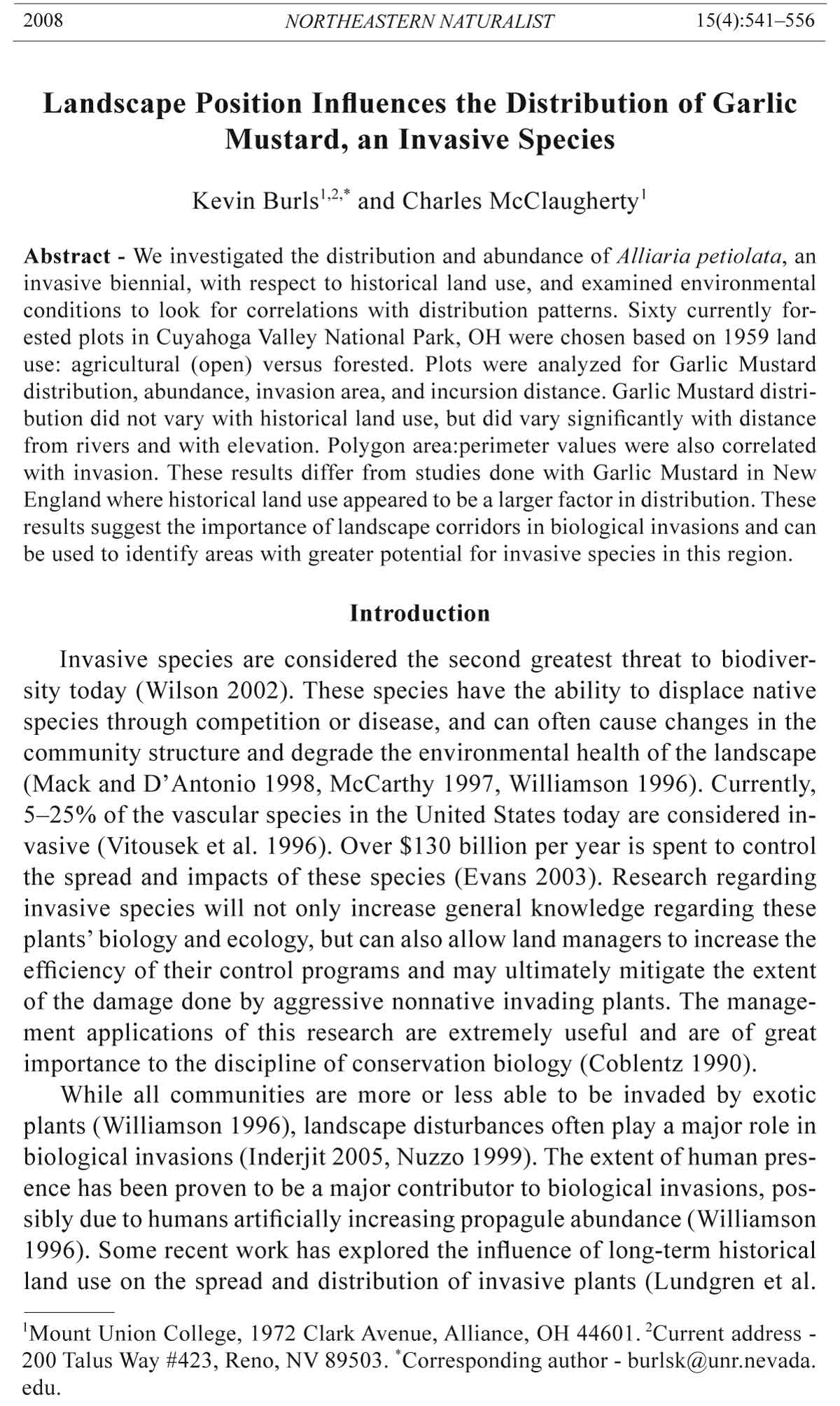
Figure 1a. Land cover of Cuyahoga Valley National Park in 1959.
2008 K. Burls and C. McClaugherty 545
Map 9.1, polygons were created and divided into two categories based on
their 1959 status: agricultural (open) or wooded. All polygons are currently
forested. Each polygon extended at least 150 m along a trail edge and at
least 50 m into the forest interior to establish a buffer from other land-use
categories or mapping inaccuracies. Study polygons, thirty in each category,
were then randomly selected, each at least 1 km from its nearest neighbor.
Study plots inside the polygons, each 2500 m2 in area, were selected
along the trails present through the polygon using the centroid function on
ArcMap and satellite photographs of the area. Plots were rectangular in
shape, extending 100 m long along the trail edge and 25 m into the forest.
Trails, which are pervasive throughout the Park, were used as plot bound-
Figure 1b. Land cover of Cuyahoga Valley National Park in 2002.
546 Northeastern Naturalist Vol. 15, No. 4
aries in order to eliminate them as a variable during analysis. Roads and
pathways are well-known corridors for invasion (Lundgren et al. 2004,
Parendes and Jones 2000), so all sites are at a high risk of modern invasion.
Thus, there is no way to test for the effects of agriculture on historical
Garlic Mustard invasion. The current study examines only whether abiotic
or biotic changes in areas that were historically agricultural have created
conditions that facilitate invasion and establishment.
Plots were surveyed on foot, and any Garlic Mustard found was divided
into edge populations, located between the trail edge and the outer
treeline, or forest populations, extending into the forest past the
outer treeline. Population boundaries inside study plots were delineated
as zones without individual plants for 15 m, which is appropriate given
the normally short dispersal distance of Garlic Mustard (Anderson et al.
1996, Nuzzo 2000). Maximum incursion of the population into the forest
and maximum length along the plot were recorded. Visual measurements
of the abundance of the population were made as the percent of the population’s
maximum area covered by Garlic Mustard in the following
classes: <1.0%, 1.0–3.0%, 3.1–5.0%, 5.1–15.0%, 15.1–25.0%, 25.1–
50.0%, 50.1–75.0%, or >75.0%. Percent canopy cover was measured at
the center of each plot at 5-m intervals from the trail edge using a convex
spherical densiometer, and qualitative assessments of canopy composition,
stand structure, topography, soil moisture, and common understory
vegetation were recorded. Major disturbances such as power lines, roads,
etc., were avoided by requiring a minimum of a 25-m forested buffer to
the rear of each plot. Slope and aspect were determined from a digital elevation
map using ArcMap, and plot distances from rivers and roads were
determined using GIS layers created by the National Park.
Chi-square analyses were performed on population presence or absence
with respect to land use. Edge and forest environments were very
similar and were therefore merged prior to the analysis of environmental
and plot data. ANOVA tests were run on population invasion class, incursion
distance, and invasion area with respect to land use and with respect
to the study polygon area:perimeter ratio, aspect, slope, canopy cover,
distance from roads, distance from rivers, and elevation. All analyses
were done using SYSTAT 9.
Results
The results of all χ2 analyses and ANOVAs are listed below in Table 1.
Land use was not correlated to Garlic Mustard presence, invasion class,
invasion area, or incursion distance. Mean polygon area:perimeter ratio
differed between agricultural and forest land uses ( 30.35 and 59.91, respectively).
The average slope in degrees also differed between agricultural and
forested land use (10.73 and 27.80, respectively). Garlic Mustard presence
2008 K. Burls and C. McClaugherty 547
varied significantly with both distance from rivers and elevation. The mean
distance to rivers of plots lacking Garlic Mustard was 825.0 m (± 423.7 m
SD) and to plots occupied by Garlic Mustard was 483.6 m (± 365.4 m)
(Fig. 2). Similarly, plots lacking Garlic Mustard had a significantly higher
average elevation (274.4 ± 120.63 m) than did plots occupied by Garlic Mustard
(246.3 ± 38.0 m) (Fig. 3). River distance and elevation were strongly
correlated (P = 0.001, F = 12.39, r2 = 0.176). Analysis of covariance showed
that both elevation and river distance were still significant after removing the
effects of the covariant. Area:perimeter ratio was significantly correlated to
incursion distance and remained correlated (P = 0.027, F = 9.61, n = 7) after
removing sites invaded 25 m into the forest interior; this adjustment was
done to avoid bias in regression analysis caused by plot size limits. Slope
was not significantly correlated to invasion area when historical land use was
used as a covariate.
Discussion
This study investigated the hypothesis that lasting abiotic differences
in forest stands that were used in historical agriculture would cause a differential
distribution and survival of Garlic Mustard. As land-use history
was not found to influence any properties of Garlic Mustard populations,
this differential distribution does not seem to have occurred in the Cuyahoga
valley. This finding is contrary to contemporary research in the New
England region (DeGasperis and Motzkin, in press; Lundgren et al. 2004),
as well as much of the research associated with long-term vegetation com-
Table 1. Results of plot analysis for land use and environmental influence. Asterisks indicate
significant results (P < 0.05).
Alliaria
petiolata Invasion Incursion Invaded
Site or Land use presence class distance area
environmental factor (n = 60) (n = 60) (n = 28) (n = 28) (n = 28)
Area:Perimeter ratio P = 0.000* 0.124 0.679 0.004* 0.100
F = 26.62 2.44 0.66 10.02 2.90
Aspect P = 0.912 0.680 0.549 0.597 0.287
F = 0.01 0.17 0.85 0.29 1.18
Slope P = 0.000* 0.695 0.180 0.150 0.049*
F = 30.30 0.16 1.66 2.20 4.26
Canopy cover P = 0.618 0.582 0.955 0.628 0.932
F = 0.25 0.31 0.24 0.24 0.01
Road distance P = 0.212 0.052 0.137 0.780 0.345
F = 1.59 3.92 1.86 0.08 0.93
River distance P = 0.057 0.002* 0.923 0.103 0.159
F = 3.76 11.01 0.31 2.85 2.10
Elevation P = 0.218 0.001* 0.393 0.283 0.073
F = 1.55 13.03 1.10 1.20 3.48
Land use P = N/A 0.301 0.113 0.869 0.813
F = N/A 1.06 2.69 0.03 0.06
548 Northeastern Naturalist Vol. 15, No. 4
position done by various researchers (e.g., Foster 1992). There are three
main possibilities for this finding: phenotypic variability, edaphic factors,
and scale of disturbance.
First, phenotypic plasticity in plants, and plants’ ability to spread
over wide geographic ranges, are topics of much ongoing research (Sultan
2000). Donohue (2005) reviewed seed dispersal, flowering, and
germination time in Arabidopsis thaliana (L.) Heynh. (Mouseear Crest)
and showed how the timing of each characteristic can influence itself or
interact with other life-history traits to manipulate the environment the
Figure 2. Garlic Mustard population distribution in relation to distance from rivers.
Coloration extends to one standard deviation past the mean distance from rivers for
plots occupied by Garlic Mustard.
2008 K. Burls and C. McClaugherty 549
organism experiences in future generations. This plasticity in phenology,
which then determines the environment of the organism, has been termed
niche construction and influences the phenotypic expression and natural
selection pressures on a given life-history trait (Donohue 2005). Byers and
Quinn (1998) examined the demographic variation in Garlic Mustard in
four contrasting habitats in New Jersey and found flowering time and biomass
allocation to vary significantly among habitats, concluding through
common garden experiments that the plants responded to the range of
habitats mainly through phenotypic plasticity. Thus, plasticity in phenol-
Figure 3. Garlic Mustard population distribution in relation to elevation. Coloration
extends to one standard deviation past the mean elevation of plots occupied with
Garlic Mustard.
550 Northeastern Naturalist Vol. 15, No. 4
ogy by Garlic Mustard in this region may allow it to overcome any environmental
pressures from varying historical land uses. In addition to niche
construction, invasive plants are known to alter the nutrient dynamics of
soils through allelopathy, changing primary productivity rates, or changing
ecosystem processes (Ehrenfeld 2003, Lundgren et al. 2004, Rice 1984,
Vanderhoeven et al. 2005). If a small invasive population has been established
for a long enough period of time, it is possible it may alter the soil
characteristics and promote its own spread.
Second, the “soil signature” of soils in Ohio, mainly alfisols, is
very different compared to the rockier soils in New England, which are
inceptisols or entisols). Alfisols, which generally have a higher percent
base saturation and total cation exchange and have a finer texture than
entisols and inceptisols (Gardiner and Miller 2003), can lead to different
plant communities in relatively similar climates, and this difference may
hold some important implications for invasive species distributions.
Third, some studies (Anderson et al. 1996, Nuzzo 1999) cite Garlic
Mustard’s ability to capitalize on one-time microdisturbances through
phenotypic plasticity and self-fertilization. Therefore, disturbances that
create distinct microhabitats, such as treefalls or steep shaded slopes, may
be enough for Garlic Mustard to establish a population and spread. Future
studies may find that different limiting factors may control distribution at
different spatial scales (e.g., the factors at play in a treefall versus those on
an entire landscape), obscuring their effects.
As mentioned above, the presence of paths along study plots should
encourage the establishment of Garlic Mustard at all locations, limiting
inferences to long-term abiotic or biotic differences in historically farmed
or forested sites. Surveys of areas that lack paths may show different
conclusions, though this result is unlikely due to the factors mentioned
above. In addition, it would be difficult to locate plots without trails, as
most historically agricultural areas within the Park are in close proximity
to roads and pathways.
Garlic Mustard incursion distance was negatively correlated with polygon
area:perimeter ratio (r2 = 0.527; Table 1). This correlation remained
significant even after removing sites with a 25-m incursion distance. This
measurement is limited due to the plot size, but may hold some importance
when relating Garlic Mustard’s “approach and retreat” advance from disturbances
(Nuzzo 1999), as the edges created by historical agriculture can
change many environmental conditions and may facilitate modern invasions
(Alston and Richardson 2006, Brothers and Springarn 1992, Foster 1992,
Saunders et al. 1991).
Garlic Mustard population distribution was found to increase with
decreasing elevation. This result would suggest that the relatively minor
changes in elevation, approximately 100 m, play some role in the
distribution of Garlic Mustard. This influence has been documented for
2008 K. Burls and C. McClaugherty 551
individual species and community composition in other areas, including
floodplains (discussed below), and can be due to competition with
other plants or differing abiotic variables which may constrain a species’
vertical distribution and realized niche (Funk et al. 2004, Lenssen and de
Kroon 2005, Leyer 2005, Welch et al. 2006). It is also possible that forest
populations of Garlic Mustard, despite any phenotypic plasticity, require a
long-term seed dispersal agent to exist in forest interiors. Data by Stinson
et al. (unpubl. data) suggest that forest populations of Garlic Mustard in
New England may be serving as sink populations, and Nuzzo (1999) found
the rate of spread to be partially dependent on the establishment of satellite
populations. While the mechanism for the spatial pattern observed in
this study is not elucidated, it is possible that seed transport by gravity or
surface water runoff may be responsible as a seed source for populations
at lower elevations and that populations may have a source-sink dynamic.
This dynamic may be especially important for populations in historically
wooded areas, which are often on steeper slopes than previously farmed
landscapes (see above). While not conclusive, this finding holds implications
for land managers and for future studies.
Garlic Mustard population distribution was also negatively correlated
to river distance. This finding seems intuitive when coupled with
the elevation data, as Cuyahoga Valley National Park is innately related
to the river valley and its topography, and elevation and river distance are
strongly correlated (see above). Still, past research suggests this finding
may imply some additional spatial patterning based on location or habitat
variation. The role of water in biological invasions is multifaceted. Observed
rates of spread by Garlic Mustard are well above values predicted
using simple expulsion from the mother plant, indicating a long-term dispersal
agent. Water transport has been identified as a long-distance seed
vector for riparian flora (Andersson et al. 2000, van Eck et al. 2005,Vogt
et al. 2004) as well as for Garlic Mustard (Nuzzo 1993). Rivers may also
serve as corridors for shorter term, distance-dependent seed transport,
and can serve to connect otherwise fragmented communities (Kudoh and
Whigham 1997, Thomas et al. 2006, Vogt et al. 2004). Campbell et al.
(2002) found a strong correlation between predicted dispersal rates and an
analytical model for river-aided seed dispersal and offers this relationship
as an opportunity to predict the invasion of alien species and to compare
with actual invasion rates. Garlic Mustard has a short-lived seed bank
(Baskin and Baskin 1992, Nuzzo 1999), and yearly floods may be important
to both long-distance spread and forest interior incursion. In addition,
the Cuyahoga River valley and its tributaries likely serve as preferred
routes for wildlife and human movement, combining the topography, river
presence, and human presence in the area to create a passive corridor for
seed dispersal. Thus, it may be useful to consider elevation as a proxy for
distance from major dispersal corridors in this geographical context.
552 Northeastern Naturalist Vol. 15, No. 4
However, rivers may also serve to change the abiotic conditions, mainly
risk of drought, and thereby limit species’ distribution; some studies on
the elevation-related phenomena discussed above are found in conjunction
with floodplain environments (Lenssen and de Kroon 2005, Leyer 2005).
Also, Byers and Quinn (1998) found higher survivorship, earlier flowering
phenology, and higher germination rates of Garlic Mustard in floodplain environments
compared to drier environments. While the present study did not
examine the roles of rivers in Garlic Mustard spread, the Cuyahoga River’s
importance in this study area cannot be ignored and should be a point of
study in this and other areas.
This study examined the influence of historical land use on the distribution
and abundance of Garlic Mustard in a river valley environment in northeast
Ohio. While historical land use did not appear to have any influence,
other environmental factors in the region may be limiting the distribution of
Garlic Mustard populations. These trends warrant further studies and may
prove useful to land managers targeting the floodplains to limit the spread of
Garlic Mustard into forest interiors.
In addition to this functional but proximate finding, a more broad-scale
conclusion can be drawn. Studies on invasive plant distributions, and species
distributions in general, like those discussed above, are often somewhat
contradictory. Some studies favor abiotic site conditions (Byers and Quinn
1998, Lenssen and de Kroon 2005, Leyer 2005) or interspecies competition
(Lenssen and de Kroon 2005, Vilà and Weiner 2004 ) as the range-limiting
factor. Other studies attribute geographic limits to seed dispersal limitations
(Andersson et al. 2000, van Eck et al. 2005, Vogt et al. 2004). In addition,
disturbance levels are often believed to favor invasive species dispersal (Inderjit
2005, Nuzzo 1999, Williamson 1996). Historical land use, explored
in the present study, has proven to be a very strong variable in determining
New England plant species composition with both native and invasive species
(Degasperis and Motzkin in press, Donohue et al. 2000, Foster 1992),
but does not appear to play a major role in the Cuyahoga River valley
region. While each of the above variables, in addition to others not mentioned,
certainly plays a role in any given case, it may be prudent to advise
land managers and scientists to take a cautionary stance before assigning a
specific variable as a limiting factor in an invasive species’ niche or as the
main factor in its competitive abilities. In fact, the limiting variables appear
to change depending on the species (Davis 2006), ecoregion (K. Stinson et
al., unpubl. data), and habitat (Byers and Quinn 1998). In the future, a comprehensive
understanding of the invasive species of interest, and specifically
its behavior in the region of interest, should be obtained by land managers
before expending limited resources for its control or extermination. This precaution
will allow their efforts to be more effective and lasting, conserving
our ecosystems’ functionality and biodiversity.
2008 K. Burls and C. McClaugherty 553
Acknowledgments
The authors would like to thank Anthony Gareau and Laura Elze at Cuyahoga
Valley National Park for the use of GIS layers including past and present land-use
information, forest boundaries, and known invasive species locations.
Literature Cited
Alston, K.P., and D.M. Richardson. 2006. The roles of habitat features, disturbance,
and distance from putative source populations in structuring alien plant invasions
at the urban/wildland interface on the Cape Peninsula, South Africa. Biological
Conservation 132:183–198.
Anderson, R.C., S.S. Dhillon, and T.M. Kelley. 1996. Aspects of the ecology of an
invasive plant, Garlic Mustard (Alliaria petiolata), in central Illinois. Restoration
Ecology 4(2):181–191.
Andersson, E., C. Nilsson, and M.E. Johansson. 2000. Plant dispersal in boreal rivers
and its relation to the diversity of riparian flora. Journal of Biogeography
27(5):1095–1106.
Baskin, J.M., and C.C. Baskin. 1992. Seed germination biology of the weedy biennial
Alliaria petiolata. Natural Areas Journal 12:191–197.
Brothers, T.S., and A. Sprigarn. 1992. Forest fragmentation and alien plant invasion
of central Indiana old-growth forests. Conservation Biology 6(1):91–100.
Byers, D.L., and J.A. Quinn. 1998. Demographic variation in Alliaria petiolata
(Brassicaceae) in four contrasting habitats. Journal of the Torrey Botanical Society
125(2):138–149.
Campbell, G.S., P.G. Blackwell, and F.I. Woodward. 2002. Can landscape-scale
characteristics be used to predict plant invasions along rivers? Journal of Biogeography
29:535–543.
Coblentz, B.E. 1990. Exotic organisms: A dilemma for conservation biology. Conservation
Biology 4(3):261–265.
Cockrell, R. 1992. A green shrouded miracle: The administrative history of Cuyahoga
Valley National Recreation Area, Ohio. National Park Service Midwest
Regional Office, Omaha, NE. Available online at http://www.nps.gov/history/
history/online_books/Cuyahoga/toc.htm. Accessed June 27, 2007.
Cross, R. 2002. A “stealth” park slips under the radar screen. Chicago Tribune,
June 9, 2002. Available online at http://www.chicagotribune.com/travel/chi-
020609cuyahogaside,1,679541.story?coll=chi-900siteindex-fea. Accessed June
27, 2007.
Davis, A.S. 2006. When does it make sense to target the weed seed bank? Weed Science
54:558–565.
DeGasperis, B.G., and G. Motzkin. In press. Windows of opportunity: Historical and
ecological controls on Berberis thunbergii invasions. Ecology.
Donohue, K. 2005. Niche construction through phenological plasticity: Life-history
dynamics and ecological consequences. New Phytologist 166:83–92.
Donohue, K., D.R. Foster, and G. Motzkin. 2000. Effects of the past and the present
on species distributions: Land-use history and demography of wintergreen.
Journal of Ecology 88:303–316.
Ehrenfeld, J.G. 2003. Effects of exotic plant invasions of soil nutrient cycling processes.
Ecosystems 5:503–523.
554 Northeastern Naturalist Vol. 15, No. 4
Evans, E.A. 2003. Economic dimensions of invasive species. Choices 18(2):5–9.
Foster, D.R. 1992. Land-use history (1730–1990) and vegetation dynamics in central
New England, USA. Journal of Ecology 80:753–772.
Funk, D.W., L.E. Noel, and A.H. Freedman. 2004. Environmental gradients, plant
distribution, and species richness in arctic salt marsh near Prudhoe Bay, Alaska.
Wetlands Ecology and Management 12:215–233.
Gardiner, D.T., and R.W. Miller. 2003. Soils in Our Environment. Prentice Hall, Upper
Saddle River, NJ. 656 pp.
Guggenberger, G., B.T. Christensen, and W. Zech. 1994. Land-use effects on the
composition of organic matter in particle-size separates of soil: I. Lignin and
carbohydrate signature. European Journal of Soil Science 45:449–458.
Hall, B., G. Motzkin, D.R. Foster, M. Syfert, and J. Burk. 2002. Three hundred years
of forest and land-use change in Massachusetts, USA. Journal of Biogeography
29:1319–1335.
Inderjit. 2005. Plant invasions: Habitat invisibility and dominance of invasive plant
species. Plant and Soil 277:1–5.
Koerner, W., J.L. Dupouey, E. Dambrine, and M. Benoît. 1997. Influence of past land
use on the vegetation and soils of present day forest in the Vosges mountains,
France. Journal of Ecology 85:351–358.
Kudoh, H., and D.F. Whigham. 1997. Microgeographic genetic structure and gene
flow in Hibiscus moscheutos (Malvaceae) populations. American Journal of
Botany 84(9):1285–1293.
Lenssen, J.P.M., and H. de Kroon. 2005. Abiotic constraints at the upper boundaries
of two Rumex species on a freshwater flooding gradient. Journal of Ecology
93:138–147.
Leyer, I. 2005. Predicting plant species’ responses to river regulation: The role of
water-level fluctuations. Journal of Applied Ecology 42:239–250.
Lundgren, M.R., C.J. Small, and G.D. Dreyer. 2004. Influence of land use and site
characteristics on invasive plant abundance in the Quinebaug Highlands of southern
New England. Northeastern Naturalist 11(3):313–332.
Mack, M.C., and C.M. D’Antonio. 1998. Impacts of biological invasions on disturbance
regimes. Trends in Ecology and Evolution 13(5):195–198.
McCarthy, B.C. 1997. Response of a forest understory community to experimental
removal of an invasive nonindigenous plant (Alliaria petiolata, Brassicaceae).
Pp. 117–128, In J.O. Luken and J.W. Thieret (Eds.). Assessment and Management
of Plant Invasions. Springer-Verlag Publishing, New York, NY. 324 pp.
Motzkin, G., D.A. Orwig, and D.R. Foster. 2002. Vegetation and disturbance history
of a rare dwarf Pitch Pine community in western New England, USA. Journal of
Biogeography 29:1455–1467.
National Oceanic and Atmospheric Administration (NOAA). 2005. Comparative
climatic data for the United States through 2006. Available online at http://www1.
ncdc.noaa.gov/pub/data/ccd-data/CCD_2006.pdf. Accessed July 19, 2007.
Natural Resources Conservation Service (NRCS). 2007. Distribution maps of dominant
soil orders. Available online at http://soils.usda.gov/technical/classification/
orders/. Accessed June 27, 2007.
Nuzzo, V. 1993. Distribution and spread of the invasive biennial Alliaria petiolata
(Garlic Mustard) in North America. Pp. 137–145, In B.N. McKnight (Ed.). Biological
Pollution. Indiana Academy of Science, Indianapolis, IN. 261 pp.
2008 K. Burls and C. McClaugherty 555
Nuzzo, V. 1999. Invasion pattern of the herb Garlic Mustard (Alliaria petiolata) in
high-quality forests. Biological Invasions 1:169–179.
Nuzzo, V. 2000. Elemental stewardship abstract for Alliaria petiolata (Alliaria
officinalis) Garlic Mustard. The Nature Conservancy, Elemental Stewardship
Abstracts, Arlington, VA.
Ohio Department of Natural Resources (ODNR). 2006. History of Ohio’s canals.
Available online at http://www.ohiodnr.com/water/canals/canlhist.htm. Accessed
November 18, 2006.
Parendes, L.A., and J.A. Jones. 2000. Role of light availability and dispersal in
exotic plant invasion along roads and streams in the H.J. Andrews Experimental
Forest, Oregon. Conservation Biology 14(1):64–75.
Rice, E.L. 1984. Allelopathy. Academic Press, New York, NY. 422 pp.
Roberts, K.J., and R.C. Anderson. 2001. Effect of Garlic Mustard (Alliaria petiolata
[Bieb.] Cavara & Grande)] extracts on plants and arbuscular mycorrhizal (AM)
fungi. American Midland Naturalist 146:146–152.
Saunders, D.A., R.J. Hobbs, and C.R. Margules. 1991. Biological consequences of
ecosystem fragmentation: A review. Conservation Biology 5(1):18–32.
Simpson, J.W., R.E.J. Boerner, M.N. DeMers, L.A. Berns, F.J. Artigas, and A. Silva.
1994. Forty-eight years of landscape change on two contiguous Ohio landscapes.
Landscape Ecology 9(4):261–270.
Stinson, K.A., S.A. Campbell, J.R. Powell, B.E. Wolfe, R.M. Callaway, G.C. Thelen,
S.G. Hallett, D. Prati, and J.N. Klironomos. 2006. Invasive plant suppresses the
growth of native tree seedlings by disrupting belowground mutualisms. PLoS
Biology 4(5):e140.
Sultan, S.E. 2000. Phenotypic plasticity for plant development, function, and life
history. Trends in Plant Science 5(12):537–542.
Thomas, J.R., B. Middleton, and D.J. Gibson. 2006. A landscape perspective
of the stream corridor invasion and habitat characteristics of an exotic (Dioscorea
oppositifolia) in a pristine watershed in Illinois. Biological Invasions
8:1103–1113.
Tikka, P.M., H. Högmander, and P.S. Koski. 2001. Road and railway verges serve as
dispersal corridors for grassland plants. Landscape Ecology 16:659–666.
Van Eck, W.H.J.M., H.M. van de Steeg, C.W.P.M. Blom, and H. de Kroon. 2005.
Recruitment limitation along disturbance gradients in river floodplains. Journal
of Vegetation Science 16:103–110.
Vanderhoeven, S., N. Dassonville, and P. Meerts. 2005. Increased topsoil mineral
nutrient concentrations under exotic invasive plants in Belgium. Plant and Soil
275:169–179.
Verheyen, K., B. Bossuyt, M. Hermy, and G. Tack. 1999. The land-use history
(1278–1990) of a mixed hardwood forest in western Belgium and its relationship
with chemical soil characteristics. Journal of Biogeography 26:1115–1128.
Vilà, M., and J. Weiner. 2004. Are invasive species better competitors than native
plant species? Evidence from pair-wise experiments. OIKOS 105:229–238.
Vitousek P.M., C.M. D’Antonio, L.L. Loope, and R. Westbrooks. 1996. Biological
invasions as global environmental change. American Scientist 84(5):468–479.
Vogt, K., L. Rasren, and K. Jensen. 2004. Water-borne seed transport and seed
deposition during flooding in a small river-valley in northern Germany. Flora
199:377–388.
556 Northeastern Naturalist Vol. 15, No. 4
Welch, B.A., C.B. Davis, and R.J. Gates. 2006. Dominant environmental factors
in wetland plant communities invaded by Phragmites australis in East Harbor,
Ohio, USA. Wetlands Ecology and Management 14:511–525.
White, M.A., and D.J. Mladenoff. 1994. Old-growth forest landscape transitions
from pre-European settlement to present. Landscape Ecology 9(3):191–205.
Williamson, M. 1996. Biological Invasions. Chapman and Hall Publishing, London,
UK. 244 pp.
Wilson, E.O. 2002. The Future of Life. Knopf (Random House) Publishing, New
York, NY. 229 pp.
Wolfe, B.E., and J.N. Klironomos. 2005. Breaking new ground: Soil communities
and exotic plant invasion. BioScience 55(6):477–487.