Spatial Variation in Stream Water Quality in Relation to Riparian Buffer Dimensions in a Rural Watershed of Eastern New York State
Sean S. Madden, George R. Robinson, and John G. Arnason
Northeastern Naturalist, Volume 14, Issue 4 (2007): 605–618
Full-text pdf (Accessible only to subscribers.To subscribe click here.)
Access Journal Content
Open access browsing of table of contents and abstract pages. Full text pdfs available for download for subscribers.
Current Issue: Vol. 30 (3)

Check out NENA's latest Monograph:
Monograph 22


2007 NORTHEASTERN NATURALIST 14(4):605–618
Spatial Variation in Stream Water Quality in Relation to
Riparian Buffer Dimensions in a Rural Watershed of
Eastern New York State
Sean S. Madden1,2,*, George R. Robinson1, and John G. Arnason3
Abstract - Studies of forested rural watersheds provide estimates of background
contamination for comparison with streams and rivers in other settings. We
performed a landscape analysis and measured major dissolved ions and benthic
macroinvertebrates for a small rural watershed in Albany County, NY, to determine
spatial variation in water quality. An estimated 73% of the surface cover is
post-agricultural forest, with only 2.3% of the watershed covered by roads and
other impervious surfaces. Although water quality was consistently high in most of
the creek, we detected three relatively distinct zones separated by impoundments;
zonation was most apparent in relative concentrations of major ions, less so with
benthic macroinvertebrate community similarity. At ten sample stations, buffer size,
measured as upstream land cover and distance to nearest road, did not correlate well
with chemical water quality indicators. In particular, we found the highest levels of
chloride, indicative of road-salt contamination, in areas of maximum forest buffer.
Small feeder creeks that drain nearby roads may function as “leaks” in otherwise
well-buffered watersheds with low road densities.
Introduction
Forested, rural watersheds supply much of the drinking water in
the northeastern US, and also serve as reference study sites, useful for
determining levels and effects of background contaminants, such as atmospheric
pollution (e.g., Likens 2004). We studied the rural Ten Mile Creek
watershed as a reference study area to examine relationships between
riparian vegetation and water quality. In more urbanized regions, high levels
of impervious surface cover are associated with degradation of stream
water quality, and fine-scale variation can be detected in stream reaches
with and without riparian buffers (Groffman et al. 2003, Paul and Meyer
2001, Roy et al. 2005, Walsh et al. 2005). However, even rural watersheds
have the potential for spatial variability in water chemistry, in part because
land cover in the region derives from a relatively fine-scale mosaic of
land- and water-use history (Mladenoff et al. 1993, O’Neill et al. 1988).
Rural streams also receive substantial amounts of non-point contamination,
via atmospheric deposition, agricultural runoff, and highway deicing
1Program in Biodiversity, Conservation and Policy, University at Albany, 1400
Washington Avenue, Albany, NY 12222. 2Division of Fish, Wildlife and Marine
Resources, New York State Department of Environmental Conservation, 625
Broadway, Albany, NY 12233. 3Department of Earth and Atmospheric Sciences,
University at Albany, 1400 Washington Avenue, Albany, NY 12222. *Corresponding
author - ssmadden@gw.dec.state.ny.us.
606 Northeastern Naturalist Vol. 14, No. 4
agents (Jones et al. 2000, Kaushal et al. 2005). With expanding incursions
of urban fringes into rural lands throughout North America (Elvidge et al.
2004), impending land-cover change has prompted renewed interest in the
buffering capacity of forest cover, driven by concerns for watershed conservation
(Palmer et al. 2004, Theobald 2004).
A common expectation in watersheds of all land-cover types is that riparian
buffer width is positively correlated with stream water quality (Castelle
et al. 1994, Clausen et al. 2000, Correll 2000, Fischer et al. 2000, Spruill
2000). Riparian zones sequester sediments and non-point source pollutants,
slow surface fl ow, stabilize stream banks, moderate stream temperatures, and
serve as important denitrifi cation sites (Correll 2000, Groffman et al. 2003).
Low road densities and intact riparian forests are two of the characteristics
that make rural watersheds attractive as reference sites, but anticipated landuse
change may place greater demands on a reduced buffering capacity.
We tested for spatial variation present in this rural watershed by examining
stream water chemistry and benthic macroinvertebrate diversity
in comparison to riparian buffer size and surrounding land cover. In the
process, we found significantly higher levels of chloride contamination
in areas of maximum forest buffer width. In addition, concentrations of
major dissolved ions revealed potential contamination not evident from
biotic sampling.
Methods
Site description
The headwaters of Ten Mile Creek are located at approximately 600
m in elevation in the Partridge Run Wildlife Management Area of Albany
County, NY. The creek flows south into Greene County, where it joins
Catskill Creek, a major tributary of the Hudson River. The creek drains a
predominately well-forested and post-agricultural watershed (57.7 km2)
with no current industrial point sources or urban land use. The watershed
supports a low population density, but rural Albany County is projected
to experience significant population growth and associated suburban development
within the next ten years (Capital District Regional Planning
Commission 2005). The study area comprises the uppermost 10 km of
creek, draining 26.9 km2 of the watershed where most of the creek is bordered
by the 75-year-old Edmund Niles Huyck Preserve and Biological
Research Station (http://www.huyckpreserve.org/). Within the study area,
the creek passes through two impoundments—Lincoln Pond (4 ha) and
Lake Myosotis (44 ha)—and the Hamlet of Rensselaerville, which receives
drinking water from the latter impoundment.
In the study area, the bedrock geology consists of sandstones, siltstones, and
shales of the Lower Hamilton Group. Surfi cial geology consists of thin (<1 m)
glacial till deposits in upland areas with thicker (up to 30 m) glacial outwash
deposits of sand and gravel in stream channels and low-lying areas. As a result
of glaciation and erosion from past agriculture, the soils are generally shallow,
2007 S.S. Madden, G.R. Robinson, and J.G. Arnason 607
poorly draining silt loams. Mineral soils are acidic, in the range of pH 3.5 in old
hemlock stands to 6.0 in deciduous forests (Wyman 1988).
Except for miscellaneous records from private wells, there is little information
on groundwater. Within the town of Rensselaerville, wells in bedrock
yield an average of 0.5 L s-1, whereas wells in unconsolidated deposits yield
1.3 L s-1 (Bagdon Environmental Associates 1989). It is likely that groundwater
fl ow in bedrock is fracture-controlled, occurring along joints and bedding
planes, whereas porous fl ow occurs through unconsolidated sand and gravel
deposits. Groundwater recharge would be expected to be higher in areas
overlain by unconsolidated sand and gravel compared to areas overlain by
relatively impermeable till.
While the Ten Mile Creek catchment appears well forested today, it is far
from pristine and has a history of timber harvesting, milling, and industry
(Wyman 1988). Some active agriculture is still present in parts of the watershed,
but most fi elds are in mid- to late stages of succession to closed-canopy
forest. Although some remnant old-growth forest remains on steep slopes in
the valley, most forest cover is second and third growth. Housing is dispersed
and on the fringe of rural and natural lands except for concentrated settlement
in the Hamlet of Rensselaerville (2000 US Census population = 528).
Ten sample sites were chosen within the study area (Fig. 1). Site selection
was designed to capture potential spatial variation, including sampling above
and below the impoundments and above and below the Hamlet of Rensselaerville.
Two sites were clustered at outlets from Lake Myosotis, one to sample
spillway overfl ow and the other to sample a deep-water outlet, which converge
approximately 50 m downstream.
Landscape analysis
A geographic information system (GIS) database was developed using
ESRI ArcGIS 8.3TM to conduct watershed mapping and analysis. Digital
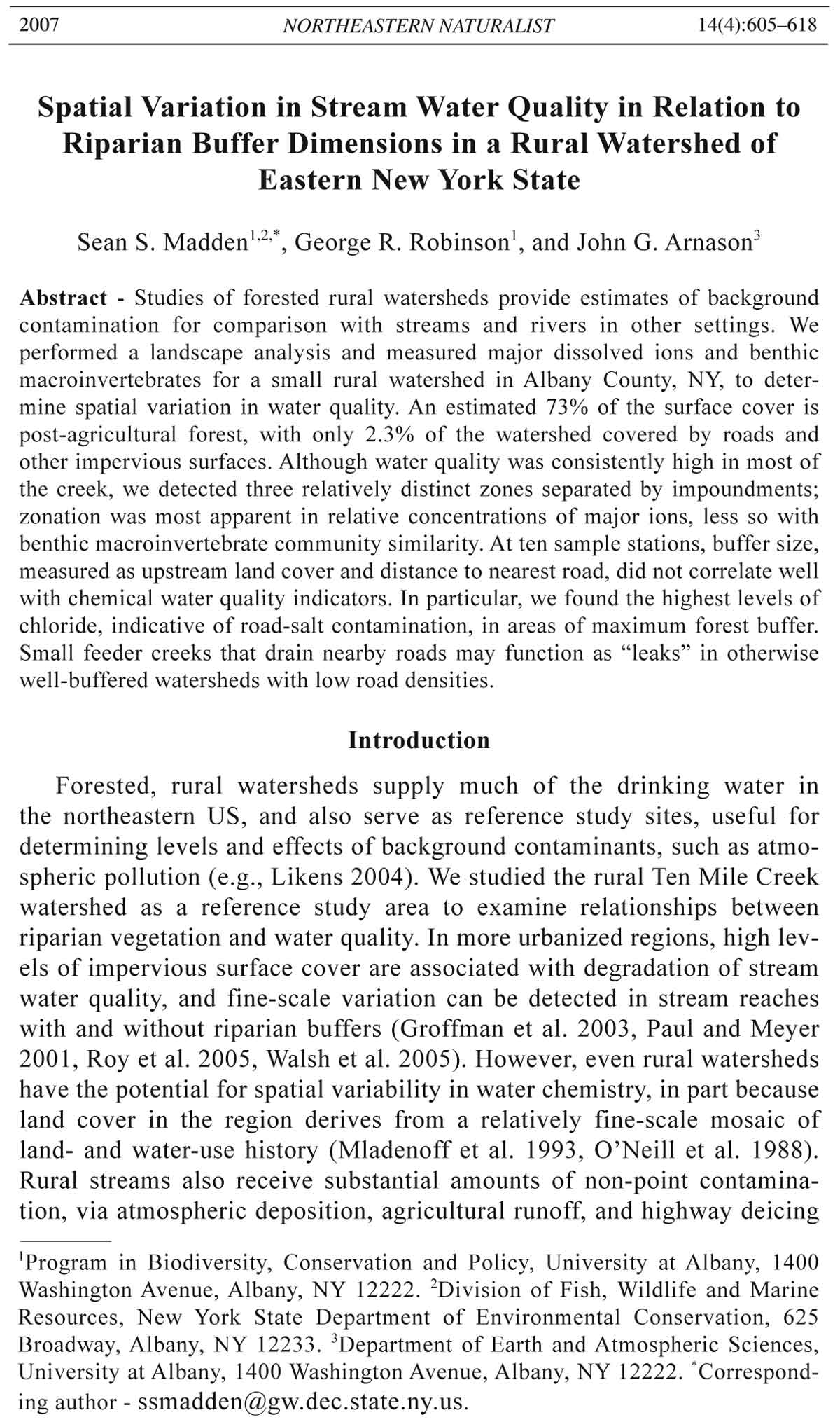
Figure 1. Ten Mile Creek Study Watershed, Albany County, NY. The study area is
the northern half of the 57.7-km2 Ten Mile Creek watershed. Sampling sites are
numbered 1 through 10 and were grouped into sections to test for spatial variability.
Two small tributaries (Tributary 1 and Tributary 2) were also sampled as part
of the study.
608 Northeastern Naturalist Vol. 14, No. 4
ortho-images were downloaded from the New York State GIS Clearinghouse
(www.nysgis.state.ny.us) to provide a base map for the impervious
surface and land-use analysis. A watershed boundary for Ten Mile Creek
was obtained from the Capital District Regional Planning Commission
(T. Fabozzi, Capital District Regional Planning Commission, Albany, NY,
pers. comm).
Land use and land cover within the watershed was divided into 14 categories.
Each category was hand-digitized over orthophotographic layers,
and the surface area for each category was calculated. Interpretations were
corrected using others sources, including USGS and NYS Department of
Transportation base maps, satellite imagery, researcher’s maps from the
E.N. Huyck Preserve, and ground reconnaissance. All impervious and semipervious
surface categories within the watershed boundary were summed to
create total percent of impervious surfaces for the watershed. A powerline
corridor bisecting a northern portion of the watershed was categorized as
impervious, because it includes compacted roadbeds and because the vegetation
had recently been cut back.
Riparian buffer composition and minimum buffer width
At each mapped water-collection point, a 16-ha polygon was created
that established a zone 200 m on each side of the point and 400 m upstream.
Riparian buffer composition was measured as the percentage of forest versus
impervious surface within that upstream zone. A separate buffer characteristic,
minimum buffer width, was measured as the straight-line distance to
the nearest impervious surface upgradient of each sample point. Sampling
sites at outlets of the two impoundments were excluded, because their source
waters derive from a much broader landscape than their immediate surroundings.
Riparian buffer composition and minimum width were regressed
against water-quality variables to test for potential relationships.
Water sampling and analysis
From May 2003 through April 2004, water samples were collected the
fi rst week of every month from the ten sampling sites along Ten Mile Creek.
Samples were collected without consideration of prior storms or fl ow conditions.
Stream temperature and dissolved oxygen were measured, and a
100-ml water sample was collected. Two sites were inaccessible for one or
two sampling periods, so the dataset reported contains 117 samples. In the
laboratory, water samples were passed through a 0.45-μm Millipore fi lter,
and pH was measured using a Thermo Orion pH Electrode (Model 915
7BN). Filtered samples were analyzed for concentrations of major anions
(fl uoride, chloride, nitrate, phosphate, and sulfate) and cations (sodium,
potassium, ammonium, magnesium, and calcium), using Dionex DX-120
and ICS-90 ion chromatograph systems run with ChromeleonTM software.
Protocols followed US EPA method 300.1 (EPA 1997).
Climate data, including precipitation and departure from normal precipitation,
were obtained for the sample period from the National Climatic
2007 S.S. Madden, G.R. Robinson, and J.G. Arnason 609
Data Center (www.ncdc.noaa.gov/oa/ncdc) maintained by the National
Oceanographic and Atmospheric Administration. The Albany Airport
weather station (42°45'N, 73°48'W) was used as the climate data source.
Although there are several weather stations closer to the study area, Albany
Airport had the most complete climate records available for May 2003
through April 2004.
Stream invertebrate sampling and analysis
We collected stream macroinvertebrates near fi ve of the ten watersampling
sites in both early July and early August. Sample locations were
selected for similar depth, fl ow, and shade characteristics; three sites
were chosen because of their use in previous New York State Department
of Environmental Conservation (NYS DEC) monitoring (Abele et al.
1998). Traveling kick samples were used, following protocols of the Stream
Biomonitoring Unit of the NYS DEC (Bode at al. 2002).
Macroinvertebrates in each sample were counted and identifi ed to order
and family to calculate four water-quality indices modifi ed from Bode
et al. (2002): Family richness (the number of families identifi ed in each
sample), EPT richness (the number of families representing the three orders
Ephemeroptera, Plecoptera, and Trichoptera), family biotic index (a
measure of the tolerance of the families represented based on established
values for sensitivity [Hilsenhoff 1988]), and percent model affi nity (comparing
sample community structure to a model non-impacted community).
Data from these four indices were converted to a 10-scale scoring regime
modifi ed from Bode et al. (2002) for family-level indices (A.J. Smith and
R. Bode, NYS DEC, Stream Biomonitoring Unit, Albany, NY, pers. comm.),
and samples from July and August were averaged. Once converted, the four
indices were then averaged to calculate what Bode et al. (2002) describes as
a biological assessment profi le for each sample site, which measures whether
water quality at a site is severely, moderately, slightly, or non-impacted. In
addition, invertebrate composition among sites was compared on the basis
of taxonomic similarity at the family level. Our prediction was that samples
would cluster within each of three reaches (above the impoundments, below
impoundments, and below the Hamlet).
Statistical methods
To determine temporal trends, data from all sample sites were pooled
and means were calculated for water chemistry variables for each month
and months grouped by season (sampling occurred the fi rst week of every
month; winter = Jan–Mar, spring = Apr–Jun, summer = Jul–Sept, and autumn
= Oct–Dec). Single-factor ANOVA analyses were conducted for all
water-chemistry data to test for seasonal variation with season as a factor,
with post-hoc Bonferroni tests for pairwise comparison. Spatial trends
were determined by plotting the sample-site means in relation to location.
We used a semi-variogram analysis to assess spatial autocorrelation for
610 Northeastern Naturalist Vol. 14, No. 4
measurements with high variance among sample sites. Chloride ion concentrations
exhibited the highest variance, which reached a threshold (sill) at
an inter-sample distance (lag) below 1 km, the approximate mean distance
between adjacent sample sites (Table 1). Sodium and chloride ion concentrations
were converted to molar equivalents and compared for all pooled
water samples using linear regression.
Cluster analysis was used to test for spatial variability in the invertebrate
community among the fi ve sample sites on Ten Mile Creek. We tested for
similarity among all site pairs, using the Curtis-Bray Index,
CN
= 2jN / (aN + bN),
where aN = total number of individuals in site A; bN = total number of individuals
in site B; jN = the sum of the lower of the two abundances recorded
for species found in both areas (Magurran 1988).
To assess spatial pattern in water chemistry, we used discriminant function
analysis (DFA) based on the 12 monthly samples at each site for all ten
anions and cations. As with invertebrates, the prediction was that sample
sites would cluster into three sections, above the main impoundment (I),
below the impoundments (II), and below the hamlet (III) (Fig. 1). DFA uses
eigenanalysis to identify factor-loading scores for each ion using one or
more canonical axes, and to generate spreads of data points corresponding
to sample site/period combinations. We used a jackknife iteration option in
SYSTAT®11 to estimate probabilities that data points in each of the three
pre-determined clusters were correctly assigned (expressed as percent of
points nearest the correct centroid for each section).
Linear regressions were used to test for relationships between concentrations
of selected ions and riparian buffer width and composition. Sodium
concentration was regressed on chloride concentration (both in mEq) to test
for a potential contribution from de-icing road salt. All statistical analyses
were performed with SYSTAT®11 software.
Table 1. Impervious surface, forest cover, and the next largest land-cover classifi cation expressed
as a percentage of total area of upstream buffer zone (16 ha) and minimum buffer
(distance from sample point to nearest upstream impervious surface). Stream km is measured
from an estimate of the stream headwater (0.0 km). Sample sites immediately below impoundments
are excluded.
% (%) Min
Stream Stream impervious % forest buffer
Site km section cover cover Next largest land cover width (m)
1 0.88 1 2.25 96.76 Wetland (0.99%) 3.2
2 2.57 1 2.03 92.66 Wetland (3.98%) 234.8
3 4.86 1 0.00 80.99 Old fi eld (19.01%) 382.4
5 5.71 1 3.22 92.50 Open water (4.28%) 183.1
8 7.62 2 0.77 91.39 Residential lawn (5.73%) 139.4
9 8.15 3 14.25 54.14 Residential lawn (31.39%) 35.9
10 9.29 3 0.00 97.61 Old fi eld (1.06%) 207.8
2007 S.S. Madden, G.R. Robinson, and J.G. Arnason 611
Results
Landscape and riparian buffer characteristics
Major land cover of the watershed consisted of mixed deciduous forest
(50.17%), coniferous forest (22.86%), agricultural fi eld (9.76%), successional
old fi eld (9.85%), open water (1.69%), wetland (1.29%), and meadow
(1.07%). Lawns, paved roads, dirt roads, powerlines, rooftops, and parking
lots each represented <1% of land cover. Together, these impervious surfaces
covered only a small fraction (2.3%) of the study area.
Most sample sites had relatively large buffer zones, with little nearby
impervious surface and high forest cover (Table 1). Percent impervious surface
in the 16-ha buffer zones were all below 3.22%, with the exception of
site 9 (below the hamlet) which had 14.25% impervious surface cover. Site
3 and site 10 had 0.0% impervious surface cover in their respective buffer
zones. Minimum buffer width is low near the headwaters and at site 9 (below
Hamlet of Rensselaerville) due to close proximity of roads. Minimum buffer
width was negatively but weakly correlated with percent impervious surface
(R = -.517, N = 7, p = .197); a less stringent measure of width would yield a
stronger relationship.
Seasonal and spatial variation in water chemistry
Precipitation during the period of sampling was 24.9 mm greater than
normal. Most of the water chemistry sampling dates had precipitation within
the seven days prior to sampling, indicating that conditions in the creek were
likely above basefl ow. Seven of the sampling months had precipitation in the
form of snow in the seven days prior to sampling.
Most variation in pH was seasonal, ranging from a mean of 7.1 in winter
(January–March) months to 7.8 in summer (June–September). Seasonal
variation was signifi cant overall (ANOVA F3,113 = 30.34, p < 0.001), and winter
pH was signifi cantly lower than all other seasons (Bonferroni test at 95%
level). Phosphate and nitrate concentrations were relatively low (Table 2).
Seasonal variation in chloride concentrations was small when all sample
sites were pooled (range of seasonal means: 7.1 to 13.3 mg l-1; ANOVA F3,113
= 0.89, p = 0.46), but spatial variation was apparent, with increasing concentrations
downstream (Fig. 2).
Table 2. Mean concentrations (mg l-1), concentration ranges (maximum = Max; minimum =
Min; standard deviation = Sd), and standard error (SE) of major ions for all sample locations and
sampling periods pooled (N = 117). “-” = not detectable within our calibration settings.
F- Cl- NO3
- PO4
3- SO4
4- Na+ NH4
+ K+ Mg2+ Ca2+
Mean 0.02 10.23 0.51 0.02 4.73 7.49 0.23 1.09 1.84 14.41
Sd 0.06 14.34 1.14 0.05 3.48 7.57 0.31 0.78 0.49 4.49
Min - 0.28 - - - 0.81 - 0.18 0.12 0.38
Max 0.54 85.17 9.47 0.28 38.43 42.87 2.94 6.30 3.50 33.37
SE 0.01 1.33 0.11 0.01 0.32 0.70 0.03 0.07 0.05 0.42
612 Northeastern Naturalist Vol. 14, No. 4
Spatial variation was also evident for ion concentrations using DFA
(Fig. 3). Much of the multivariate pattern is explained by Factor 1, which
is strongly correlated with sodium and chloride, as well as several other
cations. As with chloride alone (Fig. 2), the three sections are quite distinct,
supporting our predictions that differences would be detectable below the
main impoundment and below the hamlet. However, it is interesting that
chloride levels were highest at the furthest downstream site, more than 1
km south of the hamlet. Two small streams enter Ten Mile Creek between
the hamlet and site 10 (Fig. 1). Although we only collected water-chemistry
data on the tributaries from three sampling events, Cl concentrations were
consistently greater in the tributaries than at site 10 (Table 3).
Figure 2. Mean chloride ion
concentrations per sample site
along Ten Mile Creek from
twelve monthly samples. Error
bars represent one Sd.
Figure 3. Discriminant-function diagram and standardized canonical discriminantfunction
loadings for the 10 major ions collected for 12 months at ten sampling
sites along Ten Mile Creek. Ellipses represent 95% confi dence intervals around centroids
(mean x-y value per section ± 5%) for data points assigned to each section.
Jack-knifed estimates indicate high levels of confi dence in clustering (95% correct
for Section 1, 88% for Section 2, and 83% for Section 3). Eigenvalues were 6.58
(Factor 1) and 0.24 (Factor 2).
2007 S.S. Madden, G.R. Robinson, and J.G. Arnason 613
Sources of chloride ion were probably not confined to NaCl. Regressing
Na on Cl concentrations produced a slope <1:1 for May–October
samples (regression: N = 59, mEq Na = 0.082 + 0.876 [ ±0.038] mEq Cl),
and even lower slope for November–April samples (regression: N = 58,
mEq Na = 0.104 + 0.784 [±0.024] mEq Cl). Although cation exchange
with soils and sediments may explain some of the imbalance, other components
of deicing salts (MgCl2 and CaCl2) may have contributed. In
addition, calcium chloride is applied to gravel roads and driveways during
warm months to reduce dust in the region (R. Wyman, E.N. Huyck
Preserve, Rensselaerville, NY, pers. comm.).
Spatial variation of invertebrate communities
Twenty-nine families of benthic macroinvertebrates, representing 11 orders,
were found among the fi ve sample sites. All biotic indices were in high
(unimpaired) ranges and values for three sites (Sites 8, 9, and 10) were in the
same ranges as previously reported (Table 4; Abele et al. 1998). In contrast
to the pattern of increasing downstream chloride contamination, no spatial
pattern was evident. However, when examined on the basis of taxonomic
composition, sites clustered into three somewhat distinct groups (Fig. 4),
corresponding to the pattern observed for major ions (Fig. 3).
Buffer properties compared to water quality
Our main objective, to examine associations between riparian buffer
properties and water-quality indicators, was diffi cult to meet because low
Table 4. Benthic invertebrate indices from two pooled samples taken at fi ve sites. Family
Rich = family richness; EPT Rich = family richness in the orders Ephemera, Plecoptera, and
Trichoptera; Family BI = family biotic index; PMA = percent model affi nity; and BAP = biological
assessment profi le. Water quality impact (WQI) for the combined indices is assigned
one of four general categories from severe to none (Bode et al. 2002). Sites with asterisks are
in proximity to past monitoring locations for the NYS DEC Stream Biomonitoring program and
previous values for these indicators are included in parentheses (Abele et al. 1998). NYS DEC
data represents species-level indices for richness and biotic index.
Index Site 3 Site 5 Site 8* Site 9* Site 10*
Family richness 10.0 6.5 6.3 (6.8) 7.8 (6.2) 8.1 (7.1)
EPT richness 8.3 7.3 7.0 (5.5) 7.3 (5.5) 7.9 (7.3)
Family BI 8.3 8.4 6.9 (6.7) 6.3 (6.8) 7.6 (8.2)
PMA 7.7 7.9 8.4 (5.3) 7.3 (4.8) 7.9 (7.3)
BAP 8.6 7.5 7.1 (6.1) 7.2 (5.8) 8.0 (7.5)
WQI none none/slight none/slight none/slight none
Table 3. Chloride concentrations (ppm) measured in two small tributaries to Ten Mile Creek and
compared to sample sites above and below where the tributaries enter for the same sample period.
Sample site August 2003 December 2003 February 2004
Site 9 12.55 6.47 15.20
Tributary 1 79.98 88.53 16.60
Tributary 2 53.51 104.67 69.19
Site 10 23.86 18.87 34.27
614 Northeastern Naturalist Vol. 14, No. 4
variability in the macroinvertebrate indices offered low statistical power.
Chloride ion concentrations were quite variable, but means were poorly correlated
with minimum buffer width (N = 7, R = 0.105), forest cover (N = 7;
R = 0.110), or total impervious cover (N = 7; R = 0.149). Variability in other
major ions was likewise not correlated with buffer properties.
Discussion
Along a continuum of water quality, forested headwaters contribute relatively
pure water that gets degraded downstream by changing land use and
new inputs (Groffman et al. 2003, Paul and Meyer 2001). For this rural watershed,
we predicted that impoundments and a small residential community
would produce measurable variation in an otherwise homogeneous stream.
Surrounding land cover, however, was an inadequate predictor of variation,
primarily due to unanticipated “leaks” in the putative forest buffer.
The highest levels of sodium and chloride were found in the stream reach
with the highest percentage of forest cover and maximum distance from
impervious surfaces (site 10). Likely sources for sodium and chloride in the
stream water are 1) discharge of naturally saline groundwater directly into
the hyporheic zone, and 2) road salt in surface runoff or shallow groundwater.
Without data on groundwater chemistry, it is not possible to rule out the
fi rst source. However, elevated sodium chloride concentrations measured
in two small streams draining roadways and entering Ten Mile Creek just
above site 10 are consistent with a road-salt source. Furthermore, chloride
concentrations peaked during winter months, when deicing salts are applied.
This contamination was not revealed in biotic indices derived from macroinvertebrate
collections, although there was evidence of differentiation in
taxonomic composition.
Non-point road runoff of chloride into streams has been most often associated
with urban and suburban watersheds, but it is a growing concern in
rural watersheds as well (Kaushal et al. 2005). It is particularly interesting
that chloride levels at particular locations remained elevated throughout the
year, a pattern noted elsewhere (Kaushal et al. 2005). Lovett et al. (2005)
and Bastviken et al. (2006) found that forest soils can act as both sinks and
sources for chloride, although all the conditions that regulate the retention
or release of chloride are not well understood.
Figure 4. Additive-cluster diagram
based on Curtis-Bray similarity matrix
for invertebrate family (N = 29) composition
and relative abundance per
sampling site. Sites 3 and 5 are above
Lake Myosotis (Section I), Site 8 is
above the Hamlet of Rensselaerville
(Section II), and Sites 9 and 10 are below
the hamlet (Section III).
2007 S.S. Madden, G.R. Robinson, and J.G. Arnason 615
While groundwater inputs provide possible explanations for the observed
spatial variation in chloride we observed, in rural Ten Mile Creek, non-point
runoff seems more likely. The fact that much of our sampling occurred
under conditions above basefl ow and during a wet year makes it diffi cult
to generalize, but surface runoff seems to be a path for Cl to reach streams
throughout the year. Concentrations increased in the vicinity of the hamlet,
but continued to increase and reach their highest levels well downstream
(>1 km), in a reach with the widest forest buffers. We traced these consistently
higher chloride levels to two small feeder creeks with direct contact
to nearby roads. Although the watershed has very low road densities, these
small tributaries may be serving as direct conduits for non-point-source pollutants.
Jackson and Jobbagy (2005) have suggested that a Na:Cl ratio of
less than 0.65:1 can be used to infer that the dominant path for Cl reaching
streams is through the soil. Our ratios for Ten Mile Creek were much closer
to 1:1, indicating that surface fl ow may dominate.
Biotic effects of chronic low-level chloride contamination in streams
are poorly documented. Work with acute doses has identified sensitive
aquatic organisms, but at concentrations well above our highest mean estimates
(e.g., caddisfly acute mean value = 4039 mg/L, almost 50 times our
highest Cl concentration; reviewed in USEPA 1988). Stream contamination
is often reflected in the composition of algal and invertebrate communities
(Audette 2004, Demers and Sage 1990, Dickman and Gochnauer 1978,
Dussart 1984, Metzeling 1993), and benthic macroinvertebrates are considered
relatively sensitive (USEPA 1988), but direct tests of long-term
chronic effects of low-level exposures in fluvial systems are rare. Our results
for macroinvertebrate indices, which closely matched previous reports
from the same locations (Abele et al. 1998), were not correlated with the
spatial pattern of significant differences in dissolved chloride. Differences
in community composition were consistent with patterns of major-ion concentrations,
but many other ecological factors could be driving these rather
subtle taxonomic differences.
Enhancement and restoration of riparian buffers are important tools for
protecting and improving stream water quality (Charbonneau and Resh
1992, Hunter et al. 1999, Purcell and Resh. 2002, Riley 1998). Ordinances
designed to reduce non-point source pollution along waterways across the
United States require riparian buffers that range in width from 6–60 m, with
a median requirement of ±30 m (Castelle et al. 1994, Correll 2000, Fischer
et al. 2000, Lee et al. 2004, Semlitsch and Bodie 2003). Slope and vegetation
structure are key considerations, as well as the types and levels of potential
contamination. We found evidence for road-salt contamination in the
most highly buffered reach studied, and this pattern was consistent over 12
months. Unless this watershed is unique in the northeast, riparian buffers,
traditionally assumed to function as barriers for diffuse pollution coming off
the landscape, may not be fully effective at limiting road-salt contamination
from reaching streams.
616 Northeastern Naturalist Vol. 14, No. 4
Acknowledgments
We thank Richard Wyman for logistic support and consultation, and Jeena
Madden, Laura Audette, Benjamin Dittbrenner, David Newman, and Rebecca
Shirer for assistance with field sampling. Robert Bode and A.J. Smith assisted
with invertebrate collection methods and identifications. Support was provided
by the UAlbany Biodiversity, Conservation, and Policy Program, The Polgar Fellowship
Program of the Hudson River Foundation, New York State Department of
Environmental Conservation Contract C302745, and the E.N. Huyck Preserve and
Biological Field Station. This research represents partial fulfillment of M.Sc. degree
requirements for S. Madden.
Literature Cited
Abele, L.E., R.W. Bode, and M.A. Novak. 1998. Biological stream assessment:
Tenmile Creek, 1997 Survey. New York State Department of Environmental
Conservation, Albany. NY.
Audette, L.C. 2004. The ecological restoration of an urban stream corridor, Patroon
Creek, Albany, NY. M.Sc. Thesis. State University of New York at Albany, Albany,
NY.
Bastviken, D., P. Sanden, T. Svensson, C. Staglberg, M. Magounakis, and G. Oberg.
2006. Chloride retention and release in a boreal forest soil: Effects of soil-water
residence time and nitrogen and chloride loads. Environmental Science and Technology
40:2977–2982.
Bagdon Environmental Associates. 1989. Town of Rensselaerville comprehensive
land-use plan. Prepared by Bagdon Environmental Associates, Inc, 3 Normanskill
Boulevard, Delmar, NY. 151 pp.
Bode, R.W., M.A. Novak, L.E. Abele, D.L. Heitzman, and A.J. Smith. 2002. Quality
assurance work plan for biological stream monitoring in New York State. New
York State Department of Environmental Conservation, Albany, NY. Available
online at http://www.dec.state.ny.us/website/dow/bwam/sbuqa02.pdf. Accessed
April 10, 2007.
Capital District Regional Planning Commission. 2005. Draft effects of alternative
development scenarios in the Capital District. Available online at http://www.
cdrpc.org. Accessed April 10, 2007.
Castelle, A.J., A.W. Johnson, and C. Conolly. 1994. Wetland and stream buffer size
requirements: A review. Journal of Environmental Quality 23:878–882.
Charbonneau R., and V.H. Resh. 1992. Strawberry Creek on the University of
California, Berkeley campus: A case history of urban stream restoration. Aquatic
Conservation: Marine and Freshwater Ecosystems 2:293–307.
Clausen, J.C., K. Guillard, C.M. Sigmund, and K.M. Dors. 2000. Water-quality
changes from riparian buffer restoration in Connecticut. Journal of Environmental
Quality 29:1751–1761.
Correll, D.L. 2000. The current status of our knowledge of riparian-buffer waterquality
functions. In P.J. Wigington and R.L. Beschta (Eds.). American Water
Resources Association International Conference on Riparian Ecology and Management
in Multi-Land Use Watersheds Proceedings. Portland, OR.
Demers, C.L., and R.W. Sage, Jr. 1990. Effects of road-deicing salt on aquatic invertebrates
in four Adirondack streams. Pp. 245–252, In F.M. D’Itri (Ed.). Chemical
Deicers and the Environment. Lewis Publishers, Chelsea, MI. 584 pp.
2007 S.S. Madden, G.R. Robinson, and J.G. Arnason 617
Dickman, M.D., and M.B. Gochnauer. 1978. Impact of sodium chloride on the microbiota
of a small stream. Environmental Pollution 49:369–373.
Dussart, G.B.J. 1984. Effects of motorway runoff on the ecology of stream algae.
Water Pollution Control 83:409–415.
Elvidge, C.D., C. Milesi, J.B. Dietz, B.T. Tuttle, P.C. Sutton, R. Nemani, and J.E.
Vogelmann. 2004. US constructed area approaches the size of Ohio. Eos 85:1.
Fischer, R.A., C.O. Martin, and J.C. Fischenich. 2000. Improving riparian buffer
strips and corridors for water quality and wildlife. In P.J. Wingington and R.L.
Beschta. American Water Resources Association International Conference on
Riparian Ecology and Management in Multi-Land Use Watersheds Proceedings.
Portland, OR.
Groffman, P.M., D.J. Bain, L.E. Band, K.T. Belt, G.S. Brush, J.M. Grove, R.V.
Pouyat, I.C. Yesilonis, and W.C. Zipperer. 2003. Down by the riverside: Urban
riparian ecology. Frontiers in Ecology and the Environment 1:15–321.
Hilsenhoff, W.L. 1988. Rapid fi eld assessment of organic pollution with a familylevel
biotic index. Journal of the North American Benthological Sociey 7:65-
68.
Hunter, J.C., K.B. Willett, M.C. McCoy, J.F. Quinn, and K.E. Keller. 1999. Prospects
for preservation and restoration of riparian forests of the Sacramento Valley,
California, USA. Environmental Management 24:65–75.
Jackson, R.B., and E.G. Jobbagy. 2005. From icy roads to salty streams. Proceedings
of the National Academy of Sciences 102:14487–14488.
Jones, B.K., A.C. Neale, M.S. Nash, R.D. Van Remortel, J.D. Wickham, K.H.
Ritters, and R.V. O’Neill. 2000. Predicting nutrient and sediment loadings to
streams from landscape metrics: A multiple watershed study from the United
States Mid-Atlantic Region. Landscape Ecology 16:301–312.
Kaushal, S.S., P.M. Groffman, G.E. Likens, K.T. Belt, W.P. Stack, and V.R. Kelly.
2005. Increased salinization of fresh water in the northeastern United States.
Proceedings of the National Academy of Sciences 102:13517–13520.
Lee, P., C. Smyth, and S. Boutin. 2004. Quantitative review of riparian buffer width
guidelines from Canada and the United States. Journal of Environmental Management
70:165–180.
Likens, G.E. 2004. Some perspectives on long-term biogeochemical research from
the Hubbard Brook ecosystem study. Ecology 85:2355–2362.
Lovett, G.M., G.E. Likens, D.C. Buso, C.T. Driscoll, and S.W. Bailey. 2005. The
biogeochemistry of chlorine at Hubbard Brook, New Hampshire, USA. Biogeochemistry
72:191–232.
Magurran, A.E. 1988. Ecological Diversity and Its Measurement. Princeton University
Press, Princeton, NJ.
Metzeling, L. 1993. Benthic macroinvertebrate community structure in steams
of different salinities. Australian Journal of Marine and Freshwater Research
44:335–351.
Mladenoff, D.J., M.A. White, J. Pastor, and T.R. Crow. 1993. Comparing spatial
pattern in unaltered old-growth and disturbed forest landscapes. Ecological Applications
3:294–306.
O’Neill, R.V., J.R. Krummel, R.H. Gardner, G. Sugihara, B. Jackson, D.L. DeAngelis,
B.T. Milne, M.G. Turner, B. Zygmunt, S.W. Christensen, V.H. Dale, and R.L.
Graham. 1988. Indices of landscape pattern. Landscape Ecology 1:153–162.
618 Northeastern Naturalist Vol. 14, No. 4
Palmer, M., E. Bernhardt, E. Charesky, S. Collins, A. Dobson, C. Duke, B. Gold, R. Jacobson,
S. Kingsland, R. Kranz, M. Mappin, M.L. Martinez, F. Micheli, J. Morse.
M. Pace, M. Pascual, S. Palumbi, O.J. Reichman, A. Simmons, A. Townsend, and
M. Turner. 2004. Ecology for a crowded planet. Science 304:1251–1252.
Paul, M.L., and J.L. Meyer. 2001. Streams in the urban landscape. Annual Review of
Ecology and Systematics 32:333–365.
Purcell, A.H., C. Friedrich, and V.H. Resh. 2002. An assessment of a small urban
stream restoration project in northern California. Restoration Ecology 10:685–694.
Riley, A.L. 1998. Restoring Streams in Cities: A Guide for Planners, Policymakers,
and Citizens. Island Press, Washington, DC.
Roy, A.H., M.C. Freeman, B.J. Freeman, J.J. Wenger, W.E. Ensign, and J.L. Meyer.
2005. Investigating hydrologic alteration as a mechanism of fi sh-assemblage
shifts in urbanizing streams. Journal of the North American Benthological Society
24:656–678.
Semlitsch, R.D., and J.R. Bodie. 2003. Biological criteria for buffer zones around
wetlands and riparian habitats for amphibians and reptiles. Conservation Biology
17:1219–1228.
Spruill, T.B. 2000. Statistical evaluation of effects of riparian buffers on nitrate and
groundwater quality. Journal Environmental Quality 29:1523–1538.
Theobald, D.M. 2004. Placing exurban land-use change in a human-modifi cation
framework. Frontiers in Ecology 2:139–144.
US Environmental Protection Agency (EPA). 1988. Ambient water quality criteria
for chloride. Bulletin EPA 440/5-88-001. Offi ce of Water Regulations and Standards,
Criteria and Standards Division, Washington, DC.
US Environmental Protection Agency (EPA). 1997. US EPA Method 300.1, Determination
of inorganic anions in drinking water by ion chromatography, D.P.
Hautman and D.J. Munch, Revision 1.0 (Revision of J.D. Pfaff, US EPA Method
300.0, 1993). National Exposure Research Laboratory, Offi ce of Research and
Development, US Environmental Protection Agency, Cincinnati, OH.
Walsh, C.J., A.H. Roy, J.W. Feminella, P.D. Cottingham, P.M. Groffman, and R.P.
Magan II. 2005. The urban stream syndrome: Current knowledge and the search
for a cure. Journal of the North American Benthological Society 24:706–723.
Wyman, R.L. (Ed.). 1988. Occasional paper number 1: History of research and a
description of the biota and ecological communities of the Edmund Niles Huyck
Preserve and Biological Research Station. Edmund Niles Huyck Preserve and
Biological Research Station, Rensselaerville, NY.

