Site by Bennett Web & Design Co.
Journal of the North Atlantic
S. Blair, M. Horne, A.K. Patton, and W.J. Webb
2017 Special Volume 10
59
Introduction
While over a century of archaeological fieldwork
in the Quoddy Region, in southwestern New
Brunswick, has revealed a complex record of coastal
settlement that spans most of the last three millennia,
the period immediately before and during
contact with European fishers and explorers remains
enigmatic. This period, encompassing the 16th and
early 17th centuries, is conventionally referred to in
the region as the protohistoric period (Whitehead
1993). The lack of archaeological materials from
this period in the larger region has caused some to
refer to the 16th century as the “lost century” (Turnbull
1984:7). In this paper, we explore this critical
period of transition through the lens of recent fieldwork
at BgDs-25, a shallow, shell-bearing site at the
mouth of Birch Cove.
Birch Cove is a small, tidal, saltwater body along
the northern shore of the Quoddy Region (Fig.1).
This water body contains intertidal mud flats and
moderately steep rocky shores, a fringe of grassy salt
marsh and coastal forest, and a brackish water pond
that is fed by a freshwater stream and is periodically
inundated by ocean water. Archaeological surveys
conducted in the Quoddy Region over the last century
resulted in the identification of several pre-contactera
archaeological sites and landscape features
around the margins of Birch Cove and the brackish
pond at its northeastern edge. While the research on
these sites is preliminary, this work suggests that
they include several small, shallow, shell-bearing
sites dating to the Late Maritime Woodland (LMW)
(BgDs-15, BgDs-25 and BgDs-35; see Fig. 1). In this
paper, we summarize recent archaeological research
undertaken in the Birch Cove area, but focus specifically
on excavations conducted by a joint University
of New Brunswick/University of Toronto field project
at BgDs-25 during the summer of 2015. This site
consisted of a shallow deposit of highly structured
features and artifacts. Although there were a few scattered
fragments of recent, Euro-Canadian artifacts
(including 9 square-cut nail fragments and a single
fragment of buff-colored earthenware), most of the
artifacts recovered during the 2015 field season consisted
of lithic tools and debris. These lithic materials
were consistent with assemblages from sites dated to
the later end of the LMW period (between 1000 BP
and contact). A single radiometric date run on terrestrial
mammal bone, however, suggests that the site
dates to the 16th century, placing it in the protohistoric
period. While analysis of excavated materials is ongoing,
our preliminary results are providing insight
into the nature of settlement and subsistence systems
in the Quoddy Region during this otherwise poorly
understood time period.
The Birch Cove Landscape
Birch Cove is an indentation of Bocabec Bay,
located along the northern shore of Passamaquoddy
Bay, in southwestern New Brunswick (see Fig. 1).
The cove also composes part of the traditional territory
of the Passamaquoddy (Pestomakati), Algonquian-
speaking, mobile foragers who lived in the
coastal region around the Saint Croix drainage
and estuary. Passamaquoddy Bay itself forms the
northwest margin of the Bay of Fundy. It is, in part,
circumscribed by the estuaries of the Saint Croix and
Magaguadavic watersheds, and is characterized by
an abundance of islands and islets, and an indented
Birch Cove and the Protohistoric Period of the Northern Quoddy Region,
New Brunswick, Canada
Sue Blair1*, Margaret Horne1, A. Katherine Patton2, and W. Jesse Webb1
Abstract - The protohistoric period in North America is broadly characterized by transformations in indigenous lifeways.
Excavations during the summer of 2015 at BgDs-25, a small shell-bearing site in the northern Quoddy Region of southwest
New Brunswick, Canada, present a strong case for continuity as well as change. Some of the archaeological materials from
BgDs-25, including faunal remains, lithic technology, and settlement structure, share commonalities with earlier Quoddy
Region Maritime Woodland period assemblages. In conjunction with other work in this area, however, the BgDs-25 results
also suggest important shifts took place in settlement, subsistence, and lithic technology during the late 16th and early 17th
centuries. These shifts may have been a response to the arrival of Europeans, but may have also extended processes of
change that had their initiation in the earlier Maritime Woodland period.
North American East Coast Shell Midden Research
Journal of the North Atlantic
1Department of Anthropology, University of New Brunswick, 13 MacAulay Lane, Annex C, Suite 28, Fredericton, NB,
Canada E3B 5A3. 2Anthropology Department, University of Toronto, Anthropology Building, 19 Russell Street, Toronto,
ON, Canada M5S 2S2. *Corresponding author - sblair@unb.ca.
2017 Special Volume 10:59–69
Journal of the North Atlantic
S. Blair, M. Horne, A.K. Patton, and W.J. Webb
2017 Special Volume 10
60
coastline. Some archaeological researchers have
described this portion of the Bay of Fundy in biogeographic
terms, integrating the Passamaquoddy
Bay area with some of the large offshore islands
(especially the Deer and Campobello Island group)
to define the Quoddy Region (Black 2004; see also
Thomas 1983). This distinction is archaeologically
useful and has been employed to integrate insular archaeological
patterns (Black 1993, 2004) with those
of mainland Passamaquoddy Bay (Sanger 1987,
1988).
Birch Cove’s inner, northeastern edge contains
an unusual brackish water body, Sam Orr’s Pond,
which has been the focus of ecological, geological,
and more recently, archaeological research (Blair et
al. 2004, Carriker 1959, Dickinson and Broster 2007,
Dickinson et al. 2005, Dillon and Manzi 1992, Medcof
et al. 1965, Tracy and South 1989). This pond is a
basin separated from Birch Cove by two rocky sills
that create a 6.5-ha inner pond, and a 1.5-ha narrows
connecting the inner pond and Birch Cove. During
high tides (which in the Birch Cove area range between
5.7 m for neap tides
and 7.9 m for spring tides;
Department of Fisheries
and Oceans Canada
[DFO] Tide Tables for
Saint Andrews), the pond
is charged with salt water.
This distinctive microenvironment
is home
to plants and animals that
are not generally found
along the Bay of Fundy
coastline (Carriker 1959,
Dillon and Manzi 1992,
Medcof et al. 1965, Tracy
and South 1989). In recognition
of the ecological
importance of Sam Orr’s
Pond, several landowners
came together to work
with a local organization,
the Nature Trust of New
Brunswick, to protect
much of the area around
Birch Cove by placing it
in an ecological land trust
in 1999. As of 2015, all
of the coastal and nearshore
areas around Sam
Orr’s Pond and Birch
Cove (including the areas
containing BgDs-14,
BgDs-15, and BgDs-25)
were a part of this land
trust, with the exception
of a small strip of land
(50 m wide) on the shore
of Birch Cove to the west
of the outlet of Sam Orr’s
Pond that runs northeast
to Highway 127, which
has remained in private
hands. Although the other
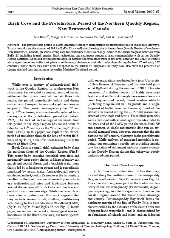
Figure 1. Passamaquoddy Bay and Birch Cove, showing sites and features discussed herein.
Journal of the North Atlantic
S. Blair, M. Horne, A.K. Patton, and W.J. Webb
2017 Special Volume 10
61
sites are within the land trust, BgDs-35 is located on
this privately held strip of land.
History of Field Work in Birch Cove
The Birch Cove area has undergone several
distinct phases of research. Although the Quoddy
Region was the locus of some of the earliest archaeological
research in the Canadian Maritimes
(Matthew 1884; see also Hrynick and Black 2012),
the earliest identification of sites in Birch Cove occurred
with the development of the first systematic
approach to the region in the late 1960s under David
Sanger, then at the Archaeological Survey of Canada
(ASC). Over the course of several years, Sanger
inspected erosional surfaces along many parts of
mainland Passamaquoddy Bay, in some cases systematically
exploring shoreline segments, and in
others, following up on information provided by local
collectors and landowners (D. Sanger, University
of Maine, Orono, ME, USA, pers. comm.). During
this period, Sanger tested and excavated a number of
sites in the area, including Ministers Island (BgDs-
10) and the Carson site (BgDr-5), among others
(Sanger 1987). During this survey, Sanger identified
and explored several sites in and around Birch Cove,
including the three shell-bearing sites, BgDs-14,
BgDs-15, and BgDs-25 (Fig. 1).
In 1970, the New Brunswick government established
a provincial authority, Archaeological Services
New Brunswick (ASNB—later Archaeological
Services). One of the major goals of this new agency
was site inventory and basic site recording and, as a
result, provincially based archaeological teams began
multi-season survey programs across the province,
including in the Quoddy Region (Davis 1978,
1983; Davis and Christianson 1981). The Quoddy
Region surveys resulted in an extensive database
built around the nucleus of information collected
between 1950 and 1970. Due to the comprehensive
goals of these surveys, the primary method of site
identification was the location of eroding shell-bearing
deposits, such that the resulting coastal database
is skewed heavily towards visibly eroding shellbearing
sites (Black 2004, Blair and Black 1993).
Initial surveys focused on mainland Passamaquoddy
Bay, with offshore islands added through time. The
Birch Cove area was revisited in this period, and an
additional site, the shallow shell-bearing site BgDs-
35, was identified.
In 2004, the University of New Brunswick conducted
archaeological research in Birch Cove under
the direction of S. Blair and P. Dickinson, in the
context of an archaeological field school (Blair et
al. 2004, Dickinson et al. 2005). Although the 2004
season included a survey of eroding land margins
and beaches around Birch Cove, and the placement
of a single 50-cm-square test unit in BgDs-25, the
primary focus of the field school was the excavation
of a small portion of BgDs-15 (Dickinson et al.
2005).
BgDs-15 is located on a broad (20–30 m wide)
bedrock bench where pockets of shell-bearing deposits
occur in dry, silty loam immediately above
the undulating surface of the bedrock (Fig. 1).
The site is covered with a thin cap of salt-tolerant
grasses and sedges. The deposits at this site are
typically shallow (between approximately 20 and
50 cm deep above bedrock). The site is adjacent to
a steep shingle beach to the south and west, and it is
actively eroding from both directions. The excavations
at BgDs-15 revealed a small, shallow, shellbearing
deposit containing a rock-lined hearth and
a midden area containing shell and animal bones.
A radiocarbon assay on charcoal from the hearth
returned a historic to modern date (160 ± 30 B.P.,
Beta 376315), which the 2σ calibration places between
cal A.D. 1665 to 1710, or cal A.D. 1720 to
1890, or cal A.D. 1910 to post 1950. However, a
piece of terrestrial mammal bone returned an age
of 1270 ± 30 B.P. (Beta-365483), which the 2σ
calibration places between cal A.D 670 to 780, or
cal A.D. 790 to 800. This latter age places the site
within the LMW period.
During the 2004 field season, the UNB team also
placed a single 50-cm-square test unit in BgDs-25
(Fig. 2). During the inspection of beaches, small,
non-contiguous exposures of shell were observed
on the low area between a marsh and the surrounding
bedrock outcrops along the outer arm of the
northeastern-most point delimited by Birch Cove.
The test unit was placed in the low area immediately
adjacent to the marsh, and ~10 m in from the tree-line
along the edge of the beach. This test unit revealed a
thin layer of Mya arenaria (softshell clam) shells and
a few pieces of Buccinum undatum (northern whelk)
beneath a thin organic debris layer (Dickinson et al.
2005). The shell deposit continued in a homogeneous
layer to ~35–40 cm deep, where it became mixed with
gravel, charcoal flecks, and dark organic soil. Given
time constraints, the test unit was discontinued at ~40
cm below surface, with the intention of returning in
subsequent field seasons. Further fieldwork at this
site occurred in 2015, which is reported below.
In 2014, archaeologists from the provincial Archaeological
Services conducted some minor testing
at BgDs-35 at the behest of the landowner (Jarratt
2015). BgDs-35 consists of a small area of shell and
Journal of the North Atlantic
S. Blair, M. Horne, A.K. Patton, and W.J. Webb
2017 Special Volume 10
62
lithics exposed on the surface near the intersection
of the tree line and the intertidal zone on the western
side of the Sam Orr’s Pond salt marsh, near the
northern margin of Birch Cove (Fig. 1). Exposed
bedrock and large boulders suggest that pockets of
soil containing cultural material and scattered clamshell
mixed with dark brown organic soil are widely
but thinly deposited over the bedrock.
The 2014 testing involved two 50-cm-square
units that were excavated in 10-cm arbitrary levels.
Jarratt (2015:6) describes the site as a “black soil
midden”; within the two 50-cm units, she recovered
bone fragments, lithic artifacts, charcoal, and
fire-cracked rock (Jarratt 2015). Two radiocarbon
assays have been verbally reported, one in the earlier
part of the LMW (ca. 1200 B.P.), and one in the
later portion of the LMW (ca. 700 B.P.; B.D. Suttie,
Archaeological Services, Fredericton, NB, Canada,
pers. comm.). Although no depths were reported in
the 2015 technical report, one of the plates (labeled
“Figure 15”) indicates shallow deposits of shell immediately
under the surface and continuing ~10–20
cm in dark brown soil over large pieces of angular
bedrock (Jarratt 2015:25). The report does not
give details about the presence of possible features
(although these may be suggested by the presence
of fire-cracked rock and charcoal), or the artifacts
themselves. Although the 2014 field testing was
the first subsurface examination of the site, the site
itself is actively eroding, and monitoring efforts
by UNB Anthropology (especially S. Blair and
D.W. Black) have resulted in the recovery of lithic
artifacts consisting of an array of flakes, unifacial
scrapers, a small, broken, side-notched point, and a
few unstemmed bifaces and biface fragments. In all,
this surface-collected assemblage consists of over
450 pieces. Faunal materials were also recovered,
including beaver, deer, and bear. The tool forms
include very small thumbnail scrapers, and small
thin bifacial tools and side-notched points. Taken
together, these attributes support the LMW affiliation
for the site.
Although the analysis of BgDs-35 is ongoing,
some preliminary inferences can be made. The density
of lithic artifacts in both excavation units and
from the eroding portions of the site is significantly
higher than is typical of coastal sites regardless
of age or type. No pottery has yet been recovered.
Figure 2. BgDs-25, showing landscape features and excavation un its.
Journal of the North Atlantic
S. Blair, M. Horne, A.K. Patton, and W.J. Webb
2017 Special Volume 10
63
Although the work at BgDs-35 has been limited,
there have yet to be any architectural or domestic
features recorded, although the presence of firecracked
rock and charcoal suggests a hearth area
remains unexcavated.
The 2015 Birch Cove Archaeology Project
As indicated above, BgDs-25 was first tested
in 2004, and the site was not revisited until 2015,
when the University of New Brunswick, under the
co-direction of S. Blair and M. Horne, collaborated
with a small team from the University of Toronto,
under the direction of A.K. Patton. The site was
selected based on the promising results of the 2004
testing, which seemed to indicate that the site might
contain living floors or dwelling features (Dickinson
et al. 2005, Hrynick et al. 2012). Although the 2004
testing did not produce chronological information,
it was anticipated, based on the number of later
Maritime Woodland sites in the Birch Cove area and
the structure of the deposit observed in the test unit,
that BgDs-25 would contain deposits dating to the
enigmatic later LMW period (between A.D. 1000 to
A.D. 1400; Black 2002). Further, the fact that the
site is on an exposed arm of Birch Cove, facing into
Passamaquoddy Bay, and is actively eroding, added
to the need to recover information from it.
Methodology
During the 2015 field season, 2 areas were
opened, one immediately behind a raised bedrock
area, where softshell clam mixed with dark brown
soil was observed spilling out from the erosional
face, some 50 m west of the marsh margin (Locus
1), and one closer to (within 20 m and west of) the
marshy area (Locus 2; see Fig. 2). A third locus,
containing an historic (and possibly recent) hearth
area was also tested (Locus 3). The 2015 excavations
involved manual excavation in natural layers,
with material screened through 3.2-mm mesh. All
excavations continued to bedrock. The team also
recovered eight 20-cm column samples, as well as
1-L bulk samples from layers within each 50-cm
quadrant of each unit. The analysis of these bulk
samples is ongoing, and will undoubtedly, given the
large numbers of very small bird and fish bones and
the presence of microflakes, influence the final determination
of specimen numbers. In all, two 1 m x
1 m units were excavated in Locus 1, five 1 m x 1 m
units were excavated in Locus 2, and a single 50 cm
x 50 cm unit was opened in Locus 3.
Both Locus 1 and 2 had visible surface deposits
of shell, but these were non-contiguous (i.e.,
there was no shell visible on the surface of the site
between the 2 loci). Other patches of shell to the
north of these areas likely contained further thin
deposits but were also non-contiguous. The 2 units
in Locus 1 produced a comparatively thick layer
of large whole valves of softshell clam mixed with
crushed shells of both softshell clam and, less commonly,
Mytelis edulis (blue mussel) in a brown sandy
loam. These shell deposits began immediately under
the forest litter on the surface of the ground, and occurred
fairly densely in a layer 20–30 cm thick. The
layer also contained a comparatively high number
of northern whelks, and a few very small fish vertebrae,
but no other faunal materials or artifacts, aside
from a single piece of quartz shatter. The analysis of
bulk samples from this locus is ongoing, and these
may reveal a greater focus on very small fish or microdebitage.
Although there were rare fragments of
charcoal, no features were discovered in these units.
This material suggests a highly specialized, limited
activity area, focused on softshell clam and whelk.
The Locus 2 units were opened immediately
adjacent to the placement of the 2004 test excavation.
Like Locus 1 and the 2004 test unit, Locus 2
produced shell immediately under the surface that
continued in a layer ranging from 2–3 cm to 30 cm
thick. Like those in Locus 1, this shell layer was
dominated by softshell clam, but these were more
highly fragmented and mixed with a greasy black
soil and gravel. Unlike Locus 1, Locus 2 was more
structurally differentiated, with rock arrangements,
midden deposits, and areas that are comparatively
shell-free, as described below. Further, Locus 2 also
produced a significant assemblage of lithic artifacts.
Finally, an area 30 m to the north of Locus 2,
designated Locus 3, contained a number of linear
rock arrangements and a single brick-lined hearth
containing a single charred tin can. The entire site
area contains recent washed-in beach debris (such
as fragments of rope, plastic bottles, and plastic-bag
fragments), and it is difficult to determine if the nine
square-cut nails and the fragment of earthenware in
Locus 2 are later intrusions, blown in as flotsam, or
if they represent early European contact. Locus 3,
however, based on the nature of the brick and tin
can, appears to date to fairly late in the historic period,
and may be quite recent. Locus 2 was the only
part of the site excavated in 2015 that produced a
sizeable artifact assemblage, and it will be the focus
of the remainder of this paper.
Results of the 2015 Field Season
The units in Locus 2 were arranged in a crossshaped
pattern, maximizing the area that could be
Journal of the North Atlantic
S. Blair, M. Horne, A.K. Patton, and W.J. Webb
2017 Special Volume 10
64
architectural patterning. The most highly patterned
unit was the northernmost; this unit contained trace
amounts of shell, but notably, the soil in the northeastern
quadrant of the unit was greasy, black, and
contained burnt shell and scattered charcoal, while
the southeast quadrant contained a gravel-free area
of shell and dark soil. Although no formal hearth
area could be identified, the patterns evident in this
unit suggest that such a feature was likely in one of
the immediately adjacent, unexcavated areas. A long
(~40 cm) roughly cylindrical rock was set on end
near the center of this unit such that one tip of it projected
above the surface, while the base of it rested
on bedrock; this position was notably different from
other angular fragments, suggesting that it may have
been emplaced (Fig. 4). Although the tip of the rock
was exposed above the surface of the ground and
weathering made it impossible to determine if any
wear or markings had existed on it, the correlation
of this rock with abundant lithic debris suggests it
may have been related to knapping, perhaps as some
kind of anvil stone. As indicated in Figure 5, this
area produced the largest volume of lithics, including
a roughly finished, thick, oval biface, two wellthinned
biface tip fragments (Fig. 6), and a number
flakes with battered or worn edges suggestive of
use (Fig. 7). An additional thick, oval utilized flake
was recovered from the northwest quadrant of the
westernmost unit. Interestingly, the assemblage did
not contain any endscrapers or side scrapers, which
many consider to be a ubiquitous Woodland period
tool class (Davis 1978, Sanger 1987).
The assemblage is overwhelmingly dominated
by a medium-grained, dark reddish-brown porphyritic
volcanic material. Quartz and fine-grained
bleached materials (either fine-grained volcanics
or cherts) form minority materials (less than 5%).
Although this material cannot be associated with the
bedrock at or near the site, it is similar to rocks of
volcanic origin that outcrop in the Quoddy Region.
opened while retaining extensive profiles (Figs. 2,
3). Deposits in Locus 2, like those in Locus 1, were
dominated by softshell clam mixed with occasional
mussel fragments, as well as a large number of large,
typically whole northern whelks. The composition
of the shellfish assemblage is similar to that in
other LMW assemblages in Birch Cove (as outlined
above), but different from that typical of sites dating
to the Middle Maritime Woodland and the earlier
part of the LMW, where species such as green urchin
(Strongylocentrotus droebachiensis), blue mussel,
horse mussel (Modiolus modiolus), and various
whelks and winkles represent significant minority
components (Black 2002, 2004). However, the
northern whelks recovered from both Locus 1 and 2
are notable for their high numbers; these occurred in
the hundreds and were represented by a number of
size classes.
The excavation areas revealed considerable
patterning in these deposits (see Fig. 4); the southernmost
and easternmost units produced deposits
of shellfish remains (Mya sp. and Buccinum sp.)
ranging from 2 to 30 cm thick, with thin deposits
of shell being mixed with gravel in the westernmost
and northernmost units, and shell deposits becoming
both denser and thicker towards the southeast.
On the other hand, thick deposits of shell were
inversely correlated with artifacts, with the southern
and eastern units producing comparatively few
lithic artifacts, and the central and (in particular)
the northern unit producing more (see Fig. 5). The
bedrock underlying the site was angular and fragmented,
and slabs of rock and shattered rubble were
integrated into the matrix in all units; however, these
angular rock slabs, which ranged in size between 10
and 30 cm in length occurred in large numbers in the
north half of the central unit, and the northern unit
(Fig. 4). Some of these slabs might be arranged as a
part of a living surface, but the ubiquity of rock in
the site area complicated our ability to identify any
Figure 3. North profile of the central units of locus 2, BgDs-25 .
Journal of the North Atlantic
S. Blair, M. Horne, A.K. Patton, and W.J. Webb
2017 Special Volume 10
65
that the site is either protohistoric or early historic
(as discussed below) requires us to consider that
these may be artifacts that are contemporary with
the other artifacts and materials reported above from
Locus 2. The nails are highly corroded, and the nail
heads have not survived in a state that they can be
examined; as a result, we cannot say more than that
they date to post-European contact and prior to the
20th century. The buff-colored ceramic sherd is also
European or Euro-American in origin; it consists of
an unglazed, exterior surface on a fragment less than
10 mm in maximum dimension. The body has large
white inclusions, and it may be that this is a ware
typical of colonial French sites (Fig. 8). This ware is
Grit- or shell-tempered, low-fired pottery was also
absent from the site. In addition to shell, the site
also produced several large fish vertebrae, hundreds
of tiny fish vertebrae (comparable in size to those
from the assemblage from BgDs-15), and a number
of avian long bones and phalanges. Many of the tiny
fish bones and bird phalanges were concentrated in
the northern half of the northernmost unit.
Given the shallowness of the deposits at BgDs-
25, and the visible evidence of recent debris being
blown onto the site surface, we assumed that
the historic artifacts encountered in Locus 2 (nine
square-cut nails and one fragment of buff-colored
earthenware) were intrusive. However, the inference
Figure 4. Distribution of rocks and layers in Locus 2, BgDs-25.
Journal of the North Atlantic
S. Blair, M. Horne, A.K. Patton, and W.J. Webb
2017 Special Volume 10
66
present in the assemblage from the nearby
Saint Croix Island (located in Saint Croix
river, north of St. Andrews; Fig. 1), which
was occupied in 1604–1605 by an expedition
led by Pierre Dugua, Sieur de Mons
(Mock 2006). These wares consisted of 2
types: one an unglazed variant with a buffcolored
body, and one with a green glaze
and a yellowish paste (Mock 2006:36); the
fragmentary sherd from BgDs-25 may be
similar to the first variant.
A single fragment of cut terrestrial
mammal (ungulate) bone was recovered.
This was subsequently submitted for a
radiometric assay, and returned a date of
270 ± 30 B.P. (Beta-422062). The 2σ calibration
places it sometime during cal A.D.
1520—1575 or cal A.D. 1630–1665 or cal
A.D. 1785—1795. Similar to other terrestrial
mammal bone dates from the Quoddy
Region, the sample was depleted for δC13
(-24.3‰), which may reflect heating of
the bone. This result suggests a protohis-
Figure 5. Piece count of Lithic artifacts (tools and debris) by unit and toric or historic age for the assemblage.
quadrant, Locus 2, BgDs-25.
Figure 6. Oval biface and biface tip fragments from the norther nmost region of Locus 2, BgDs-25.
Journal of the North Atlantic
S. Blair, M. Horne, A.K. Patton, and W.J. Webb
2017 Special Volume 10
67
overwhelmingly local nature of the lithic materials,
and the composition of the shellfish assemblage.
Given these factors, we suggest that the radiometric
assay correctly indicates the age of the site, and
based on the lack of artifacts that would be typical
of later-17th- or 18th-century sites, we place it in the
century immediately before direct contact in the
form of early 17th-century French exploration and
settlement.
Discussion and Conclusion
The latest part of the LMW, including the
protohistoric and early contact periods, has long
been enigmatic; in comparison to the thick, highly
visible shell-bearing sites of the middle part of the
Maritime Woodland, the shallow, often ephemeral
components that appear to be typical of the LMW
are poor in material culture, difficult to date, and
difficult to compare with both earlier and later
components, and with other sites on the landscape.
Moreover, the first written accounts of European
contact with indigenous peoples in the Northeast
are often fragmentary and lacking in detailed descriptions
(Trigger 1985:111, 121). These sources
show that by the 1520s, Portuguese were fishing
off the coast of Nova Scotia and central Maine,
although the extent and nature of trade between
Europeans and indigenous groups differed from
place to place (Brasser 1978, Trigger 1985:128).
European ships were likely infrequent visitors in
Nova Scotia waters in the early 16th century, but
nonetheless, Cartier encountered indigenous peoples
eager and well accustomed to trading furs for
European goods, while foreigners were less well
received in Maine (Trigger 1985:127–130).
Both responses suggest that there may have
been even earlier encounters with Europeans,
but in central Maine, there were few interactions
between local groups and foreign fishers
and whalers during the remainder of the
16th century (Bourque 2001:114–115, Trigger
1985:127–130). Mi’kmaq living in Nova Scotia
and eastern New Brunswick at this time,
however, became regional middlemen and
largely controlled trade between Europeans
and indigenous groups living in the Gulf of
Maine (Bourque and Whitehead 1985, Petersen
et al. 2004:59). In fact, archaeological
research in the area reveals that indigenous
peoples throughout the Maine–Maritimes
region, including Passamaquoddies, had
incorporated European goods such as copper
kettles, glass beads, and iron axes into social,
economic and ideological spheres of their
In some ways, this age may be consistent with the
assemblage. Although the site is structurally similar
to single-component LMW sites in both Birch Cove
and the Quoddy Region (see Black 2004, Dickinson
et al. 2005, Hrynick et al. 2015, Jarratt 2015, Sanger
1987), it is also different from earlier LMW sites in
the absence of pottery or scrapers at BgDs-25, the
Figure 8. Unglazed, buff-colored colonial ceramic sherd from Locus
2, BgDs-25.
Figure 7. Example of flake with battered or worn edges
indicative of use from the northernmost region of Locus
2, BgDs-25.
Journal of the North Atlantic
S. Blair, M. Horne, A.K. Patton, and W.J. Webb
2017 Special Volume 10
68
like BgDs-35 and BgDs-15) to a more exposed location
on the outer arms of the Cove (like BgDs-25)
may, like the settlement at Devil’s Head, reflect
a desire to observe and monitor conditions in the
larger bay. Given that this was a century when new
visitors were beginning to appear in coastal areas
around the Quoddy Region, this position may also
reflect a desire to monitor boat traffic. All of these
subtle patterns warrant consideration as we finally
turn our archaeological gaze to the transformation
of Passamaquoddy lifeways in the critical decades
around contact.
Acknowledgements
We thank the Schoodic Band of Passamaquoddy, Chief
Hugh Akagi, and the Nature Trust of New Brunswick for
granting us permission to excavate BgDs-25. Funding
and support for this project was generously provided by
the Archaeology Centre at the University of Toronto, the
University of New Brunswick, and Sheila Washburn. We
are grateful to the anonymous reviewers who provided
insightful comments on this paper. We greatly appreciate
our 2015 field crew—Ellie Tamura, Lisa Small, Chiara Williamson,
and Matthew Reijerkerk—and also Lloyd Waugh
(Department of Civil Engineering, UNB) for recording the
site through high resolution photography.
Literature Cited
Black, D.W. 1993. What Images Return: A Study of the
Stratigraphy and Seasonality of a Shell Midden in the
Insular Quoddy Region, New Brunswick. New Brunswick
Archaeology 27, The Partridge Island Archaeology
Project, Volume 1. Municipalities, Culture, and
Housing, Fredericton, NB, Canada. 132 pp.
Black, D.W. 2002 Out of the blue and Into the black:
The Middle-Late Maritime Woodland Transition in
the Quoddy Region, New Brunswick, Canada. Pp.
109–122, In J.P. Hart and C.B. Rieth (Eds.). Northeast
Subsistence-Settlement Change A.D. 700–1300. New
York State Museum Bulletin 496, Albany, NY, USA.
359 pp.
Black, D.W. 2004. Living Close to the Ledge: Prehistoric
Human Ecology of the Bliss Islands, Quoddy Region,
New Brunswick, Canada. 2nd Edition. Occasional Publications
in Northeastern Archaeology No. 6, Copetown
Press, St. John’s, NL, Canada.
Blair, C.R., and D.W. Black. 1993. The Northeast Point
site: A single-component occupation without middens
on the Bliss Islands. Paper presented at the 24th annual
meeting of the Canadian Archaeological Association,
St. John’s, NL, Canada. Manuscript on file at University
of New Brunswick, Department of Anthropology,
Fredricton, NB, Canada.
Blair, S., P. Dickinson, D. Black, and B. Broster. 2004.
The geoarchaeology of a coastal fish trap in southern
New Brunswick. Poster presented at the Eastern States
Archaeology Federation conference, Midland, ON,
Canada.
lives by the mid-to-late 16th-century (Cox 2000,
Fitzgerald et al. 1993, Petersen et al. 2004).
Much of the literature on the protohistoric period
has pointed to disjunctures in lifeways and material
culture that occurred around the time of contact
(Bourque and Whitehead 1985, Prins 1992, Whitehead
1993). Our analysis suggests that these real disjunctures,
wrought by war and disease, were woven
together with complex continuities in landscape use
and settlement. The material discussed above allows
us to draw several inferences and make a number
of speculations about BgDs-25 and protohistoric
settlement in Birch Cove. First, the assemblage described
above represents a strong case for continuity
into the protohistoric era, with elements of LMW
technology and economy persisting to up to decades
around contact, a pattern noted by archaeologists
working on contact-period sites in adjacent regions
in Maine (Cox 2000, Hrynick et al. 2015, Petersen et
al. 2004). For example, Hrynick et al. (2015) report
on the Devil’s Head Site (97.10), a small, multicomponent
site on the Maine side of the Quoddy Region.
This site produced a radiometric date that overlaps
with the one produced at BgDs-25 (390 ± 50 B.P.,
AA-10697), with a cal A.D. 2σ range of 1432 to
1635. Further, Hrynick et al. (2015:60) comment on
the “relative dearth of scrapers and the abundance
of bifaces” in particular components of the Devil’s
Head assemblage, which looks very much like the
lithic assemblage at BgDs-25 and other LMW sites.
Like BgDs-25, Devil’s Head exhibited a high degree
of intrasite patterning, including large rock arrangements
that are interpreted as being parts of dwelling
features. These sites then, exhibit common elements
and strong continuity across the pre-contact/contact
period. There can be no doubt that ancestral Passamaquoddy
people lived at Birch Cove and continued
lifeways that extended back into the deeper reaches
of prehistory.
Second, as new information emerges, it is clear
that protohistoric settlement and subsistence requires
close examination. BgDs-25 and other sites
in Birch Cove appear to be part of a shift from large,
multicomponent Middle and early LMW sites in
key, repeatedly occupied locations towards shallow,
more ephemeral sites in new locations. While
bifaces continued to be a focus of lithic production,
it appears the standardized and formally styled
endscrapers that were so typical of earlier periods
were being replaced by more expediently produced
utilized-flake technologies. While subsistence continued
to be underpinned by softshell clam exploitation,
fishing, and bird hunting, whelks appear to
have been important secondary resources. Finally,
the shift from settlement within Birch Cove (at sites
Journal of the North Atlantic
S. Blair, M. Horne, A.K. Patton, and W.J. Webb
2017 Special Volume 10
69
Bourque, B.J. 2001. Twelve Thousand Years: American
Indians in Maine. University of Nebraska Press, Lincoln,
NE, USA. 368 pp.
Bourque, B.J., and R.H. Whitehead. 1985. Tarrentines and
the introduction of European trade goods in the Gulf of
Maine. Ethnohistory 34(4):327–341.
Brasser, T. J. 1978. Earlier Indian–European contacts.
Pp. 78–88, In B.G.Trigger (Ed.). Handbook of North
American Indians. Volume 15: Northeast. Smithsonian
Institution Press, Washington, DC, USA.
Carriker, M.R. 1959. The role of physical and biological
factors in the culture of Crassostrea and Mercenaria in
a saltwater pond. Ecological Monographs 29:219–266.
Cox, S.L. 2000. An early contact native site on the upper
St. Croix River. The Maine Archeological Society Bulletin
40:2:1–10.
Davis, S.A. 1978. Teacher’s Cove: A prehistoric site on
Passamaquoddy Bay. New Brunswick Archaeology
Society Series #1. Historical Resources Administration,
Fredericton, NB, Canada. 64 Pp.
Davis, S.A. 1983. Rising sea levels threaten archaeological
sites. Canadian Geographical Journal 103(2):40–46.
Davis, S.A., and D. Christianson. 1981. Archaeological
resources in the Maritimes: A coastal survey, 1979.
Historical Resources Administration, Archaeology
Branch, Fredericton, NB, Canada. 97 pp.
Dickinson, P., and B. Broster. 2007. Landscape modification
and aboriginal utilization of coastal tidal ponds:
An example from southwestern New Brunswick,
Canada. Pp. 109–124, In L. Wilson, P. Dickinson, and
J. Jeandron (Eds.). Cambridge Scholars Publishing,
Cambridge, UK.
Dickinson, P., S. Blair, and D. Black. 2005. Technical
report on the 2004 University of New Brunswick Archaeological
Field School, License number 2004 NB7.
Ms on File, Archaeological Services New Brunswick.
NB Department of Culture, Wellness, and Sport, Fredericton,
NB, Canada.
Dillon, R., and J. Manzi. 1992. Population genetics of the
hard clam, Mercenaria mercenaria, at the northern
limit of its range. Canadian Journal of Fisheries and
Aquatic Sciences 49:2574–2578.
Fitzgeral, W., L. Turgeon, R.H. Whitehead, and J.W.
Bradley. 1993. Late sixteenth-century Basque banded
copper ketles. Historical Archaeology 27(1):44–57.
Hrynick, M.G., and D.W. Black. 2012. Bocabec Archaeological
Site. The Canadian Encyclopedia. Available
online at http://www.thecanadianencyclopedia.com/
articles/bocabec-archaeological-site). Accessed 10
May 2016.
Hrynick, M.G., M.W. Betts, and D.W. Black. 2012. A
Late Maritime Woodland period dwelling feature from
Nova Scotia’s South Shore: Evidence for patterned
use of domestic space. Archaeology of Eastern North
America 40:1–25.
Hrynick, M.G., W.J. Webb, D. Leslie, T. Testa, J.A. Fable,
and W.A. Farley. 2015. 2014 archaeological investigations
at the Devil’s Head Site (97.10), Washington
County, Maine. Report on file, Maine Historic Preservation
Commission, Augusta, ME, USA.
Jarratt, T.J. 2015. Preliminary technical report, BgDs-
35: Sam Orr’s Pond evaluative testing and recovery.
Manuscript on file, Archaeological Services, Heritage
Branch, Department of Tourism, Heritage, and Culture.
Fredericton, NB, Canada.
Matthew, G.F. 1884. Discoveries of at village of the Stone
Age at Bocabec. Bulletin of Natural History of New
Brunswick 3(2):6–29.
Medcof, J.C., A.H. Clarke, and J.S. Erskine. 1965. Ancient
Canadian east-coast oyster and quahog shells.
Journal of Fisheries Research Board of Canada
22(2):631–634.
Mock, K. 2006. An analysis of the morphological variability
between French ceramics from 17th-century
archaeological sites in New France. M.A. Thesis.
Department of History, University of Maine, Orono,
ME, USA.
Petersen, J.B., M. Blustain, and J.W. Bradley. 2004. “Mawooshen”
revisited: Two Native American contact
sites on the central Maine coast. Archeology of Eastern
North America 32:1–71.
Prins, H. 1992. Cornfields at Meductic: Ethnic and territorial
reconfigurations in colonial Acadia. Man in the
Northeast 44:55–72.
Sanger, D. 1987 The Carson Site and the late Ceramic Period
in Passamaquoddy Bay, New Brunswick. Archaeological
Survey of Canada Paper No. 135, National
Museum of Canada, Ottawa, ON, Canada. 157 pp.
Sanger, D. 1988. Maritime adaptations in the Gulf of
Maine. Archaeology of Eastern North America
16:81–99.
Thomas, M.L. (Ed.). 1983. Marine and Coastal Systems
of the Quoddy Region, New Brunswick. Canadian
Special Publication of Fisheries and Aquatic Sciences
64. Department of Fisheries and Ocean, Ottawa, ON,
Canada. 306 pp.
Tracy, E.J., and G.R. South. 1989. Composition and seasonality
of micro-algal mats on a salt marsh in New
Brunswick, Canada. British Phycological Journal
24(3):285–291
Trigger, B. G. 1985. Natives and Newcomers: Canada’s
“Heroic Age” Reconsidered. McGill-Queens University
Press, Kingston, ON, Canada. 430 pp.
Turnbull, C.J. 1984. The Richibucto burial site (CdDf:18),
New Brunswick research in 1981. Manuscripts in
New Brunswick Archaeology, No. 2, NB Cultural and
Historical Resources Administration, Fredericton, NB,
Canada. 29 pp.
Whitehead, R.H. 1993. The Protohistoric Period in the
Maritime Provinces. Pp. 227–258, In M. Deal and S.
Blair (Eds.). Prehistoric Archaeology in the Maritime
Provinces: Past and Present Research. Reports in
Archaeology No. 8, Council of Maritime Premiers,
Fredericton, NB, Canada. 330 pp.