2010 SOUTHEASTERN NATURALIST 9(3):487–496
Spatial Distribution of Alligator Holes in the
Central Everglades
Laura A. Brandt1,*, Mark R. Campbell2,3, and Frank J. Mazzotti2
Abstract - Alligator holes are a key feature of Everglades marshes that provide refugia
and foraging sites for a wide range of species. We investigated the spatial pattern
of alligator holes in Water Conservation Area 3, a part of the central Everglades, and
examined associations among alligator holes, canals, and hydrology. There were
fewer alligator holes within 1000 m of canals than expected, supporting the hypothesis
that Alligator mississippiensis (American Alligator) are using canals as aquatic
refugia rather than creating or maintaining alligator holes in the marsh. In addition,
density of holes was associated with hydrology; specifically, areas that were drier
had more than twice as many alligator holes than areas that were wetter. Analyses
from this study provide a baseline for evaluating changes in location and density of
alligator holes in response to canal removal and hydrologic changes that will occur
as part of Everglades restoration.
Introduction
Alligator mississippiensis Daudin (American Alligator) is a keystone
species in the Everglades and other marsh systems, acting as both predator
and prey and helping to maintain topographic and ecologic diversity. Alligators
contribute to both animal (Kushlan 1974) and plant (Campbell and
Mazzotti 2004, Palmer and Mazzotti 2004) richness and diversity through
construction and maintenance of alligator holes. Alligator holes are depressions
in the marsh maintained by alligators that hold water when the marsh
surface has gone dry. In this paper, we are referring only to areas that have
a visible pond, and not to underground “dens” or “caves” that also may hold
water. Alligator holes are maintained by Alligators pulling up loose plants,
sweeping soil with their tails, and pushing and carrying it to the pond perimeter
(Craighead 1968, McIlhenny 1987). Alligator holes range in size and
shape and can be as small as a few meters in diameter or as large as several
hectares. They provide both refugia and foraging areas for Alligators and
other wildlife during the dry season. In addition, edges can provide localized
topographic highs conducive for plant colonization. Alligator activity
is what distinguishes alligator holes from other depressions in the marsh
which may serve as refugia or foraging areas (Campbell and Mazzotti 2004,
Kushlan 1974).
1US Fish and Wildlife Service, 3205 College Avenue, Davie, fl33332. 2University
of Florida, Fort Lauderdale Research and Education Center, 3205 College Avenue
Davie, fl33332. 3Current address - Broward County Highway Construction and
Engineering Division, 1 North University Drive, Suite 300, Plantation, fl33324.
*Corresponding author - laura_brandt@fws.gov.
488 Southeastern Naturalist Vol. 9, No. 3
Kushlan and Hunt (1979) classified alligator holes into three types
based on their location and underlying physical attributes: large, deep alligator
holes found in limestone depressions in cypress swamps; smaller,
shallower alligator holes found in the rocky glades and marl prairies of
Everglades National Park; and variable sized alligator holes formed in peat
depressions throughout ridge and slough wetlands in the north and central
Everglades. This third type of alligator hole may be formed by lightning
strikes, peat fires, peat pop-ups, or Alligators digging in the peat. Peat alligator
holes do not correspond to underlying depressions in the limestone
bedrock, and Campbell and Mazzotti (2004) hypothesized that spatial patterns
of this type of alligator hole would reflect local habitat conditions.
Alligators also use human-created depressions termed man-made holes
(Campbell and Mazzotti 2004).
Both Craighead (1968) and Kushlan (1974) stated that a decline in Alligators
in portions of the Everglades has resulted in the loss of alligator holes
and consequently refugia and foraging areas for Alligators and other wildlife.
They identified increased drainage and construction of canals as factors
contributing to the decline of Alligators and reduction in number of active
alligator holes. Alligators require some deep water for thermal regulation
and breeding (Lang 1977) and will move out of areas that are too shallow
for too long (hydroperiod < 9 months). On the other hand, Alligators may
have reduced growth rates and lower body condition in marshes that are too
wet (minimum monthly average water depth > 0.91 m; Rice et al. 2004). In
areas near canals, the deeper water habitat in the canal mimics the role of
alligator holes and serves a function similar to creeks in the estuarine fringe
(Craighead 1968). In many places, large Alligators (particularly males) have
moved into canals and no longer maintain or construct alligator holes in the
marsh (Percival et al. 2000), presumably because access to the deep-water
canal habitat replaces the need to maintain a hole. A hypothesized consequence
of reduced alligator distribution resulting from Alligators moving to
canals and out of drier areas is reduction in number of active alligator holes.
In turn, a reduction in number of alligator holes is hypothesized to alter
abundance and diversity of flora and aquatic fauna and hence the functioning
of the marsh ecosystem.
A major part of Everglades restoration is the Comprehensive Everglades
Restoration Plan (CERP), which focuses on improving hydrologic conditions
to restore ecologic functions (US Army Corps of Engineers and South Florida
Water Management District 1999). Within the CERP, there are a number of
components that will result in changes in marsh hydrology through changes
in amounts and locations of water inflows to the water conservation areas
and Everglades National Park. Some of these changes will occur through
removal or partial removal of canals and levees, including the Miami and
L-67 canals in Water Conservation Area 3 (WCA 3). These removals have
the potential to change ecological dynamics of adjacent marshes. Alligators
displaced from canals are expected to move into adjacent marshes and create
2010 L.A. Brandt, M.R. Campbell, and F.J. Mazzotti 489
and maintain more alligator holes (especially close to where canals had been
located); this change will result in greater habitat heterogeneity and overall
marsh productivity. In addition, as marsh hydrologic conditions improve, it
is expected that distribution and number of Alligators will increase, which
in turn should result in an increase in the distribution and number of alligator
holes. It also is expected that as the number of adult Alligators in the
marsh increases, through natural recruitment or displacement from canals,
more adult Alligators will be observed in alligator holes. Campbell (1999)
observed Alligators of all size classes in alligator holes; however, most of
his observations were of juveniles and hatchlings with an associated adult
presumed to be female.
In this paper, we provide a descriptive analysis of spatial patterns of
alligator holes in WCA 3 and use those data to examine linkages among
locations of natural alligator holes, canals, and hydrology. We specifically
examine linkages between proximity of canals and natural alligator hole
density, with the expectation that there would be fewer holes near canals, and
associations of hydrology and alligator hole density, with the expectation
that there would be a higher density of holes in drier areas than in wetter areas.
Analyses from this study will provide a baseline for evaluating changes
in location and density of alligator holes in response to canal removal and
hydrologic changes that will occur as part of Everglades restoration.
Methods
Study area
This study was conducted within WCA 3 in the central Everglades
(Fig. 1). WCA 3 is a 2442-km2 area surrounded by a series of levees and
canals (northwest corner at N26.34, W80.84; southeast corner at N25.76,
W80.46). It is the largest of the impounded areas created by the US Army
Corps of Engineers for flood protection and water supply (David 1996, Light
and Dineen 1994). WCA 3 functions as a water storage, water supply, flood
control, and wildlife management area. Soils in WCA 3 are organic peat
soils overlying limestone bedrock. Soil depth ranges from 0.15 m to 1.30 m
(Shortemeyer 1980). Hydrology varies from north to south, with longest hydroperiods
(period of inundation) in the south along the levees and shortest
hydroperiods in the north. Historically, all of WCA 3 was flooded an average
of 10 months of the year. Presently, levees located immediately to the
north and west reduce water inflow and sometimes limit inundation to six
months per year. Mean marsh surface water depths fluctuate from 0 m to
approximately 1.30 m deep toward the end of the summer wet season. The
dominant wetland habitat is seasonally flooded Cladium jamaicensis Crantz
(Sawgrass) marsh. The area is dotted with numerous small tree islands, both
natural and manmade. Annual precipitation is 1.45 m, of which 82% falls
during the summer wet season (Schomer and Drew 1982). Mean monthly
temperature ranges from 18.9 °C in January to 27.8 °C in August (Schomer
and Drew 1982).
490 Southeastern Naturalist Vol. 9, No. 3
Data sources and analysis
Alligator hole data were obtained from an alligator hole map of WCA 3
produced from September 1994 color infrared aerial photography (Campbell
and Mazzotti 2001). In that study, a combination of field work and photo-interpretation
were used to map alligator holes. Potential alligator holes were
identified on photography as small, dark, open-water areas greater than 5 m
in diameter with a round or oval boundary indicating a vegetation change.
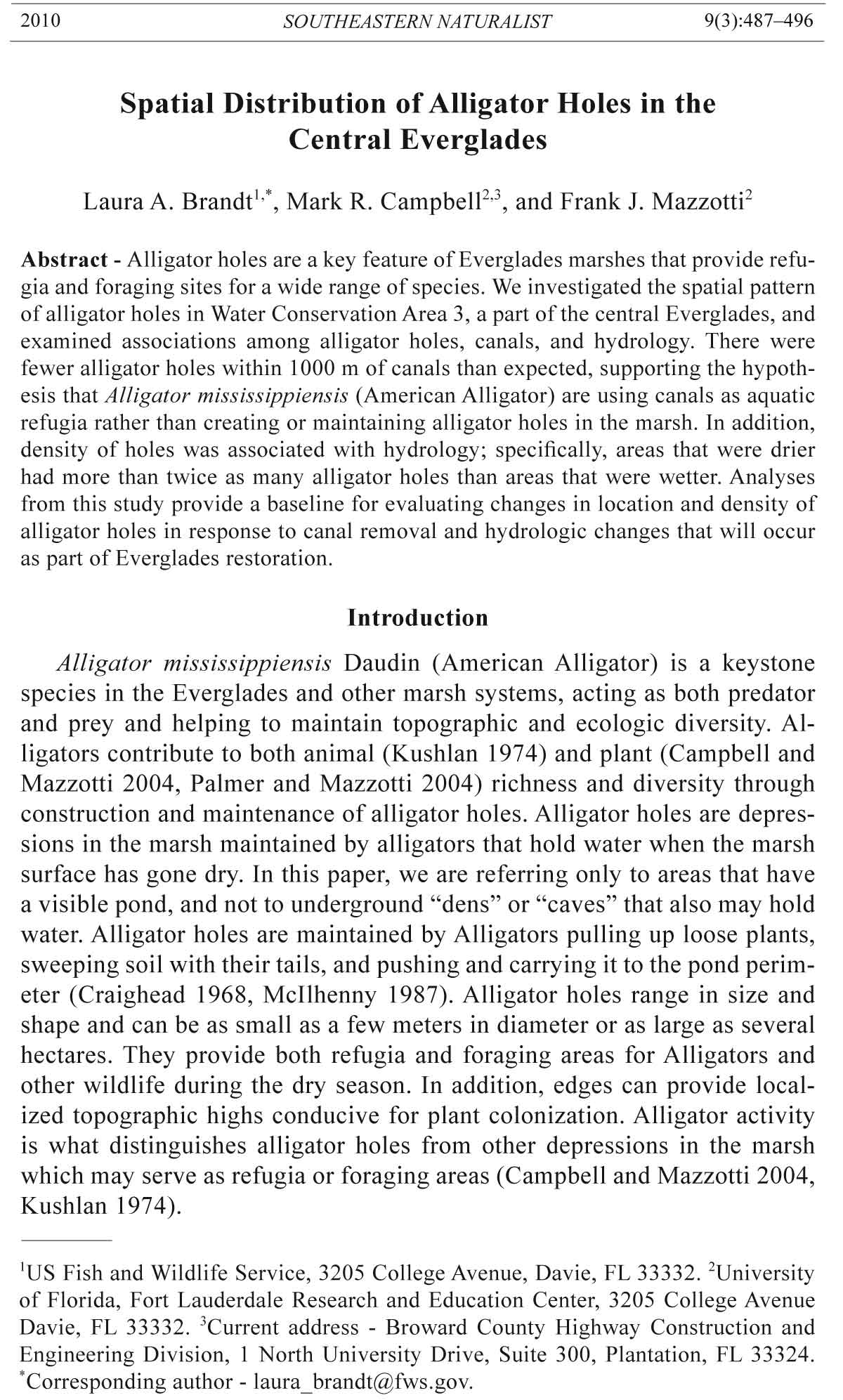
Figure 1. Location of study area (shaded) in South Florida and number of natural
alligator holes in each 3.2-km x 3.2-km grid cell of the South Florida Water Management
District water management model.
2010 L.A. Brandt, M.R. Campbell, and F.J. Mazzotti 491
Ten percent of the potential alligator holes were ground-truthed to evaluate
errors of commission. In addition, Alligator activity (presence of Alligators,
trails, nests, or scat) was assessed at 29 holes (3.5% of 819) in spring and
fall. One hundred percent of the visited holes had evidence of Alligator use
at some time of the year, though use was variable by season (Campbell and
Mazzotti 2004; M.R. Campbell, unpubl. data).
We used the 819 point locations of alligator holes identified on the final
map. Alligator holes were either natural (n = 620) or man-made (n = 199).
Man-made holes were associated with spoil banks, which were constructed
in the 1970s (for the benefit of deer in times of extremely high water) by
digging muck with a drag line and piling it adjacent to the hole. Distances
to nearest neighboring holes were calculated for all holes and within and
between the two types of holes (natural and man-made). Ripley’s K (Ripley
1981) was used to examine the spatial pattern of natural alligator holes.
Information on canal locations was obtained from the South Florida Water
Management District (SFWMD). Distance from nearest canal was calculated
for each alligator hole. A chi-square analysis was used to determine if there
were proportionally fewer natural alligator holes closer to canals than in the
rest of the marsh. This relationship was analyzed for the entire study area using
1000-m increments and within 1000 m of the canal using 100-m increments.
Hydrology data were obtained from the SFWMD Water Management
Model (WMM) V 3.5 validation run for January 1991–September 1994. This
model, developed to simulate hydrology of the water management system in
southern Florida (MacVicar et al. 1984), has been used in restoration planning.
The results from the validation run were the current best estimate of
actual hydrological conditions in the modeled area at the time of this study.
The period covered included the three dry seasons prior to when the alligator
holes were mapped. Since Alligators are most likely to create new holes in
the dry season, and alligator holes without Alligators may fill in over a period
of one to three years (Kushlan 1974), this three-year time frame seemed
reasonable for assessing the association of alligator hole location and hydrology.
Grid cell size for the WMM is 3.2 x 3.2 km (2 × 2 mi). Temporal
resolution of the data used in this analysis was one week. Values obtained
were weekly average water depths (feet) in each cell from 1 January 1991
through 30 September 1994.
Hydrology data were summarized using the following three variables:
average hydroperiod (number of months each year when water depth was
above 0), average number of weeks each year when average weekly depth
was equal to or below 0 (below ground), and average yearly wet season water
depth. Based on relevance of these variables to Alligators, each cell was categorized
as either “too dry” (hydroperiod < 9 months), “dry” (hydroperiod > 9
months, but either with average wet -season depth ≤ 0.31 m [1 ft] or with four
or more weeks with average water depth < 0), “wet” (hydroperiod > 9 months,
average wet season water depth > 0.31 m, and fewer then four weeks where average
water depth was < 0), or “too wet” (hydroperiod > 9 months and average
492 Southeastern Naturalist Vol. 9, No. 3
yearly wet-season water depth > 1.22 m [4 ft]). There were no cells that were
“too dry” or “too wet” based on these criteria. Twenty-eight cells were “dry”,
and 192 were “wet”. Number of natural alligator holes was compared between
the “dry” and “wet” groups using a Wilcoxon rank sum test.
Stepwise regression was used to investigate how the number of man-made
holes, hydrologic variables, and location (expressed as X and Y coordinates
representing the center of each cell) were associated with the number of natural
holes. Variables that were not normally distributed were log transformed
(natural log) prior to analysis. Means and medians are expressed as ± standard
deviation. All analyses were performed in S-Plus (Mathsoft 1996).
Results
Nearest neighbor distance between alligator holes of all types ranged
from 108 m to 4288 m (mean = 654 ± 567 m). Nearest neighbor distance
between only natural holes ranged from 108 m to 4404 m with an average of
793 ± 693 m (n = 640). Nearest neighbor distance between only man-made
holes ranged from 130 m to 1284 m (mean = 304 ± 135 m). Mean and median
nearest neighbor distances were significantly different between man-made
holes (304 ± 135 m and 272 m, respectively) and natural holes (793 ± 693 m
and 622 m, respectively; χ2 = 168.9, d.f. = 2, P < 0.001), with man-made
holes being closer together than natural holes.
Ripley’s K analysis indicated that distribution of natural holes follows
an inhomogeneous poisson process. This kind of pattern is observed when
there is an underlying density gradient or a strong trend in one direction.
The plot of number of natural holes per hydrologic grid cell supports this
result (Fig. 1), with the general pattern of more holes in the north than in
the south.
Average distance from a canal to a natural hole was 3959 ± 3049 m
(range = 0.4–13732 m, n = 640). There were fewer natural holes within 1000 m
of canals (98) than expected (148) based on proportion of area (23% of the
study area) within 1000 m of canals (χ2 = 28.98, d.f. = 12, P < 0.001). Within
1000 m adjacent to canals, alligator holes were distributed in 100-m bands as
one would expect if holes were distributed in proportion to available area.
The number of weeks each year of dryness (average weekly depth ≤ 0)
and the average wet-season water depth varied throughout the study area.
Average number of dry weeks ranged from 0 to 13, with an average of 0.91
± 2.29 and a median of 0 (n = 220). Average wet-season depth ranged from
0.13 to 1.19 m, with an average of 0.63 ± 0.26 m. There were significantly
more natural holes in areas that were categorized as “dry” compared to
those categorized as “wet” (mean of 5.46 ± 5.40 compared to 2.43 ± 2.62;
z = 2.5098, P = 0.0006). The best model resulting from stepwise regression
analysis included wet-season depth and location (both X and Y) and explained
13% of the observed variation (F = 10.91, d.f. = 3, 216, P < 0.001);
ln(number of natural holes) = 0.3342 + 0.2339(ln[average wet-season
depth]) + 0.0526[row] + [-0.053][column]).
2010 L.A. Brandt, M.R. Campbell, and F.J. Mazzotti 493
Discussion
Alligator holes were associated with environmental attributes including
distance from canal, hydrology, and location within the study area. There
were proportionally fewer alligator holes within 1000 m of canals than expected
if alligator holes were distributed based on area alone. The existence of
relatively fewer alligator holes near canals suggests that Alligators are substituting
these artificial deep-water habitats for naturally created alligator holes.
Prior to canal construction, within the ridge and slough landscape, the deeper
standing water required by Alligators was found in deeper sloughs, natural
depressions, and alligator holes. Adult Alligators in canals do not need these
natural deep water areas; they rarely move more than 1000 m into the marsh
and do not occupy or maintain alligator holes (Percival et al. 2000).
This pattern of alligator hole distribution is consistent with those reported
by Craighead (1968) and Kushlan (1974), who suggested that in some
places canals serve as primary refugia for Alligators, thus alleviating the
need for nearby alligator holes. Historically, in other parts of the system, rivers
and streams served as deep-water areas used for courtship, breeding, and
thermal refugia. The spatial pattern of alligator holes identified in this study
has consequences for Alligators as well as for the richness and diversity of
aquatic fauna and marsh vascular plant species. Although canals may be suitable
for adult Alligators, they are not suitable for hatchlings or juveniles who
require social refugia (Campbell and Mazzotti 2004, Chopp 2003). Chopp
(2003) documented lower production of young from nests along canals as
well as lower first-year survival of those hatchlings produced. In addition,
size distribution of animals in canals are skewed toward adults (L.A. Brandt,
pers. observation), indicating that juveniles are not successfully occupying
this habitat. In contrast, Campbell and Mazzotti (2004) found Alligators of
all size classes in alligator holes.
Canals may not provide suitable foraging habitat for wading birds, as
their sides are often steep with no place for the birds to forage. This lack
of slope also means canals do not provide suitable nursery habitat for many
fish. Alligator holes, and other deeper open-water habitats, provide habitat
for fish such as Lepisosteus platyrhincus Dekay (Florida Gar), Ictalurus
natalis Lesueur (Yellow Bullheads), and Lepomis spp. (sunfish) (Loftus and
Eklund 1994) and are particularly important in the dry season, when they
are the only bodies of standing water. Kushlan (1974) documented animal
species that occurred in alligator holes only in the dry season and suggested
that these species may depend on alligator holes for local survival.
Alligator holes act both as refugia and feeding areas. During times of low
water, small fish are forced into these areas and some are eaten by larger fish
(Loftus and Kushlan 1987), wading birds, Alligators, and other predators,
while some may survive and recolonize the marsh when it refloods. Low densities
of alligator holes can affect fish densities by reducing the availability
of dry season refugia and critical habitat for large fish assemblages (Loftus
and Eklund 1994). Lower densities of fish result in fewer areas suitable for
494 Southeastern Naturalist Vol. 9, No. 3
wading-bird foraging. Reduced availability of an appropriate food base is
one hypothesis for decline of wading birds in the Everglades. Therefore, the
lower distribution of alligator holes in proximity to canals may be altering
the function of the system for fish and other aquatic fauna, which in turn can
affect foraging patterns and nesting success of wading birds.
Marsh vascular plant diversity also may be affected by different spatial
patterns of alligator holes. Palmer and Mazzotti (2004) found that distance
to canals explained much of the spatial variation of vascular plant species
richness. They found cattail holes closer to canals than shrub or marsh holes.
Cattail holes had reduced vascular plant richness compared to alligator holes
located deeper in the marsh (Palmer and Mazzotti 2004).
In the present study, proximity to canals was not the only environmental
attribute affecting distribution of alligator holes. In WCA 3, we found that
density of holes was associated with hydrology. Specifically, areas that were
dry (but not too dry) had more than twice as many alligator holes than areas
that were wet (but not too wet). Because there were no cells that were
too dry (<9 month hyroperiod), we could not test the assumption that there
were fewer holes in “overdrained” areas as suggested by both Craighead
(1968) and Kushlan (1974). Nor could we test the assumption that areas
with extreme average wet-season water depths (>1.22 m) would have fewer
alligator holes, because there were no cells in that category.
Our model of predicted alligator hole densities is therefore only applicable
to intermediate dry and wet areas of the marsh. In our analysis,
average wet-season water depth significantly predicted number of alligator
holes, but average number of dry weeks did not. The model predicts a
greater number of alligator holes in areas with greater average wet-season
water depth. Biologically this makes sense as areas with shallow standing
water may not have enough water to support Alligators and their prey. Since
Alligator courtship and breeding take place in relatively deep (>1 m) water
(Garrick and Lang 1975, Mazzotti and Brandt 1994), it is expected that areas
without some pockets of deeper water (holes) would not support Alligator
reproduction. The relationship that we found between average wet-season
water depth and number of natural alligator holes explains only 13% of the
variation in number of alligator holes. It does not take into account finerscale
topographic and hydrologic factors or the actual presence of Alligators.
There is obviously a feedback loop between density of Alligators and density
of alligator holes, especially in areas such as WCA 3, where there is enough
peat substrate for Alligators to create holes in a range of locations. Studies
are currently underway to quantify numbers of Alligators in various marsh
and canal areas. Such studies will provide additional information to better
understand patterns of alligator holes and the potential impacts that removing
canals will have on Alligators and alligator-hole distribution.
We know that there are high densities of Alligators (primarily adults)
in canals, while the densities in marshes are lower than restoration targets.
We expect that filling canals will result in these Alligators moving into the
2010 L.A. Brandt, M.R. Campbell, and F.J. Mazzotti 495
marsh, changing the size and sex structure of the marsh population and the
rates of creation/maintenance of alligator holes. Over the long-term (5–10
years post canal removal), we expect to see additional natural alligator holes
adjacent to prior canal locations. The data presented here from 1994 can be
used as a baseline to compare location and density of alligator holes before
and after canal removal and hydrologic restoration. To date, major canal
removal and hydrologic restoration has not occurred in this area.
In addition, our data on nearest neighbor distance along with data from
Campbell and Mazzotti (2004) and Palmer and Mazzotti (2004) on morphometrics
of alligator holes, can be used to guide decisions on spacing and
dimensions of “ponds” left in areas where canals are removed. A spacing of
approximately 600–800 m would begin to mimic the average spacing found
between natural alligator holes in this study and may help to minimize social
disruption of Alligators by providing ready-made refugia. Campbell (1999)
documented use of such refugia (the man-made holes) by Alligators and
other wildlife.
The results from this study provide baseline data on spatial patterns of alligator
holes in the central Everglades in relation to hydrology and proximity to
canals. These data can be used to improve the effectiveness of efforts to restore
natural patterns, processes, and functions of the Everglades’ ecosystem.
Acknowledgments
This project was funded by a challenge grant from the Everglades Agricultural
Area Environmental Protection District and the National Fish and Wildlife Foundation
to the University of Florida. We thank the late Dr. Peter Rosendahl for initiating
this project and for his constant support and encouragement. The views expressed
here do not necessarily represent the views of the US Fish and Wildlife Service or
the US Department of the Interior.
Literature Cited
Campbell, M.R. 1999. Everglades alligator holes: Distribution and ecology. M.Sc.
Thesis. University of Florida, Gainesville, fl. 80 pp.
Campbell, M.R., and F.J. Mazzotti. 2001. Mapping Everglades alligator holes using
color infrared photographs. Florida Scientist 64:148–158.
Campbell, M.R., and F.J. Mazzotti. 2004. Characterization of natural and artificial
alligator holes. Southeastern Naturalist 3(4):583–594.
Chopp, M. 2003. A comparison of Everglades Alligator production in marsh interior
and canal habitats at A.R.M. Loxahatchee National Wildlife Refuge. M.Sc. Thesis.
University of Florida, Gainesville, fl. 89 pp.
Craighead, F.C. 1968. The role of the Alligator in shaping plant communities and
maintaining wildlife in the southern Everglades. Florida Naturalist 41:3–7,
69–74, 94.
David, P.G. 1996. Changes in plant communities relative to hydrologic conditions of
the Florida Everglades. Wetlands 15:15–23.
Garrick, L.D., and J.W. Lang. 1975. Alligator courtship. American Zoologist
15:813.
496 Southeastern Naturalist Vol. 9, No. 3
Kushlan, J.A. 1974. Observations of the role of the American Alligator (Alligator
mississippiensis) in the southern Florida wetlands. Copeia 1974:993–996.
Kushlan, J.A., and B. Hunt. 1979. Limnology of an alligator pond in South Florida.
Florida Scientist. 42:66–84.
Lang, J.W. 1977. Studies of the thermal behavior and body temperature of crocodilians.
Ph.D. Dissertation. University of Minnesota, Minneapolis, MN. 146 pp.
Light, S.S., and J.W. Dineen. 1994. Water control in the Everglades: A historical
perspective. Pp. 47–84, In S.M. Davis, and J.C. Ogden (Eds.). Everglades: The
Ecosystem and its Restoration. St. Lucie Press, Delray Beach, fl. 826 pp.
Loftus, W.F., and A.M. Eklund. 1994. Long-term dynamics of an Everglades smallfish assemblage. Pp. 461–482, In S.M. Davis and J.C. Ogden (Eds.). Everglades:
The Ecosystem and its Restoration. St. Lucie Press, Delray Beach, fl. 826 pp.
Loftus, W.F., and J.A. Kushlan. 1987. Freshwater fishes of southern Florida. Bulletin
of the Florida State Museum 31(4):147–344.
MacVicar, T.K., T. Van Lent, and A. Castro. 1984. South Florida Water Management
Model documentation report. Technical Publication 84-3. South Florida Water
Management District, West Palm Beach, fl. 123 pp.
Mathsoft. 1996. S+ SPATIALSTATS User’s Manual, Version 1.0, MathSoft, Inc.,
Seattle, WA. 226 pp.
Mazzotti, F.J., and L.A. Brandt. 1994. Ecology of the American Alligator in a seasonally
fluctuating environment. Pp. 485–505, In S.M. Davis, and J.C. Ogden
(Eds.). Everglades: The Ecosystem and its Restoration. St. Lucie Press, Delray
Beach, fl. 826 pp.
McIlhenny, E.A. 1987. The Alligator’s Life History. Ten Speed Press. Berkley, CA.
117 pp.
Palmer, M.L., and F.J. Mazzotti. 2004. Structure of Everglades alligator holes. Wetlands
24(1):115–122.
Percival, H.F., K.G. Rice, and S.R. Howarter. 2000. American Alligator distribution,
thermoregulation, and biotic potential relative to hydroperiod in the Everglades.
Final Report. Florida Cooperative Fish and Wildlife Unit, Gainesville, fl. 148 pp.
Rice, K.G., F.J. Mazzotti, L.A. Brandt, and K.C. Tarboton. 2004. Alligator habitat
suitability index. Pp. 93–110, In K.C. Tarboton, M.M. Irizzarry-Ortiz, D.P.
Loucks, S.M. Davis, and J.T. Obeysekera (Eds). Habitat Suitability Indices for
Evaluating Water Management Alternatives. South Florida Water Management
District Office of Modeling Technical Report. West Palm Beach, fl. 148 pp.
Ripley, B.D. 1981. Spatial Statistics, Wiley, New York, NY. 272 pp.
Schomer, N.S., and R.D. Drew. 1982. An ecological characterization of the lower
Everglades, Florida Bay, and the Florida Keys. US Fish and Wildlife Service,
Office of Biological Services, Washington, DC. 246 pp.
Shortemeyer, J.L. 1980. An evaluation of water management practices for optimum
wildlife benefits in Conservation Area 3A. Florida Game and Fresh Water Fish
Commission, Ft. Lauderdale, fl. 74 pp.
US Army Corps of Engineers and South Florida Water Management District. 1999.
Central and Southern Florida Project comprehensive review study final integrated
feasibility report and programmatic environmental impact statement. US
Army Corps of Engineers, Jacksonville, fl.


 The Southeastern Naturalist is a peer-reviewed journal that covers all aspects of natural history within the southeastern United States. We welcome research articles, summary review papers, and observational notes.