2010 SOUTHEASTERN NATURALIST 9(3):465–476
Predictors of Occurrence of the Aquatic Macrophyte
Podostemum ceratophyllum in a Southern Appalachian River
Jane E. Argentina1,*, Mary C. Freeman2, and Byron J. Freeman3
Abstract - The aquatic macrophyte Podostemum ceratophyllum (Hornleaf Riverweed)
commonly provides habitat for invertebrates and fishes in flowing-water portions of
Piedmont and Appalachian streams in the eastern US. We quantified variation in percent
cover by P. ceratophyllum in a 39-km reach of the Conasauga River, TN and GA, to test
the hypothesis that cover decreased with increasing non-forest land use. We estimated
percent P. ceratophyllum cover in quadrats (0.09 m2) placed at random coordinates
within 20 randomly selected shoals. We then used hierarchical logistic regression, in an
information-theoretic framework, to evaluate relative support for models incorporating
alternative combinations of microhabitat and shoal-level variables to predict the
occurrence of high (≥50%) P. ceratophyllum cover. As expected, bed sediment size and
measures of light availability (location in the center of the channel, canopy cover) were
included in best-supported models and had similar estimated-effect sizes across models.
Podostemum ceratophyllum cover declined with increasing watershed size (included
in 8 of 13 models in the confidence set of models); however, this decrease in cover was
not well predicted by variation in land use. Focused monitoring of temporal and spatial
trends in status of P. ceratophyllum are important due to its biotic importance in fastflowing waters and its potential sensitivity to landscape-level changes, such as declines
in forested land cover and homogenization of benthic habitats.
Introduction
Aquatic plants often influence lotic communities by modifying habitats
and increasing structural complexity for stream biota (Fritz et al. 2004). One
species of aquatic plant, Podostemum ceratophyllum Michaux (Hornleaf Riverweed),
often dominates the in-stream vegetative communities of streams
and rivers in eastern North America (Everitt and Burkholder 1991, Grubaugh
and Wallace 1995). Where abundant, the plant can increase local macroinvertebrate
abundance and biomass (Grubaugh and Wallace 1995, Hutchins et al.
2004, Nelson and Scott 1962) and influence fish habitat use (Argentina et al.,
in press; Connelly et al. 1999; Etnier and Starnes 1993). Podostemum ceratophyllum
primarily occurs in relatively shallow areas of moderate to swift
flow over coarse bed sediments (termed “shoals” in larger rivers) in rivers and
streams along the east coast of the United States and Canada and portions of
Central America (Philbrick and Crow 1983, Philbrick and Novelo 2004). Factors
influencing occurrence of the plant within and among patches of suitable
habitat have not been reported, and widespread population declines have been
noted (Munch 1993, Philbrick and Novelo 2004).
1Institute of Ecology, University of Georgia, Athens, GA 30602. 2US Geological
Survey, Patuxent Wildlife Research Center, Athens, GA 30602. 3Georgia Museum of
Natural History, University of Georgia, Athens, GA 30602. *Corresponding author
- jea@vt.edu.
466 Southeastern Naturalist Vol. 9, No. 3
Podostemum ceratophyllum is of particular interest because it is one
of the few macrophytes in North America adapted to fast-flowing waters
(Mulholland and Lenat 1992, Wallace et al. 1992), and for its potential for
modifying benthic habitat for aquatic fauna, including stream fishes. Water
velocities within P. ceratophyllum beds can be more than 50% slower compared
to flow above the plant beds (Grubaugh and Wallace 1995), which
can cause deposition of suspended sediment and organic matter (Nelson and
Scott 1962, Sand-Jensen 1998), in turn decreasing turbidity downstream
(Madsen et al. 2001). In addition, the plant’s root structures may stabilize
bed sediments, thereby decreasing the rate of downstream bed migration
during periods of high flow. Finally, the plant’s stems and leaves increase
the surface area available for aquatic invertebrates and epiphytic periphyton
(Grubaugh and Wallace 1995, Hutchens et al. 2004, Nelson and Scott 1962).
Podostemum ceratophyllum has been shown to increase invertebrate productivity
of Piedmont streams (Grubaugh and Wallace 1995) and invertebrate
biomass and species richness in Blue Ridge streams (Hutchens et al. 2004).
Thus, P. ceratophyllum cover may indirectly benefit insectivorous fishes
by increasing prey availability, which may explain positive correlations
observed between P. ceratophyllum occurrence and several stream fishes
(Etnier and Starnes 1993, Hagler 2006, Marcinek 2003).
We conducted this study to investigate evidence for specific, alternative
factors as causes of P. ceratophyllum variation among shoals in a southern
Appalachian river that harbors populations of multiple imperiled aquatic
species. We hypothesized that P. ceratophyllum decreased in relation to increasing
agricultural land use (and decreasing forest cover), but recognized
that local variables such as canopy cover also likely influenced plant occurrence.
Therefore, we assessed the relationships between P. ceratophyllum
and three categories of habitat variables expected to influence occurrence of
the macrophyte: microhabitat (i.e., sediment size and location at the point of
observation within a shoal), channel-unit (i.e., shoal characteristics such as
channel slope and canopy cover), and landscape (considering drainage area
and land use upstream and in the riparian buffer). This assessment enabled us
to further examine the effects landscape factors may have on P. ceratophyllum
cover after accounting for local influences.
Methods
Study location
We conducted this research in the biologically diverse Conasauga River,
which drains 1873 km2 in the southern Appalachian Blue Ridge and the Valley
and Ridge physiographic provinces, in the headwaters of the Coosa River
basin, GA and TN. Our study reach is a 38.8-km portion of the Conasauga
River mainstem, between river kilometers 36.6 and 75.4 (measured upstream
from the mouth), which encompasses the known extant ranges of the three
federally protected fishes within the Conasauga River. The study reach also
spans a natural gradient of stream size, with drainage area increasing from
226 to 794 km2, and with elevation decreasing from 293 m to 189 m.
2010 J.E. Argentina, M.C. Freeman, and B.J. Freeman 467
We selected study sites for investigating P. ceratophyllum from all shoal
habitat within the Conasauga River study reach. To estimate shoal habitat
availability, we canoed the study reach during May and June 2005 and used
a handheld GPS to record the location of each shoal encountered. We then
divided the mainstem study reach into four equidistant segments, and randomly
chose five shoals within each of the four sections (for a total of 20
study shoals) for further study.
Vegetation measurements and habitat variables
We measured percent cover of P. ceratophyllum and habitat variables at
each of the 20 randomly selected shoals. We used a 0.093-m2 PVC-frame
quadrat subdivided into sixteen 7.6-cm x 7.6-cm squares to estimate percent
P. ceratophyllum cover at 50 randomly selected locations within each shoal.
At each random location, we counted the number of frame squares containing
P. ceratophyllum attached to the bed sediments. We also measured the medial
axis of two sediment particles chosen haphazardly from the PVC frame at each
of the 50 locations, for a total of 100 samples, to give an estimate of bed sediment
size at each shoal where we assessed P. ceratophyllum cover.
At three of the twenty shoals, we collected the P. ceratophyllum within 16
quadrats (4 samples in each category:1–4 squares, 4–8 squares, 9–12 squares,
and 13–16 squares occupied) to estimate the relationship between plant cover
and biomass. We removed all P. ceratophyllum within these quadrats to plastic
bags and returned the samples to a laboratory where plant material was separated
from remaining sediment and detritus, and then dried, ashed, and weighed
to estimate ash-free dry mass (AFDM). We log-transformed P. ceratophyllum
biomass and regressed biomass against the number of quadrat units occupied.
We evaluated variation in the physical characteristics of channel slope,
shoal length, and percent canopy cover. At each shoal, channel slope was estimated
using a Topcon autolevel and a stadia rod. We measured shoal length
in meters, and determined percent canopy cover by averaging measurements
taken with a spherical densiometer at nine evenly spaced locations. Finally,
we measured turbidity (NTU; with a Hach Turbidmeter 2100) at the time
each shoal was visited. All field surveys took place between July and September
2005, during low-flow periods.
Land cover upstream of each shoal was estimated using ArcView® 3.3 geographic
information systems (GIS) software. We used digital US Geological
Survey (USGS) topographic maps to delineate watershed boundaries of each
shoal. Within each delineated watershed, we used a 1:24,000 hydrography network
to further delineate 100-m buffers that extended from each shoal along the
mainstem to the headwaters from each shoal, and 100-m buffers that extended
1 km upstream of each shoal along the mainstem. We used the 2001 USGS National
Land Cover Database zone 60 land cover to estimate percent row-crop
agriculture in the watershed and in the100-m buffers extending upstream from
each shoal. Agricultural land cover in the watershed was strongly correlated
with agricultural land cover within the stream buffer for the entire upstream
drainage (r = 0.96), but not within the 1-km length buffer (r = 0.10).
468 Southeastern Naturalist Vol. 9, No. 3
Predictive models for P. ceratophyllum
We used an information-theoretic approach (Burnham and Anderson 2002)
to determine the best-supported model from a suite of alternative models relating
cover by P. ceratophyllum at a given point to local, channel unit, and
landscape factors. The point-counts of P. ceratophyllum cover were strongly
non-normally distributed, with 57% of observations having 0 cover, and the
remaining counts approximately evenly distributed between 2 (12.5%) and 16
(100%) squares occupied. Therefore, rather than use point-counts of P. ceratophyllum
cover as the response variable, we used logistic regression to model
the probability of at least 50% cover (≥8 squares in the sample frame) as a binomial
variable. We thus assumed that 50% or greater P. ceratophyllum cover
represented a high level of P. ceratophyllum cover and may be high enough
to be of potential biological significance to invertebrates and insectivorous
fishes, though there are no published data suggesting a significant level of
P. ceratophyllum for either fish or invertebrates.
We modeled P. ceratophyllum cover using a hierarchical regression
design. Specifically, we used all point observations (n = 1000) of P. ceratophyllum
cover (recorded as <50% or ≥50%) in a regression model with
predictor variables measured for the individual shoal and/or at the observation
point (Table 1). All models included a random effect for shoal identity
to account for autocorrelation among repeated observations within shoals
(Singer 1998). Parameters for logistic regression models, including the null
model (i.e., no predictor variables) and models with all combinations of the
shoal-level and observation-point variables (excluding models that included
both buffer land use and watershed land use) were estimated using Proc
NLMIXED in SAS (SAS version 9.1, 2002). We used Akaike’s information
criterion (AIC) to assess relative support among our candidate models; AIC
is an entropy-based measure of relative fit among alternative models fit to a
given data set, with the best-supported model having the lowest AIC value
(Burnham and Anderson 2002). We counted model parameters for estimating
AIC as the fixed effects (i.e., predictor variables) plus the random effect
and the model intercept. Akaike weights, which range from zero to one
and represent the relative degree of support for a given model in the candidate
set, were calculated from the AIC values (Burnham and Anderson
2002). We retained for evaluation all models that had weights within 1/8th
of the AIC weight of the best-supported model (Royall 1997), except where
Table 1. Variables used in logistic regression analysis of occurrence of high (≥50%) P. ceratophyllum
cover.
Category Variable
Observation-point Median sediment size (mm)
Position within the channel (center 50% or outer 25% of channel width)
Channel unit Percent canopy cover
Shoal slope (cm/m, log transformed)
Landscape Drainage area (km2)
Percent agriculture in a 100-m buffer extending 1 km upstream of each site
Percent row-crop agriculture in the watershed
2010 J.E. Argentina, M.C. Freeman, and B.J. Freeman 469
the addition of variables to the best-supported model did not improve the
model log-likelihood (Burnham and Anderson 2002).
Results
Longitudinal variation in shoal habitat and land use
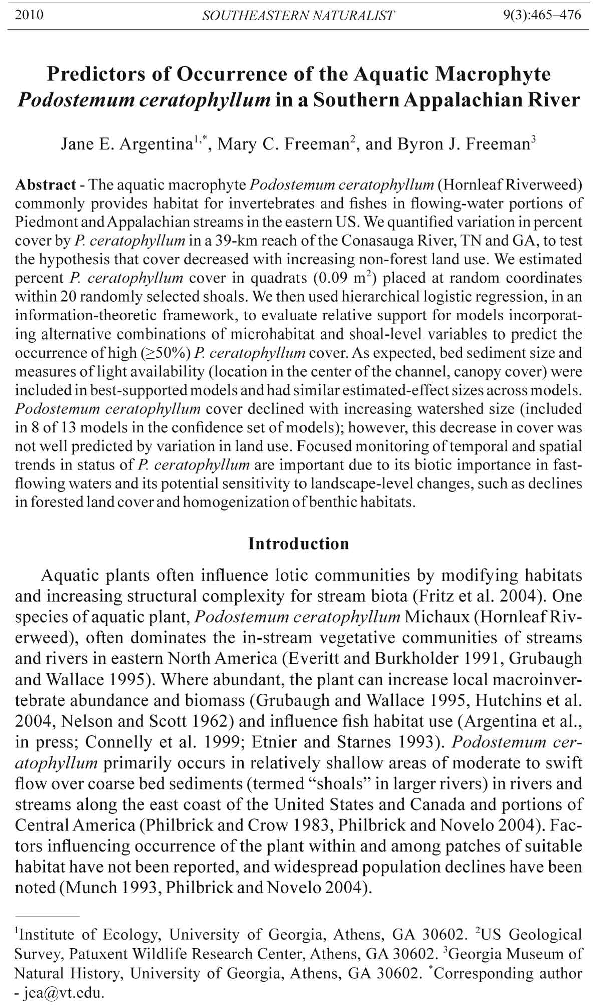
We mapped 131 shoals in the 38.8-km study reach of the Conasauga River
(Fig. 1). Total shoal habitat in that stretch of the river was 13.6 km out of the
total 38.8 km, or 33% of the study reach. The 20 shoals randomly selected
Figure 1. Location of the Conasauga River, TN and GA (inset), and mapped and
surveyed shoals within the study reach.
470 Southeastern Naturalist Vol. 9, No. 3
for sampling encompassed 1.5 km and 11% of all available shoal habitat. The
shoals were steeper and longer upstream (Argentina et al. 2010) and became
less steep and shorter downstream. Average sediment size was 560–690 mm
in the upstream-most portion of the reach and decreased to 14–44 mm in the
downstream half of the reach. On average, shoals were separated upstream
and downstream by 375 m from other shoals, and the distance between shoals
increased downstream. Land use in the basin shifts from primarily forest in the
headwaters, to increasing agricultural use in the middle of the reach and urban
influence in the downstream sections. Estimated percent total forest cover in
the basin decreases from about 99% to 68% from the upstream to downstream
boundaries of the study reach. This pattern corresponds to an increase from
0.6% to 6% in developed land cover (including low- and high-density developed),
and from 0.04% to 21.9% in agricultural land covers (grassland, pasture,
and row crop), from upstream to downstream (Argentina et al. 2010).
Longitudinal trends in P. ceratophyllum occurrence
Percent P. ceratophyllum cover (quantified as the percent of squares
within the sampling frame occupied) averaged from less than 1% to 55%
across the 20 randomly selected shoals (Fig. 2), with an average cover of
17%. At most sampled shoals, P. ceratophyllum biomass and surface area appeared
sparse, even when measured cover (i.e., number of squares occupied)
was high. Ash-free biomass (ln-transformed) measured at 3 shoals increased
with increasing cover of P. ceratophyllum (P <0.05), although the relation
was not strongly linear (r2 = 0.35; Fig. 3).
Hierarchical modeling to relate physical variables to the probability of
≥50% P. ceratophyllum cover resulted in nine models in the confidence set
Figure 2. Number of sampling quadrats with greater than 50% coverage out of 50
samples at each of the 20 shoals. Shoals are plotted (not to scale) from upstream to
downstream and labeled as distance from the mouth.
2010 J.E. Argentina, M.C. Freeman, and B.J. Freeman 471
of models (i.e., with model weights within 1/8th of the top model; Table 2). The
two observation-point variables, bed sediment size and location within the
channel (within 25% of the edge or in the middle 50%), were present in all models
in the confidence set, indicating microhabitat characteristics were direct
drivers of P. ceratophyllum cover. Each of the shoal-specific variables was present
in at least one of the models in the confidence set. The best-supported model
contained location within the channel, median sediment size, percent canopy
cover, and drainage area. The next best-supported model was 58% as likely to
be the best model and included location within the channel, median sediment
size, and percent canopy cover as in the top model, but instead of drainage area
it included percent row-crop land-cover in the watershed (Table 2). All the
other models within the confidence set were less than 50% as likely as the bestsupported
model to be the best model among those evaluated.
Model parameter estimates were strongly consistent among models for
the two observation-points variables (location within the channel and sediment
size), relatively consistent for effects of canopy cover and drainage
area, and variable for effects of slope and the two land-cover variables.
Overall, the strongest drivers of high P. ceratophyllum cover in our data
set were location in the center 50% of the channel, sediment size, drainage
area, and canopy cover. Across all models, P. ceratophyllum was 2.9 to 3.0
times more likely to have high cover in the center half of the channel rather
than near the edges (Table 3; odds ratios were estimated as e(parameter estimate)
[Agresti 2002], and range from 2.9 to 3.0 for the variable location in channel).
Also across all models, high P. ceratophyllum cover was about 3% more
likely with each 10-mm increase in sediment size (Table 3; odds ratios were
estimated as e(parameter estimate, 1 mm increase )(10), and ranged from 1.028 to 1.029).
Figure 3. Podostemum ceratophyllum biomass (ash-free dry mass, ln (g) AFDM) collected
from sampling quadrats plotted in relation to number (0 to 16) of quadrat units
occupied. A simple linear regression fit is imposed on the data, as ln mass = -2.3699
+ 0.2021(units occupied); r2 = 0.35.
472 Southeastern Naturalist Vol. 9, No. 3
The probability of high P. ceratophyllum cover decreased by an estimated
2 to 3% with each 1% increase in average site canopy cover (Table 3, odds
ratios ranged from 0.97 to 0.98). The probability of high P. ceratophyllum
cover also decreased about 3% for every 10-km2 increase in drainage area
(Table 3; odds ratios were estimated as e(parameter estimate, 1 km increase )(10), and ranged
from 0.96 to 0.97). Effects of the remaining variables on P. ceratophyllum
cover were imprecisely estimated (shown by large standard errors on parameter
estimates) and inconsistent among the models that included these
variables (Table 3). The second-most strongly supported model included
an estimated decline of 31% (odds ratio = 0.69) in the occurrence of high
P. ceratophyllum cover with each 1% increase in row-crop land use, but 95%
confidence intervals for the estimated effect of row-crop land use include 0
(no effect).
Discussion
Podostemum ceratophyllum generally occurs in high-velocity, wide,
shallow shoal habitat, typically characterized by coarse bed sediments
and relatively steep stream slope (Hutchens et al. 2004, Nelson and Scott
1962). Our models indicate local features (sediment size, location in the
channel) are better predictors of occurrence of P. ceratophyllum than shoal
slope or watershed land use. From our predictive models, P. ceratophyllum
is more likely to occur in the center of the channel and in areas with larger
sediment sizes, indicating strong physical control on its presence. Because
P. ceratophyllum persists in shoals by attaching to rock substrates, bedrock
and coarse bed sediments that are only displaced by high velocities provide
better habitat than shifting sand and gravel.
The large effect of location in the channel on high P. ceratophyllum cover
in our models suggests light availability also strongly influenced P. ceratophyllum
growth. We also found a negative effect of canopy cover at a shoal
on occurrence of high P. ceratophyllum cover. Everitt and Burkholder (1991)
similarly found that riparian shading influenced macrophyte community composition
in a stream flowing over a granite outcrop in North Carolina, with
P. ceratophyllum dominating only in the more open sites. We also observed a
five-fold increase in base-flow turbidity coincident with the longitudinal decrease
in P. ceratophyllum cover (Argentina et al. 2010), and it is conceivable
that elevated water turbidity could also limit light for benthic macrophytes.
We did not include turbidity in our models because we did not expect, a priori,
that a single point-in-time turbidity measurement would be predictive of
P. ceratophyllum cover. Additionally, observations of abundant P. ceratophyllum
in other large Piedmont rivers, including the Etowah (Hagler 2006), Flint
(Marcinek 2003), and Middle Oconee (Grubaugh and Wallace 1995) rivers in
Georgia, where water turbidity commonly exceeds levels in the downstream
portion of the Conasauga study reach (about 12 NTUs) suggested that turbidity
was unlikely to limit the plant in the Conasauga.
What did cause downstream declines in P. ceratophyllum cover in the
Conasauga mainstem shoals? We found no strong support for an effect
2010 J.E. Argentina, M.C. Freeman, and B.J. Freeman 473
Table 2. Logistic regression models for predicting high (≥50%) P. ceratophyllum cover, for the 9 best-supported models. Models are listed in order of support, showing
number of model parameters (K), AIC values, AIC values relative to the best-supported model (Δ AIC), and confidence-set adjusted model AIC weights (wi).
Location Sediment Canopy Drainage Agriculture Row-crop
Model in channel size cover (%) Slope area in buffer (%) land use (%) K AIC Δ AIC W(i)
1 X X X X 6 625.3 0 0.292
2 X X X X 6 626.4 1.1 0.169
3 X X X 5 626.7 1.4 0.145
4 X X X 5 627.1 1.8 0.119
5 X X X X 6 628.4 3.1 0.062
6 X X X X 6 628.4 3.1 0.062
7 X X X X 6 628.6 3.3 0.056
8 X X X 5 628.9 3.6 0.048
9 X X X X 6 629.0 3.7 0.046
Table 3. Parameter estimates (and standard errors) for predictor variables included in logistic regression models for predicting high (≥50%) P. ceratophyllum
cover, for the 9 best-supported models. Models are listed in order of support as in Table 2. The random effect estimate is also shown for each model.
Variables included in model
Location in Canopy Agriculture Row-crop
Model channel Sediment size cover (%) Slope Drainage area in buffer (%) land use (%) Random effect
1 1.085 (0.230) 0.0028 (0.0004) -0.027 (0.014) -0.0033 (0.0016) 0.800 (0.437)
2 1.084 (0.231) 0.0028 (0.0004) -0.025 (0.0003) -0.376 (0.228) 0.949 (0.493)
3 1.073 (0.230) 0.0029 (0.0004) -0.0041 (0.0018) 1.034 (0.532)
4 1.072 (0.230) 0.0029 (0.0004) -0.034 (0.016) 1.087 (0.561)
5 1.077 (0.230) 0.0028 (0.0004) 0.165 (0.318) -0.0035 (0.0021) 1.041 (0.532)
6 1.079 (0.231) 0.0028 (0.0004) -0.028 (0.017) 0.248 (0.296) 1.070 (0.545)
7 1.074 (0.230) 0.0029 (0.0004) -0.0035 (0.0041) 0.087 (0.531) 1.051 (0.548)
8 1.075 (0.231) 0.0028 (0.0004) 0.483 (0.290) 1.293 (0.631)
9 1.067 (0.230) 0.0028 (0.0004) -0.0041 (0.0018) -0.0044 (0.012) 1.032 (0.526)
474 Southeastern Naturalist Vol. 9, No. 3
of agricultural land use on occurrence of high P. ceratophyllum cover, as
we hypothesized, after accounting for effects of local factors. In the bestsupported
model with row-crop agriculture (model 2), the model coefficient
is negative, indicating the possibility of a negative effect of buffer loss and
agriculture in the buffer, but this is not consistent with model 7, and both
have large confidence intervals around these estimates. Agricultural land
cover in the riparian buffer upstream from each shoal showed a negative
effect on the occurrence of high P. ceratophyllum cover in only one model
in the confidence set, again with wide confidence intervals around this estimate.
Thus, these data did not show clear, direct effects of replacing forest
with agriculture on P. ceratophyllum. We also did not expect a natural decline
in P. ceratophyllum with increase in drainage area over the size range
of the Conasauga drainage (i.e., 200–800 km2), again because we know the
plant occurs abundantly in shoal habitats in other, larger Piedmont rivers
with higher drainage areas (e.g., >2000 km2, Flint River; >400 to1500 km2,
Etowah River; 1000 km2, Middle Oconee River).
We suspect that other, unmeasured changes associated with the downstream
decline of forested land cover are imposing stress on river biota in the
lower portion of the study reach. Increased baseflow turbidity along the mainstem
of the Conasauga River could be correlated with other changes in water
quality, as well as increased sedimentation (Walters et al. 2003). Stormflow
transport of sediment and contaminant loading from agricultural lands and
local urbanization may also increase in the lower portion of the study reach.
For example, we have observed dense benthic algal growths that covered
extensive areas of the channel, including patches of P. ceratophyllum, during
recent droughts in lower portions of the study reach (B.J. Freeman, unpubl.
data), possibly reflecting nutrient loading. Additionally, shoals are less numerous
and farther apart in the lower Conasauga, which could limit recolonization
following disturbance. Local population stability of P. ceratophyllum may
depend on clonal growth, as seed production is low compared to other plants
within Podostemaceae (mean of 12 per seed capsule, with only 39 capsules per
plant) and dispersal ability is unknown but assumed to be low (Philbrick and
Novelo 1997). Therefore, P. ceratophyllum may be slow to recover following
disturbances such as sediment scour or pulses of herbicides, especially if
plants have to recolonize habitat across long distances.
Focused monitoring efforts could help resolve trends in P. ceratophyllum
status and the relative influence of changing water quality, sedimentation,
or channel adjustments on P. ceratophyllum persistence. We have assessed
P. ceratophyllum by quantifying cover, which is relatively easily measured
and can provide a useful measure of macrophyte dominance (Everitt and
Burkholder 1991). We have also observed, however, that cover may not be
strongly correlated with plant biomass, and biomass might provide a better
measure of P. ceratophyllum contribution to benthic habitat for other biota.
We measured a wide range of plant biomass at varying levels of cover. Scour
and grazing (e.g., by birds, turtles, Castor canadensis Kuhl (Beaver); Parker
et al. 2007) can shorten P. ceratophyllum stems, reducing biomass but leaving
stems and root structure in place that may subsequently regrow. Adding
2010 J.E. Argentina, M.C. Freeman, and B.J. Freeman 475
a measure of average stem length to assessments of percent cover could
provide an effective field measure of P. ceratophyllum status that is more
closely correlated with biomass, without requiring the additional resources
needed to collect and process plant samples.
Understanding factors driving P. ceratophyllum is of interest particularly
because of the plant’s importance as habitat for macroinvertebrates (Grubaugh
and Wallace 1995, Hutchens et al. 2004, Nelson and Scott 1962) and fishes
(Argentina et al. 2010). Podostemum ceratophyllum is perhaps the most common
macrophyte in fast-flowing waters of Piedmont and Appalachian streams
(Mulholland and Lenat 1992, Wallace et al. 1992). Declining occurrence of the
plant may signal changes in occurrences and productivity of other stream biota.
Our research in the Conasauga River has illustrated that local bed sediment
size and average shoal canopy cover are important predictors of P. ceratophyllum
cover, and that influences of other factors can be evaluated effectively in
models that include local along with larger-scale factors.
Acknowledgments
We would like to thank members of the Freeman lab, especially Judith Barkstedt,
Paula Marcinek, James Norman, and Rebecca Bourquin, for help in the field and in
the lab. Comments by Jim Peterson, Tom Kwak, Stuart Welsh, and two anonymous
reviewers greatly improved this manuscript. Funding was provided by grants to B.J.
Freeman from the Georgia Department of Natural Resources and the Tennessee Wildlife
Resources Agency.
Literature Cited
Agresti, A. 2002. Categorical Data Analysis, Second Edition. John Wiley and Sons,
Inc., Hoboken, NJ. 710 pp.
Argentina, J.E., M.C. Freeman, and B.J. Freeman. 2010. Stream fish response to
local- and reach-scale variation in occurrence of a benthic aquatic macrophyte.
Freshwater Biology 55(3):643–653.
Burnham, K.P., and D.R. Anderson. 2002. Model Selection and Multimodel Inference:
A Practical Information-Theoretic Approach, Second Edition. Springer-
Verlag, New York, NY. 353 pp.
Connelly, W.J., D.J. Orth, and R.K. Smith. 1999. Habitat of the Riverweed Darter,
Etheostoma podostemone Jordan, and the decline of Riverweed, Podostemum
ceratophyllum, in the tributaries of the Roanoke River, Virginia. Journal of Freshwater
Ecology 14(1):93–102.
Etnier, D.A., and W.C. Starnes. 1993. The Fishes of Tennessee. The University of
Tennessee Press, Knoxville, TN. 689 pp.
Everitt, D.T., and J.M. Burkholder. 1991. Seasonal dynamics of macrophyte communities
from a stream flowing over granite flatrock in North Carolina, USA.
Hydrobiologia 222:159–172.
Fritz, K.M., M.M. Gangloff, and J.W. Feminella. 2004. Habitat modification by
the stream macrophyte Justicia americana and its effects on biota. Oecologia
140:388–397.
Grubaugh, J.W., and J.B. Wallace. 1995. Functional structure and production of the
benthic community in a Piedmont river: 1956–1957 and 1991–1992. Limnology
and Oceanography 40(3):490–501.
476 Southeastern Naturalist Vol. 9, No. 3
Hagler, M.M. 2006. Effects of natural flow variability over seven years on the occurrence
of shoal-dependent fishes in the Etowah River. M.Sc. Thesis. University of
Georgia, Athens, GA.
Hutchens, J.J., J.B. Wallace, and E.C. Romaniszyn. 2004. Role of Podostemum
ceratophyllum Michx. in structuring benthic macroinvertebrate assemblages in
a southern Appalachian river. Journal of North American Benthological Society
23(4):713–727.
Madsen, J.D., P.A. Chambers, W.F. James, E.W. Koch, and D.F. Westlake. 2001.
The interaction between water movement, sediment dynamics, and submersed
macrophytes. Hydrobiologia 444:71–84.
Marcinek, P.A. 2003. Variation of fish assemblages and species abundances in the upper
Flint River shoals, Georgia. M.Sc. Thesis. University of Georgia, Athens, GA.
Mulholland, P.J., and D.R. Lenat. 1992. Streams of the southeastern Piedmont, Atlantic
Drainage. Pp. 193–231, In C.T. Hackney, S.M. Adams, and W.H. Martin
(Eds.). Biodiversity of the Southeastern United States: Aquatic Communities.
John Wiley and Sons Inc., New York, NY.
Munch, S. 1993. Distribution and condition of populations of Podostemum ceratophyllum
(Riverweed) in Pennsylvania. Journal of the Pennsylvania Academy of
Science 67(2):5–72.
Nelson, D.J., and D.C. Scott. 1962. Role of detritus in the productivity of a rockoutcrop
community in a Piedmont stream. Limnology and Oceanography
7:396–413.
Parker, J.D., D.E. Burkepile, D.O. Collins, J. Kubanek, and M.E. Hay. 2007. Stream
mosses as chemically-defended refugia for freshwater macroinvertebrates. Oikos
116:302–312.
Philbrick, C.T., and G.E. Crow. 1983. Distribution of Podostemum ceratophyllum
Michx. (Podostemacae). Rhodora 85:325–341.
Philbrick, C.T., and R.A. Novelo. 1997. Ovule number, seed number, and seed size
in Mexican and North American species of Podostemaceae. Aquatic Botany
57:183–200.
Philbrick, C.T., and R.A. Novelo. 2004. Monograph of Podostemum (Podostemaceae).
Systematic Botany Monographs 70:1–106.
Royall, R.M. 1997. Statistical Evidence: A Likelihood Paradigm. Chapman and Hall,
New York, NY. 191 pp.
Sand-Jensen, K. 1998. Influence of submerged macrophytes on sediment composition
and near-bed flow in lowland streams. Freshwater Biology 39:663–679.
Singer, J.D. 1998. Using SAS PROC MIXED to fit multilevel models, hierarchical
models, and individual growth models. Journal of Educational and Behavioral
Statistics 24:323–355.
Wallace, J.B., J.R. Webster, and R.L. Lowe. 1992. High-gradient streams of the Appalachians.
Pp. 133–191, In C.T. Hackney, S.M. Adams, and W.H. Martin (Eds.).
Biodiversity of the Southeastern United States: Aquatic Communities. John Wiley
and Sons Inc., New York, NY. 779 pp.
Walters, D.M. 1997. The distribution, status, and ecology of the fishes of the Conasauga
River system. M.Sc. Thesis. University of Georgia, Athens, GA.
Walters, D.M., D.S. Leigh, and A.B. Bearden. 2003. Urbanization, sedimentation,
and the homogenization of fish assemblages in the Etowah River Basin, USA.
Hydrobiologia 494:5–10.


 The Southeastern Naturalist is a peer-reviewed journal that covers all aspects of natural history within the southeastern United States. We welcome research articles, summary review papers, and observational notes.