2015 Southeastern Naturalist Notes Vol. 14, No. 4
N50
D.C. Bragg
Clarifying Details on a 1930s-era Pine–Hardwood Stand in
Arkansas
Don C. Bragg*
Abstract - Data from recently discovered daily-work logs of US Forest Service (USFS) researcher
Russell R. Reynolds enabled me to clarify a study I published a decade ago on a 1930s-vintage unmanaged,
second-growth Pinus (pine)–hardwood stand in southeastern Arkansas. Though still too
vague to reveal every detail, Reynolds’ work logs confirmed a number of assumptions in the original
paper and provided me with the background information to herein describe a more precise sampling
framework for this 1930s-era study plot.
It is challenging to reconstruct historical forest conditions. Although a number of approaches
for such work have been described (e.g., Egan and Howell 2001), rarely do these
methods produce the desired detail regarding stand composition and structure. Quantitative
descriptions of forests across much of the southeastern US prior to the mid-20th century are
particularly uncommon and prove invaluable, when available. Approximately 10 y ago,
I discovered records of a 100% inventory of a mature, second-growth unmanaged Pinus
(pine)–hardwood “sample plot” in one of the earliest study files of Russell R. Reynolds (the
original researcher and project leader of the USFS’s Crossett Experimental Forest, Crossett,
AR). The data consisted of tree species, status (live or dead), diameter at breast height,
pine-growth rate, and bark thickness, as well as a brief description of the dimensions of the
plot (Bragg 2004).
Assumptions. While the stand structure and composition from these data provided a
good description of the sample plot, there was little information about who, when, why, and
where this sample plot was established. To address these shortcomings, I used information
in Reynolds’ original study files to approximate when and where this plot was established,
and by whom. The files did not state who had sampled the plot, but the handwriting was
consistent with that of Reynolds and, given that he was the only US Forest Service (USFS)
employee in the Crossett area at that time, it seemed highly likely that he had collected
this data. It was more difficult to establish when Reynolds had conducted the sampling.
Reynolds assisted the Crossett Lumber Company (now part of Georgia–Pacific, Crossett,
AR) in the spring of 1933, a relationship that quickly developed and, in December 1933,
the Crossett Experimental Forest was established on lands leased from the Crossett Lumber
Company. After the formal opening of the Crossett Experimental Forest on 1 January 1934,
Reynolds was fully occupied with its operation and had little time for fieldwork elsewhere.
Hence, I assumed Reynolds likely installed and measured the sample plot between 1933 and
1935 (Bragg 2004:328).
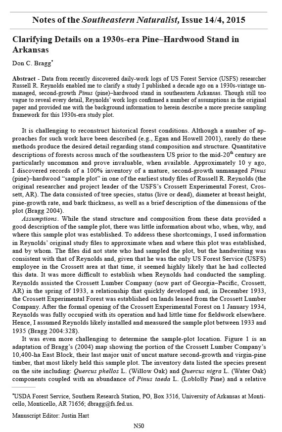
It was even more challenging to determine the sample-plot location. Figure 1 is an
adaptation of Bragg’s (2004) map showing the portion of the Crossett Lumber Company’s
10,400-ha East Block, their last major unit of uncut mature second-growth and virgin-pine
timber, that most likely held this sample plot. The inventory data listed the species present
on the site including: Quercus phellos L. (Willow Oak) and Quercus nigra L. (Water Oak)
components coupled with an abundance of Pinus taeda L. (Loblolly Pine) and a relative
*USDA Forest Service, Southern Research Station, PO, Box 3516, University of Arkansas at Monticello,
Monticello, AR 71656; dbragg@fs.fed.us.
Manuscript Editor: Justin Hart
Notes of the Southeastern Naturalist, Issue 14/4, 2015
N51
2015 Southeastern Naturalist Notes Vol. 14, No. 4
D.C. Bragg
rarity of Pinus echinata Mill. (Shortleaf Pine). Based on the species composition, Reynolds
likely placed the plot on a minor stream terrace—a common, but narrow habitat across
southern Arkansas. The terrace would have to have measured 220 m x 146 m, or 3.2 ha, to
be large enough to contain this sample plot, suggesting that it had been established along
one of the larger streams, the most likely candidate Chemin-A-Haut Creek (Fig. 1). My
identification of Chemin-A-Haut Creek as the most-probable plot location did not narrow
down the likely study area much because the terraces associated with that creek cover many
hundreds of hectares.
Findings. A fortuitous discovery in the archives of the Crossett Experimental Forest
helped me to clarify some of this uncertainty. Reynolds had kept a daily log of his
work-related activities from when he started in July 1931 with the USFS’s Southern Forest
Experiment Station until he retired in 1969, which included his work location and the
primary task(s) (Fig. 2). A copy of this record was kept at the Crossett Experimental Forest
from its formal opening on 1 January 1934, into the 1950s. Recently, I discovered Reynolds’
daily logs from 1931 to 1934 in some of his correspondence. According to his notes,
on 13 August 1933, Reynolds drove to Crossett from his New Orleans duty station to begin
his first major project in the area—marking the East Block for uneven-aged management
(Reynolds 1980). Reynolds worked most of the rest of the months of August, September,
Figure 1. An adaptation
of Figure 2
from Bragg (2004)
showing the thenestimated
location
of the study plot
(circled area).
2015 Southeastern Naturalist Notes Vol. 14, No. 4
N52
D.C. Bragg
October, and November in the East Block. His entry for Sunday, 17 September 1933, reads
as follows: “Spent part of day (4 hours) laying out a sample plot of 8 acres [3.2 ha] upon
which to collect growth and stand data.” This is exactly the size of the plot found in the
files, given in Bragg (2004), and that I was seeking to locate. There are no further entries
related to this plot until 20 November, when Reynolds “[b]egan taking tree measurements
and increment borings on a sample plot in the East Block”; he continued collecting data for
3 more days. It is now clear that Reynolds established the plot location in September 1933
and collected the data for this sample plot from 20 to 23 November 1933.
Why was this sample plot established? Given the location and some associated
correspondence found in the USFS study files, Bragg (2004:329–330) assumed that information
from the site was supposed to support the inventory work Reynolds was doing
for the Crossett Lumber Company. These data may have contributed to regional timber
assessments Reynolds worked on during this period. However, given when this plot was
Figure 2. Coversheet
of the daily-work
logs kept by Russell
R. Reynolds (pictured
in inset) during the
period of the establishment
and measurement
of this study
plot. Inset picture
from USFS archives,
circa 1930s.
N53
2015 Southeastern Naturalist Notes Vol. 14, No. 4
D.C. Bragg
established, the data were not part of the information Reynolds and fellow USFS forester
A.E. Wackerman gathered for the Copeland Report (USFS 1933). Reynolds and Wackerman
were uncredited contributors to the section of the Copeland Report that reviewed the
state of private forestry in the early 1930s (Kirkland 1933). They provided brief size-class
descriptions of what constituted average and well-stocked Shortleaf Pine–Loblolly Pine
stands in northern Louisiana and southern Arkansas. Reynolds’ work logs in late 1932 and
early 1933 showed that he spent a considerable amount of time preparing materials for this
report. The Copeland Report was submitted to Congress in March of 1933, months before
the East Block sample plot was laid out and measured. I found clarifying information in
Reynolds’ work log. According to his 20 November 1933 entry, Reynolds specifically stated
that this sample plot helped to determine pine growth for a selective logging study on the
East Block for the Crossett Lumber Company.
Unfortunately, the entries related to this sample plot do not give its exact location; there
appears to be no surviving study plan, if one ever existed. However, in the days immediately
prior to and after this plot was laid out (mid-September 1933), Reynolds had been
selectively marking timber for the Crossett Lumber Company in Sections 1 and 2 of Township
19 South Range 7 West (T19S R7W). Early on 20 November 1933, when Reynolds
first collected data on this sample plot, he had worked a 10% cruise of the northern portion
of Section 3 in T19S R7W. Sections 1, 2, and 3 of T19S R7W are located just west of the
small community of Berlin, and they encompass some of the terraces along Chemin-A-Haut
Creek and its tributaries (Fig. 3) ~18 km ESE of the city of Crossett, AR. In sections 1 and 2,
the Chemin-A-Haut bottoms are over 1.5 km wide, and could easily contain the study plot.
Hanks Creek, a major tributary of Chemin-A-Haut, has an ~ 1/3–1/2-km-wide bottomland
Figure 3. Ashley County highway map (from 1936) showing the most probable location of the study
plot (Sections 1, 2, or 3 in T19S R7W; shaded area near the community of Berlin) as interpreted from
daily-work logs of Reynolds.
2015 Southeastern Naturalist Notes Vol. 14, No. 4
N54
D.C. Bragg
in Section 3, and thus also could have held this plot. Therefore, it is highly probable that
Reynolds established this sample plot somewhere in immediate proximity to Berlin, considerably
narrowing the possible location area suggested by Bragg (2004).
In summary, I confirmed that the previously described 1930s-era sample plot was established
and measured by Russell R. Reynolds in late 1933 near Berlin, AR, probably in
the Chemin-A-Haut Creek bottomlands. Historical study records and investigator notes
are invaluable tools that can be used to improve the knowledge of past research and this
information should be archived so that it remains accessible well after the original study
has been closed.
Acknowledgments. First, I would like to recognize the foresight of Russ Reynolds to
record his activities many decades ago, which made this paper and the previous one possible.
I am also grateful to the following for their assistance on this effort: O.H. “Doogie”
Darling, Mike Shelton, Jim Guldin, and 2 anonymous reviewers. This work was supported
by the US Forest Service’s Southern Research Station.
Literature Cited
Bragg, D.C. 2004. Composition and structure of a 1930s-era pine–hardwood stand in Arkansas.
Southeastern Naturalist 3(2):327–344.
Egan, D., and E.A. Howell (Eds.). 2001. The Historical Ecology Handbook. Island Press, Washington,
DC. 457 pp.
Kirkland, B.P. 1933. Status and opportunities of private forestry. Pp. 891–984, In US Forest Service:
A National Plan for American Forestry, Volume I. Document 12, 73rd Congress, 1st Session. US
Government Printing Office, Washington, DC. 1677 pp.
Reynolds, R.R. 1980. The Crossett Story: The Beginning of Forestry in Southern Arkansas and Northern
Louisiana. USDA Forest Service General Technical Report SO-32. Southern Forest Experiment
Station, New Orleans, LA. 40 pp.
US Forest Service (USFS). 1933. A National Plan for American Forestry. Volume I. Document 12,
73rd Congress, 1st Session. Government Printing Office, Washington, DC. 1677 pp.


 The Southeastern Naturalist is a peer-reviewed journal that covers all aspects of natural history within the southeastern United States. We welcome research articles, summary review papers, and observational notes.