Southeastern Naturalist
E.R. Boitet and A.J. Mead
2014 Vol. 13, No. 1
176
2014 SOUTHEASTERN NATURALIST 13(1):176–190
Application of GIS to a Baseline Survey of Vertebrate
Roadkills in Baldwin County, Georgia
Evan R. Boitet1,2 and Alfred J. Mead1,*
Abstract - Physical attributes, traffic volume, and landscape patterns on a particular road
are expected to influence the frequency of vertebrate road fatalities. In this study, we surveyed
22.17 km of roadways in Baldwin County, GA, 171 times (3791.1 km total) for vertebrate
roadkills over a calendar year. We coded the survey route—consisting of portions
of US Highway 441, GA Highway 212, and Meriwether/Lowe Road—for differing habitat
types and obstacles along its length, and mapped the spatial data in ArcGIS. We recorded
178 vertebrate roadkills representing 19 species, primarily mammals, with Odocoileus virginianus
(White-tailed Deer; n = 46) and Didelphis virginiana (Virginia Opossum; n = 39)
most frequently observed. We calculated a roadkill rate of 8.03/km/yr. US 441, which has
the most lanes, highest traffic volume, and greatest verge width, had the highest roadkill rate
(10.95/km/yr) of the three sections. Seasonal differences in roadkill frequencies for the most
commonly observed species appear to be related to periods of ma ting or dispersal.
Introduction
The continuing growth and expansion of human populations exerts pressures
on wildlife due in part to habitat fragmentation (Watts et al. 2007). An impact of
particular concern is wildlife-vehicle collisions, which often result in increased
death rates for many wildlife species as well as possible injury and monetary loss
for drivers (Conover et al. 1995, Trombulak and Frissell 2000). In 1987, an estimated
1 million vertebrates were killed on roadways in the United States each day
(Lalo 1987), and this number has surely risen as human population densities and
the numbers of cars on roads have increased (Barthelmess and Brooks 2010). While
road mortality may not severely limit species with naturally high population numbers
and reproductive rates, populations of threatened or endangered species can be
severely impacted (Forman and Alexander 1998, Glista et al. 2008). Local populations
may be more sensitive to increased road mortality, especially when roadkill
rates exceed the rates of reproduction or immigration (Evink et al. 1996, Forman
1995, Forman and Alexander 1998, Forman et al. 1997). In addition to roadkills,
roads can fragment populations thereby reducing dispersal success and gene flow
(Conard and Gipson 2006, Maehr et al. 1991, Trombulak and Frissell 2000). Analysis
of roadkill rates at the local level provides a more accurate understanding of
the effects of human expansion in particular regions and illuminates many factors
associated with vertebrate road mortality.
1Department of Biological and Environmental Sciences, CBX 081, Georgia College and
State University, Milledgeville, GA 31061. 2Current address - Department of Genetics,
Box 2182, University of Alabama at Birmingham, Birmingham, AL 35294. *Corresponding
author - al.mead@gcsu.edu.
Manuscript Editor: Scott Markwith
Southeastern Naturalist
177
E.R. Boitet and A.J. Mead
2014 Vol. 13, No. 1
The frequency of wildlife-vehicle collisions is influenced by species-specific
and species-general factors (Coffin 2007, Collins and Kays 2011, Glista et al. 2008)
as well as road characteristics such as width (number of lanes), speed limit, traffic
volume, verge width (shoulder or right-of-way), and physical barriers present along
the roadway (Forman and Alexander 1998, Inbar and Mayer 1999). Animals may be
attracted to the verge along roads due to an edge effect and food availability (Coffin
2007). Medium-sized mammals such as Didelphis virginiana (Virginia Opossum)
likely are attracted to roadways by the presence of carrion, and Sylvilagus floridanus
(Cottontail Rabbit) are attracted by green sprouts following mowing (Forman
and Alexander 1998). In addition, wider verge may provide more attractive grazing
areas for larger herbivores, such as Odocoileus virginianus (White-tailed Deer).
Recently, analyses of the factors influencing wildlife-vehicle collisions have focused
on species-specific road mortality by classifying spatial patterns adjacent to
roadways and utilizing a geographic information system (GIS) to interpret the data
(Clevenger et al. 2001, Slater 2002). GIS analyses have illustrated the relationships
of land cover and roadside obstacles (fences, guardrails, water, etc.) with areas of
high vertebrate road mortality (Forman and Alexander 1998, Glista et al. 2008),
indicating that obstacles along the verge of roadways may funnel species around
obstructions and create roadkill hotspots (Ramp et al. 2005). Further identification
of spatial patterns that influence wildlife-vehicle collisions will increase our understanding
of where these hotspots may occur.
Roadkill studies conducted throughout Canada and the US have focused mainly
on mammalian roadkills (Alexander et al. 2005, Barthelmess and Brooks 2010,
Caro et al. 2000, Clevenger et al. 2003, Conard and Gipson 2006, Forman and Alexander
1998, Gehrt 2002, Kanda et al. 2006), although some studies addressing
amphibian roadkills have been published in recent years (Glista et al. 2008, Langen
et al. 2007). Within the southeastern US, most studies have documented roadkills
along roads in Florida (Cristoffer 1991, Inbar and Mayer 1999, Loughry and Mc-
Donough 1996, Main and Allen 2002, Smith and Dodd 2003). The only published
study of roadkills in Georgia is a state highway mortality report prepared by the
Georgia Game and Fish Division (Johnson 1986). The present study examined
vertebrate roadkills in Baldwin County, GA, by conducting surveys on three roads
of comparable length but differing road width, traffic volume, and verge width.
The research objectives were to (1) determine which species are most commonly
detected as roadkill, (2) investigate seasonal effects on the occurrence of the most
commonly detected roadkilled species, and (3) compare the distribution of detected
roadkills in relation to the number of lanes/traffic volume, land cover, and roadside
obstacles utilizing GIS.
Methods
Baldwin County encompasses 694.1 km2 in central Georgia and has approximately
44,500 residents, of which approximately 17,500 reside within Milledgeville
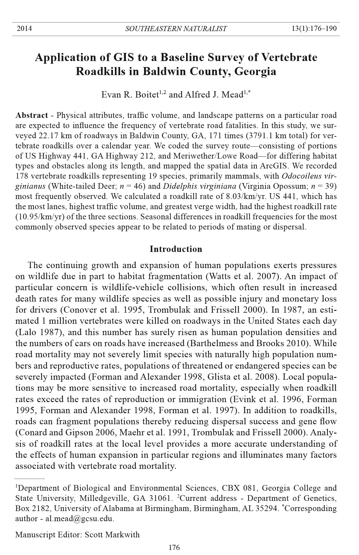
(2011 US Census). The roadkill survey route (Fig. 1) was driven by a single observSoutheastern
Naturalist
E.R. Boitet and A.J. Mead
2014 Vol. 13, No. 1
178
Figure 1. Location of roads travelled and distribution of the 178 roadkills (black squares)
recorded in the 2011 Baldwin County, GA, roadkill survey. A = US Highway 441, B = GA
Highway 212, C = Meriwether Road, D = Lowe Road, M = city of Milledgeville. Raster image
obtained from Georgia GIS Data Clearinghouse (US Department of Commerce 2005).
Data projected in ArcMAP to NAD 83 UTM Zone 17N.
Southeastern Naturalist
179
E.R. Boitet and A.J. Mead
2014 Vol. 13, No. 1
er at speeds less than, if possible, or equal to the posted speed limit (Table 1) during
daylight morning hours (prior to noon). We surveyed each section of the route
in succession three times per week (typically Monday, Wednesday, Friday) from 5
January 2011 to 5 January 2012. We traveled the route each day of one week four
times during the observation period (once each season) in order to determine the
length of time roadkilled specimens typically remained on the roadway. We drove
the 22.17-km survey route 171 times, and recorded all roadkilled mammals, birds,
and reptiles visible (on asphalt and in the verge) from the moving survey vehicle.
For each roadkilled specimen, we recorded the species, date, and UTM coordinate
using a Garmin Dakota 20 GPS. We counted all roadkills only once, even if they
remained on the roadway for the succeeding survey trip. For purposes of analysis,
we divided the observation period into winter (December–February), spring
(March–May), summer (June–August), and fall (September–November). We carried
out seasonal analyses for species that were recorded 10 or more times during
the year. We caculated roadkill rates (for all species and mammals only), expressed
as roadkills/km/yr (RKY), for each section of the survey route, each land-cover
class, and each obstacle class by dividing the number of detected roadkills in a section
or class for the year by the length of road in that section or class.
The selected survey route represented a mixture of road sizes and spatial conditions
(Fig. 1, Table 1). We chose cach of the three sections based on length (e.g.,
all roads were within ± 0.97 km in length) and connectivity. One section combined
two intersecting, similarly classified roads (Meriwether/Lowe Road). We obtained
the most recent annual average daily traffic (AADT) data for each section
from the Georgia Department of Transportation (Table 1; STARS 2010). We determined
the average verge width for each section using a metric tape. The survey route
consisted of portions of US Highway 441, GA Highway 212, and Meriwether/Lowe
Road (Fig. 1). The US 441 section (Fig. 1: label A) is a major 5-lane highway mostly
within the Milledgeville city limits and traverses a variety of land-cover types and
roadside obstacles. US 441 crosses Tobler Creek, Nancy Branch Creek, and one
seasonal stream, and at one point borders a small, 1–2-acre wetland. The GA 212
segment (Fig. 1: label B) is a two-lane highway in a more rural part of the county. Forests
dominate the landscape around this route section, but there are a few residential
Table 1. Characteristics of roads surveyed in the three sections of the 22.17-km roadkill survey route
in Baldwin County, GA. Meriwether (4.92 km) and Lowe (1.91 km) roads were combined (Me-
Lo Rd.) to make a 6.83-km section with a combined roadkill rate. The average annual daily traffic
(AADT) was obtained from the Georgia Department of Transportation (STARS 2010). Roadkill rates
were determined for all species and mammals only.
# traffic Speed limit AADT Verge Roadkills (/km/yr)
Road name Length (km) lanes (km/hr) (vehicles/yr) width (m) Total Mammals
US Hwy 441 7.58 5 72.4–88.5 16,900 8.68 10.95A 10.42
GA Hwy 212 7.76 2 88.5 4040 6.39 6.19 5.67
Me-Lo Rd. 6.83 2 72.4 1820 3.26 6.89 6.30
ASignificant difference (α = 0.05) between US 441 and GA 212 and Me-Lo Rd.
Southeastern Naturalist
E.R. Boitet and A.J. Mead
2014 Vol. 13, No. 1
180
areas. This portion of GA 212 mostly follows a dry ridge, yet crosses three seasonal
streams, and parallels a spur of the Southern Railway along the middle one-third
of the route. The combined Meriwether/Lowe Road section consists of two lanes
running east–west between US 441 and GA 212. Meriwether Road (Fig. 1: label C)
crosses one seasonal creek and private residences line most of its length. Lowe Road
(Fig. 1: label D) is bordered by forests as well as private residences, crosses a small
beaver pond on Buck Creek, and crosses one seasonal stream.
We compiled a geodatabase of the survey route in ArcGIS 10 (ESRI). We coded
the sampled roads for spatial analysis using collected GPS data as well as Baldwin
County road shapefiles obtained from the Georgia GIS Data Clearinghouse (US
Department of Commerce 2005). We divided the survey route into 173 segments
of ≥30 m determined by the spatial pattern along the roadway. Attributes were assigned
to each segment according to the land cover and obstacles along the verge.
Land-cover classes included field, forest, residential, and mixed (differing habitats
on either side of the road). Obstacle classes included absent, fence, and mixed. We
projected the GPS location for each roadkill in ArcMap allowing for the correlation
of the roadkill locations with the spatial surroundings. All GPS coordinates were
projected in ArcMAP to NAD 83 UTM Zone 17N. We determined significant differences
between the roadkill rates (overall and individually for the 5 most commonly
observed species) for each road, season, land-cover type, and obstacle class using a
rate-difference analysis by calculating a 95% confidence interval for difference (Sahai
and Khurshid 1996). If the confidence interval for the difference included zero,
we concluded that the roadkill rates did not differ significantly at α = 0.05.
We consider the roadkill totals for the survey route to be conservative based on a
number of factors. First, visibility during sampling was limited on some days due to
rain, sun, fog, or high traffic volume. Second, travelling over hills and around curves
inhibited the single surveyor’s field of view. Third, animals may have been removed
from the road either by Georgia Department of Transportation workers, civilians
(especially pets in residential areas), or scavengers. Fourth, smaller vertebrates, if
not located on the asphalt, were difficult to detect from a moving survey vehicle.
Fifth, the verge-mowing regime changed the height of the roadside vegetation at different
times during the year, altering visibility. Sixth, since the route was surveyed
in the morning, nocturnal species (nighttime and early morning kills) were more
likely to be observed than diurnal species (daytime kills). Lastly, some fatal wildlife-
vehicle collisions do not result in an animal dead on the road; some animals may
not perish until they have fled the roadway and verge. On occasion, scavengers such
as Cathartes aura (Turkey Vulture), Coragyps atratus (Bechstein) (Black Vulture),
and Corvus brachyrhyncos (American Crow) would be on a carcass while the survey
route was driven, increasing the likelihood of detection, even when the roadkill
was displaced from the roadway.
Results
From 5 January 2011 to 5 January 2012, we conducted 171 surveys for a total
of 3791.1 km traveled, and recorded 178 roadkills representing 19 species for an
Southeastern Naturalist
181
E.R. Boitet and A.J. Mead
2014 Vol. 13, No. 1
average of 8.03 RKY (Table 2). Mammals accounted for 95% of all detected roadkills
(167/178), and the five most commonly encountered species, White-tail Deer
(n = 46), Virginia Opossum (n = 39), Sciurus carolinensis (Eastern Gray Squirrel;
n = 28), Dasypus novemcinctus (Nine-banned Armadillo; n = 22), and Procyon
lotor (Northern Raccoon; n = 11), accounted for 87% of the roadkilled mammals
(146/167). Turkey Vultures (n = 4) were the most commonly recorded bird. No
reptilian species was recorded more than once.
Significantly more roadkill (α = 0.05) were detected on US 441 compared to GA
212 and Meriwether/Lowe Road (Table 1). On US 441, 79 mammals, 2 birds, and
2 reptiles were recorded (n = 83, 10.95 RKY). US 441 has the most lanes, highest
average annual daily traffic estimate, and greatest verge width. Additional significant
differences (α = 0.05) among road transects included more Opossums detected
on US 441 compared to Meriwether/Lowe Road, more Armadillos found on US 441
compared to GA 212 and Meriwether/Lowe Road, and more Raccoons recorded on
US 441 compared to GA 212 (Table 2). For GA 212, we found 44 mammals and 4
birds, but no reptiles, dead (n = 48, 6.19 RKY). Observations on Meriwether/Lowe
Road recorded 43 mammals, 3 birds, and 1 reptile dead (n = 47, 6.89 RKY). This
section has the narrowest verge width and the lowest posted speed limit (72.4 km/
hr [45 mph]) along its entire length.
Table 2. Vertebrate taxa recorded along the roadkill survey route in Baldwin County, GA. The Meriwether/
Lowe Road section is abbreviated Me-Lo Rd.
US Hwy GA Hwy Me-Lo
Species Common name 441 212 Rd. Total
Odocoileus virginianus (Zimmermann) White-tailed Deer 18 14 14 46
Didelphis virginiana Kerr Virginia Opossum 20A 13 6 39
Sciurus carolinensis Gmelin Eastern Gray Squirrel 7 7 14 28
Dasypus novemcinctus L. Nine-banded Armadillo 16B 6 0 22
Procyon lotor (L.) Northern Raccoon 7C 1 3 11
Felis catus L. Domestic Cat 4 0 1 5
Sylvilagus floridanus Allen Cottontail Rabbit 2 0 2 4
Canis lupus familiaris L. Domestic Dog 2 1 1 4
Urocyon cinereoargenteus (Schreber) Gray Fox 2 0 1 3
Sciurus niger L. Fox Squirrel 0 2 0 2
Mephitis mephitis (Schreber) Striped Skunk 1 0 1 2
Cheldyra serpentine (L.) Common Snapping Turtle 1 0 0 1
Elaphe obsoleta (Say in James) Rat Snake 1 0 0 1
Crotalus horridus L. Timber Rattlesnake 0 0 1 1
Cathartes aura (L.) Turkey Vulture 1 2 1 4
Cardinalis cardinalis (L.) Northern Cardinal 0 0 2 2
Corvus brachyrhyncos Brehm American Crow 0 1 0 1
Zenaida macroura (L.) Mourning Dove 1 0 0 1
Strix varia Barton Barred Owl 0 1 0 1
Total 83 48 47 178
ASignificant difference (α = 0.05) between US 441 compared to Me-Lo Rd.
BSignificant difference (α = 0.05) between US 441 compared to GA 212 and Me-Lo Rd.
CSignificant difference (α = 0.05) between US 441 compared to GA 212.
Southeastern Naturalist
E.R. Boitet and A.J. Mead
2014 Vol. 13, No. 1
182
During each season, an observer drove the survey route each day of one week.
During these 28 days of sampling, 27 roadkills were recorded. The length of time
roadkills remained on the roadway varied. Most roadkills initially on the asphalt
were no longer present within 24 hours (59.3%). Some specimens remained on
the roadway for 48 hours (22.2%), and some even ≥72 hours (18.5%). The bony
carapace of Armadillos tended to remain long after the flesh was removed. Large
roadkills, such as White-tailed Deer, if dead in the roadway and posing a driving
hazzard, were likely removed by state workers or civilians.
There was no significant difference in the total number of detected roadkills by
season (Table 3). The average number of roadkills recorded per month was 14.8,
with the highest occurrence in May (n = 21) and the lowest in November (n = 7).
Significant seasonal differences (α = 0.05) at the individual species level included
White-tailed Deer roadkills more common in winter compared to spring and summer,
Opossums found dead more frequently during spring compared to winter and
summer, Gray Squirrels found more often during spring compared to winter and fall,
and Armadillo roadkills more abundant during summer compared to winter, spring,
and fall (Table 3).
Roadkills were widely distributed among the various land-cover and obstacle
classes (Fig. 1; Tables 4, 5). Overall, the only statistical difference (α = 0.05) was
more roadkills in mixed versus forest cover types. Fields accounted for 2.4% of
the survey route and were associated with the highest roadkill rate (9.26 RKY).
White-tailed Deer roadkills were more commonly associated (α = 0.05) with fields.
Mixed land cover, 53% of the survey route, had a slightly lower roadkill rate (8.91
RKY) by comparison. Opossums were detected more frequently (α = 0.05) in
mixed versus residential areas. Roadkill rates in residential areas (12.8% of route)
were comparable (8.80 RKY) to those in the mixed land cover. Armadillo roadkills
were more abundant (α = 0.05) in residential areas compared to forest. Forested
areas accounted for the second largest land-cover class (31% of route), but had
only 42 observed roadkills and the lowest roadkill rate (6.02 RKY). Areas lacking
Table 3. Seasonal records for the five most commonly detected roadkilled species in the Baldwin
County, GA, roadkill survey. Each species was observed a minimum of 10 times during the one-year
observation period. These five species accounted for 148 of 178 observed roadkills. Winter = December–
February; spring = March–May; summer = June–August; fall = September–November.
Taxa Winter Spring Summer Fall
White-tailed Deer 22A 10 5 11
Virginia Opossum 7 17B 5 10
Eastern Gray Squirrel 4 14C 6 4
Nine-banded Armadillo 1 4 13D 4
Northern Raccoon 4 1 5 1
Total 38 46 34 30
ASignificant difference (α = 0.05) between winter compared to spring and summer.
BSignificant difference (α = 0.05) between spring compared to winter and summer.
CSignificant difference (α = 0.05) between spring compared to winter and fall.
DSignificant difference (α = 0.05) between summer compared to winter, spring, and fall.
Southeastern Naturalist
183
E.R. Boitet and A.J. Mead
2014 Vol. 13, No. 1
roadside obstacles accounted for 62.3% of the survey route and the majority (67%)
of the roadkills (8.62 RKY). Significantly (α = 0.05) more White-tailed Deer were
detected in areas lacking obstacles compared to the mixed class. Segments with
a mixed arrangement of obstacles showed the second highest roadkill rate (7.04
RKY). Fenced areas constituted only 1% of the route and, with only one Whitetailed
Deer detected, had the lowest frequency of roadkills (4. 55 RKY).
Discussion
Eighty-seven percent of the roadkilled mammals detected in this study belonged
to the five most frequently encountered species: White-tailed Deer, Virginia
Table 5. Five most commonly detected roadkill species in each land cover and obstacle class along the
roadkill survey route in Baldwin County, GA. See Table 5 for class information.
Class Deer Opossum Squirrel Armadillo Raccoon
Land cover
Field 4A 0 0 0 0
Mixed 28 26B 13 12 8
Residential 5 1 6 6C 1
Forest 9 12 9 4 2
Obstacles
Absent 35D 26 20 11 7
Mixed 9 13 8 11 4
Fence 1 0 0 0 0
Total 46 39 28 22 11
ASignificant difference (α = 0.05) between field compared to mixed, residential and forest cover types.
BSignificant difference (α = 0.05) between mixed compared to residential cover types.
CSignificant difference (α = 0.05) between residential compared to forest cover types.
DSignificant difference (α = 0.05) between areas lacking obstacles compared to mixed.
Table 4. Observed number of roadkills in each land-cover and obstacle class along the roadkill survey
route in Baldwin County, GA. Each class indicates the same spatial pattern present along both sides
of the roadway for a minimum of 30 m. Mixed represents conditions where the cover or obstacles
along one side of the roadway differs from the other side. Absent indicates no obstacles were present
on either side of the roadway.
Class Length (km) % total length # roadkills Roadkills/km/yr
Land cover
Field 0.54 2.4 5 9.26
Mixed 11.79 53.2 105 8.91A
Residential 2.84 12.8 25 8.80
Forest 6.98 31.5 42 6.02
Obstacles
Absent 13.80 62.2 119 8.62
Mixed 8.10 36.5 57 7.04
Fence 0.22 1.0 1 4.55
ASignificant difference (α = 0.05) between mixed compared to forest cover type.
Southeastern Naturalist
E.R. Boitet and A.J. Mead
2014 Vol. 13, No. 1
184
Opossum, Eastern Gray Squirrel, Nine-banded Armadillo, and Raccoon. Even
though Johnson (1986) questioned the accuracy of the data collected by GA Game
and Fish technicians, he found Virginia Opossums, Cottontail Rabbits, Eastern
Gray Squirrels, Raccoons, and White-tailed Deer as the most abundant roadkilled
mammals in Georgia during the late 1970s and early 1980s. After 30 years, besides
the Nine-banded Armadillo, which was not widely established in the state at the
time, the same species are generally still the most commonly detected roadkills
in the area. The three studies in Florida that recorded all roadkilled species found
similar dominant mammalian taxa (Cristoffer 1991, Main and Allen 2002, Smith
and Dodd 2003). This high frequency of medium-sized mammals is evident in roadkill
species lists from throughout North America (Barthelmess and Brooks 2010,
Caro et al. 2000, Conard and Gipson 2006, Glista and DeVault 2008, Seibert and
Conover 1991, Smith-Patten and Patten 2008), and is probably due to the greater
likelihood of this size carcass remaining on the road after death. Medium-sized
mammals are likely to be killed instantly by collisions, are too large to be easily
carried from the roadway by scavengers, and remain intact for identification (Main
and Allen 2002).
In central Georgia, collisions with White-tailed Deer are generally the most
dangerous and costly wildlife-vehicle collisions for drivers. White-tailed Deer
have variable reproductive seasons in the southern US; however, breeding generally
peaks in November (Miller et al. 2003). Nearly half of the recorded roadkilled
White-tailed Deer were found in December and January, during the latter half of
the breeding season, consistent with observations in other states (Allen and Mc-
Cullough 1976, Hubbard et al. 2000, Hussain et al. 2007, McShea et al. 2008).
Although it has been suggested that White-tailed Deer may change their behavior
in order to avoid habitats near roads because of elevated traffic noise (Forman and
Deblinger 2000), it is not evident in Baldwin County. An increase in roadkill frequency
during breeding season was evident for Nine-banded Armadillos as well.
Nine-banded Armadillos, which breed June through August in Georgia (Layne
2003), were most frequently observed in summer. However, a switch to more
nocturnal activity may have resulted in increased roadkill rates in summer months
(Inbar and Mayer 1999, Loughry and McDonough 1996) and the relative absence
of Nine-banded Armadillo roadkills during the fall and winter was likely associated
with their reduced activity during periods of colder weather in central Georgia.
For other medium-sized mammals in the US, the correlation of roadkills with
seasons appears to vary between regions (Conard and Gipson 2006, Caro et al.
2000, Smith-Patten and Patten 2008). In the Southeast, male Virginia Opossums are
more active during the winter, resulting in higher road fatalities during that time
of year (Ryser 1995). Patterson and Mead (2008) found a 4:1 male-to-female ratio
for roadkilled Virginia Opossums (n = 59) collected in Baldwin County during the
winter months of 2002 and 2004. The breeding season for Virginia Opossums in
Georgia occurs from late December to mid-January, and may begin again in late
summer (Gardner and Sunquist 2003). Virginia Opossums were recorded most
frequently in this study in the spring, which does not appear to correlate with the
Southeastern Naturalist
185
E.R. Boitet and A.J. Mead
2014 Vol. 13, No. 1
breeding season. However, young Virginia Opossums disperse approximately 120
days following birth (132 days after conception). If adults are breeding in December
and early January, then the increase in movement across roadways during April
and May could be related to dispersal. The observed increase in Eastern Gray Squirrel
roadkills does not appear to correlate with breeding season either. Eastern Gray
Squirrels in the Southeast have winter (January–February) and summer (May–July)
breeding seasons (Edwards et al. 2003); however, the only increase in Baldwin
County Eastern Gray Squirrel roadkills was during spring. This increase could be
attributed to the sexual maturation and dispersal of sub-adults prior to the summer
breeding season (Edwards et al. 2003).
Raccoons have two mating seasons: February–March and May–June (Gehrt
2003). However, the small number of Raccoon roadkills found in this survey did not
reveal seasonal correlations. Gehrt (2002) also did not find a correlation between
Raccoon roadkills and breeding season, but found that Raccoon road mortality increases
with increases in traffic volume to a point above which Raccoons modify
their behavior and avoid heavily traveled roads. This behavioral change results in
more roadkilled Raccoons found on lesser-traveled roads. However, in our Baldwin
County study, significantly more Raccoons were detected on US 441, the busiest
section of the survey route, compared to GA 212.
The significantly higher overall roadkill rate on US 441 suggests a link between
an increased occurrence of roadkills and the numbers of lanes and traffic volume.
Baker et al. (2004) found that more medium-sized mammals are killed on major
roads like US 441. However, the wider area of asphalt on US 441 and the greater
likelihood of noticing a roadkill on the pavement rather than off in the verge may
well increase the likelihood of detection there. Jaarsma et al. (2006) concluded that
wider roads are associated with higher traffic volume and higher vehicle speed, resulting
in increased collisions. Cristoffer (1991) found increased numbers of kills
with increased speed, and Alexander et al. (2005) found that road permeability with
regards to animal movement across the landscape declines with increased traffic
volume. In contrast to the Baldwin County numbers, Clevenger et al. (2003) found
lower roadkill rates for mammals on high-volume roads (equivalent to US 441) than
low-volume roads (equivalent to GA 212 and Meriwether-Lowe Road). Also, in
the southern Great Plains, roadkill rates were higher on 2-lane versus 4-lane roads
(Smith-Patten and Patten 2008). Interestingly, on the 2-lane roads in our Baldwin
County survey, GA 212 had double the traffic volume of Meriwether/Lowe Road,
and a lower roadkill rate. These observations suggest that traffic volume alone may
not influence fatal wildlife-vehicle collisions as much as road width combined with
traffic volume.
Adjacent land cover and roadside obstacles have been shown to influence the
frequency of roadkills as well (Main and Allen 2002, Malo et al. 2004). If roadkills
are distributed uniformly with respect to land-cover and obstacle classes, we
would expect the percentage of roadkills in each class to approximate the class’s
proportion of the total route. However, individual species have differing ecological
requirements and would not be expected to be evenly distributed among the landSoutheastern
Naturalist
E.R. Boitet and A.J. Mead
2014 Vol. 13, No. 1
186
cover types. For all species surveyed, the only significant difference in number of
detected roadkill was between mixed and forested areas. The lower roadkill rate in
forested areas may be due to lower population densities of common species within
the pine monoculture that characterizes most of the forested areas. Virginia Opossums
were more often found in mixed compared to residential, and Nine-banded
Armadillos were more often observed in residential compared to forest. The low
number of roadkilled Virginia Opossums in residential areas was unexpected as
they, along with Nine-banded Armadillos, are commonly observed foraging near
houses. Kanda et al. (2006) found Virginia Opossum roadkills in central Massachusetts
most often associated with human development. As might be expected,
the highest roadkill rate (although not significantly different) was found in the
areas lacking obstacles. However, the presence of obstacles may not necessarily
be reducing the number of roadkills. The obstacles may be funneling animals to
wildlife-vehicle collision hotspots.
The city of Milledgeville, Baldwin Coounty, is rural with approximately 2990
km of roadways (US Department of Commerce 2005). Considering only mammalian
roadkills, 167 were observed on 22.17 km for the year (7.53 RKY). The lowest
mammal roadkill rate on any segment of the route was 5.67 RKY on GA 212.
Applying this rate to all of the roads in the county, an estimated 17,000 mammals
were killed on Baldwin County roads during the one-year study. This estimate is
certainly lower than the actual number killed for several reasons. First, we did not
detect any mammalian taxa smaller than Eastern Gray Squirrels. Second, considering
that Baker et al. (2004) found 24% of roadkilled Vulpes vulpes (L.) (Red Fox)
died away from the road and in areas unseen by passing motorists, it is likely that
there were many dead animals we did not see from the moving vehicle. Third, Slater
(2002), using baits placed along roadways, concluded that the actual number of
vertebrate roadkills may be 12–16 times higher than what is observed in a driving
survey. Crows were seen foraging along the roads on nearly every survey trip, so
perhaps they had already removed smaller roadkill before it was recorded. In addition,
Felis catus (Domestic Cat), the sixth most common roadkilled species in the
Baldwin County study, has been documented as the dominant nighttime roadway
scavenger within 2 km of human residences (Slater 2002). Also, since we surveyed
three times a week and the majority of roadkills stayed on the roads for less than
24 hours, and since we recorded 27 roadkills in the 28 days of continuous weekly
observations, it is not unreasonable to double our observed number to get a rough
estimate of total mammalian roadkills for the county closer to 34,000/year. If this
estimate is considered average for the 159 counties in Georgia, then a staggering
5,400,000 mammals are killed on the state’s roadways each year.
The use of GIS in this roadkill study allowed for an accurate analysis of spatial
variables. However, conducting further research that limits the biases in this study
would be beneficial and is needed to understand how and to what magnitude Baldwin
County roads are influencing wildlife death rates. Walking a shorter survey
route would increase the likelihood of detecting smaller vertebrates and result
in a more accurate estimate of yearly roadkills, especially when amphibians are
Southeastern Naturalist
187
E.R. Boitet and A.J. Mead
2014 Vol. 13, No. 1
included in sampling. Also, travelling the survey route every day of the week, preferably
at sunrise and just prior to sunset, would result in a more accurate estimate.
In addition, surveys of residential neighborhoods are needed to assess the difference
in roadkill rates compared to low-volume connecting roads like Meriwether/
Lowe Road. The present survey indicates that a large number of roadkills occur on
minor roads. Due to their greater abundance on the landscape, minor roads may
have a more significant impact on wildlife numbers (Van Langevelde et al. 2009).
Roadkills caused by wildlife-vehicle collisions are easily recognized by the general
public as an ecologically significant detrimental effect of roads (Forman and
Alexander 1998, Smith-Patten and Patten 2008). We currently are witnessing a
growing epidemic of vertebrate road mortality in the Southeast, and preventative
measures need to be considered to assure the continued survival of our diverse
vertebrate fauna. Hopefully, a deeper understanding of what factors are influencing
wildlife-vehicle collisions eventually will lead to decreased roadkill numbers
across developed areas.
Acknowledgments
Doug Oetter is graciously thanked for his help with the GIS analysis on this project. The
background raster image seen in Figure 1 is from past work by Georgia College GIS classes.
We thank Melanie Wooten, Frankie Lee Berry, Matthew Dedecker, and Emily Scarboro for
their field assistance. Bob Chandler and Dennis Parmley provided valuable counsel. Jim
Ozier and Melissa Hayes of the Georgia Department of Natural Resources provided assistance
with state reports. We appreciate the valuable comments provided by Heidi Mead,
Dennis Parmley, Chris Skelton, and David Patterson who read earlier drafts of this manuscript.
This manuscript has benefited from the critical comments by Scott Markwith and two
anonymous reviewers.
Literature Cited
Alexander, S.M., N.M. Waters, and P.C. Paquet. 2005. Traffic volumes and highway permeability
for a mammalian community in the Canadian Rocky Mountains. The Canadian
Geographer 4:321–331.
Allen, R.E., and D.R. McCullough. 1976. Deer-car accidents in southern Michigan. Journal
of Wildlife Management 40:317–325.
Baker, P.J., S. Harris, C.P.J. Robertson, G. Saunders, and P.C.L. White. 2004. Is it possible
to monitor mammal population changes from counts of road traffic casualties?
An analysis using Bristol’s Red Foxes, Vulpes vulpes, as an example. Mammal Review
34:115–130.
Barthelmess, E.L., and M.S. Brooks. 2010. The influence of body-size and diet on road-kill
trends in mammals. Biodiversity and Conservation 19:1611–1629.
Caro, T.M., J.A. Shargel, and C.J. Stoner. 2000. Frequency of medium-sized mammal road
kills in an agricultural landscape in California. American Midland Naturalist 14:62–69.
Clevenger, A.P., B. Chruszcz, and K.E. Gunson. 2001. Drainage culverts as habitat linkages
and factors affecting passage by mammals. Journal of Applied Ecology 38:1340–1349.
Clevenger, A.P., B. Chruszcz, and K.E. Gunson. 2003. Spatial patterns and factors influencing
small-vertebrate fauna road-kill aggregations. Biological C onservation 109:15–26.
Southeastern Naturalist
E.R. Boitet and A.J. Mead
2014 Vol. 13, No. 1
188
Coffin, A.W. 2007. From roadkill to road ecology: A review of the ecological effects of
roads. Journal of Transport Geography 15:396–406.
Collins, C., and R. Kays. 2011. Causes of mortality in North American populations of large
and medium-sized mammals. Animal Conservation 14:474–483.
Conard, J.M., and P.S. Gipson. 2006. Spatial and seasonal variation in wildlife-vehicle collisions.
Prairie Naturalist 38:251–260.
Conover, M.R., W.C. Pitt, K.K. Kessler, T.J. DuBow, and W.A. Sanborn. 1995. Review of
human injuries, illnesses, and economic losses caused by wildlife in the United States.
Wildlife Society Bulletin 23:407–414.
Cristoffer, C. 1991. Road mortalities of northern Florida vertebrates. Florida Scientist
54:65–68.
Edwards, J., M. Ford, and D. Guynn. 2003. Fox and Gray Squirrels (Sciurus niger and S.
carolinensis). Pp. 248–267, In G.A. Feldhamer, B.C. Thompson, and J.A. Chapman
(Eds.). Wild Mammals of North America: Biology, Management, and Conservation. The
Johns Hopkins University Press, Baltimore, MD. 1216 pp.
Evink, G.L., P. Garret, D. Zeigler, and J. Berry. 1996. Trends in addressing transportationrelated
wildlife mortality. Publication No. FL-ER-58-96. Florida Department of Transportation,
Tallahassee, FL. 395 pp.
Forman, R.T.T. 1995. Land Mosaics: The Ecology of Landscapes and Regions. Cambridge
University Press, Cambridge, UK. 632 pp.
Forman, R.T.T., and L.E. Alexander. 1998. Roads and their major ecological effects. Annual
Review of Ecology and Systematics 29:207–231.
Forman, R.T.T., and R.D. Deblinger. 2000. The ecological road-effect zone of a Massachusetts
(USA) suburban highway. Conservation Biology 14:36–46.
Forman, R.T.T., D.S. Friedman, D. Fitzhenry, J.D. Martin, A.S. Chen, and L.E. Alexander.
1997. Ecological effects of roads: Toward three summary indices and an overview for
North America. Pp. 40–54, In K. Canters (Ed.). Habitat Fragmentation and Infrastructure—
Proceedings. Ministry of Transport, Public Works, and Water Management, Delft,
The Netherlands. 474 pp.
Gardner, A.L., and M.E. Sunquist. 2003. Opossum (Didelphis virginiana). Pp. 3–29, In
G.A. Feldhamer, B.C. Thompson, and J.A. Chapman (Eds.). Wild Mammals of North
America: Biology, Management, and Conservation. The Johns Hopkins University
Press, Baltimore, MD. 1216 pp.
Gehrt, S.D. 2002. Evaluation of spotlight and road-kill surveys as indicators of local Raccoon
abundance. Wildlife Society Bulletin 30:449–456.
Gehrt, S.D. 2003. Raccoon (Procyon lotor) and allies. Pp. 611–634, In G.A. Feldhamer,
B.C. Thompson, and J.A. Chapman (Eds.). Wild Mammals of North America: Biology,
Management, and Conservation. The Johns Hopkins University Press, Baltimore, MD.
1216 pp.
Glista, D.J., and T.L. DeVault. 2008. Road mortality of terrestrial vertebrates in Indiana.
Proceedings of the Indiana Academy of Science 117:55–62.
Glista, D.J., T.L. DeVault, and J.A. DeWoody. 2008. Vertebrate road mortality predominantly
impacts Amphibians. Herpetological Conservation and Biology 3:77–87.
Hubbard, M.W., B.J. Danielson, and R.A. Schmitz. 2000. Factors influencing the location
of deer-vehicle accidents in Iowa. Journal of Wildlife Management 64:707–713.
Hussain, A., J.B. Armstrong, D.B. Brown, and J. Hogland. 2007. Land-use pattern, urbanization,
and deer-vehicle collisions in Alabama. Human-Wildlife Conflicts 1:89–96.
Southeastern Naturalist
189
E.R. Boitet and A.J. Mead
2014 Vol. 13, No. 1
Inbar, M., and R.T. Mayer. 1999. Spatio-temporal trends in armadillo diurnal activity and
road-kills in Central Florida. Wildlife Society Bulletin 27:865–872.
Jaarsma, C.F., F. van Langevelde, and H. Botma. 2006. Flattened fauna and mitigation:
Traffic victims related to road, traffic, vehicle, and species characteristics. Transportation
Research Part D 11:264–276.
Johnson, T.W. 1986. Highway mortality as an index of the status of wildlife populations
in the state of Georgia, Final Report W-47-R. Georgia Game and Fish Division, Rum
Creek, GA. 460 pp.
Kanda, L.L., T.K. Fuller, and P.R. Sievert. 2006. Landscape associations of road-killed
Virginia Opossums (Didelphis virginiana) in Central Massachusetts. American Midland
Naturalist 156:128–134.
Lalo, J. 1987. The problem of road-kill. American Forests 50:50–52.
Langen, T.A., A. Machniak, E.K. Crowe, C. Mangan, D.F. Marker, N. Liddle, and B. Roden.
2007. Methodologies for surveying herpetofauna mortality on rural highways. Journal of
Wildlife Management 71:1361–1368.
Layne, J.N. 2003. Armadillo (Dasypus novemcinctus). Pp. 75–97, In G.A. Feldhamer,
B.C. Thompson, and J.A. Chapman (Eds.). Wild Mammals of North America: Biology,
Management, and Conservation. The Johns Hopkins University Press, Baltimore, MD.
1216 pp.
Loughry, W.J., and C.M. McDonough. 1996. Are road kills valid indicators of Armadillo
population structure? American Midland Naturalist 135:53–59.
Maehr, D.S., E.D. Land, and M.E. Roelke. 1991. Mortality patterns of Panthers in southwest
Florida. Proceedings of the Annual Conference of the Southeastern Association of
Fish and Wildlife Agencies 45:201–207.
Main, M.B., and G.M. Allen. 2002. Landscape and seasonal influences on roadkill of wildlife
in southwest Florida. Florida Scientist 65:149–158.
Malo, J.E., F. Suarez, and A. Diez. 2004. Can we mitigate animal-vehicle accidents using
predictive models? Journal of Applied Ecology 41:701–710.
McShea, W.J., C.M. Stewart, L.J. Kearns, S. Liccioli, and D. Kocka. 2008. Factors affecting
autumn deer-vehicle collisions in a rural Virginia county. Human-Wildlife Conflicts
2:110–121.
Miller, K.V., L.I. Muller, and K.L. Demarais. 2003. White-tailed Deer (Odocoileus virginianus).
Pp. 906–930, In G.A. Feldhamer, B.C. Thompson, and J.A. Chapman (Eds.).
Wild Mammals of North America: Biology, Management, and Conservation. The Johns
Hopkins University Press, Baltimore, MD. 1216 pp.
Patterson, D.B., and A.J. Mead. 2008. Osteological variation within the Baldwin County,
Georgia, population of Didelphis virginiana. Southeastern Naturalist 7:125–134.
Ramp, D., J. Caldwell, K.A. Edwards, D. Warton, and D.B. Croft. 2005. Modeling of wildlife
fatality hotspots along the Snowy Mountain Highway in New South Wales, Australia.
Biological Conservation 126:474–490.
Ryser, J.T. 1995. Activity, movement, and home range of Virginia Opossum (Didelphis
virginiana) in Florida. Bulletin of the Florida Museum of Natural History 38:177–194.
Sahai, H., and A. Khurshid. 1996. Statistics in Epidemiology: Methods, Techniques, and
Applications. CRC Press, Boca Raton, FL. 323 pp.
Seibert, H.C., and J.H. Conover. 1991. Mortality of vertebrates and invertebrates on an
Athens County, Ohio, highway. Ohio Journal of Science 91:163–166.
Slater, F.M. 2002. An assessment of wildlife road casualties: The potential discrepancy
between numbers counted and numbers killed. Web Ecology 3:33–42.
Southeastern Naturalist
E.R. Boitet and A.J. Mead
2014 Vol. 13, No. 1
190
Smith, L.L., and C.K. Dodd, Jr. 2003. Wildlife mortality on US Highway 441 across Paynes
Prairie, Alachua County, Florida. Florida Scientist 66:128–140.
Smith-Patten, B.D., and A.P. Patten. 2008. Diversity, seasonality, and context of mammalian
roadkills in the Southern Great Plains. Environmental Mana gement 41:844–852.
State Traffic and Support Statistics (STARS). 2010. Acquired for Baldwin County, GA from
the Georgia Department of Transportation. Available online at http://www.dot.state.
ga.us/statistics/stars/Pages/default.aspx/. Accessed 5 February 2012.
Trombulak, S.C., and C.A. Frissell. 2000. Review of ecological effects of roads on terrestrial
and aquatic communities. Conservation Biology 14:18–30.
US Department of Commerce. 2005 Roads & Highways - Tiger. Georgia GIS Clearinghouse.
Unpublished material. US Census Bureau, Geography Department. Available
online at http://www.data.georgiaspatial.org. Accessed 8 Dec. 2011.
Van Langevelde, F., C. van Dooremalen, and C.F. Jaarsma. 2009. Traffic mortality and the
role of minor roads. Journal of Environmental Management 90:660 –667.
Watts, R.D., R.W. Compton, J.H. McCammon, C.L. Rich, S.M. Wright, T. Owens, and D.S.
Ouren. 2007. Roadless space of the conterminous United States. Science 316:736–738.


 The Southeastern Naturalist is a peer-reviewed journal that covers all aspects of natural history within the southeastern United States. We welcome research articles, summary review papers, and observational notes.