D.R. Jackson and R. Franz
2013 Southeastern Naturalist Vol. 12, No. 3
534
2013 SOUTHEASTERN NATURALIST 12(3):534–551
Crayfishes of the Apalachicola Ravines, Northern Florida:
A Search for the Fireback Crayfish, Cambarus pyronotus
Dale R. Jackson1,* and Richard Franz2
Abstract - The series of steep, wooded ravines along the eastern side of the Apalachicola
River in Gadsden and Liberty counties, FL, is recognized for its rich biodiversity. Little
recent information is available on crayfishes of this unique ecosystem. During surveys
conducted from 1939–1941, 5 taxa, including one undescribed species (now Cambarus
pyronotus [Fireback Crayfish]), were recorded. No crayfish studies were conducted in the
Apalachicola Ravines in the ensuing 60 years, and the conservation status of C. pyronotus
remained unknown. From June 1999–February 2002, we surveyed the Apalachicola Ravines
to determine distributional limits and stream-by-stream occurrence of C. pyronotus
and evaluate its conservation status in relation to the regional system of protected lands. We
recorded 8 species of crayfishes, including 4 primary burrowers and 4 aquatic species. Members
of each of these 2 groups exhibited distinct microgeographic and microhabitat selection
patterns, with several species showing non-overlapping microdistributions. We documented
C. pyronotus from only 12 of 29 stream drainages surveyed, all within the middle region of
the survey area, for a total range estimate of about 80 km2. Most of the inhabited streams
within this small range occur on protected lands and include multiple habitable branches.
Introduction
The lower Apalachicola River basin is recognized as a global center of biodiversity
and a priority for conservation (Knight et al. 2011, Stein et al. 2000,
Whitney et al. 2004). The uniqueness and diversity of the region’s biota extend
to both plants and animals in terrestrial and aquatic systems. The Apalachicola
River system is the only river with its headwaters in the Appalachian foothills
and its mouth in the Florida coastal plain, and many species have close affinities
with more northern biotas. Among vertebrates, the area supports one of the
highest numbers of species of reptiles and amphibians in North America north
of Mexico (Means 1977). The Apalachicolan Region is equally well known for
supporting high levels of endemism among fishes and aquatic macroinvertebrates
(Williams and Fradkin 1999), with nearly 30 species of endemic mussels (Butler
1989, US Fish and Wildlife Service 1994), more than 20 species of aquatic snails,
and 16 crayfish species (Hobbs 1942; P. Moler, FL Fish and Wildlife Conservation
Commission [FWC], Gainesville, FL, unpubl. data).
Within Florida, a physiographically and biologically unique set of ravines
dissects the upland escarpment along the eastern side of the Apalachicola River
from just below Lake Seminole (an impoundment of the river along the Georgia
state line) to the vicinity of Bristol, Liberty County, 30 km to the south. The
“Apalachicola Ravines” (formerly “Torreya Ravines”) provide an especially
1Florida Natural Areas Inventory, Florida State University, 1018 Thomasville Road, Suite
200-C, Tallahassee, FL 32303. 2Florida Museum of Natural History, University of Florida,
Gainesville, FL 32611 (retired). *Corresponding author - DRJackson@admin.fsu.edu.
535
D.R. Jackson and R. Franz
2013 Southeastern Naturalist Vol. 12, No. 3
important refugium for plants (Harper 1914, Kurz 1933, Platt and Schwartz
1990), amphibians (Carr 1940, Means 1975), and invertebrates (Berner and Pescador
1988, Harris et al. 1998, Hubbell 1936); many species apparently extended
their ranges southward during the Pleistocene. A particularly interesting component
of this biota is the suite of species, including crayfishes and salamanders,
that occur at the interface of terrestrial and aquatic systems.
Crayfishes of the Apalachicola Ravines: existing knowledge
Most of Florida’s 50 taxa of crayfishes, allocated to 6 genera (Franz and Franz
1990), are endemic to the state. The fauna is concentrated in western and northern
Florida, with only 3 species occurring in the southern half of the peninsula (south
of Tampa Bay). Little recent information is available on crayfishes of the Apalachicola
Ravines in Gadsden and Liberty counties, in the northwestern Florida
Panhandle (Table 1). Surveys from 1934 to 1941 identified 4 species of crayfish—
Cambarus diogenes (Devil Crayfish), Cambarus latimanus (Variable Crayfish),
Procambarus spiculifer (White Tubercled Crayfish), and Procambarus versutus
(Sly Crayfish)—and referred to the presence of a fifth unknown taxon in the ravines
(Hobbs 1942). Because of small sample size and uncertainty regarding its uniqueness,
Hobbs (1942) deferred formal description of a new species. Nearly 4 decades
later and based solely on Hobbs’ original material, Bouchard (1978) named this
fifth species Cambarus (Depressicambarus) pyronotus (Fireback Crayfish; Taylor
et al. 2007) for its unique orange-red coloration. Little crayfish collecting was conducted
in the ravines for 60 years following Hobbs’ work.
Cambarus pyronotus remains one of the most poorly known animals in Florida.
Based on its rarity in collections, presumed dependence on fragile and restricted
habitats known as steepheads (Means 1981, Whitney et al. 2004), and its small
geographic range, Franz (1994) listed C. pyronotus as rare in an unofficial list
of sensitive species, and Taylor et al. (2007) subsequently categorized it as endangered.
Whether the species was widespread within the Apalachicola Ravines
system or instead restricted to a limited subset of streams remained unknown, as
did all aspects of its life history. Because this knowledge is critical to establishing
effective conservation measures, our study sought to determine the precise distribution
of C. pyronotus and describe the distributions, microhabitats, and species
associations of other crayfishes that inhabit this small but biologically rich ravine
ecosystem. We recorded observations on the reproductive habits of the crayfish
subgenus Depressicambarus (especially of C. pyronotus), to increase the limited
information currently available.
Field-Site Description
From June 1999–February 2002, we surveyed the Apalachicola Ravines
principally for primary burrowing crayfishes, and to a lesser extent co-occurring
aquatic crayfishes. Lands within the potential range of C. pyronotus span a
north–south ecological and physiographic gradient that may regulate the species’
distribution. The area encompasses an important privately owned preserve near
the southern end (The Nature Conservancy’s Apalachicola Bluffs and Ravines
D.R. Jackson and R. Franz
2013 Southeastern Naturalist Vol. 12, No. 3
536
Table 1. Previous knowledge about crayfishes of the Apalachicola Ravines and nearby stream systems, Liberty and Gadsden counties, FL. Habitat: A =
aquatic, P = primary burrower, S = secondary burrower, T = tertiary burrower. Common names follow Taylor et al. (2007).
Species Habitat Known sites References
Cambarus (Lacunicambarus) diogenes Girard (Devil Crawfish) P Apalachicola Ravines Hobbs, 1942
Cambarus (Depressicambarus) latimanus (LeConte) (Variable Crayfish) A/S Two ravines in original Torreya State Park Carr 1940, Hobbs 1942
—Locally abundant; variable, indistinguishable from north GA (type
locality) specimens.
Cambarus (Depressicambarus) pyronotus Bouchard (Fireback Crayfish) P Vicinity of Torreya State Park, including Bouchard 1978,
Rock Creek addition Hobbs 1942, Means
and Studenroth 1995
Cambarus (Depressicambarus) striatus Hay (Ambiguous Crayfish) P Undocumented from Apalachicola Hobbs 1942
—As C. floridanus Ravines though confirmed from streams
and seepages along Chipola River
(Apalachicola River tributary)
Procambarus (Ortmannicus) leonensis Hobbs (Blacknose Crayfish) AA Liberty County but not Apalachicola Hobbs 1942
Ravines
Procambarus (Hagenides) rogersi Hobbs (Seepage Crayfish) P Nearly all counties bordering Hobbs and Hart 1959
Apalachicola River but not from
Apalachicola Ravines
Procambarus (Pennides) spiculifer (LeConte) (White Tubercled Crayfish) A/T FL Panhandle rivers, including lower Hobbs, 1942, Hobbs
—Often abundant in streams, does not invade shallow headwaters reaches of Apalachicola Ravines and Hart 1959
Procambarus (Pennides) versutus (Hagen) (Sly Crayfish) A/T Mobile Bay drainage east to Apalachicola- Hobbs 1942, 1981;
—C. latimanus present in many Apalachicola Ravines streams that Chattahoochee drainage; Little Sweetwater Hobbs and Hart 1959
lack P. versutus Creek within Apalachicola Ravines, though
absent from many other streams
ALentic but occasional in streams.
537
D.R. Jackson and R. Franz
2013 Southeastern Naturalist Vol. 12, No. 3
Preserve), a recently enlarged state park (Torreya State Park) near the northern
end, and a high-priority state land-acquisition project (Apalachicola River
Florida Forever project; Florida Department of Environmental Protection 2011)
that, if completed, would consolidate and expand protected lands within the
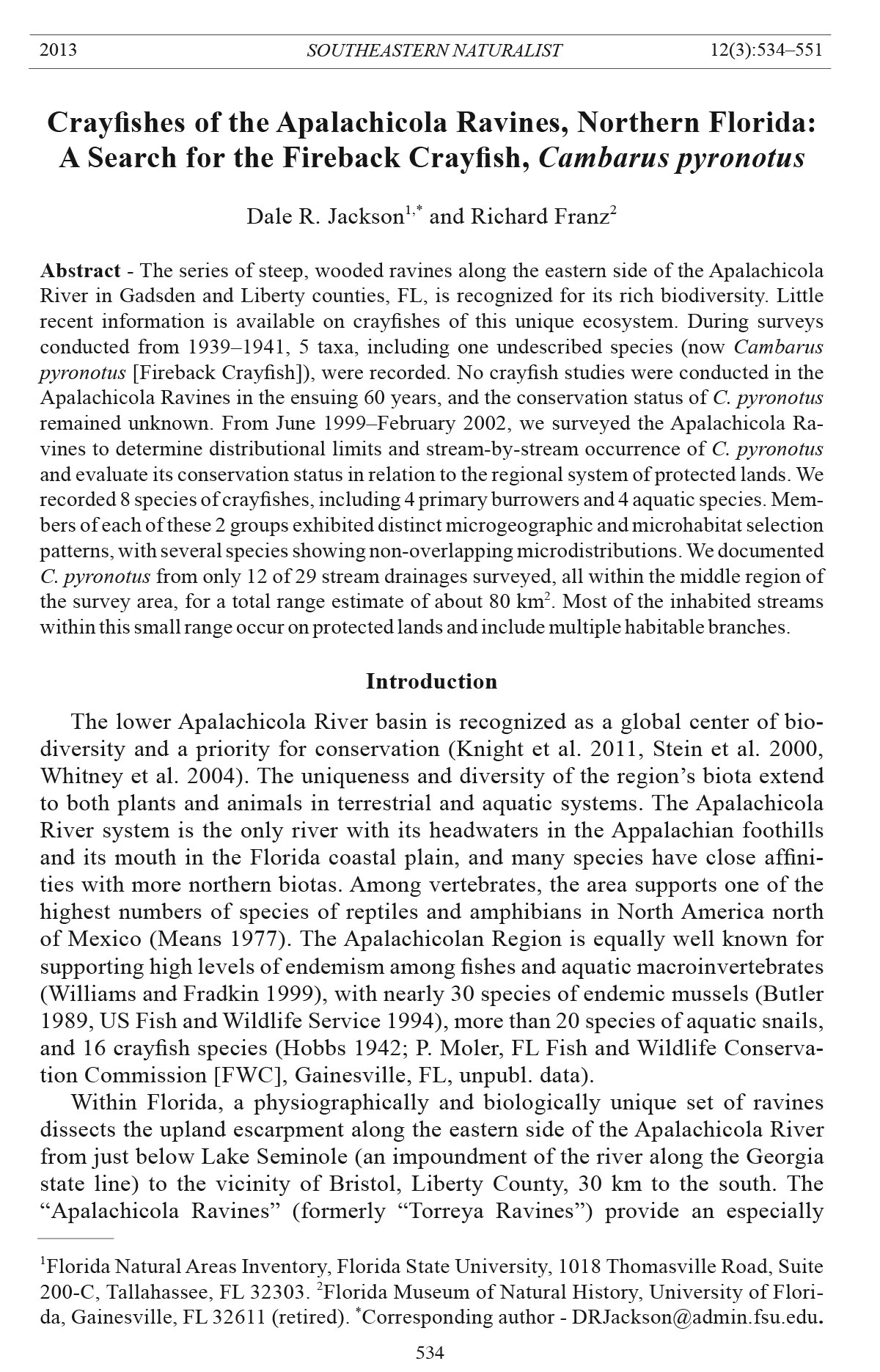
Apalachicola Ravines system (Fig. 1).
All stream systems surveyed empty into the eastern side of the Apalachicola
River, which is bordered by an escarpment as high as 60 m and an alluvial swamp
Figure 1. Map
of Apalachicola
Ravines study
area indicating
survey sites,
Florida counties,
state of
Georgia (upper
right corner of
map), and principal
stream
branches. See
Appendix 1 for
all species recorded
at each
site. Shading
= conservation
lands, hatching
= private lands
proposed for
protection.
D.R. Jackson and R. Franz
2013 Southeastern Naturalist Vol. 12, No. 3
538
of variable width (though typically much narrower than the broad floodplain west
of the river). The study area spanned 34 km in latitudinal extent, from 1 km north
of the Georgia state line (Decatur County) to 2.5 km south of Florida Highway
20 in northern Liberty County (Fig. 1). For this study, each stream system was
considered to be independent if its mouth emptied separately onto the river floodplain
(as seen on USGS 7.5’ topographic maps). The total sample included 68
sites (accessed from different points and extending 25 to >600 m each) representing
29 stream systems.
The headwater tributaries of Apalachicola Ravines stream systems are of
two types: typical gully-eroded streams that erode from the land surface, and
steepheads (Means 1975, 1981; Means and Karlin 1989; Whitney et al. 2004).
Means (1975) described the latter as perennially wet stream sources (first order)
that originate at the foot of valley headwalls. Their side-walls are very steep
(40°–90°), up to 30 m deep, and generally support mesic hardwood forests (Kwit
et al. 1998, Platt and Schwartz 1990). More xerophilic, pine-dominated vegetation
ocurrs on the upper slopes of gully-ravines. In both types of ravines, more
hydrophilic species occupy the lower slopes and valley floors. Steepheads generally
occur south of the mainstem of Sweetwater Creek (Fig. 1), with gully ravines
mostly to the north (Means 1975, Means and Karlin 1989).
Though low in volume, the flows of both gully and steephead streams are
relatively swift compared to many streams on the lower Coastal Plain, including
most in the Florida peninsula. The smaller headwater streams in the region normally
have compacted clay bottoms, which are often covered by fine sand, with
increasing amounts of silt and detritus downstream. A few regional streams cut
through calcareous sediments with exposed limestone.
Methods
Sampling
Based on characteristics of sites from which C. pyronotus had been collected
in the past, specific sampling sites were identified from 7.5’ USGS topographic
maps, aerial photographs, and field reconnaissance. Preliminary reconnaissance
of selected sites consisted of walking along first- and second-order steephead
streams to find chimneys of crayfish burrows. We classified a burrow as potentially
inhabited if it included one or more open entrances surrounded by relatively
fresh balls of mud. Fresh burrows were excavated by hand, small shovel, and
garden trowel. Cambarus pyronotus’ habit of building deep, complex burrows
among tree roots along streams rendered this task difficult and slow, yet it was
still an effective method of obtaining specimens. When possible, we excavated
burrows to the level of the local water table, where most specimens were situated.
To supplement manual excavation, we constructed 50 PVC pipe-traps similar
to those described by Norrocky (1984). These traps provided a non-invasive
sampling method with the advantage of rapid installation, minimal disruption
to habitat and no need for frequent checking. PVC traps extend burrows upward
artificially to lure movement of crayfishes past a one-way door into the trap. Each
trap consisted of a 30–40-cm length of 5-cm-(OD) PVC pipe with a flat piece of
539
D.R. Jackson and R. Franz
2013 Southeastern Naturalist Vol. 12, No. 3
aluminum wired loosely just inside one end to serve as a one-way door. We used a
rubber band to secure a piece of cheesecloth or vinyl screen-wire to the top of the
trap to prevent crayfish escape. Traps were inserted vertically to diagonally into
entrances of active burrows; this placement usually required slight enlargement
of burrow openings by hand. Trapping efforts included 6 to 14 traps at selected
sites for 1–24 nights. Though the method was marginally successful (6 crayfish/
418 trap-nights), it was later abandoned as too time-consuming because it
required return visits to a site.
We also developed a second trapping method, but we discontinued its use. For
this trap, we fashioned small single-entrance funnel-traps from standard window
screen. We inserted a small piece of cheesecloth-wrapped canned cat food as bait,
and placed the trap in a burrow that had been excavated by hand to reach the water
table. One of these traps captured a small C. diogenes, but most of the traps
were disturbed by vertebrate animals. Additionally, although lifting potential
natural cover objects (logs) may potentially yield specimens, it was ineffective in
our study. We also used a dipnet to sample for aquatic crayfish at all stream sites
visited as we surveyed for burrowing species.
Species identification
Crayfish identities were confirmed by R. Franz, mainly by comparison with
Hobbs (1942, 1981, 1989). Diagnostic features included structure of the first
pleopod of Form I males (gonopods), configuration of the annulus ventralis
of females, and distinctive color patterns. We use currently accepted scientific
names, though we acknowledge that 2 of the taxa (C. diogenes and C. striatus
[Ambiguous Crayfish]) are not monophyletic and likely represent multiple species
(Breinholt et al. 2012). A small series of voucher specimens of C. pyronotus
from No Name Creek was preserved in 70% ethanol and deposited in the invertebrate
collection of the Florida Museum of Natural History .
Results
This survey identified 8 species of crayfish: 4 taken principally from burrows,
and 4 predominantly from streams. Here we present notes on taxonomy,
morphology, microhabitat, natural history, local distribution of species by stream
drainage (Table 2), locations of primary burrowing species (Fig. 1), and species
recorded at each survey site (Appendix 1).
Survey results
Cambarus diogenes. This large species was documented in 17 of 29 streams
spanning much of the study area, although not from the 2 northernmost or 3
southernmost drainages examined. Populations were abundant in the river floodplain
and extended upstream in many stream systems to at least third order, and
occasionally, second order tributaries. Typically, C. diogenes occurred downstream
of other primary (and generally smaller) burrowers (Table 2, Fig. 1),
with minimal overlap. However, at least 2 cases of overlap (25 m or more) with
C. pyronotus (No Name Creek, Camp Torreya Creek) were noted; one of these
involved adults of both species.
D.R. Jackson and R. Franz
2013 Southeastern Naturalist Vol. 12, No. 3
540
Table 2. Summary of crayfish species by stream drainage within the Apalachicola Ravines system. Stream drainages are listed from north to south by
relative position of the mouth on the river floodplain. Unnamed streams were assigned names based on nearby physical or cultural features. For specific
collection localities, see Appendix 1. Question marks indicate tentative identifications ba sed on small juveniles. P. = Procambarus, C. = Cambarus.
Primary burrowers Stream inhabitants
C. diogenes C. striatus C. pyronotus P. rogersi C. latimanus P. spiculifer P. versutus P. latimanus
Campground Creek (CC) - - - - - - - -
Northwest Chattahoochee Creek (NC) - - - - + - - -
Chattahoochee Nature Park Creek (CN) + - - - ? - - -
Mosquito Creek (MC) - + - - + - - -
Flat Creek (FC) - + - - + + - -
Boat Ramp Creek (BR) + - - - - + - -
North of Aspalaga Landing Creek (AN) + - - - + - - -
Aspalaga Landing Creek (AL) + - - - + + - -
Short Creek (SC) + - + - + + - -
Graham Cemetery (GC) - - - - + + - -
Rock Creek (RC) + - + - + + - -
Mile 95 Creek (MF) - - + - + - - -
Indian Relic Creek North (IN) + - - - - - - -
Indian Relic Creek South (IS) + - - - - - - -
Weeping Ridge Creek (WR) + - + - + - - -
Rock Bluff Landing Creek (RB) - - + - + - - -
Long Branch (LB) + - + - + - - -
Camp Torreya Creek (CT) + - + - - - - -
Mile 90 Creek (MN) + - + - - - - -
Sweetwater Creek (SW) + - + +1 - + + -
St. Stephens Creek (SS) + - + - - + - -
No Name Creek (NN) + - + - + + - -
Beaverdam Creek (BD) - - + - - + + -
Little Sweetwater Creek (LS) - - - - - - + -
Alum Bluff Creek (AB) + - - - - - - -
Alum Bluff Seep (AS) + - - - - - - -
Kelley Branch (KB) - - - - ? - + -
St. Luke Creek (SL) - - - + - - - +
First Street Creek (FS) - - - + - - - +
1Presence based on a June 2009 collection by P. Moler.
541
D.R. Jackson and R. Franz
2013 Southeastern Naturalist Vol. 12, No. 3
All but the smallest juveniles of C. diogenes from the Apalachicola Ravines
were olive to tan in color, with red to purplish-red cheliped tips, rostrum, and
cephalic portions of the cephalothorax and abdomen; a reddish band crosses
each abdominal segment. This coloration is similar to the concolorous pattern
noted in Georgia specimens by Hobbs (1981), but is distinctly different from
the pattern observed in other northwestern Florida populations (R. Franz, pers.
observ.), which supports suggestions (Breinholt et al. 2012, Hobbs 1942) that the
C. diogenes group is in need of review.
Cambarus latimanus. Dipnet sampling yielded many, mostly juvenile C. latimanus
from first-order and small second-order streams within at least 13 stream
systems, but we did not detect the species in the 7 southernmost ravines. We
observed a few adult individuals in-stream, and others were taken from burrows,
including a Form I male on 22 March 2001 and an adult female on 3 April 2003.
Cambarus pyronotus. This species was found at 21 sites within 12 drainages,
including streams both north and south of the original boundaries of Torreya
State Park. No C. pyronotus were collected from the 8 northernmost and 6 southernmost
streams in the study area. We supplemented our observations with earlier
unpublished sightings (all from within our determined range); P. Moler collected
the species during the early 1990s from St. Stephens Creek (P. Moler, FWC,
Gainesville, FL, unpubl. data; Appendix 1), K. Studenroth captured several
specimens in pitfall traps associated with drift fences during a 1994–1995 herpetological
survey of the Rock Creek addition to Torreya State Park (K. Studenroth,
Northwest FL Environmental Conservancy [NWFLEC], Marianna, FL, unpubl.
data), and S. Humphrey provided behavioral notes to accompany a photograph
taken in 1978 (S. Humphrey, FL Museum of Natural History [FLMNH], Gainesville,
FL, unpubl. data). Though often abundant where found, C. pyronotus may
inhabit a range that extends no more than 13 km from north to south and 8 km
from east to west.
Observations confirm that C. pyronotus is a primary burrower restricted to
first- and second-order tributaries flowing through closed-canopy hardwood
forests. Crayfishes of all demographic classes were removed from burrows constructed
within a few centimeters to several meters from stream edges. Burrow
size and complexity generally increased with crayfish size. Burrows of small juveniles
were relatively simple, often with a single entrance. Those of adults had
one to 5 entrances, with tunnels extending laterally to vertically for as much as a
meter or more in each direction. Burrow depth varied with the upslope distance of
the burrow entrance from the stream; thus, depths ranged from a few centimeters
(typical of small juveniles that burrowed just above the stream) to an estimated
1.5 m (too deep and with too many plant roots to be excavated). All burrows had
at least one tunnel leading to a chamber that reached groundwater. Most crayfishes
were encountered only after digging to this chamber .
Cambarus striatus. The current study collected C. striatus (name subject to
future revision: Breinholt et al. 2012) only from burrows in stream systems north
of those inhabited by C. pyronotus. Specifically, C. striatus occurs along tributaries
of Mosquito and Flat creeks, both in Gadsden County, just north of Liberty
D.R. Jackson and R. Franz
2013 Southeastern Naturalist Vol. 12, No. 3
542
County. These are the only relatively large and complex drainages among the 8
streams surveyed north of Short Creek, the northernmost creek confirmed in this
study to support C. pyronotus. On 10 November 2000 along Flat Creek, tiny but
free young were observed cohabiting in burrows with 2 adult females.
Procambarus leonensis. Within the current study area, this species was captured
with dipnets only in the 2 southernmost streams (St. Luke and First Street
creeks). Because these 2 ravines have lower topographic profiles as a result of
sand overburden reduction from Pleistocene erosion, they qualify only marginally
as true Apalachicola Ravines.
Procambarus rogersi. This primary burrower was excavated along the two
southernmost streams in the present survey, the same ones that produced the
only P. leonensis collected. These sites are separated from the southernmost occurrence
of C. pyronotus by 7 km. Subsequent to the current survey, P. Moler
collected P. rogersi at a site along lower Sweetwater Creek (SW-2) during June
2009 (P. Moler, FWC, Gainesville, FL, unpubl. data).
Procambarus spiculifer. Dipnetting yielded mostly small specimens from
second-order and, very rarely, first-order tributaries in 10 drainages that spanned
much of the study area, though none south of the range of C. pyronotus. Our
surveys were concentrated in shallower first- and second-order streams, and we
did not sample the lower portions of other systems where P. spiculifer may also
be present
Procambarus versutus. We found this species in only 4 drainages, all in the
southern half of the study area. We located none north of the large Sweetwater
Creek system that physiographically separates steephead-dominated from gullydominated
drainages. Form I males were taken on 16 June 2000, 18–19 September
1999, and 6 November 1999.
Life-history data for Cambarus pyronotus
The current survey revealed that C. pyronotus maintained at least some activity
year-round, though burrows were frequently plugged during cold weather and
during droughts. Individuals collected during colder months (December–February)
were often lethargic until handled. Although numbers of burrows were not
recorded, the species was clearly abundant at some sites and rare at others. We
obtained crayfish only from burrows and never observed surface activity, though
there is evidence that the latter occurs at least occasionally. Studenroth intercepted
both immature and mature specimens, including an ovigerous female (2 April
1995), at drift fences placed adjacent to streams during a herpetological survey of
Torreya State Park in May–June 1994 and April 1995 (K. Studenroth, NWFLEC,
unpubl. data). Humphrey photodocumented abundant and active C. pyrontus on
the surface, during mid-morning observations in 1978 (S. Humphrey, FLMNH,
Gainesville, FL, unpubl. data).
Although not recorded for all specimens, data revealed the following demographic
classes by dates—Form I males (including one freshly molted): 16–17
June and 19 October 1999; Form II males: 9 Janauary, 9 March, 21 May, and 4–6
and 17 June 2000; ovigerous females: 2 April 1995 (K. Studenroth, NWFLEC,
543
D.R. Jackson and R. Franz
2013 Southeastern Naturalist Vol. 12, No. 3
unpubl. data), 5 June 1999; female with free young in burrow: 16 June 2000; nonovigerous
females: 16 April 2000, 23 May 2001, 4–6 June 1999, 11 August 2001,
24 and 30 September 1999, and 17 and 23 November 1999; and juveniles (< 4 cm
total length): 9 January, 9 March, and 16 April 2000, 23 May 2001, 4–6 and 17
June 2000, and 18 September 1999. An increase in intensity of red pigmentation
with age (size) was conspicuous; small juveniles typically ranged from brownish
to pale salmon, which changed to bold orange-red to red in adults.
The ovigerous female collected 5 June 1999 at No Name Creek carried 38
orange-colored eggs; diameters of 5 eggs averaged 2.3 mm. The burrow was located
in the bank 2.1 m from a small, sand-bottomed tributary with a maximum
water depth of 3 cm and width of 1.3 m; the burrow opened 30 cm above water
level. Water and burrow-mud temperatures were 23 °C. The 2 to 3 dozen tiny
young discovered sharing a female’s burrow on 16 June 2000 at Camp Torreya
Creek were ≈6 mm in total length.
Discussion
The range of C. pyronotus, as delimited by this study, consists of a series of
small stream systems with a latitudinal extent of 13 km, longitudinal extent of 8
km, and an area of 80 km2. These parameters indicate that this species is one of
the most geographically restricted surface (non-stygobitic) crayfishes in North
America (NatureServe 2012, Taylor et al. 2007). Interestingly, this range is bisected
by a geological break described by Means (1998) as the most important
in the Panhandle of Florida. Streams north of the break (at Sweetwater Creek)
are gully-eroded ravines formed in Miocene clays, sands, and gravels, whereas
streams to the south are steephead valleys developed in deep, porous Plio-Pleistocene
sand deposits (Means 1998).
Our life-history observations supplement those provided by Bouchard (1978),
who recorded ages and sexes of the type series (Hobbs collection) as follows.
The sole Form I male (holotype) was collected 28 November 1941, along with 8
females, one of which was listed as a juvenile. The sample also included a Form
II male collected 8 April 1941; 7 juvenile males collected on 3 dates (17 March
1939, 13 December 1939, and 8 April 1941); an adult female collected 8 April
1941; and 4 juvenile females collected on 2 dates (17 March 1939 and 8 April
1941). Table 3 depicts minimal seasonal occurrence of demographic classes
Table 3. Monthly distributions of observed demographic classes of Cambarus pyronotus (+), including
data from Hobbs’1939–1941 collection (H) as presented b y Bouchard (1978).
Jan Feb Mar Apr May Jun Jul Aug Sep Oct Nov Dec
♂ I + + H
♂ II + + H + +
♀, ovigerous + +
♀ with young +
♀, non-ovigerous +/H + + + + +/H
Juvenile less than 4 cm + +/H +/H + + + H H
D.R. Jackson and R. Franz
2013 Southeastern Naturalist Vol. 12, No. 3
544
based on our combined data sets, although neither study attempted to spread
survey efforts evenly across the year. The small number of ova and neonates
found with reproductive females in our study, if representative of entire clutches,
contrasts with parameters normally seen in crayfishes, but larger samples are
needed to corroborate this potential difference.
Type locality of Cambarus pyronotus
Some confusion exists about the type locality of C. pyronotus as well as
Hobbs’ other collecting sites as listed by Bouchard (1978). The first site, a ravine
in the northern part of Torreya State Park (TSP), was mentioned by Hobbs (1942)
and must be either our Mile 95 Creek or the lowermost tributary of Rock Creek
(both of which support the species). The second site, Rock Bluff, is described as a
deep ravine in TSP. However, Rock Bluff, as shown on topographic maps, is 3 km
southeast of the original park, at the headwaters of the Rock Creek drainage; our
Rock Bluff Landing Creek is a deep ravine emerging on the river at Rock Bluff
Landing, but this drainage lies immediately south of the original park. Whether
Hobbs meant this creek or a large tributary of Rock Creek that occupies much
of the eastern portion of the original park is uncertain, although the latter is suspected.
The third and fourth sites listed by Bouchard (1978) are ravines south of
Indian Lodge and south of Indian Ridge, both in TSP. In all likelihood, Bouchard
mistakenly used the word “lodge” for “ridge” and these represent the same site.
Because it produced the only Form I male available to Hobbs, Bouchard selected
this as the type locality. However, he then declared this creek to be Beaver Dam
Creek, but the only creek known locally by that name (though more often spelled
Beaverdam) lies 8 km south of TSP. Clearly, the description of the type locality
as lying south of Indian Ridge in TSP and possessing a waterfall can only be the
unnamed creek that we herein call Weeping Ridge Creek, after the park’s Weeping
Ridge Campground situated above its northern slope. Cambarus pyronotus
was readily found here in this study, and hence we redesignate the type locality
as Weeping Ridge Creek in Torreya State Park, Liberty County, FL.
Microdistributional patterns
The Apalachicola Ravines study area supports a crayfish fauna that includes 4
primary burrowing species and 4 principally aquatic species; the ranges of some
appear to be parapatric to the restricted range of C. pyronotus. Although our principal
goal was to determine the extent of occurrence of C. pyronotus, our data
suggest a number of distributional relationships among the 8 species. Foremost
among them are the essentially non-overlapping distributions of the three smaller
primary burrowing species (C. pyronotus, C. striatus, and P. rogersi) that occupy
headwater tributaries within the Apalachicola Ravines. Along first- and smaller
second-order streams, we found C. striatus only in drainages north of the range
of C. pyronotus. This observation supports the suggestion of Hobbs (1942), who
collected C. striatus, (which he referred to as C. floridanus) only from seepages
and creeks along the Chipola River (an Apalachicola River tributary) and Ochlockonee
River (just east of the Apalachicola), but who speculated that it might
545
D.R. Jackson and R. Franz
2013 Southeastern Naturalist Vol. 12, No. 3
eventually be found in some small tributaries of the Apalachicola River, though
perhaps not sympatrically with C. pyronotus.
Similarly, we collected P. rogersi only from drainages south of the range of
C. pyronotus, although Moler found it in Sweetwater Creek, but downstream
of tributaries inhabited by C. pyronotus. The much larger C. diogenes inhabits
the entire study area (and beyond) but mostly occurs in floodplain habitat and
the lower portions of stream drainages, exhibiting only minimal within-stream
overlap with the 3 smaller species.
Our data for principally aquatic crayfishes are less comprehensive but suggest
potential microgeographic differences similar to those noted for primary burrowers.
Within the study area, C. latimanus, P. versutus, and P. leonensis appear to
have complementary distributions. Procambarus leonensis was collected from
only the 2 southernmost streams, as was the primary burrower P. rogersi. Only
4 streams, all in the southern half of the area (Sweetwater Creek and 3 smaller
drainages to the south), were found to support P. versutus. In contrast, C. latimanus
occupies at least 12 of 19 streams north of Sweetwater Creek, but was found
in only one to the south (No Name Creek, which may lack P. versutus). Thus,
we observed no instances of co-occurrence of these 3 species. Procambarus
spiculifer, on the other hand, shared multiple streams with both C. latimanus and
P. versutus, although all P. spiculifer captured in first- (infrequent) and secondorder
(more frequent) streams were juveniles. Hobbs (1942) also found the local
distributions of P. versutus and C. latimanus in the Apalachicola Ravines to be
complementary, and noted that P. versutus penetrated further upstream than
P. spiculifer in shared drainages.
Conservation status of the Apalachicola Ravines crayfish fauna
Because of land acquisition efforts by the State of Florida and The Nature
Conservancy, a substantial portion of the Apalachicola Ravines ecosystem is now
protected. Torreya State Park was established in 1944 with the protection of 430
ha that included a few smaller ravines, but a series of land acquisitions begun
in 1990 (including much of the Rock Creek and Sweetwater Creek drainages)
vastly expanded its size to 5558 ha. The Nature Conservancy began acquiring
lands south of the original park for its Apalachicola Bluffs and Ravines Preserve
(ABRP) in 1982 and now manages 2548 ha (Florida Natural Areas Inventory
2012). Most of the range of C. pyronotus is encompassed by these combined protected
lands. North of the range of C. pyronotus, much of the remaining private
land bordering the river and extending to within 2.5 km of the Georgia border
is under consideration for acquisition by the state (Apalachicola River Florida
Forever project), although funding to secure this land remains problematic. The
city of Chattahoochee owns a 51-ha nature park with two small ravines located
2 km south of the Georgia border. Despite these efforts, the two large drainages
at the northern end of our study area, Mosquito and Flat creeks, remain unprotected,
although portions are under consideration for state protection. Thus,
among primary burrowers, most of the range of C. pyronotus is now protected;
D.R. Jackson and R. Franz
2013 Southeastern Naturalist Vol. 12, No. 3
546
many of these same lands also support C. diogenes. Cambarus striatus is virtually
unprotected in this region, as may be P. rogersi, although the latter might
occur on protected lands elsewhere in Florida. Among stream forms, P. versutus,
P. spiculifer, and C. latimanus all occur in several protected Apalachicola Ravines
stream systems; P. leonensis does not, but is more widely distributed in
lentic habitats elsewhere in the Florida Panhandle.
It is noteworthy that within one sampled stream system (Graham Cemetery
Creek), crayfish burrows as well as aquatic crayfishes appeared to be absent from
first-order streams exhibiting extensive disturbance from rooting and wallowing
by Sus scrofa L. (Feral Hogs). Aquatic crayfish did occur in undisturbed higher
order reaches of Graham Cemetery Creek. Headwaters of stream systems immediately
north and south of this stream support C. pyronotus as well as aquatic
species, which underscores the value of bringing the remaining private holdings
within the Apalachicola Ravines system into public or conservation ownership,
where threats such as disturbance by Feral Hogs can be addresse d. Private lands
important for acquisition include stream systems occurring both north and south
of the range of C. pyronotus. However, even on protected lands, Feral Hogs constitute
a continuing threat that requires regular control, as evidenced by increased
hog populations on the ABRP in 2003–2004. Even if eliminated within protected
areas, hogs readily reinvade from adjacent private lands. For example, although
SW-1 (on ABRP) still supported a robust C. pyronotus population in March 2004,
evidence of hog rooting in the streamside microhabitat used by this crayfish
raises concerns.
On remaining private lands, commercial silviculture threatens the ecological
integrity of inhabited streams. Recent clearcutting of timber along Short Creek
at the time of our study produced erosion and siltation of that stream system,
which supports the northernmost known population of C. pyronotus. Similarly,
Means and Studenroth (1995) noted heavy sedimentation in the middle reaches of
Rock Creek, the second largest drainage supporting the species, as a result of mechanical
disturbance associated with silviculture, excavation of borrow pits, and
construction of roads in the uplands. Thus, even though land protection efforts
have secured a substantial portion of the Apalachicola Ravines ecosystem that
supports C. pyronotus and a variety of other rare species, long-term conservation
efforts will require continued vigilance and action by land managers charged with
preservation of this globally significant biota.
Acknowledgments
We thank The Nature Conservancy, especially Rick Studenmund and Jon Blanchard,
for funding our field work. The St. Joe Company, The Nature Conservancy, and the Florida
Department of Environmental Protection Division of Recreation and Parks granted
permission to conduct research on their lands. Grayal Farr, Karl Studenroth, and Mike
Wilson provided invaluable field assistance. Dick Bartlett, Steve Humphrey, Barry Mansell,
Bruce Means, Paul Moler, and Karl Studenroth shared data and photographs. Bruce
Means and Paul Moler reviewed the manuscript, and Mike O’Brien and David Almquist
547
D.R. Jackson and R. Franz
2013 Southeastern Naturalist Vol. 12, No. 3
assisted with figure preparation. The Florida Fish and Wildlife Conservation Commission,
courtesy of Stasey Whichel, supported publication through administration of a State
Wildlife Grant funded by the US Fish and Wildlife Service.
Literature Cited
Berner, L., and M.L. Pescador. 1988. The Mayflies of Florida. Revised edition. University
Press of Florida, Gainesville, FL. 352 pp.
Bouchard, R.W. 1978. Taxonomy, ecology, and phylogeny of the subgenus Depressicambarus,
with the description of a new species from Florida and redescriptions of
Cambarus graysoni, Cambarus latimanus, and Cambarus striatus (Decapoda: Cambaridae).
Bulletin of the Alabama Museum of Natural History 3:27–60.
Breinholt, J.W., M.L. Porter, and K.A. Crandall. 2012. Testing phylogenetic hypotheses
of the subgenera of the freshwater crayfish genus Cambarus (Decapoda: Cambaridae).
PLoS ONE 7(9): e46105. Available online at doi:10.1371/journal.pone.0046105.
Butler, R.S. 1989. Distributional records for freshwater mussels (Bivalvia: Unionidae)
in Florida and south Alabama, with zoogeographic and taxonomic notes. Walkerana
3:239–261.
Carr, A.F. 1940. A contribution to the herpetology of Florida. University of Florida Biological
Science Series 3(1):1–118.
Florida Department of Environmental Protection. 2011. Florida Forever five-year plan.
Available online at http://www.dep.state.fl.us/lands/FFAmual. Accessed 26 October
2011.
Florida Natural Areas Inventory. 2012. Florida Conservation Lands database. Available
online at http://www.fnai.org/conservationlands.cfm. Accessed 17 December 2012.
Franz, R., 1994. Red-back Crayfish. Pp. 218–220, In M. Deyrup and R. Franz (Eds.).
Rare and Endangered Biota of Florida, Volume IV: Invertebrates. University Press of
Florida, Gainesville, FL. 798 pp.
Franz, R., and S.E. Franz. 1990. A review of the Florida crayfish fauna, with comments
on nomenclature, distribution, and conservation. Florida Scientist 53:286–296.
Harper, R.M. 1914. Geography and vegetation of northern Florida. Florida Geological
Survey Annual Report 6:171–451.
Harris, S.C., M.L. Pescador, and A.K. Rasmussen. 1998. Two new species of microcaddisflies
(Trichoptera: Hydroptilidae) from northern Florida. Florida Entomologist
81:221–224.
Hobbs, H.H., Jr. 1942. The crayfishes of Florida. University of Florida Publication, Biological
Science Series 3(2):1–179.
Hobbs, H.H., Jr. 1981. The crayfishes of Georgia. Smithsonian Contributions to Zoology
(381):1–549.
Hobbs, H.H., Jr. 1989. An illustrated checklist of the American crayfishes (Decapoda:
Astacidae, Cambaridae and Parastacidae). Smithsonian Contributions to Zoology
(480):1–236.
Hobbs, H.H., Jr., and C.W. Hart, Jr. 1959. The freshwater decapod crustaceans of the
Apalachicola drainage system in Florida, southern Alabama, and Georgia. Bulletin of
the Florida State Museum 4(5):145–191.
Hubbell, T.H. 1936. A monographic revision of the genus Ceuthophilus. University of
Florida Publication, Biological Science Series 2:1–151.
Knight, G.R., J.B. Oetting, and L. Cross (Eds.). 2011. Atlas of Florida’s Natural Heritage—
Biodiversity, Landscapes, Stewardship, and Opportunities. Institute of Science
and Public Affairs, Florida State University, Tallahassee, FL. 161 pp.
D.R. Jackson and R. Franz
2013 Southeastern Naturalist Vol. 12, No. 3
548
Kurz, H. 1933. Northern disjuncts in northern Florida. Florida Geological Survey Annual
Report 23/24:49–53.
Kwit, C., M.W. Schwartz, W.J. Platt, and J.P. Geaghan. 1998. The distribution of tree
species in steepheads of the Apalachicola River bluffs, Florida. Journal of the Torrey
Botanical Society 125:309–318.
Means, D.B. 1975. Competitive exclusion along a habitat gradient between two species
of salamanders (Desmognathus) in western Florida. Journal of Biogeography
2:253–263.
Means, D.B. 1977. Aspects of the significance to terrestrial vertebrates of the Apalachicola
River drainage basin, Florida. Florida Marine Research Publ ications 26:23–67.
Means, D.B. 1981. Steepheads: Florida’s little-known canyonlands. ENFO 81(6):1–4.
Means, D.B. 1998. Amphibians and reptiles of Apalachicola Bluffs and Ravines Preserve,
The Nature Conservancy, Liberty County, FL. Report submitted to The Nature
Conservancy, Bristol, Fl.
Means, D.B., and A.A. Karlin. 1989. A new species of Desmognathus from the eastern
Gulf Coastal Plain. Herpetologica 45:37–46.
Means, D.B., and K.R. Studenroth, Jr. 1995. Amphibians and reptiles of Torreya State
Park (with special emphasis on the Rock Creek tract). Report submitted to Torreya
State Park. Coastal Plains Institute, Tallahassee, FL.
NatureServe. 2012. NatureServe Explorer: An online encyclopedia of life [web application].
Version 7.1. NatureServe, Arlington, VA. Available online at http://www.natureserve.
org/explorer. Accessed 15 November 2012.
Norrocky, M.J. 1984. Burrowing crayfish trap. Ohio Journal of Science 84 :65–66.
Platt, W.J., and M.W. Schwartz. 1990. Temperate hardwood forests. Pp. 194–229, In R.
Myers and J. Ewel (Eds.). Ecosystems of Florida. University of Central Florida Press,
Orlando, FL. 765 pp.
Stein, B.A., L.S. Kutner, and J.S. Adams (Eds.). 2000. Precious Heritage: The Status of
Biodiversity in the United States. Oxford University Press, UK. 416 pp.
Taylor, C.A., G.A. Schuster, J.E. Cooper, R.J. DiStefano, A.G. Eversole, P. Hamr, H.H.
Hobbs III, H.W. Robison, C.E. Skelton, and R.F. Thoma. 2007. A reassessment of the
conservation status of crayfishes of the United States and Canada after 10+ years of
increased awareness. Fisheries 32(8):372–389.
US Fish and Wildlife Service. 1994. Endangered and threatened wildlife and plants; proposed
endangered status for five freshwater mussels and proposed threatened status
for two freshwater mussels from Eastern Gulf Slope drainages of Alabama, Florida,
and Georgia. Federal Register 59(148):39,524–39,532.
Whitney, E., D.B. Means, and A.R. Rudloe. 2004. Priceless Florida: Natural Ecosystems
and Native Species. Pineapple Press, Melbourne, FL. 423 pp.
Williams, J.D., and A. Fradkin. 1999. Fusconaia apalachicola, a new species of freshwater
mussel (Bivalvia: Unionidae) from precolumbian archaeological sites in the
Apalachicola basin of Alabama, Florida, and Georgia. Tulane Studies in Zoology and
Botany 31:51–62.
549
D.R. Jackson and R. Franz
2013 Southeastern Naturalist Vol. 12, No. 3
Appendix 1. Collection sites for crayfish within the Apalachicola Ravines system; all sites except
Campground Creek are in Florida stream drainages and are listed from north to south by relative
position of stream mouth on the river floodplain. Approximate midpoints of latitude and longitude
are provided for stream stretches covering several hundred meters, and for groups of subsites
(lower case letters following site number; typically these comprise nearby first-order and adjacent
second-order streams) sufficiently close to be considered a single site. Species collected follow
site coordinates and are indicated by 2-letter acronyms (absence of acronyms indicates no crayfish
collected at site). Primary burrowers: CD = Cambarus diogenes, CS = Cambarus striatus, CP =
Cambarus pyronotus, PR = Procambarus rogersi. Aquatic inhabitants: CL = Cambarus latimanus,
PS = Procambarus spiculifer, PV = Procambarus versutus, PL = Procambarus leonensis.
Campground Creek, Decatur County, GA.
CC-1: 30°42'57"N, 84°50'59"W
Northwest Chattahoochee Creek, Gadsden County
NC-1: 30°42'31"N, 84°50'56”W; CL
Chattahoochee Nature Park Creek, Gadsden County
CN-1: 30°41'48"N, 84°51'01"W; CD, CL?A
Mosquito Creek, Gadsden County
MC-1: 30°39'39"N, 84°49'31"W; CS, CL
Flat Creek, Gadsden County
FC-1: 30°39'11"N, 84°48'29"W; CS, PS
FC-2: 30°39'33"N, 84°49'49"W; CS?, CL, PS
FC-3: 30°37'52"N, 84°48'01"W; CS
Boat Ramp Creek, Gadsden County
BR-1: 30°37'29"N, 84°54'02"W; CD, PS
North of Aspalaga Landing Creek, Gadsden County
AN-1: 30°37'03"N, 84°54'21"W; CD, CL
Aspalaga Landing Creek, Gadsden County
AL-1: 30°36'55"N, 84°54'27"W; CD, CL, PS
Short Creek, Liberty County
SC-1: 30°34'25"N, 84°54'15"W; CP, CL, PS
SC-2: 30°36'16"N, 84°54'24"W; CL
SC-3: 30°36'16"N, 84°54'35"W; CL
SC-4: 30°36'01"N, 84°55'03"W; CD
SC-5: 30°36'10"N, 84°54'11"W; CL
SC-6: 30°35'06"N, 84°54'43"W; CL, PS
SC-7: 30°34'19"N, 84°54'02"W; CP, CL, PS
Graham Cemetery Creek, Liberty County
GC-1:30°34'44"N, 84°55'26"W; CL
GC-2:30°34'52"N, 84°55'22"W
GC-3:30°35'05"N, 84°55'15"W; CL, PS
Rock Creek, Liberty County
RC-1: 30°33'53"N, 84°55'37"W; CP
RC-2: 30°33'47"N, 84°55'27"W; CP
RC-3: 30°34'17"N, 84°56'07"W; CD?
RC-4: 30°33'04"N, 84°54'50"W; CP, CL
RC-5: 30°33'00"N, 84°55'00"W; CP, CL
RC-6: 30°33'52"N, 84°55'30"W; PS
RC-7: 30°33'51"N, 84°55'30"W; CD, CL
D.R. Jackson and R. Franz
2013 Southeastern Naturalist Vol. 12, No. 3
550
Mile 95 Creek, Liberty County
MF-1: 30°34'32"N, 84°56'50"W; CP, CL
Indian Relic Creek North, Liberty County
IN-1: 30°34'25"N, 84°57'01"W; CD
Indian Relic Creek South, Liberty County
IS-1: 30°34'15"N, 84°56'57"W; CD
Weeping Ridge Creek, Liberty County
WR-1: 30°33'53"N, 84°57'00"W; CP
WR-2: 30°33'52"N, 84°57'09"W; CD, CL
Rock Bluff Landing Creek, Liberty County
RB-1: 30°33'04"N, 84°56'57"W; CP, CL
Long Branch, Liberty County
LB-1 ab: 30°32'55"N, 84°57'50"W; CD, CP, CL
Camp Torreya Creek, Liberty County
CT-1: 30°32'43"N, 84°58'00"W; CD, CP
Mile 90 Creek, Liberty County
MN-1: 30°32'18"N, 84°58'21"W; CD, CP
Sweetwater Creek, Liberty County
SW-1 abc: 30°32'04"N, 84°57'54"W; CD, CP, PS
SW-2: 30°31'32"N, 84°58'04"W; CDB, PRB, PS
SW-3: 30°32'02"N, 84°54'16"W; CP, PV
SW-4: 30°31'02"N, 84°54'05"W; CP, PV
SW-5: 30°30'38"N, 84°54'07"W; PV
SW-6: 30°29'33"N, 84°54'08"W; PV
SW-7: 30°29'37"N, 84°56'32"W; CP, PV
St. Stephens Creek, Liberty County
SS-1 abcdef: 30°30'47"N, 84°58'40"W; CP, PS
SS-F: 30°31'04"N, 84°59'04"W; CD
No Name Creek, Liberty County
NN-1: 30°30'00"N, 84°58'50"W; CD, CP, CL, PS
Beaverdam Creek, Liberty County
BD-1: 30°29'21"N, 84°57'45"W; CP, PS, PV
BD-2: 30°29'12"N, 84°58'12"W; CP, PV
BD-3: 30°29'29"N, 84°58'18"W; CP
Little Sweetwater Creek, Liberty County
LS-1 abcdef: 30°28'44"N, 84°57'10"W; PV
LS-2: 30°28'28"N, 84°56'16"W; PV
LS-3: 30°28'49"N, 84°58'41"W
LS-4: 30°28'55"N, 84°56'34"W; PV
LS-5: 30°28'32"N, 84°58'9"W
LS-6: 30°28'36"N, 84°58'11"W; PV
LS-7: 30°28'17"N, 84°58'36"W
LS-8: 30°28'11"N, 84°58'34"W; PV
Alum Bluff Creek, Liberty County
AB-1: 30°27'44"N, 84°59'25"W; CD
Alum Bluff Seep, Liberty County
AS-1: 30°27'35"N, 84°59'31"W; CD
AS-F: 30°27'31"N, 84°59'31"W; CD
551
D.R. Jackson and R. Franz
2013 Southeastern Naturalist Vol. 12, No. 3
Kelley Branch, Liberty County
KB-1: 30°27'34"N, 84°58'9"W; CL?, PV
KB-2: 30°28'5"N, 84°57'57"W; PV
KB-3: 30°28'7"N, 84°58'7"W; PV
KB-4: 30°27'56"N, 84°58'33"W; PV
KB-5: 30°27'20"N, 84°58'29"W; PV
St. Luke Creek, Liberty County
SL-1: 30°26'30"N, 84°58'42"W
SL-2: 30°26'30"N, 84°58'33"W; PR, PL
First Street Creek, Liberty County
FS-1: 30°24'40"N, 84°59'17"W; PR, PL
AQuestion marks indicate tentative identification based on small juveniles.
BBased on June 2009 collection by P.E. Moler.


 The Southeastern Naturalist is a peer-reviewed journal that covers all aspects of natural history within the southeastern United States. We welcome research articles, summary review papers, and observational notes.