Antiquarians, Archaeologists, and Viking Fortifications
Ben Raffield*
Abstract - This article addresses the depth of our knowledge regarding Viking fortifications in England, Scotland, and
Wales, assessing perceptions of them as a monument type. This sudy includes the investigation of antiquarian influences
upon the interpretation of these sites. It is suggested that archaeological knowledge of these monuments is largely fragmentary,
and that in some cases, current understanding can in fact be based on interpretations dating back as far as the 17th
or even 16th century. Additionally, it is proposed that Viking fortified sites do not exist with any form of homogeneity as a
monument type. The research process of these investigations, findings, and two case studies are summarized. The article
discusses the current state of knowledge regarding Viking fortifications and suggests how the study of them should proceed.
*Department of Archaeology, University of Aberdeen, St. Mary's building, Elphinstone Road, Aberdeen, AB24 3UF, UK;
B.Raffield@Abdn.ac.uk.
Introduction:
The Viking Age and the “Invasion” of Britain
Throughout much of the period known as the
“Viking Age”, Scandinavian groups arrived to raid
and campaign on British soil. These forces required
a safe place to overwinter or situate themselves
while under threat from indigenous armies and
populations. In England, they first “appear to have
made use of natural islands, such as … Sheppey and
Thanet” (Richards 2004:38) and continued to do so
throughout the 9th, 10th, and 11th centuries. The 991
Battle of Maldon, Essex, supposedly involved the
honorable but foolish act by Ealdorman Byrhtnoth
of “[giving] too much room to those wretches”
(Griffiths 1991:55) and allowing the opposing Viking
army to cross from their base on Northey Island
to engage in a “fair fight” on the Anglo-Saxon-held
shore. Viking armies are also recorded as constructing
purpose-built fortifications, with the locations of
these occasionally being recorded with some accuracy.
Despite this, there have been limited attempts
to identify and excavate these sites, though in the
past few decades some inroads have been made with
the unexpected location of the Viking overwintering
camp at Repton, Derbyshire, used during the period
873–874 (Biddle and Kjølbye-Biddle 1992, 2001).
Current work being undertaken by the universities
of York and Sheffield at Torksey, Lincolnshire, the
location of the same army’s overwintering in the previous
year, has identified evidence likely representative
of the Viking occupation, though the majority
of the discoveries is thus far confined to small finds
recovered largely through metal-detecting activities
(University of York 2012). The evidence recovered
to date from Torksey (Blackburn 2002:92–93, 2011)
and the finds excavated at Woodstown in Ireland
(Russell et al. 2007) have revealed tentative evidence
that occupation and fortification sites may be
linked with local, regional, and national economies.
At Woodstown, for example, 208 lead weights have
been found, which suggests an intrinsic relationship
between the site and the wider economy—the presence
of hacksilver also presents a definitive Scandinavian
signature, which is not widely seen in Irish
contexts (Russell et al 2007:25). Similar finds have
also been recovered at Torksey (Blackburn 2002),
suggesting that Viking overwintering camps or fortifications
may be significantly more enigmatic than
previously perceived.
Though the scale of Viking “invasion” and the
size of the armies involved has been subject to debate
in the past, most significantly by Sawyer (1971)
and Brooks (1979), this is still a divided subject.
While Clarke (1999:40) states that armies probably
numbered “hundreds rather than thousands”, “it
does seem hard to reconcile contemporary accounts
of the largest Viking forces with numbers below the
low thousands” (Williams 2008:195). By attempting
to locate sites associated with conflict, such as
fortifications, we can begin to accommodate the
“violent” side of Viking Age life within our current
views of Viking Age society, which have been
augmented by development-instigated excavation
at “domestic” sites such as Coppergate and Dublin.
If we ignore the “military” aspects of Viking life,
then we are in danger of creating a pacified past by
which only the activities attributed to the more sociably
agreeable side of Viking life are sufficiently
understood. Indeed, it has already been argued that
we have “lost sight of the violent side of the Vikings”
(Price 1991:7), something that has only begun
to change in the last few years. Our substantial
knowledge of life in the Roman army, for example,
is taken from extensive excavations at military
installations and fortifications such as Inchtuthil
Legionary Fortress and Housesteads Fort (Pitts and
St. Joseph 1985; Rushworth 2009a, b). If these more
ephemeral monuments dating from the Viking Age
could be identified, then it may be possible to gain
a clearer picture and greater understanding of how
2013 Journal of the North Atlantic No. 20:1–29
2 Journal of the North Atlantic No. 20
the peoples that built and occupied them lived and
the impact that they were to have in the countries
within which they were operating. A desktop study
was therefore undertaken to assess the depth of our
knowledge regarding Viking fortifications and to assess
our perceptions of them as a monument type.
The State of Knowledge
Available literature on the subject, as has been
alluded to, is relatively scant. Conflict in the Viking
Age is broadly covered as part of general historical
and archaeological texts (e.g., Forte et al. 2005, Hall
2007, Logan 2005, Richards 2004, Williams 2008,
among others), though detailed case studies are
understandably lacking. The discussion of fortifications
within these studies is also therefore limited
to references to sites recorded in The Anglo-Saxon
Chronicle or those that have been tentatively identified
in the field, as will be seen below. It is worth
noting that there are no synthesized archaeological
studies dealing with Viking Age fortifications
across Britain at present, suggesting that there is
a gap in our knowledge that requires filling if we
are to understand how Viking armies operated on a
day-to-day basis. Various authors discuss the subject
of fortifications as part of a wider agenda (Abels
1997, Haslam 2005, Richards 2004, Williams 2008),
though they are not addressed in any detail as an
archaeological monument type. This depiction of the
current state of knowledge should not be taken as a
criticism of the above publications, instead being
taken to merely highlight that these sites do deserve
individual attention and investigation if they are
ever to be really understood. Therefore, investigating
our current understanding regarding these sites
in terms of past antiquarian study is an ideal starting
point. Though, to some degree, the influences of antiquarian
study on our knowledge of the Vikings are
recognized in academic sources (Lavelle 2010:229,
Richards 2004:38), they have never been explicitly
acknowledged or researched in past literature.
In Ireland and on the European continent,
however, Viking fortifications have received more
extensive study and excavation. The longphort (pl.
longphuirt [meaning literally “ship-base”]) sites in
Ireland have been extensively investigated, with
sites identified at Dunrally, County Laois (Kelly
and Maas 1995, 1999) and Athlunkard near Limerick
(Kelly and O’Donovan 1998), while a site at
Woodstown, County Waterford has been subjected
to excavation (Russell et al. 2007). Another site at
Annagassan, County Louth is currently under study
(Linn Duachaill 2012). Sheehan (2008) provides
a useful overview of a number of longphort sites,
while Maas (2008) considers them from a historical
perspective. The results of the excavations at
Woodstown have revealed a substantially defended
D- or B-shaped enclosure on the bank of the River
Suir. One of the defensive ditches, however, was
allowed to rapidly silt up, having a smithing hearth
constructed within it (Russell et al. 2007:32), while
the site has also yielded evidence linked to textile
production (Russell et al. 2007:37). Coupled with
the large amount of lead weights recovered, these
findings suggest that occupation may not have been
exclusively “military”. The discussion of the material
evidence in Ireland has run alongside debate
regarding the nature of longphort sites themselves
(Gibbons 2004).
On the continent, fortifications in Brittany occupied
during the Viking Age have also been subject to
study, with excavations at Camp de Péran revealing
ephemeral evidence for structures (Price 1991:10)
as well evidence supporting hypotheses that the
site was constructed and occupied or attacked by
Vikings, possibly at some time in the 10th century
(Nicolardot 1984, Nicolardot et al. 1987, Price
1991). At Trans, Ille et Vilaine, a site named Camp
des Haies has revealed hastily constructed defensive
ditches (Price 1991:10).
In Scandinavia, a project investigating Viking
Age fortifications has also been undertaken over a
number of years in an attempt to quantify and discuss
evidence from the period (Hedenstierna-Jonson
et al., in press). The Trelleborg-style fortresses in
Denmark and Sweden have long been subject to
study (Nørlund 1948; Olsen 1977; Roesdahl 1977,
1986) as have the defended settlements at Birka,
Sweden (Hedenstierna-Jonson 2006) and Hedeby,
which now lies in northern Germany (see Jankuhn
1933, Knorr 1924, Kramer 1999, Schietzel 1981a,
among many others; for a recent summary written
in English of past research, see Hilberg 2008).
These sites are of a different character and often of
a different date compared to known and postulated
British sites, but must be considered if we are to
place the latter within their correct geographical,
socio-economic, and political contexts.
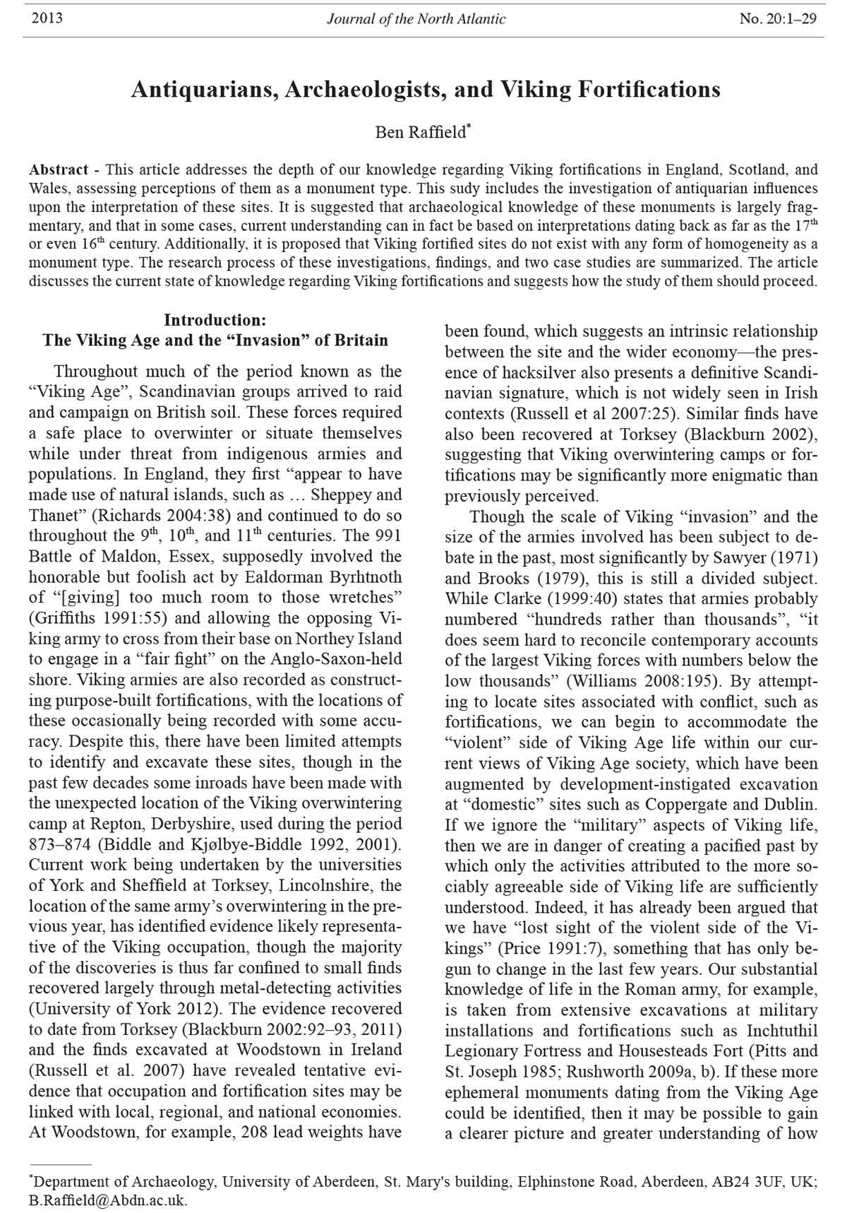
In Britain, the most extensively excavated Viking
fortification is the 873–874 overwintering camp at
Repton, Derbyshire, where a substantially defended
D-shape enclosure was located on the south banks
of an old course of the River Trent (Fig. 1). The
defenses included a fortification ditch over 8 m
wide and 4 m deep, the upcast of which would have
formed the interior defensive bank. The Anglo-Saxon
church of St. Wystan was also incorporated into
these defences, presumably as a fortified gatehouse.
The location of a number of Scandinavian burials
exhibiting signs of violent trauma and a mass grave
within a reused Anglo-Saxon mausoleum has been
taken as suggesting that this was the site inhabited
by the Viking Great Army during their overwintering
2013 B. Rafffield 3
in Repton (Biddle and Kjølbye-Biddle 1992, 2001).
Despite being the best-understood Scandinavian
fortification of the period in Britain, elements of the
site remain perplexing. It is also postulated that the
enclosure encountered may only be the center of a
larger overwintering camp (Williams 2008:198), but
this has not yet been identified.
Anglo-Saxon fortifications, in contrast, are far
better understood, with the fortified settlements, or
burhs, constructed by Alfred of Wessex and his successors
having been studied for some time; these
continue to be investigated by both archaeologists
and historians (Bassett 2007; Brooks 1964,; Haslam,
in press [a], [b]; Hill and Rumble 1996; Kitchen
1984; Lavelle 2010; among many). The efforts of the
Beyond the Burghal Hidage Project based at University
College London have more recently aimed “to
provide the first systematic study of Anglo-Saxon
military organization and its landscape context for the
period ca. 850–1066” (UCL 2005), the publication
of which is eagerly anticipated. Additionally, sitespecific
research at Goltho, Lincolnshire (Beresford
1987) has revealed a series of occupations dating
from the Middle Saxon to Norman periods, including
the construction and enclosing in substantial defenses
of a manorial site in the late 9th or early 10th century,
though the dating sequence at this site has been questioned
(Reynolds 1999:130). Additional attempts
have been made to understand Anglo-Saxon warfare
on a larger scale (Lavelle 2010).
Publications on the subject of Viking warfare in
general are much more limited in number. Griffith’s
(1995) attempt to study Viking warfare is largely
problematic, with the author failing to grasp the context
of his subject and enforcing his argument from
a modern military viewpoint, despite making sound
points at times. Similarly Siddorn (2005) attempts
to study Viking military strategies and tactics based
on his experience as a re-enactor, though he does
stress that the book is not primarily designed to be
academic (Siddorn 2005:7). Attempts to tie down the
location of Viking Age battlefields have been largely
unsuccessful, though a recent volume (Livingston
2011) focusing on the 937 Battle of Brunanburh has
postulated a likely location in the Wirral. Viking Age
warfare is therefore dominated by views related to
popular misconceptions, stereotypes, and a general
acceptance of these, though past work by the author
has sought to reassess our knowledge of the subject
and construct a framework for identifying potential
sites of Viking Age conflict (Raffield 2009). Similarly
to recent investigations into Anglo-Saxon warfare,
wider-scale reanalyses of the subject matter are
being currently undertaken by Williams (in press).
It is important to recognize the significance of
contemporary sources when attempting to study
warfare during the late Saxon period and Viking
Age. The year-by-year accounts in documents such
as The Anglo-Saxon Chronicle, the Annals of Ulster,
and continental sources such as the Annals of St.
Figure 1. The fortified Viking overwintering camp at Repton, Derbyshire. Adapted from Hall (2007:85).
4 Journal of the North Atlantic No. 20
Bertin have done much to inform us of the events
of the period, though the inevitable bias entwined
within the passages must be acknowledged, as it
was likely those writing these chronicles who were
largely subject to initial Scandinavian attacks.
To understand the fortifications constructed and
used by various Viking armies or warbands is to
better understand Viking Age warfare and the Vikings
themselves. The excavations at Woodstown
and work at Torksey have shown that fortifications
and overwintering camps may be the locations of
substantial commerce and not merely a site where
an armed group chose to situate themselves for the
winter months (Russell et al. 2007) or on a more
permanent basis. The cessation of movement by an
army would mean that the group had to be supplied,
as living off the land would become increasingly
difficult with time, initiating a series of new logistical
difficulties that had to be dealt with peacefully,
through force, or a mixture of both.
Methodology
The methodology undertaken was to attempt
a survey of historic environment records (HERs),
urban environmental databases (UADs), sites
and monuments records (SMRs), and the national
monuments record (NMR) in England, Wales, and
Scotland. The search involved 82 records operating
on a city, county, and regional basis in England in
addition to four archaeological trusts in Wales and
16 SMRs in Scotland. Even from the early stages of
the study, the approach proved time consuming and
problematic—NMR records often included results
dating before and after the Viking Age and others of
dubious quality which had to be filtered out from the
more suitable material. The search of HERs was undertaken
at a relatively quicker pace; a standardized
email was sent to every HER in conjunction with
an online search of data undertaken where possible.
For Scotland and Wales, the author was redirected
to the online sources Canmore (http://canmore.
rcahms.gov.uk/) and Coflein (http://www.cbhc.gov.
uk/LO/ENG/Search+Records/Explore+Coflein/),
respectively. Finally, the journal Medieval Archaeology
was investigated for the years 1986–2007,
and the Archaeological Data Service was searched.
The latter provided a good example of the success
rate encountered throughout the search—of
130 sites containing “Early Medieval” evidence,
only one provided evidence of a fortification. This
site was a possible Anglo-Saxon fortification in
Athelney, Somerset, which has strong links to Alfred
the Great and was investigated by Gaffney and
Gater (2003).
When constructing the methodology, the merits
of a deductive approach were also considered.
This analysis would involve the use of comparative
examples from both inside and outside Britain and
the identification of arguably “Viking’” features at
such sites, combined with our knowledge of warfare
in the period to form a “model” from which to
investigate sites that corresponded to the criteria in
order to assess the probability of their belonging to
the Viking Age. Such an approach was not utilized
for a number of reasons. Firstly, the construction of
a model assumes that Viking fortification sites are
a discrete and homogenous group of monuments
that can be identified not only across geographical
space but also the centuries spanning the Viking
Age. Secondly, it also assumes that Viking armies
or warbands would construct a uniform fortification.
While Roman fortifications can be relatively easily
identified across Europe due to their overtly military
nature and construction adhering to a rigorous doctrine,
we cannot expect the same of Viking armies, as
they were susceptible to fluctuation in terms of size
(Downham 2008:342). It must also be remembered
that prior to the 11th century these groups were certainly
not “national” armies and as such would not
subscribe to any codified military doctrine. When
we therefore consider that there may be no such
thing as a “uniform” construction of fortifications,
can we really expect an applicable and recognizable
uniformity to exist over the wider European continent
which can be applied to Britain? Thirdly, this
approach would have necessitated the study of many
sites that have no known connection to the Scandinavian
presence in England.
The Antiquarian Influence on Viking Studies
Postulated fortification sites noted in the HERs
were investigated. These have previous claims of
association with the Scandinavians, either through
modern scholarship, antiquarian studies, folklore
claims, or associations with contemporary sources
and annals noted in HER records or the aforementioned
journals. This investigation was intended to
first establish what we know about these sites and
understand the influences that governed interpretation
in the antiquarian past.
There is no set date as which to ascribe “antiquarian”
writing to—indeed, in England, a rising
concern in the material evidence of the past began
in the 15th century. It is not possible to summarize
the development of antiquarianism and its entire
impact on archaeology in these few pages, but
excellent summaries are available elsewhere (see
Chippindale 1994, Piggott 1989, Schnapp 1996,
Trigger 2006, among others). A few points, however,
must be noted here. In England especially, folklore,
anthropology, and linguistic data heavily influenced
archaeological interpretation (Trigger 2006:138);
2013 B. Rafffield 5
the Vikings held a prominent place within antiquarian
studies from the 16th century, when “politics and
religion inspired an interest in the good old days of
an independent Anglo-Saxon state” (Hall 2007:218).
Any understanding of prehistory was very limited,
with scholars having “no sense of chronology
apart from what could be ascertained from written
records” (Trigger 2006:86). Prehistoric remains
were arbitrarily ascribed to the Viking presence in
England, with even Stonehenge at one point being
postulated by some to be a Danish construction
due to comparison with the “Hunnebedden” (long
tombs with massive capstones in Holland) that were
thought of as “prototype” versions of Stonehenge
(Chippindale 1983:61). Following correspondence
with Danish antiquarian Olaus Worm (1588–1655),
Dr. Walter Chaleton (1619–1707) postulated that
similar monuments in Denmark known as “dysser”
were such prototypes for Stonehenge. Given that
the Danes were known to have invaded Britain in
the 9th century, it was proposed that the idea migrated
with them (Chippindale 1983:61), resulting
in the construction of Stonehenge. The Saxons and
Romans, who were also well-documented invaders
and settlers of Britain, or the ancient Britons whom
the Romans had encountered, were also regularly
evoked when attempting to associate monuments
with certain periods (Trigger 2006:86).
This paper discusses 40 sites that HER records
show to have been postulated to have been used by
the Vikings during their time in Britain (see Fig. 2
for map, Appendix 1 for gazetteer), the associated
sources suggesting that archaeological remains related
to 25 of these had been first identified as Viking
by antiquarians. Certain regions of Britain were
much more heavily represented than others, with the
east of England especially yielding a large number
of sites (17 from Bedfordshire and Essex alone).
Scotland yielded only a single site from the Outer
Hebrides, while two sites were located in Wales: one
of which is associated with the 893 battle at Buttington,
Powys, and another with a fortified settlement
at Llanbedrgoch, Anglesey, which may have been
under Viking occupation (Redknap 2008:406).
As Appendix 1 will show, however, not all sites
that have been identified as Viking fortifications
by antiquarians have been followed up by modern
scholarship, the limitations and speculative nature
of the available sources being recognized. In other
cases, antiquarian writers may indeed have observed
features that represented the extant remains of Viking
camps or fortifications, but these have since
been destroyed with no traces surviving in the
modern day (see, for example, Spurrell [1885] on
Benfleet and Boyd-Dawkins [1873] on Buttington).
Whether these features truly did represent fortifications
may never be known. Additionally, other sites
such as the “Aldewerke” in Cambridgeshire have
been identified in more recent times, and it is these
that are often stronger contenders for being of early
medieval date. In a few cases, however, possibly
spurious sites identified in the antiquarian past have
permeated the modern literature.
While investigating the antiquarian influence on
Viking studies and the sites in this paper, a chain of
inter-relying interpretations was encountered with
regards to an earthwork at Barton-Upon-Humber,
Lincolnshire. This site was thought to possibly
represent a Viking fortification or “burh” (Bryant
1994:73, Heritage Gateway 2006, Reynolds
2003:117), though Rodwell and Atkins (2011) postulate
that it could date to the middle Saxon period.
With little dating evidence available, the attribution
of this site to the Vikings was based on place-name
analysis, stratigraphic relationships, and comparison,
with Bryant (1994:75) citing two comparative
examples—Howbury (also known as Renhold) in
Bedfordshire and Ringmere in Norfolk. Bryant
references the work of Dyer (1972), who notes both
of these sites as being of Viking provenance in an
article regarding the “earthworks of the Danelaw
frontier”, which looked to identify Viking fortifications
mainly in the Bedfordshire landscape. Richards
(2004:39–40) also cites these two sites, among
others, suggesting that Dyer’s work has certainly
had some influence on our interpretations of fortifications
today. Given the context within which Dyer
was working, however, his attempt to associate
previously undated earthworks with the historically
well-documented Viking presence in the Bedfordshire
region would always be a difficult task—there
are simply too few sources of reliable information
on the subject and too few sites that have been
subject to excavation. As such, he references and
seems to have been heavily influenced by the 1904
Victoria County History for Bedfordshire (Goddard
1904), which features many of the sites mentioned
in his article. Goddard, in turn, seems to have obtained
information from older sources, personal
correspondence, and at least in part from the works
of John Leland (1503–1552). Writing on Renhold,
for example, he notes that Leland stated that a
number of skeletons were found between here and
Bedford, which may have been Vikings operating
out of the “Danish outposts” of Renhold and Willington
(Goddard 1904:285). It is significant that
as early as 1900, however, Armitage (1900:260)
had recognized the dangers of relying simply on the
interpretations of those past, stating that “it seems
strange that in the nineteenth century any archaeologist
of reputation should still follow the method
of the archaeologists of a hundred or two hundred
years ago, who first guessed at things, and then said
they were so.”
6 Journal of the North Atlantic No. 20
Figure 2. Distribution of postulated Viking fortification sites identified through search of HERs.
2013 B. Rafffield 7
This example shows that through a reliance on
older sources and a lack of targeted investigation it
is possible that in some cases archaeologists have
been inadvertently using 16th-century antiquarian
interpretations as a basis for hypotheses, due to a
reliance on these when county histories were being
compiled in the early 20th century. When laying out
the sites utilized in the study in a gazetteer (see Appendix
1), the antiquarian influence in some areas of
the country was clear to see.
Despite the heavy antiquarian influence in
certain areas of the country, these interpretations
should not be seen as an obstacle to be overcome by
archaeologists but instead as a useful tool, though
they must be considered with care. It is also likely
that further antiquarian sources were used but not
officially referenced in the older texts, making the
identification of sources difficult. Given the chain of
interpretations in Bedfordshire stretching back from
Dyer (1972) to Leland, that Dyer’s “fortifications”
continue to be referenced can only be problematic.
Dyer’s bibliography also includes other early 20thcentury
works such as Allcroft’s (1908) Earthwork
of England and further illuminates his reliance on
outdated sources, which has seriously impacted our
interpretation of these sites in light of the absolute
lack of excavation work that has occurred at many
of them. Indeed, where excavation has taken place,
sites such as Willington Docks (Fig. 3) have been
reinterpreted as later medieval sites (Edmondson
and Mudd 2004, Hassall 1975).
The use of antiquarian sources should not, however,
automatically lead to the dismissal of theories
based upon such work. Such studies were largely
based on field observations, folklore legends, and
tales related to them by locals of an area and which
often included a Viking Age influence. “Battle
Hills”, Essex, for example, is believed to be a Danish
burial ground due to the red-berried Danewort
plants which grew there. Camden recorded in his
(1607) work Britannia that the local inhabitants
“still call [it] by no other name than Danes-bloud …
[due to] the number of Danes that were there slaine,
verily beleeving that it blometh from their bloud”
(Sutton 2004). As such, antiquarian interpretations
tend towards the rationalizing—making sense of local
legends or monuments of unknown dates through
the tales that were related to them. With regards to
the relationship between archaeology and folklore,
“folklore cannot be accepted on face value as portraying
factual truths about the past. But neither
can it be rejected as false … Acknowledging the
historical dimensions of items of folklore can allow
us to develop analytical approaches to their
use as historical sources” (Gazin-Schwartz and
Holtorf 1997:14).
Figure 3. The “Danish Docks” at Willington, Bedfordshire. Excavation has shown this to be a later medieval site. Adapted
from Allcroft (1908:386).
8 Journal of the North Atlantic No. 20
The approaches of archaeology and folklore in the
past were united through the works of antiquarians
and it is only with the rise of archaeology as a modern-
day scientific discipline that we see interpretations
moving away from the use of the latter, though
it must be remembered that folklore remains important
as part of an interdisciplinary study. Indeed,
in Camden’s discussion of Bedfordshire, he makes
note that Viking fortifications were constructed at
“Temesford” (Tempsford), Benfleet and Shoeburyness
in 917 and 893, respectively (Sutton 2004).
This reference demonstrates that Camden possessed
a knowledge of The Anglo-Saxon Chronicle and as
such historical enquiry was entwined with that of
the anthropological. This example also suggests that
scholars may have possessed some kind of pre-disposed
idea of what they were specifically looking for.
A better understanding of these sites can only be
obtained through focused research and investigation.
For example, Risinghoe, Bedfordshire, theorized by
Goddard (1904:296) to be a Viking observation
platform or burial mound, has since been reinterpreted
by English Heritage as a motte and bailey
castle. Since we cannot be sure as to what form Viking
fortifications took (with only one having been
confidently identified in England), more intrusive
investigation is likely necessary to try and establish
the true nature of these sites. Though many years of
experience go into reinterpretations based on field
visits, the construction of a research framework
within which to investigate a selection of sites may
do much for our knowledge
of early medieval
earthworks.
Despite the lack of
study that had taken place,
it seems that there are
prevailing characteristics
of a Viking site that seem
to have emerged as being
apparent to antiquarian
investigators. These
are attested to by Spurrell
(1890) and Goddard
(1904). Spurrell (1890:79)
states that the earthworks
forming part of a large enclosure
at Shoeburyness,
Essex, are “in accordance
with the general mode
of fortification [used] at
that time both by Danes
and Saxons” but does not
elaborate on this. Armitage
(1900:262) notes,
however, that she is “not
aware that any serious attempt
has ever yet been made to ascertain what the
nature of an Anglo-Saxon fortification was”, despite
the fact that Spurrell evidently possessed some ideas
regarding this. Shoeburyness is the location of a fortification
constructed in 893 following the destruction
of Hastein’s fortification at Benfleet. Though the
substantially sized enclosure identified as the site by
Spurrell has since been reinterpreted and is listed as
a slight univallate hillfort (English Heritage 2011),
it is possible that this was re-occupied by the Viking
force. Unfortunately, much of the enclosure had
been destroyed by a garrison by 1890, with only two
stretches of earthwork still visible by 1903 (Fig. 4).
The enclosure has also been heavily truncated by the
sea.
Goddard (1904:280) also highlights cultural indicators
of Viking fortifications when describing the
sites at Etonbury, stating that “the small mounds at
the end of the ramparts are found in works reputedly
Danish”, while Willington Docks has “certain unusual
features, which appear to mark it also as Danish”
(Goddard 1904:282). Laver (1930) also notes
that at Pandal Wood, Essex mounds are incorporated
into the earthwork banks (Fig. 5). It does seem,
therefore, that rules of some form were constructed
by various antiquarians by which they designated
sites as “Viking”, though these are largely unknown
today. As such, the modern interpretations based
upon these may well be in serious need of a review,
given thus far that only one site (Repton) can actually
be considered to be of Viking origin and this
Figure 4. The heavily truncated remains of the postulated Viking camp at Shoeburyness,
Essex. Adapted from Chalkey Gould (1903:287). Plan courtesy of the Victoria County
History, University of London.
2013 B. Rafffield 9
ly Viking (perhaps from comparison with sites such
as Hedeby), and indeed this form has been confirmed
archaeologically at Woodstown and Repton, though
these two enclosures are of a very different scale.
Many circular sites such as Renhold, Bedfordshire
have been re-designated as “ringworks” by English
Heritage, and Dyer (1972:231) admits that these are
problematic: “there is a greater chance of confusing
these sites with Norman ring-works, and indeed only
excavation is likely to establish their identity with
certainty”.
Of the 40 sites in the gazetteer (Appendix 1),
nine have finds associated with them which have
been used to support theories of a Viking or Scandinavian
connection. Some of these were recovered
by antiquarians themselves and have contributed
to their interpretations. At Gainsborough, Lincolnshire,
for example, Allen (1834) noted the recovery
of a “battle axe” among other finds, while at Frogmore
Lodge, Hertfordshire, “swords” and “axes”
were recovered (Pollard 1906). At Buttington, Powys,
Boyd-Dawkins (1873) notes skeletons recovered
from the churchyard as displaying battle trauma,
relating these to the 893 siege and battle recorded in
The Anglo-Saxon Chronicle (Swanton 2000:87). Finally,
at Benfleet, Essex, Laver (1903:236) relates a
local tale dating from the 19th century telling of burnt
ships and human remains being found in the creek
thought to date from the 893 battle in the vicinity.
For other postulated
sites, other stray finds
are better recorded.
At Blunham, Bedfordshire,
an Anglo-
Saxon spearhead was
recovered in the vicinity
of the site close
to TL151 525 (Beds
HER 9772), while
more recently an Anglo-
Saxon strap-end
was recovered just to
the east of the site (M.
Edgeworth, University
of Leicester, UK,
2011 pers comm.).
Though the Viking
fortification of 893
at Benfleet is as yet
unlocated, a Byzantine
coin dating 850–
950 (Essex HER No.
46854) was found in
Benfleet Creek. Such
coins are thought to
have been brought to
Britain by individuals
site was only located by chance through modern
archaeological investigations.
Some supposedly “Viking” features are speculated
upon, however. Cohen (1965:42) spuriously
takes the existence of “inner and outer wards”
at Willington Docks, Bedfordshire to be similar
to those seen at Trelleborg. Goddard (1904:284)
describes sheltered “boat nausts” at the site as
typical Viking features—the “Northmen were accustomed
to provide some such shelter for their
fleets when campaigning.” Dyer (1972:229) asserts
that the presence of D-shaped enclosures at the site
bears similarities to the semi-legendary and as yet
unidentified fortress of Jomsborg, which supposedly
possessed separate fortifications for both the
garrison and for shipping, though he notes that “it
would be unwise to carry the similarity farther.”
The importance that Dyer places on “harbour”
sites is reflected by his identification of another in
Bedfordshire at Clapham on the River Great Ouse,
though this has since been lost to quarrying. As has
been mentioned above, however, excavation at Willington
has suggested later medieval occupation
(Edmondson and Mudd 2004, Hassall 1975).
It seems that the most important factor in recognizing
a “Viking” fortification was the form of the
site itself—a circular form being taken as representative
of the Trelleborg fortresses, while a D-shaped
fortification on a river is taken to be characteristical-
Figure 5. An earthwork enclosure at Pandal Wood, Southminster, Essex, postulated to be of
Viking construction. Adapted from Laver (1930:256) by kind permission of the Essex Archaeological
Society.
10 Journal of the North Atlantic No. 20
Dyer (1972:226) records it as an irregular D-shape.
From this study, it can be suggested that both Goddard
and Dyer certainly possessed pre-conceptions as
to the form that a “Viking” site should take. Goddard
(1904) does not specifically highlight a D-shape as a
Viking “signifier”, but it could be that this was seized
upon by Dyer as some sort of indicative feature. His
preconceptions may to some extent be based on the
form of Viking Age enclosures in Scandinavia such
as Hedeby, and he looked to locate sites conforming
with this; indeed, Reynolds (2003:117) states
that “the earthwork enclosures first considered by
James Dyer … share, very broadly, a D-shaped plan
form”, suggesting that Dyer was one of the first to
identify sites based on their D-shaped form. Dyer
also draws heavily upon the Trelleborg fortresses as a
comparison for the Bedfordshire earthworks, though
this argument is also less than convincing considering
their relatively late date and the vastly different
socio-political environment which was prevailing in
late 10th-century Denmark when compared to late 9thand
early 10th-century Bedfordshire. (Though it must
remembered elsewhere that the Trelleborg fortresses
pre-date the later phases of Viking activity in Britain.
That Dyer’s article is titled “The Earthworks of the
Danelaw Frontier”, however, surely places his focus
in the late 9th/ early 10th century). Though circular
earthworks with “a timber-faced earth rampart surrounded
by a wide ditch … [have] excited interest”
(Hall 2007:76) in the Low Countries, these are just
as likely to have been constructed as defensive structures
by the indigenous populations as by the Vikings
themselves. These constructions nevertheless shows
circular fortified earthworks to be possibly late Saxon
or Viking Age, though the degree to which this can be
considered to be diagnostic is questionable.
In addition to shape, there also seems to be a
concern with the area covered by the Bedfordshire
fortifications. Of the seven sites recorded originally
as part of Goddard’s (1904) Victoria County History,
five of these are relatively similar in size—the
diameter of the two circular sites he mentions differing
only by 20 m. Three of the D-shaped earthworks
are similar in size, with the site at Etonbury being
the only one that is significantly larger, though the
truncated nature of this site makes estimating its size
difficult. The only significantly smaller site is Gannocks
Castle, Tempsford (Fig. 7), measuring only ca.
60 m (200 ft) across.
In the case of Gannocks Castle, the site was identified
as a Viking fortification in an attempt to locate
the historically recorded 917 fortification and battle
at Tempsford. The small size of the site is justified
as representing this historically important fortification,
siege, and battle through the construction of
a fictitious scenario by Goddard (1904:282). This
interpretation involves the combined Huntingdon
within Viking armies or via the long-range trading
routes that the Scandinavians are known to have
operated . Other features have been located through
excavation, such as the furnished Scandinavian burials
located at Repton, Derbyshire (Biddle and Kjølbye-
Biddle 1992), while at Llanbedrgoch, Anglesey,
hacksilver was recovered in addition to possible execution
victims in the ditch enclosing the settlement
(Redknap 2000). Finally, at The Udal, North Uist,
the Scandinavian occupation is supported by pottery
finds (Lane 2007), though the true nature and shortlived
occupation of the small “fort” there is still not
fully understood, though it “soon went out of use
and was downgraded to a cabbage patch enclosure”
(Graham-Campbell and Batey 1998:173).
In terms of supporting a Viking presence, those
finds that can be argued to be reliable indicators are
few in number. The finds at The Udal, Repton, and
Llanbedrgoch have been obtained through modern
archaeological excavation, while the stray finds at
Blunham and Benfleet, while convenient, cannot be
taken as hard evidence of the hypothesized Viking
fortifications there, despite nearby fortifications being
attested in the historical sources, as they were not
found in secure archaeological contexts relating to
the sites. That such finds are being recovered, however,
could be suggestive of a possible Scandinavian
or late Saxon occupation in the vicinity. Regarding
earlier finds such as those at Gainsborough and Frogmore
Lodge, these must furthermore be considered
in the context of what investigators were specifically
looking to find—that is to associate these locations
with a postulated Viking occupation.
Case Studies: Bedfordshire and Essex
As noted above, the study identified two concentrations
of postulated “Viking” fortifications
identified by antiquarians and later scholars, one
of which unsurprisingly lies in Bedfordshire,
while the other lay in Essex. The features of these
sites were compared to investigate whether their
interpretation could lie in the identification by
antiquarians of certain “diagnostic” features that
provided the reason for their being assigned to the
Viking Age.
In Bedfordshire, eleven possible sites were located
by the study (Fig. 6), one of which has been
hypothesized recently by Edgeworth (2008) to be the
site of the 917 fortification and Battle of Tempsford.
Of the remaining ten Bedfordshire sites, eight have
been identified as having their roots in antiquarian
interpretation. Five of these involved possible
D-shaped earthworks, while four consisted of possible
circular earthworks. The site at Manor Farm,
Bolnhurst, has been significantly truncated to the
point where it could have possessed either, though
2013 B. Rafffield 11
these earthworks as Viking. Goddard states that the
army was largely destroyed at the walls of Bedford
(a battle and Viking defeat being recorded in The
Anglo-Saxon Chronicle in 917 [Swanton 2000:101]).
and East Anglian army being previously encamped
at Renhold (which possesses fine views west over
the Great Ouse valley towards Bedford) and Willington,
thereby also justifying the interpretation of
Figure 6. The theorized Viking fortification sites in Bedfordshire obtained from the sear ch of HERs.
12 Journal of the North Atlantic No. 20
the north and west sides by the extent of Benfleet’s
churchyard. Spurrell (1890) identified a large enclosure
at Shoeburyness, postulating this to be the site
of the 893 fortification (though, as mentioned above,
this site is now considered to be a hillfort). Though
this site has been heavily truncated by the sea, it
would have been of substantial size, which would
perhaps be expected of a fortification designed to
house more than one Viking army. It is worth noting
that reoccupation of an extant Iron Age earthwork
by the Viking forces is a distinct possibility. A fortification
identified in Pandal Wood, Southminster by
Laver (1930) measures 116 m by 98 m, the form of
the site being roughly pentagonal (Fig. 5). This site
includes mounds built into the banks as well as within
the interior (Laver 1930:257), which is a feature
shared by Edgeworth’s hypothesized location for the
917 Tempsford fortification at Blunham as well as at
the postulated longphort at Dunrally in Ireland. Laver
attributes this site to the invasions of Knútr, though
no finds were recovered at the site. At Danbury Camp,
Chelmsford, first identified by Morant in 1786, Morris
and Buckley (1978) determined that if a Viking occupation
did exist at the 140-m by 50-m site, then this
was largely aceramic. The site has been heavily truncated
by market gardening, and as such, its plan is unclear.
The final site is “Canute’s camp” at Canewdon,
Rochford, recorded by Chalkley Gould (1903) as being
“oblong” in plan and enclosing ca. 6 acres, though
no upstanding remains of this earthwork survive. The
site is visible on old maps, however, and can be seen
attached to the Pastscape record for this site (English
Heritage 2007).
In contrast with the Bedfordshire
sites, those in
Essex seem to share a more
rectilinear-based plan,
though Rodwell and Atkins
(2011:842) postulate
that roads and trackways
at Benfleet have fossilized
a D-shaped circuit of
defences. The irregularities
are more pronounced
than those that exist in
the Bedfordshire sites. The
size of the Essex sites is
clearly more varied than
those identified by Goddard
in Bedfordshire. Two
of the Essex sites (Pandal
Wood and Canewdon)
are arbitrarily ascribed to
the 11th-century raiding
armies of Knútr (Chalkley
Gould 1903, Laver 1930),
by which time the Danes
The surviving remnants of this force are narrated as
having retreated to Tempsford to construct a very
small fortification to reflect the diminished size of
the army. This site is conveniently identified at Gannocks
Castle. In his description of Willington Docks,
Goddard (1904:282) also notes that the “harbour”
here would have been capable of housing “between
twenty-five to thirty ships of the Gokstad type, which
would allow for a force of about 2500 men”—a size
that might be expected of two combined regional
raiding armies and supporting the numbers postulated
at the beginning of this article for larger armies.
This example demonstrates the weight of historical
sources in influencing perceptions of the Viking Age
in the past; in some cases, there was a concern with
interpreting the size and form of a site in order to
associate a historically attested Viking army—that
which was destroyed at the Tempsford fortification
in 917—with otherwise unknown and un-interpreted
earthworks of the size befitting an initially large and
thereafter diminished force.
Another cluster of five sites (the fortification on
Mersea Island is as yet unlocated) was identified in
Essex (Fig. 8), which was studied to provide comparative
evidence to the Bedfordshire sites. With both
counties being on the periphery of the “Danelaw”, it
could be anticipated that the sites may share similar
characteristics if indeed they were of Viking construction.
The “fortifications” in Essex in fact vary
greatly in size and form. Earthworks supporting
Spurrell’s (1885) hypothesis for the location of the
893 Benfleet fortification are no longer extant, though
he hypothesizes that the site was in part bounded on
Figure 7. The medieval manorial site at Gannocks Castle, Tempsford, once hypothesized
to be the 917 Tempsford fortification. Image adapted from Allcroft (1908:385).
2013 B. Rafffield 13
greater irregularity of the Essex sites is the fact that
they are identified by four different antiquarians or
archaeologists, which directly contrasts with the
“Viking” sites in Bedfordshire, identified largely
through the work of Goddard (1904) and later by
had certainly been constructing fortifications to a
circular plan in Scandinavia as seen with the Trelleborg
fortifications, so the concern with these sites
was probably not due to their being of a representative
shape or form. What may be a key factor in the
Figure 8. The theorized Viking fortification sites in Essex obtained from the search of H ERs.
14 Journal of the North Atlantic No. 20
Dyer (1972). The inland nature of three of the five
Essex sites may also partially account for the greater
irregularity in form, as the majority of Bedfordshire
sites are associated with shipborne Viking forces.
Both Bedfordshire and Essex feature sites incorporating
mounds within “defences”, which has been
noted at longphort sites in Ireland, as mentioned
above. Whether this can be truly considered a “Viking”
trait, however, cannot be confirmed as of yet.
The varied nature of the postulated sites and the
lack of excavated examples means that at present
we cannot be sure as to what form a Viking Age,
Scandinavian fortification in Britain would take.
The conflicting evidence of Repton and Torksey
seems to suggest, on one hand, that a Viking fortified
site should be a heavily defended and overt symbol
of military occupation, while at the same time, the
occupation of a Viking army may in fact involve
intensive trade, manufacturing, and the occupation
of an area utilizing natural defensive features or no
fortifications at all. That these two sites were used
only a year apart indicates that there are unknown
factors at play, which work at Torksey may be able
to shed light upon. It could be significant that The
Anglo-Saxon Chronicle states that the Viking army
“took winter-quarters … [and] the Mercians made
peace with the raiding-army” while at Torksey. The
next year, at Repton, the army “took winter-quarters
there, and drove King Burhred across the sea”
(Swanton 2000:72). The presence and form of fortifications
may have been directly related to military
threat and the nature of political allegiances at any
given time, further highlighting the highly fluid nature
of the relationships between Viking armies and
indigenous populations.
The case studies in Bedfordshire and Essex show
that certain features of sites may have been targeted
as being perceived as indicative of a Viking occupation
or construction. D-shaped enclosures feature
regularly, especially in Bedfordshire, while the
use of ships for which the Vikings are so famously
known means that these sites are often associated
with rivers or other bodies of water. As is noted with
regards to Gannocks Castle and Willington, stories
can be interwoven with these sites to explain why
they take a certain form in order to correspond with
historically recorded events. At this point, therefore,
while the nature and date of these sites is so open to
debate and interpretations are liable at times to be
clouded by past speculation, constructing a prospective
“model” of what a Viking fortification may look
like from the sites included in the gazetteer (Appendix
1) is impossible.
The discussion regarding the size and form of
Viking fortified sites at present may run in a full
circle, as despite D-shaped and circular fortifications
having been archaeologically located both in
Ireland and England and on the continent, there is
nothing thus far to insinuate that these are decidedly
Viking traits; indeed “D-shaped enclosures are
found in pre-Viking contexts in England and in areas
without the Danelaw” (Reynolds 2003:119). When
all 40 sites across Britain were compared, D-shaped
sites were a minority when compared to circular
sites, and both of these occurred less frequently than
sites of an altogether “other” form. Given that confidently
identified sites in Ireland and Scandinavia
such as Woodstown and Annagassan and Hedeby
feature such enclosures, this is further evidence
that a deductive methodology would not have
been suitable for this particular study. The evident
diversity of sites perceived to be of Viking origin
should therefore suggest that archaeologists possess
an open mind about the relationships between the
physical appearance of a site and its origins (indeed,
it must be considered that a substantial static
army may not have used fortifications at all). The
Bedfordshire sites also proved to be unique when
compared to sites from other counties in that 7 of
11 sites were associated with waterways, suggesting
again an evident concern in Britain to associate
these sites with a certain idea of the way in which
Viking armies were moving through the landscape.
The raiding army which constructed the Tempsford
fortification is recorded in part as moving south from
Huntington (Swanton 2000:101); the quickest route
to do so being by river, so could past scholars have
possessed a concern with “identifying” sites specifically
to accommodate theoretical Viking shipping?
Willington Docks, for example, was perceived to
have nausts to house up to 35 ships (Goddard 1904),
while at Tempsford, Dyer (1972:225) postulates that
“the Danes are more likely to have built on the west
bank, with their boats on the river behind them”. As
such, it seems that this particular Viking army was
considered to be a shipborne force. The high number
of riverine sites, especially in Bedfordshire, is likely
reflective of this, though such sites were not confined
to the county. The site at South Cove, Suffolk
(Fig. 9) is situated adjacent to a former riverbed and
thought to have included a quay (Morley 1924:173–
174). Morley (1924:174) goes on to compare this
site to Warham Camp, Norfolk and also a Danish
camp in Bedfordshire on the River Ouse. Therefore,
while postulating that the site represents the Domesday
sea-port of Frostenden, Morley is attributing a
Viking construction to the site, the resemblance to
other “Viking” sites and the location of the site by
a waterway being the contributing factors to this interpretation.
He spuriously dates the site to 876 and
associates it with a Viking retreat following a defeat
at Bloodmoor Hill (Morley 1924:177).
Similarly, the sites at Canewdon and Pandal
Wood, Essex, are both associated with the move2013
B. Rafffield 15
ments of Knútr’s army. In 1016, Knútr is recorded
as “[turning] back up into Essex”, having been
previously driven towards Sheppey by Ealdorman
Eadric (Swanton 2000:151). It was after this that
the battle was fought at Assandun (Ashingdon,
Essex), which lies just under two and a half miles
to the west of Canewdon. Again, here we may be
observing the identification of a camp or fortification
site based on its proximity with a historically
recorded battle.
Regarding the size of fortifications, it is also
necessary to assume that, in addition to troops,
the armies would have possessed animals, supplies,
and other material associated with warfare.
It is also likely that they were accompanied by
associated camp followers. As such, the size of
suspected sites must take this into account. For the
fortification at Repton, for example, it is possible
that various parts of the Great Army were billeted
in the landscape around the overwintering camp
that is represented by the D-shaped
earthwork, or indeed that this earthwork
may be only the central feature
of a much larger, as yet unidentified
enclosure. In light of this, the large
site postulated by Edgeworth (2008)
(Fig. 10) to be the 917 Tempsford fortification
at Blunham may not be of
unreasonable dimensions if the enclosure
was to house the raiding armies
of Huntingdon and East Anglia in
addition to their combined stores and
followers.
The size of the “great army” and
Viking armies in general has been
considerably debated (Abels 2003,
Brooks 1979, McLeod 2006, Roesdahl
1998, Sawyer 1971, among others). It
is likely, however, that numbers fluctuated
greatly depending on the number
of groups partaking in a campaign,
Figure 10. Site postulated by Edgeworth to be the 917 Viking fortification of Tempsford. The site is in fact situated just
inside the adjoining parish of Blunham. The possible D-shaped enclosure within the red box (marked as “the castle” on old
maps (Edgeworth 2008:8) measures some 200 x 80 m. Photo courtesy of The Heritage and Environment Service, Bedfordshire
County Council, RAF 106G\UK\635.10\AUG 45\F20\1154\430.
Figure 9. The Domesday sea-port of Frostenden, hypothesized to originally
be a Viking fort and quay. Reproduced by kind permission of the Suffolk
Institute of Archaeology and History. No scale available.
16 Journal of the North Atlantic No. 20
their status, and the rate of attrition that was suffered,
as well as the regularity of which groups
joined the larger force. The Anglo-Saxon Chronicle,
for example, records that the “great army” divided
in 875 and 877 (Swanton 2000:74), while Downham
(2008:342) postulates that the leader Guthrum
joined the army in 871. As such, we cannot expect
fortifications to maintain uniformity in size even
through the events of a single campaign, and it is
likely that their size would fluctuate on a fairly regular
basis depending on the size of the area chosen to
be enclosed or whether any area was chosen to be
enclosed at all.
While fortifications may indeed take the form
of D-shaped enclosures (this is an obvious choice
for any group possessing ships wishing to safely
enclose themselves), at present it is not possible to
make judgements on a “Viking” site based purely
on form and size. Even where similarities in form
are shared, the vast difference in size of the Woodstown
site and the known extent of Repton suggests
that individual factors certainly come into play.
Given the evidence suggesting substantial trade
and manufacturing at Woodstown, as well as the
large number of ship rivets (Russell et al. 2007:15),
it seems that a long river frontage may have been
a core requirement of the site. The tiny “fort” encountered
at The Udal, depending on the circumstances
of the Viking settlement in the Western
Isles, may never have held a real functional use, especially
considering its short life-span, and would
certainly be able to accommodate only a small
number of people. Could it be here that there was
an initial need for small-scale, localized defence,
or indeed a display of dominance in the immediate
landscape? There is also the possibility that promontory
sites were being fortified. At Burton Point,
Cheshire, a promontory site is arbitrarily associated
with the Viking leader Ingimund (English Heritage
2012b), though such sites are associated with the
Viking Age in the Isle of Man (Cubbon 1983, Gelling
1952, Wilson 2008). “Most promontory forts
on the island … [are small,] cutting off a headland
overlooking the sea by means of a bank and external
ditch” (Wilson 2008:18). These sites, however,
demonstrate multi-period occupation, and though
they certainly seem to have been utilized or reoccupied
during the Viking Age, it is unlikely that these
had associations with large armed groups such as
we would consider an “army”, though it may be
that they are related to local elites.
Finally, as has been alluded to, it must be noted
that fourteen of the sites featured in this study no
longer possess extant earthworks that were noted by
antiquarian scholars, or the postulated Viking sites
have not been associated with any visible archaeological
features.
With too many variables that could affect the
composition of Viking forces, there is probably no
diagnostic shape for such a site, which markedly
differs from the comparatively easy identification of
military fortifications, such as those of the Roman
period, for example. What is clear, however, is that
there is a significant degree of monumental diversity
even in those few sites that have been confidently
identified, while other postulated sites take a number
of forms.
Finally, the extent to how many of these sites (if
any) can be considered to really represent Viking
fortifications must be considered. Obviously, those
revealed through modern archaeological excavation
present the most promise, though in the case of The
Udal, the relationship between the “fort” and the
Scandinavian settlement of the area remains unclear.
At Llanbedrgoch, the presence of hacksilver indicates
the influence of a silver bullion economy—a
strong Scandinavian trait—though it must be considered
to what extent the site was used (if at all)
by Viking groups; indeed it may have been Viking
raiding that led to the eventual abandonment of the
site (Redknap 2008:406).
The demographics of these sites may also vary;
it has been postulated that women found buried in
the mass grave at Repton may have been English
given that the site was a double house monastery
(Biddle and Kjølbye-Biddle 1992, Richards 2003).
These monasteries were often established under
royal patronage and served the important function
of maintaining the cult of the royal family and its
members (Foot 2000:336). Isotope analysis on one
of the female skulls at Repton, however, suggests
that she may have originated from Scandinavia or
continental Europe (Budd et al. 2004:138), throwing
into question the notion that all 18% of women
who made up the mass grave at Repton were English
(McLeod 2011:346). Processes such as textile production,
which has been revealed at Woodstown, are
thought by Russell et al. (2007:37) to be “associated
with women rather than men” in the Viking Age and
therefore further suggests the presence of women in
fortifications, though whether gender roles can realistically
be so rigorously applied is open to debate.
Some sites, such as the “Aldewerke” in Great
Shelford, Cambridgeshire, demonstrate potential,
but a lack of datable finds prevents conclusive interpretation
at this particular site. This site is taken,
however, as being consistent with “the aceramic
nature of many Saxon and Danish sites” (Malim
2000:12). Other sites, such as Danbury, Essex,
have been so heavily truncated by processes such
as market gardening that ever being able to assess
their potential may be difficult. Other, unexcavated
sites are altogether harder to interpret. The Blunham
site possesses some good circumstantial evidence
2013 B. Rafffield 17
(see Edgeworth 2008, Edgeworth and Fradley 2009)
but requires excavation of potential archaeological
features, such as a curvilinear feature that is possibly
a large enclosure or fortification ditch (Fig. 11),
if we are to understand it. The northwest corner of
the Benfleet fortification may be identified by the
grounds of Benfleet church, though the majority of
the fortification may likely lie under modern housing
and a substantial car park. Other sites have been
re-interpreted since being designated as “Viking”;
Beeston Berrys, Bedfordshire, for example now
being considered to be a deserted medieval village.
Other hypothesized “Viking” sites based on the association
of a site with stray finds such as Frogmore
Lodge, Hertfordshire or Gainsborough, Lincolnshire
should certainly be considered at this time for what
they likely are—undated earthworks, perhaps related
to find boundaries or agricultural activity, or
sites spuriously associated with the Scandinavian
presence in England through the location of “supporting”
artifacts. Others recorded within a general
locality or region, such as that recorded in the Stovin
Manuscript in the East Riding of Yorkshire, are unlikely
ever to be located at all if they even existed.
Placing these sites in an international context
may assist in establishing possible “norms” for
Viking Age fortification sites from which more thorough
and constructive arguments for postulated fortification
sites can be formed. Being a people with a
wide geographical reach, the Vikings can only fully
be understood when their actions in Britain are compared
with their actions in the wider Viking world.
The Study of Fortification Sites in Ir eland and
Scandinavia
It is necessary to consider Viking Age fortifications
that have been subject to investigation outside
of Britain. Though they date from various points
spanning the entirety of the Viking Age in Britain
and existed within individual socio-economic contexts,
they still form a body of better understood
comparative evidence which can influence how we
view the British sites discussed above.
As has been mentioned, a number of longphuirt
have been located in Ireland (for these and
Scandinavian fortification sites discussed, see Fig.
12), of which Dunrally, Athlunkard, and Woodstown
consist of D- or B-shaped earthworks, while that
at Annagassan is formed by an enclosed peninsula
(Linn Duachaill 2012). All are situated by waterways.
The mixed nature of the finds at Woodstown
Figure 11. The site of the “Castle” at Blunham, Bedfordshire. In the middle distance a curvilinear feature (marked by red
arrow), possibly representing a large ditch, can be seen. Photograph by the author .
18 Journal of the North Atlantic No. 20
2013 B. Rafffield 19
suggests combined “military”, “domestic”, and
“productive” activities—the latter represented
by textile production and silver working—which
throws the nature of this site into uncertainty.
Evidence suggests that despite Woodstown being
enclosed in defences, which may have incorporated
palisades (Russell et al. 2007:32), the wide entrance
to the site (approximately 7.5 m) would have been an
impractically large gap to defend in any fortification.
Truncation by 19th-century railway works has obliterated
any trace of riverside fortifications, though
possible riverside earthworks have been noted at
Edgeworth’s site at Blunham on the River Great
Ouse (Edgeworth and Fradley 2009). The defensive
capacity of Woodstown is also thrown into question
due to the relative slightness of the ditches, which
measure 1.2 m deep and 3–4 m wide (Russell et al.
2007:32) in comparison to Repton’s 4.2 m deep and
8.5 m wide ditches. Considering those at Dunrally,
however, which measure 1.8 m deep and 5.3 m wide
(Kelly and Maas 1995:31), the Woodstown ditches
may not be significantly smaller in terms of the size
of fortifications in Ireland. The activities at the site
certainly conform with those postulated to be taking
place at Torksey, Lincolnshire, which shows that
the juxtaposition between military and productive
sites is not limited to Irish sites. The possible double
enclosure or B-shape plan of Woodstown may suggest
that the site was divided between military and
non-military activities, with “domestic” finds being
recovered more frequently from the north end of the
site, though the partially excavated nature of the site
may be responsible for this perceived distribution.
With work now being undertaken at Annagassan,
County Louth, it may be possible to begin formulating
arguments as to what processes were taking
place at the Irish sites during the Viking Age.
Known fortifications in Scandinavia are surprisingly
few in number given the frequent conflict that
took place to bring about the formation of the Scandinavian
states. The majority of fortifications occur
relatively late in terms of the Viking Age in Britain.
Alongside the Trelleborg-type fortresses, the settlements
of Birka, Sweden and Hedeby, Jutland (now
in northern Germany) are notable for the presence
of fortifications, the latter being part of an extensive
defensive system involving the use of the linear
Danevirke and Kovirke earthworks. While a general
lack of fortified sites in Scandinavia has been
noted by Hedenstierna-Jonson et al. (in press:1), the
authors stress that this should not “falsely be interpreted
as signs of a less violent time”.
The island town of Birka, Sweden was an important
center of trade and commerce during the Viking
Age. The town is dominated by a hillfort defended
by ramparts, which was in use from the mid-8th
and mid-9th centuries until the late 10th or early 11th
century (Hedenstierna-Jonson 2006:49). This site
was therefore used throughout much of the time that
the Scandinavians were operating in Britain; thus,
it is possible that hillfort sites in Britain could have
potential for Viking Age occupation if Scandinavian
groups continued to make use of this tradition. It
should be noted here, however, that the Birka fortification
was specifically a defensive site intrinsically
associated with the town itself and demonstrates exceptional
use of this fortification type during the Viking
Age (Hedenstierna-Jonson 2006:49), with the
use of hillfort sites having decreased dramatically
in the 6th century. The site therefore differs in nature
and function from the fortifications and camps in
Britain that this study is concerned with.
The Trelleborg-style fortresses surpass any hypothesized
Viking fortification sites in Britain both
in terms of complexity of construction and uniformity.
Comparative examples should again not necessarily
be looked for in Britain given the specific
socio-political, military, and economic situation
within which the Trelleborg fortresses were built
during the late 10th century. Indeed, they must also
be considered for their function as centers of royal
power alongside that of a military establishment.
As Dyer (1972) shows, however, linking hypothesized
sites with these fortifications does occur.
These sites make varying use of stone construction,
though defensive banks are consistently constructed
of earth and turf (Roesdahl 1986:215) and use an
“extraordinary amount of timber … [the rampart]
was not only covered by a plank palisade on both
sides, but also traversed in its interior, both longwise
and clockwise” (Nørlund 1948:273). The fortifications
of Fyrkat and Aggersborg, seem strategically
placed to monitor transport routeways. Aggersborg,
for example, is thought to be situated to monitor the
Limfjord, a quick and safe route allowing shipping
to traverse the Jutland peninsular and move from
the North Sea to the Baltic (Roesdahl 1986:225),
respectively. Rosedahl (1986:218) suggests that the
striking resemblance of the Trelleborg fortresses
to the geometrical fortress at Souburg in the Netherlands
may have been inspired by other sites on
the continent. Indeed, there is a growing number of
possible Viking Age fortifications on the European
continent, with those in the Low Countries postulated
as refuges constructed against Viking attack,
though these date from the last quarter of the 9th century
(Van Heeringen 1996:261). Similarly to Britain,
the population structure of these fortifications is also
Figure 12 (opposite page). Maps displaying Irish and Scandinavian sites discussed in this paper, including additional
“Trelleborg”-type fortresses.
20 Journal of the North Atlantic No. 20
thrown open to question by the excavation of women
and children in cemeteries at Fyrkat and Trelleborg,
though whether they lived within the fortification
itself or as part of the wider population outside of the
fortresses is unknown.
The settlement of Hedeby was enclosed in defenses
during the early stages of the 10th century,
with the settlement having existed as undefended for
some time (Hilberg 2008:106). Substantial evidence
for trade and the multicultural population structure
seen in reference to the burials there suggests that
this site certainly was not primarily of military use,
though an attempt was made to bring Hedeby into
the wider defensive landscape by the construction of
the Kovirke in the 10th century. Evidence for gateways
in this structure suggest that the monitoring
of traffic into and out of the area was of importance
(Dobat 2008:42). It is again necessary to highlight
here that comparative equivalents for Hedeby should
not be sought in Britain in the terms of this study—
Hedeby was a significant settlement and trading
center that warranted royal protection and as such
directly contrasts with the fortifications that this
study aims to address.
It is clear, therefore, that the fortifications
encountered outside of Britain are of a different
character than those that we would expect to find.
The Irish longphort sites provide the closest comparison,
though whether at this stage they can be
truly considered comparable in terms of form and
function is subject to opinion. The evidence from
Torksey tentatively suggests so, with further investigation
both here and at other sites being likely to
shed light on this. What can be seen, however, is
that once again there exists a considerable amount
of monumental diversity within Scandinavia,
though regional similarity does exist. As with the
Trelleborg fortresses, however, this similarity is
due to the royal building programs that initiated
their construction and should not be mistakenly
taken as a model which we might expect to locate
in Britain. Unlike the kind of sites that we might
expect in Britain, the Scandinavian fortifications
discussed above all involved the investment of significant
time, income, and the centralized control of
resources—something that is unlikely to have been
available to Viking raiding armies while in Britain.
Furthermore, these fortifications did not exist in
isolation; the example of Hedeby demonstrates that
large-scale systems of defense did exist in Viking
Age Scandinavia. While it is nonetheless important
to consider parallels between the two regions, the
differing political, military, and socio-economic
contexts attached to the fortifications within them
must also be remembered before attempting to pos -
tulate associations. At the same time, however, the
British sites should not be considered in isolation.
Hedenstierna-Jonson et al. (in press) argue that
mental boundaries would have been of equal importance
to physical ones, though these began to be
physically visualized in the landscape through the
construction of defensive systems. The importance
of topographical boundaries in Scandinavia may
be reflected in Viking Age England—the “Treaty of
Wedmore”, agreed between Alfred of Wessex and
the Viking leader Guthrum in ca. 878 made extensive
use of the rivers Thames, Lea, and Great Ouse
to divide the south and east of England between
Wessex and the Vikings who were to settle in East
Anglia. In both the 9th- and 11th- century phases of
Viking incursions, the mobile nature of the Viking
forces also meant that linear boundaries were largely
rendered obsolete. The topography of Denmark
when compared to the rest of Scandinavia may explain
the greater number of fortifications and linear
earthworks there. The Danish landscape itself was
perhaps less of a defense, as large, sparsely populated
areas of land that exist in other parts of Scandinavia
effectively allowed threats to be absorbed
by the landscape and countered before reaching important
population centers. The substantial fortifications
at Birka were most probably needed due to the
relatively easy access by which the settlement could
be approached by water and its enviable placement
at a junction of trade routes. It doses seem likely,
however, that Birka was a the center of an extensive
defense-in-depth system that existed in the Lake
Mälar region (Hedenstierna-Jonson et al., in press).
The presence of possible interior mounds at
postulated British and Irish sites could represent
the location of central structures of importance.
Hedenstierna-Jonson et al. (in press:11–12) state
that in Viking Age Scandinavia it was not was the
castle or fort, but the hall that held great importance.
These replaced the hillforts of the Migration Period,
and not until “sometime well into the Middle Ages
[were] the great halls … replaced by citadels and
castles combining the representative and symbolic
functions of the halls, and hilltop sites before them,
with more advanced military capacities.” The incorporation
of a hall into any site, however, would
certainly suggest at least a semi-permanence on the
part of the garrison and the fortification itself.
In light of the evidence from Scandinavia, we
are therefore presented with a series of paradoxes
or juxtapositions in terms of Viking fortifications
in Britain. While there has evidently been a concern
with identifying fortifications in Britain in the
past based on Scandinavian sites, these interpretations
cannot always be justified. The mobile nature
of Viking forces mean that on a day-to-day basis
camps would probably have been undefended, with
only the semi-permanent overwintering camps being
enclosed in defensive earthworks, though it
2013 B. Rafffield 21
is possible that even these were only foci of the
Viking forces settled in the wider landscape. If and
when fortifications were constructed, we cannot be
sure as to what form they took—while shipborne
forces may well have utilized D-shaped enclosures
to protect their vessels, this is not a purely Viking
trait. The mixed and fluctuating numbers in Viking
“armies” and the fact that individual leaders would
have their own methods of waging war means that
we cannot necessarily expect any uniformity in
the form, size, or even presence of fortifications.
Evidence from Britain, Ireland, and the continent
suggests that the Vikings often utilized natural
defenses such as waterways, rock outcrops, or islands,
the former recorded as being used in 870 at
Reading when the “great army” established a camp
thought to be between the rivers Thames and Kennet
(Youngs et al. 1987), while hillforts are popular
sites of refuge and defense in Scandinavia. The
familiarity with this type of defensive structure
could suggest that extant Iron-Age hillforts, or
other prehistoric, Roman, or Anglo-Saxon enclosures
or fortifications in Britain were re-occupied
by Viking armies both for overwintering (for example
York in 866–867, Nottingham in 867–868,
and Exeter in 876 [Swanton 2000:68,74]) as well
as in the longer term (see the recorded occupations
of Colchester prior to 917 [Swanton 2000:102]
and Lincoln and Leicester among others until various
points in the 10th century). The use of islands,
such as those at Mersey and Northey Islands, Essex
is attested in the contemporary sources. These
locations could provide a fixed geographical limit
within which to undertake the study of Viking activities
if occupation sites can be located.
Conclusions and Suggestions for Future
Investigations
This study has demonstrated there is, in some
cases, a significant antiquarian influence on our
interpretations of Viking Age monuments in parts
of Britain. The inevitable result of this influence is
that these monuments remain very much understudied
and enigmatic. Though inroads are now being
made into the study of overwintering camps, our
knowledge must be dramatically expanded if we
are to understand the fortifications of the Viking
armies that were operating in Britain, which could
also significantly impact our knowledge of how they
were (or were not) assimilated into Anglo-Saxon society
following the establishment of the “Danelaw”.
Examples from Europe and Scandinavia show that
potential Viking fortified sites can vary greatly in
their location, form, and size, and also in the activities
which were taking place within them, something
which is also supported by the British sites. While
D-shaped fortifications on riverbanks may well be
representative of shipborne Viking armies, it is unlikely
that sites in a dry-land context would conform
to a rigid layout in terms of their defensive plan.
With the use of natural defenses minimizing the
need for earthworks, the archaeological signature
of such sites may not be substantial, and camps of a
more transitory nature may not have utilized earthworks
at all, instead relying on sentries to watch for
an impending attack. As such, the archaeological
signature of these camps may be limited to an artifact
scatter and evidence of activities such as metal
working or commerce, as seems thus far to be the
case at Torksey. The contrast between the Irish longphort
at Woodstown and the Viking camp at Repton
shows that while these sites may be similar in form,
the size of defenses may vary depending on the imminence
of a military threat or the wish to pursue
goals such as the symbolic military dominance of
an important site of regional power, though practical
issues such as the depth of the water table may
also have an impact. Even where defenses have been
constructed, these may have been obliterated aboveground
over the last millennium, and for this reason,
some sites will only be identified through intrusive
archaeological investigation. That these sites were
primarily defensive in their purpose does not mean
that significant insights into daily Viking “domestic”
life would not be encountered. With overwintering
sites being utilized perhaps for a number of months,
it is likely that evidence of activities wholly unconcerned
with warfare would be observed. In addition
to this, it should not be assumed that Viking armies
did not attract the same camp followers that are
associated with armies throughout known history,
with Repton producing likely evidence of Scandinavian
or European females accompanying the “great
army” (McLeod 2011). Understanding how these
groups interacted in the social and domestic spheres
while acting as participants within a general context
of conflict could provide the basis for the knowledge
of a previously unknown facet of Viking Age life.
We should expect some sites to exhibit signs of
destruction, as has been noted at the fortification at
Camp de Péran, Brittany, where a circular fortification
seems to have been either occupied or attacked
by Vikings, with the collapsed rampart sealing a coin
minted at York in 902–925 (Price 1991:4). Fortifications
that were subject to siege such as Benfleet or
Tempsford would likely demonstrate similar activity.
It is likely, as excavations at Repton, Woodstown,
Fyrkat, and Trelleborg show, that burials will be
present at fortification sites, though whether these
truly represent the populations of these sites is open
to debate.
While at present no diagnostic indicators for
a Viking origin to sites may confidently be relied
22 Journal of the North Atlantic No. 20
upon, it is only through the re-evaluation and detailed
study of these sites that we can begin to understand
them. Indeed, the Vikings have proved to
be “as elusive to us today as they were to their contemporaries”
(Clarke 1999:36). Finds from the few
excavated sites that have received archaeological
attention testify to hitherto unconsidered processes
taking place within fortifications which shows that
these monuments have the potential to transform
our views of the Viking Age. The evidence for nonmilitary
activities such as manufacturing, trade, and
exchange within a silver bullion economy ironically
provides a Scandinavian archaeological signature
from which it may be possible to identify fortification
and campaign base sites used by Viking armies
or warbands. Archaeologists should endeavor to
study potential Viking sites within their landscape
contexts, as local means of communication such as
rivers and roads as well as the presence of local and
regional power centers may have been instrumental
in the placement of fortifications. By being able to
place the Vikings in space as well as time, there is
the potential to better understand the military, religious,
and socio-political impacts of the Viking Age.
It is clear that we must move towards an in-depth
and individual approach to these sites and Viking
Age warfare in general if we are to better understand
this archaeologically important period. Establishing
exactly which direction this research should take,
however, is difficult. The merits of a deductive
approach were considered at the beginning of this
paper and determined unsuitable, as this would not
take into account local, regional, or national cultural
variations and influences. It is for this reason that
resources such as the National Mapping Program
were not used—there is little use in picking out
potential “Viking” sites when we are not sure what
exactly to look for. At present, the best approach
may be to prioritize and address those sites previously
identified or supported through modern scholarship,
such as the “Aldewerke” in Cambridgeshire,
Edgeworth’s site at Blunham, and the site currently
under investigation at Torksey. Through comparison
with sites that have previously been excavated (such
as Willington Docks and Repton), it might be possible
to begin to form ideas of what we might and
might not expect to find, allowing afterwards for a
deductive approach to fortification sites. If research
at Torksey shows that fortifications were not present
there, the entire notion of such sites could be thrown
into question—is it possible that a substantial army
like that camping at Torksey would not even require
fortifications to defend itself, especially when it is
recorded in contemporary sources as having made
peace with the Mercians (Swanton 2000:72)? Could
Repton with its substantially defended compound
actually be relatively anomalous, its presence being
explained through the occupation and domination
of a Mercian royal institution by the Viking “great
army” thereby legitimizing their claim to Mercia and
forcing the exile of King Burhred to the continent? It
must also be considered that, while the fortification
may be an inner enclosure which existed as part of
a much larger enclosure (similar to “citadels” noted
at sites such as Dunrally, Ireland), it may also be
possible that no fortification was conceived to house
the entire “great army” at all, with various groups
dispersing throughout the immediate area; the Annals
of St. Bertin recorded such a practice on the
continent (Lund 1985:112). It may be that Repton
was constructed for unique political and military
means and should not be taken as an example to look
for elsewhere. The use of metal detectors has been
proved at Torksey, where hundreds of objects have
been recovered, though the preponderance of nonferrous
objects clearly shows a need for more intensive
survey to locate ferrous material. If we can truly
expect trade and commerce to be taking place at such
sites, then organized metal-detecting surveys could
perhaps be instrumental in locating them. For other
fortifications such as Tempsford, however, the fact
that this was a “campaign fortification” constructed
for the armies of East Anglia and Huntingdon to
strike at Bedford may suggest that these processes
may not be so evident. The site at Blunham itself
would substantially benefit from excavation of features
at the site to assist in proving or disproving the
postulated association with the 917 fortification. It is
fitting to end this paper with a statement from Goddard
(1904:308), who, writing at the turn of the 20th
century, states that, “the spade is … the agent most
in request to let in fresh light on the subject.” Little
has changed since; modern, intrusive archaeological
investigation is the primary means through which we
will continue to illuminate the nature and function of
these sites and better understand Viking fortification
sites. Only through data gained from excavations
will it be possible to construct a model that can be
applied to other suspected sites. Once this model is
established, it may become truly possible to begin
to understand the sites constructed and occupied by
Viking armies and therefore better understand their
important place in British history.
Acknowledgments
Thanks go to Neil Price, John Carman, Amanda
Wynne, and Laura Whitehouse for reading and commenting
on drafts of this paper, with thanks also going to Charlotte
Hedenstierna-Jonson, Lena Holmquist, and Michael
Olausson for allowing me to utilize their paper on Viking
fortifications in Scandinavia. Thanks also to John Carman
and Chris Callow at the University of Birmingham for
supervising the research from which this work derives.
2013 B. Rafffield 23
Literature Cited
Abels, R. 1997. English logistics and military administration
871–1066: The impact of the Viking wars. Pp.
257–265, In A. Nørgård Jørgensen and B. Clausen
(Eds.). Military Aspects of Scandinavian Society in
a European Perspective, AD 1–1300, (Publications
from the National Museum, Studies in Archaeology
and History, vol. 2). National Museum, Copenhagen,
Denmark. 265 pp.
Abels, R. 2003. Alfred the Great, the Micel Hoeðen Here
and the Viking Threat. Pp.265–279, In T. Reuter (Ed.).
Alfred the Great: Papers from the Eleventh Centenary
Conferences. Ashgate, Aldershot, UK. 416 pp.
Allcroft, A.H. 1908. Earthwork of England. MacMillan
and Co., London, UK. 711 pp.
Allen, T. 1834. The History of the County of Lincoln. John
Saunders, Lincoln, UK. 360 pp.
Armitage, E.S. 1900. Anglo-Saxon Burhs and Early Norman
Castles. Proceedings of the Society of Antiquaries
of Scotland 34:260–288.
Bassett, S. 2007. Divide and rule? The military infrastructure
of eighth- and ninth-century Mercia. Early
Medieval Europe 15(1):53–85.
Beresford, G. 1987. Goltho: The development of an early
medieval manor c. 850–1150. Historic Buildings and
Monuments Commission for England, London, UK.
218 pp.
Biddle, M., and B. Kjølbye-Biddle. 1992. Repton and the
Vikings. Antiquity 66:36–51
Biddle, M., and B. Kjølbye-Biddle. 2001. Repton and
the “Great Heathen Army”, 873–874. Pp. 45–96, In J.
Grahm- Campbell, R. Hall, J. Jesch, and D.N. Parsons
(Edss). Vikings and the Danelaw: Select Papers from
the Proceedings of the Thirteenth Viking Congress.
Oxbow, Oxford, UK. 368 pp.
Blackburn, M. 2002. Finds from the Anglo-Scandinavian
site of Torksey, Lincolnshire. Pp. 89–101, In B. Paszkiewicz
(Ed.). Moneta Mediævalis: Studia numizmatyczne
I historyczne ofiarowane Profesorowi Stanislawowi
Suchodolskiemu w 65. rocznicę urodzin,
Wydawn DiG, Warsaw, Poland. 571 pp.
Blackburn, M. 2011.Viking Coinage in the British Isles.
Spink, London, UK. 416 pp.
Boyd Dawkins, W. 1873. On some human bones found at
Buttington, Montgomeryshire. The Montgomeryshire
Collections 6:141–145.
Brooks, N. 1964. Unidentified forts of the Burghal Hidage.
Medieval Archaeology 8:74–90.
Brooks, N. 1979. England in the ninth century: The crucible
of defeat. Transactions of the Royal Historical
Society 1979:1–20.
Bryant, G. 1994. The Early History of Barton Upon Humber.
Barton WEA, Barton, UK. 168 pp.
Budd, P., A. Millard, C. Chenery, S. Lucy, and C. Roberts.
2004. Investigating population movement by stable
isotope analysis: A report from Britain. Antiquity
78:127–141.
Cade, J. 1785. Conjectures concerning come undescribed
Roman Roads, and other Antiquities in the County of
Durham. In a Letter to the Rev. Dr. Kaye (noe Dean of
Lincoln) from John Cade, Esq. of Durham. Archaeologia
7:74–81.
Chalkley Gould, I. 1903. Ancient Earthworks. Pp.
275–313, In H.A. Doubleday and W. Page (Eds.). The
Victoria History of the Counties of England: A History
of Essex, Vol. 1. Archibald Constable, London,
UK. 598 pp.
Chalkley Gould, I. 1908. Ancient earthworks. Pp. 389–
445, In W. Page (Ed.). The Victoria History of the
County of Kent, Vol. I. Archibald Constable, London,
UK. 622 pp.
Chippindale, C. 1983. Stonehenge Complete. Thames and
Hudson, London, UK. 296 pp.
Chippindale, C. 1994. Stonehenge Complete (Rev. Ed.).
Thames and Hudson, London, UK. 296 pp.
Christiansen, E 2002. The Norsemen in the Viking Age.
Blackwell, Oxford, UK. 392 pp.
Clark, G.T. 1884. Medieval Military Architecture in England
Vol. II. Wyman and Sons, London, UK. 548 pp.
Clarke, H.B. 1999. The Vikings. Pp. 36–58, In M. Keen
(Ed.). Medieval Warfare. Oxford University Press,
Oxford, UK. 340 pp.
Cohen, S. 1965. Viking Fortresses of the Trelleborg Type.
Rosenkilde and Bagger, Copenhagen, Denmark. 103 pp.
Crawford, I., and R. Switsur. 1977. Sandscaping and C14:
The Udal, N. Uist. Antiquity 51:124–36.
Cubbon, M. 1983. The archaeology of the Vikings in the
Isle of Man. Pp. 13–26, In C. Fell P. Foote, J. Graham-
Campbell, R. Page, and D.M. Wilson. (Eds.). The
Viking Age in the Isle of Man. Select papers from the
Ninth Viking Congress, Isle of Man, 4–14 July 1981.
Viking Society for Northern Research, London, UK.
187 pp.
Davison, B.K. 1972. The Burghal Hidage Fort of Eorpeburnan:
A suggested identification. Medieval Archaeology
16:123–7.
Dobat, A.S. 2008. Danevirke revisited: An investigation
into military sociopolitical organisation in South
Scandinavia (c. AD 700 to 1100). Medieval Archaeology
52:27–67.
Downham, C. 2008. Vikings in England. Pp. 341–349, In
S. Brink and N. Price (Eds.). The Viking World. Routledge,
London, UK and New York, NY, USA. 717 pp.
Dyer, J. 1962. Danish Earthworks. Bedfordshire Magazine
8:347.
Dyer, J. 1972. The earthworks of the Danelaw frontier.
Pp. 222–236, In P.J. Fowler (Ed.). Archaeology and
the Landscape: Essays for L.V. Grinsell. John Baker,
London, UK. 263 pp.
Edgeworth, M. 2006. Notes on a previously unknown
“castle” near Tempsford: A historic battlefield. Unpublished.
[Available from the author at University of
Leicester, UK].
Edgeworth, M. 2008. The Tempsford Project: An interim
report. South Midlands Archaeology 38:8–16.
Edgeworth, M., and M. Fradley. 2009. Investigations in
Tempsford 2009. Unpublished. [Available from the
first author at University of Leicester, UK].
Edmondson, G., and A. Mudd. 2004. Medieval occupation
at “Danish Camp”, Willington. Bedfordshire Archaeology
25:208–221.
English Heritage. 2007. Canute’s camp. Available online
at http://www.pastscape.org.uk/hob.aspx?hob_
id=419103. Accessed 23August 2011.
24 Journal of the North Atlantic No. 20
English Heritage. 2011. List entry summary. Available online
at http://www.heritagegateway.org.uk/Gateway/
Results_Single.aspx?uid=1017206andresourceID=5.
Accessed 14 September 2011.
English Heritage. 2012a. Manwar Ings. Available online
at http://www.pastscape.org.uk/hob.aspx?hob_id=352
577&sort=4&search=all&criteria=manwar%20ings&
rational=q&recordsperpage=10. Accessed 24 August
2012.
English Heritage. 2012b. Promontory fort on Burton Point
55 m SW of Burton Point Farm. Available online
at http://www.heritagegateway.org.uk/Gateway/Results_
Single.aspx?uid=MCH6214&resourceID=1004.
Accessed 16 November 2012.
Foot, S. 2000. Nunneries. Pp. 336, In M. Lapidge, J.
Blair, S. Keynes, and D. Scragg (Eds.). The Blackwell
Encyclopaedia of Anglo-Saxon England. Blackwell,
Oxford, UK. 560 pp.
Forte, A., R. Oram, and F. Pedersen. 2005. Viking Empires.
Cambridge University Press, Cambridge, UK.
447 pp.
Gaffney, V., and J. Gater. 2003. Athelney (II) Somerset.
2002/59. Geophysical Surveys of Bradford (GSB
Prospection), Bradford, UK.
Gazin-Schwartz, A., and C. Holtorf (Eds.). 1997. The
Archaeology of Folklore. Routledge, London, UK.
304 pp.
Gelling, P.S. 1952. Excavations of a promontory fort at
Port Grenaugh, Isle of Man. Proceedings of the Isle
of Man Natural History and Antiquarian Society
5(3):307–15.
Gibbons, M. 2004. The longphort phenomenon in
early Christian and Viking Ireland. History Ireland
12(3):19–23.
Goddard, A.R. 1902. The Danish camp on the Ouse near
Bedford. Saga Book of the Viking Club 3:331–337
Goddard, A.R. 1903. The Danish attack on Bedford in
921. The Bedfordshire Times 27 March 1903.
Goddard, A.R. 1904. Ancient earthworks. Pp. 267–308,
In H.A. Doubleday (Ed.). The Victoria History of the
County of Bedfordshire I. Archibald Constable, London,
UK. 598 pp.
Graham-Campbell, J., and C. Batey. 1998. Vikings in
Scotland: An Archaeological Survey. Edinburgh University
Press, Edinburgh, UK. 288 pp.
Gray, H. 1933. Trial-excavations in the so-called “Danish
Camp” at Warham, near Wells, Norfolk. The Antiquaries
Journal 13:399–413.
Griffith, P. 1995. The Viking Art of War. Casemate, London,
UK. 244 pp.
Griffiths, B. 1991. The Battle of Maldon: Text and Translation.
Anglo-Saxon Books, Pinner, UK. 89 pp
Hall, R. 2007. Exploring the World of the Vikings.
Thames and Hudson, London, UK. 240 pp.
Harris, J. 1719. History of Kent. Publisher unknown.
Hart, C. 1995. The Aldewerke and Minster at Shelford,
Cambridgeshire. Pp. 42–68, In D. Griffiths (Ed.).
Anglo-Saxon Studies in Archaeology and History 8.
Oxford University Press, Oxford, UK.143 pp.
Haslam, J. 2005. King Alfred and the Vikings: Strategies
and tactics 876–886 AD. Pp. 121–153, In S. Semple
(Ed.). Anglo-Saxon Studies in History and Archaeology
13. Oxbow, Oxford, UK. 368 pp.
Haslam, J. In press (a). Planning in late Saxon Worcester.
Draft available online at http://jeremyhaslam.wordpress.
com/. Accessed 20 July 2012.
Haslam, J. In press (b). A probable late Saxon burh at Ilchester.
Draft available online at http://jeremyhaslam.
wordpress.com/. Accessed 20 July 2012.
Hassall, T. 1975. Excavations at Willington 1973. Bedfordshire
Archaeological Journal 10:25–40.
Hasted, E. 1782. The History and Topographical Survey
of the County of Kent: Volume 6, W. Bristow, Canterbury,
UK. 498 pp. Available online at http://www.
britishhistory.ac.uk/report.aspx?compid=62959. Accessed
8 June 2009.
Hedenstierna-Jonson, C. 2006. The Birka warrior: The
material culture of a martial society. Ph.D. Dissertation.
Stockholm University, Stolkhom, Sweden. 118 pp.
Hedenstierna-Jonson, C., L. Holmquist, and M. Olausson.
In press. The Viking Age Paradox: Continuity and
Discontinuity of Fortifications and defense Works in
Eastern Scandinavia. Proceedings from Landscapes
of defense in the Viking Age. Brepols, Turnhout,
Belgium.
Heritage Gateway. 2006. Sub-circular enclosure (possible
Danish burh), East Acridge. Available online at http://
www.heritagegateway.org.uk/Gateway/Results_Single.
aspx?uid=MLS17906andresourceID=1034. Accessed
6 March 2012.
Hill, D., and A. Rumble (Eds.). 1996. The defense of
Wessex: The Burghal Hidage and Anglo-Saxon Fortifications.
Manchester University Press, Manchester,
UK. 256 pp.
Hilberg, V. 2008. Hedeby: An outline of its research history.
Pp. 101–111, In S. Brink and N. Price (Eds.). The
Viking World. Routledge, London, UK and New York,
NY, USA. 717 pp.
Jackson, C. 1882. The Stovin manuscript. Yorkshire Archaeological
and Topographical Journal 7:201–202.
Jankuhn, H. 1933. Die Ausgrabungen in Haithabu 1930–
1933. Nordelbingen 9:341–369.
Kelly, E.P., and J. Maas. 1995. Vikings on the barrow:
Dunrally Fort, a possible Viking longphort in County
Laois. Archaeology Ireland 9(3):30–32.
Kelly, E.P., and J. Maas. 1999. The Vikings and the kingdom
of Laois. Pp. 123–59, In P.G. Lane and W. Nolan
(Eds.). Laois. History and society. Geography Publications,
Dublin, Ireland. 748 pp.
Kelly, E.P., and E. O’Donovan. 1998. A Viking longphort
near Athlunkard, Co. Clare. Archaeology Ireland
12(4):13–16.
Kilburn, R. 1659. Topographie or Survey of the County of
Kent. H. Atkinson, London, UK. 422 pp.
Kitchen, F. 1984. The Burghal Hidage: Towards the
identification of Eorpeburnan. Medieval Archaeology
28:175–178.
Knorr, F. 1924. Schleswid un Haithabu. Shleswig-Holsteinisches
Jahrbuch für 1924 (Schleswig Heimatbuch
I):24–31.
Kramer, W. 1999. Neue untersuchungen im Hafen von
Haithab. Archäologische Nachrichten au Schleswig-
Holstein 9/10(1998/9):90–118.
Laing, L., and J. Laing. 1985. The Dark Ages of West
Cheshire. Cheshire County Council, Chester, UK. 67 pp.
2013 B. Rafffield 25
Olsen, O. 1977. Fyrkat: En jysk vikingeborg, København,
Det kgl. nordiske Oldskriftselskab: i kommission hos
H.H.J. Lynge and Søn, Copenhagen, Denmark. 282 pp.
Piggot, S. 1989. Ancient Britons and the Antiquarian Imagination.
Thames and Hudson, London, UK. 175 pp.
Pitts, L.F., and J.K.S. St. Joseph. 1985. Imchtuthil: The
Roman Legionary Fortress. Excavation: 1962–65. The
Society for the Promotion of Roman Studies, London,
UK. 344 pp.
Pollard, H.P. 1906. Danesfield, Watton. Transactions of
the East Hertfordshire Archaeological Society 3:176.
Price, N. 1991. Viking armies and fleets in Brittany:
A case study for some general problems. Pp. 7–24,
In H. Bekker-Nielsen and H. Frede Nielsen (Eds.).
Beretning fra tiende tværfaglige Vikingesymposium.
Odense University Press, Odense, Denmark. 56 pp.
Prior, C.E. 1886. Unknown document referenced in Bedfordshire
HER documents.
Raffield, B. 2009. “Plundering the territories in the manner
of the heathens”: Identifying Viking Age battlefields in
Britain. Rosetta 7:22–43. Available online at http://
rosetta.bham.ac.uk/issue7/plundering-territories/.
Redknap, M. 2000. The Vikings in Wales: An Archaeological
Quest. National Museums and Galleries Wales,
Cardiff, UK. 116 pp.
Redknap, M. 2007. Llanbedrgoch: An early medieval
settlement and its significance. Transactions of the
Anglesey Antiquarian Society 48:53–72.
Redknap, M. 2008. The Vikings in Wales. Pp. 401–410, In
S. Brink and N. Price (Eds.). The Viking World. Routledge,
London, UK and New York, NY, USA. 717 pp.
Redknap, M. 2009. Silver and commerce in Viking-Age
North Wales. Pp. 29–44, In J. Graham-Campbell and
R. Philpott (Eds.). The Huxley Viking Hoard: Scandinavian
Settlement in the North West. National Museums
Liverpool, Liverpool, UK. 94 pp.
Reynolds, A. 1999. Later Anglo-Saxon England: Life and
Landscape. Tempus, Stroud, UK. 208 pp.
Reynolds, A. 2003. Boundaries and settlements in later 6th
to 11th century England. Pp. 97–139, In D. Griffiths, A.
Reynolds, and S. Semple (Eds.). Boundaries in Early
Medieval England, Anglo-Saxon Studies in Archaeology
and History 12, Oxford University Press, Oxford,
UK. 217 pp.
Richards, J. 2003. Pagans and Christians at the frontier:
Viking burial in the Danelaw. Author manuscript.
Available online at http://eprints.whiterose.ac.uk/archive/
00000755/. Accessed 14 June 2011.
Richards, J. 2004. Viking Age England. Tempus, Stroud,
UK. 254 pp.
Rodwell, W., and C. Atkins. 2011. St Peter’s, Barton Upon
Humber, Volume 1: History, Archaeology and Architecture.
Oxbow Books, Oxford, UK. 944 pp.
Roesdahl, E. 1977. Aggersborg. The Viking settlement
and fortress. Chateau Gaillard VIII:269–278.
Roesdahl, E. 1986. The Danish geometrical Viking fortresses
and their context. Anglo-Norman Studies IX:
Proceedings of the Battle Conference, 1986:208–226.
Roesdahl, E. 1998. The Vikings, 2nd Edition. Penguin,
London, UK. 268 pp.
Rushworth, A. 2009a. Housesteads Roman Fort – The
grandest station. Volume 1: Structural Report and
Discussion. English Heritage, Swindon, UK. 338 pp.
Lane, A. 2007. Ceramic and cultural change in the Hebrides
AD 500–1300. Cardiff Studies in Archaeology
Specialist Report Number 29, Cardiff School of History
and Archaeology, Cardiff, UK.
Lavelle, R. 2010. Alfred’s Wars: Sources and Interpretations
of Anglo-Saxon Warfare in the Viking Age. Boydell
Press, Woodbridge, UK. 378 pp.
Laver, H. 1903. Benfleet. Transactions of the Essex Archaeological
and Historical Society 8:233–236.
Laver, P.G. 1930. Pandal Wood Camp. Transactions of
the Essex Archaeological and Historical Society
19:255–259.
Linn Duachaill. 2012. Home page. Available Online at
http://www.linnduachaill.ie/. Accessed 20 July 2012.
Livingston, M. (Ed.). 2011. The Battle of Brunanburh.
A Casebook. University of Exeter Press, Exeter, UK.
441 pp.
Logan, D. 2005. The Vikings in History 3rd Edition..Routledge,
London, UK and New York, NY, USA. 205 pp.
Lund, N. 1985. The armies of Swein Forkbeard and Cnut:
Leding or Lið? Anglo-Saxon England 15:105–126.
Lysons, Rev. D. 1796. The Environs of London. T. Cadell,
London, UK. 609 pp.
Maas, J. 2008. Longphort, Dún, and Dúnad in the Irish annals
of the Viking period. Peritia 20:257–275.
Malim, T. 2000. (Ed.). An Earthwork Enclosure at
Grantham’s Farm, Great Shelford, Cambridge (TL
465 532). An Archaeological Evaluation. Cambridge
County Council Archaeological Field Unit, Cambridge,
UK. Unpublished.
Marrat, W. 1816. The History of Lincolnshire, Boston. W.
Marratt, Boston, UK. 153 pp.
McLeod, S. 2006. Feeding the mice here in England, c.
865–878. Journal of the Australian Early Medieval
Association 2:141–156.
McLeod, S. 2011. Warriors and women: The sex ratio
of Norse migrants to eastern England up to 900 AD.
Early Medieval Europe 19(3):332–353.
Medlycott, M. 1993. Danbury camp. Essex Archaeology
and History 24:205.
Medlycott, M. 2003. Canewdon historic settlement assessment.
Essex County Council, Chelmsford, UK.
Morley, C. 1924. The sea port of Frostenden. Proceedings
of the Suffolk Institute of Archaeology and Natural
History 18(3):167–179.
Morris, S., and D.G. Buckley. 1978. Excavations at Danbury
camp, Essex, 1974 and 1977. Essex Archaeology
and History 10:1–28.
Musson, C.R., and C.J. Spurgeon. 1988. Cwrt Llechrhyd
Llanelwedd: an unual moated site in Central Powys.
Medieval Archaeology 32:97–109.
Nicolardot, J-P. 1984. Camp de Péran, Plédran (Côtes du
Nord). Rapport scientifique des fouilles executes en
1983, Plédran (Côtes-du-Nord). Association des Amis
du Camp de Péran 12.
Nicolardot, J-P., A. Nissen-Jaubert, and W.H. Wimmers.
1987. Plédran (Côtes du Nord), Camp de Péran. Pp.
229–231, In X. Barral I Altet (Ed.). Le Paysage Monumental
de la France autour de l’an mil. Picard, Paris,
France. 797 pp.
Nørlund, P. 1948. Trelleborg. Bekostet af Carlsbergfondet.
København: I Kommission hos Gyldendalske
Boghandel, Nordisk Forlag, Copenhagen, Denmark.
296 pp.
26 Journal of the North Atlantic No. 20
Williams, G. 2008. Raiding and Warfare. Pp. 193–203, In
S. Brink and N. Price (Eds.). The Viking World. Routledge,
London, UK and New York, NY, USA. 717 pp.
Williams, G. In press. Viking Warfare and Military Organisation.
London, UK.
Williams, S. 1912. Renhold. Pp. 214–218, In W. Page
(Ed.). The Victoria History of the Counties of England:
A History of Bedfordshire Vol. III. Archibald
Constable, London, UK. 462 pp.
Wilson, D.M. 2008. Vikings in the isle of Man. Aarhus
University Press, Aarhus, Denmark. 156 pp.
Woodard, P. 1986. Letter to Bruce-Mitford, R. regarding
excavations at South Cove. Unpublished.Excavation
archive presented to Southwold Museum, Suffolk,
UK.
Youngs, S.M. 1982. Medieval Britain and Ireland in 1981.
Medieval Archaeology 26:164–227.
Youngs, S.M., J. Clark, and T. Barry. 1987. Medieval
Britain and Ireland in 1986. Medieval Archaeology
31:110–191.
Rushworth, A. 2009b. Housesteads Roman Fort – The
Grandest Station. Volume 2: The Material Assemblages.
English Heritage, Swindon, UK. 614 pp.
Russell, I.R., S.H. Harrison, J. Nicholls, J. Kinsella,
S. McNamara, and M. O’Hare. 2007. Woodstown
6 supplementary research report. Unpublished Report,
Archaeological Consultancy Services Limited,
Drogheda, Ireland.
Sawyer, P.H. 1971. The Age of the Vikings (2nd Edition).
Edward Arnold, London, UK. 275 pp.
Schietzel, K. 1981a. Stand her siedlungsarchäologischen
Forschung in Haithabu – Ergebnisse und Probleme. In
K. Schietzel (Ed.). Berichte über die Ausgrabungen in
Haithabu, Vol. 1. Wachholtz, Neumünster, Germany.
98 pp.
Schietzel, K. (Ed.). 1981b. Berichte über die Ausgrabungen
in Haithabu, Vol. 1. Wachholtz, Neumünster,
Germany. 98 pp.
Schnapp, A. 1996. The Discovery of the Past. The British
Museum, London, UK. 387 pp.
Semple, S. (Ed.). 2005. Anglo-Saxon Studies in History
and Archaeology 13. Oxbow, Oxford, UK. 368 pp.
Sheehan, J. 2008. The longphort in Viking Age Ireland.
Acta Archaeologica 79:282–295
Siddorn, K. 2005. Viking Weapons and Warfare. Tempus,
Stroud, UK. 192 pp.
Smith, C.E. 2008. Buttington, Welshpool. Archaeology
Wales 48:110–11.
Spurrell, F.C.J. 1885. Early sites and embankments on the
margins of the Thames Estuary. The Archaeological
Journal 43:269–30.3
Spurrell, F.C.J. 1890. Shoebury Camp, Essex. The Archaeological
Journal 47:78–81.
Stark, A. 1817. History and Antiquities of Gainsborough.
Longman, Orne and Company, Gainsborough, UK.
630 pp.
Sutton, D. 2004. Essex. Translation of Camden, W. 1607.
Britannia. Available online at http://www.philological.
bham.ac.uk/cambrit/essexeng.html#essex1. Accessed
12 June 2009.
Swanton, M. 2000. The Anglo-Saxon Chronicles. Phoenix
Press, London, UK. 363 pp.
Thompson, P. 1856. The History and Antiquities of Boston.
John Noble Jun, Boston, UK. 823 pp.
Trigger, B.G. 2006. A History of Archaeological Thought,
2nd Edition. Cambridge University Press, Cambridge,
UK. 710 pp.
University College London (UCL). 2005. Beyond the
Burghal Hidage: Anglo-Saxon Civil defense in the
Viking Age. Available online at http://www.ucl.ac.uk/
archaeology/research/projects/burghalhidage. Accessed
6 March 2012.
University of York. 2012. Viking Torksey. Available online
at http://www.york.ac.uk/archaeology/research/
current-projects/torksey/. Accessed 7 March 2012.
Van Heeringen, R. 1996. Zeeland Between Nehalennia
and the Goth. Pp. 255–262, In M. Lodewijckx (Ed.).
Archaeological and Historical Aspects of West-
European Societies. Leuven University Press, Leuven,
Belgium. 516 pp.
Wheeler, W.H. 1896. A History of the Fens of South Lincolnshire.
J.M. Newcomb, Boston, UK. 489 pp.
2013 B. Rafffield 27
Appendix 1. Possible Viking fortification sites in the UK located as part of the data search.
Site noted in contemporary
County/site name Modern source(s) Original source(s) annal/chronicle? Other evidence
England
Bedfordshire
Willington Docks Dyer (1972), Goddard (1902), No Goddard notes “nausts” and a “harbor”
Hassall (1975), Goddard (1904) —features suggesting a Danish
Edmondson and “waterburg”. Excavation shows this
Mudd (2004) to be a later medieval site.
Clapham Dyer (1972) N/A No None - site is largely destroyed by
gravel digging.
Church Panel Dyer (1962) Goddard (1904) No None
Dyer (1972)
Manor Farm Dyer (1962) Goddard (1904) No None
Dyer (1972)
Etonbury Dyer (1972) Goddard (1904) No None
Renhold Dyer (1972) Prior (1886) No None
Goddard (1904)
Williams (1912)
Seymour’s Mount Dyer (1972) Goddard (1904) No None
Risinghoe N/A Goddard (1904) No None
Gannocks Castle Dyer (1972) Goddard (1903) Yes (thought to represent Goddard states that a mound covering
the 917 Tempsford the entrance in the south east of the
fortification) - ASC enclosure is a typically Danish feature.
annal A Now thought to be a later medieval
site.
Beeston Berrys Dyer (1972) N/A Yes (thought to represent None. Has since been reclassified as a
the 917 Tempsford deserted medieval village.
fortification) - ASC annal A
Tempsford/Blunham Edgeworth (2006, Camden’s reference Yes (thought to represent The site is situated at a confluence of
2008), to “Temesford” the 917 Tempsford rivers enclosing a length of
Edgeworth and (1607) fortification) - ASC annal A shoreline. Cropmarks show a
Fradley 2009 (in Sutton 2004) D-shaped ditch enclosing the site,
which may be situated within a much
larger D-shaped enclosure.
Camden refers to a fort at “Temesford"
in Britannia, although this
most probably simply demonstrates
a knowledge of the Anglo-Saxon
Chronicle
Berkshire
Danish “camp” Youngs et al. N/A Yes – Asser’s Life of King None - suggested that this is
between Rivers (1987) Alfred (35) nearer the confluence of the
Thames and Kennet Kennet and Thames.
Cambridgeshire
The “Aldewerke”, Malim (2000), N/A No Possible aceramic period between
Great Shelford Hart (1995) Roman and Norman period—Viking
occupation?
Cheshire
Burton Point Laing and Laing N/A No Similar sites exist on the Isle
Promontory Fort (1985) of Man, some of which appear to have
been constructed or occupied by Vi
kings.
Derbyshire
“Viking Camp” at Biddle and N/A Yes (though a fortification Burials dating to the 10th and 11th
Repton Kjølbye-Biddle is not specifically centuries were cut into the ditch
(1992,2001) mentioned) – ASC A, E, fill. Also, the discovery of a large
Asser’s Life of King Alfred number of skeletons with Viking
(46) artifacts (e.g., Thor’s Hammers).
Some of the skeletons also displayed
possible signs of battle trauma.
28 Journal of the North Atlantic No. 20
Site noted in contemporary
County/site name Modern source(s) Original source(s) annal/chronicle? Other evidence
County Durham
“Danish Camp” near. N/A Cade (1785) No None
Sunderland Bridge.
Mainsforth, Nab Hill
East Riding of Yorkshire
Twin Rivers N/A Stovin (1752) in No Camp supposedly located somewhere
Jackson (1882) in the parish of Twin Rivers.
Essex
Butts Hill, Canewdon, Medlycott (2003) Chalkley Gould No Old map evidence shows an oblong
Rochford (1903) enclosure labelled as Canute’s camp.
Danbury Morris and Camden (1607) (in No Morris and Buckley state that perhaps
Buckley (1978), Sutton 2004), any Viking occupation was aceramic.
Medlycott (1993) Morant (1768)
(in Morris and
Buckley 1978)
Pandal Wood Laver (1930) Chalkley Gould No Certain features of the site appear to
(1903) correspond to other theorized Viking
A Feet of Fines sites. The proximity to a possible
for 1206–1207 Roman road may also be considered
mentions “Suncastre”, to be influential.
believed by Laver to be this site.
Benfleet N/A Camden (1607) Yes - ASC A, Chronicle of Proximity of the site to water. A legend
(in Sutton 2004), Æthelweard dating from ca.1850 concerns the
Spurrell (1885) discovery of skeletons and burnt ships
during railway construction, which are
thought to be the remains of men killed
when the Anglo-Saxons attacked the
fort in 893.
Shoeburyness N/A Camden (1607) Yes - ASC A The size of the camp may correspond
(in Sutton 2004), to the two armies that are supposed
Spurrell (1885) to have gathered there.
West Mersea N/A N/A Yes - ASC A None
Greater London
Greenwich N/A Harris (1719) Yes - ASC E None
Lysons (1796)
Hertfordshire
Danesbury N/A Clark (1884) No None
Frogmore Lodge, N/A Pollard (1906) No Finds in the local vicinity of “Viking”
Aston weapons used to suggest some truth to
the claim, but the interpretation of the
artifacts is open to discussion.
Kent
Isle of Sheppey N/A N/A Yes - ASC A, B, C, E, F None
Rochester N/A N/A Yes - ASC A, E None
Swaines Down N/A Hasted (1782) No None
Castle Toll, Davison (1972) Kilburn (1659), Yes - ASC A, E, Chronicle of The site described by Chalkley
Newenden Chalkley Gould Æthelweard Gould may be enclosed by a lar ger
(1908) earthwork, thought by Davison to
represent the Burghal Hidage fort of
Eorpeburnan, recorded as being at
tacked by the Danes in the Anglo-
Saxon Chronicle.
Lincolnshire
Manwar Ings, N/A Marrat (1816), No None - This is now believed to date
Swineshead Thompson (1856), from the 12th century (English
Wheeler (1896) Heritage 2012a).
Hubbert’s Bridge N/A N/A No None - this is a local legend.
2013 B. Rafffield 29
Site noted in contemporary
County/site name Modern source(s) Original source(s) annal/chronicle? Other evidence
Gainsborough N/A Godfrey (1666) in Yes – ASC E Allen states that in 1815–1816,
Allen (1834), workers uncovered artifacts
Stark (1817) including a knife, a battle axe “much
resembling an Indian tomahawk”
(Allen 1834:26) and a horseshoe.
Barton Upon Humber Youngs (1982), N/A No The enclosure partially lies underneath
Bryant (1994), a St. Peter’s tenth-century church
Reynolds (2003), and Christian cemetery, indicating a
Rodwell and date in the 8th–9th centuries. Rodwell
Atkins (2011) and Atkins postulate this to be middle
Saxon.
Norfolk
Warham Camp Gray (1933), N/A No A lack of artifactual evidence at the
Dyer (1972) site can be interpreted of being a
possible indicator of Viking
occupation? Dyer states that the
regularity of the site is reminiscent of
the Trelleborg fortresses.
Shropshire
Quatford N/A Clark (1884) Yes – ASC A Clark states that adjacent village is
named “Danesford”.
Suffolk
South Cove N/A Morley (1924) No The site has been partially excavated,
(possibly the site revealing evidence of a palisade,
of Frostenden in medieval sherds and burning. Taken
the Domesday Book) by Morley to be a Viking camp and
quay.
Wales
Powys
Buttington Musson and Boyd-Dawkins Yes - ASC A, Chroncile of Skeletal remains recovered from
Spurgeon (1988), (1873) Æthelweard Buttington churchyard were
Smith (2008) interpreted as showing battle trauma.
Boyd-Dawkins believed that he could
trace the earthwork outlines of the
camp. Efforts to locate evidence of the
camp and battle have been
unsuccessful.
Anglesey
Llanbedrgoch Redknap (2000, N/A No Human skeletons found in settlement
2007, 2008, 2009) ditch may have been executed—their
hands are tied behind their backs.
Quantities of hacksilver, weights and
other metal objects reveal that the
settlement may have been occupied by
Vikings.
Scotland
The Outer Hebrides
The Udal, North Uist Crawford and N/A No Small “fort” (7 m across) that seems
Switsur (1977), to have been quickly abandoned and
Graham-Campbell used for domestic purposes.
and Batey (1998)